
Tasmania weather update: SES responds to storm damage
The number of emergency call outs for assistance due to severe weather and rain has nearly doubled from initial estimates. Here’s the latest.
Tasmania
Don't miss out on the headlines from Tasmania. Followed categories will be added to My News.
LATEST 1.30pm: The Esplanade at Huonville has been closed to motorists as the flood advice rises to monitor conditions and stay informed for the town and surrounds.
The Bureau of Meteorology has issued the minor flood warning predicting Huonville to Ranelagh and surrounds.
Police have confirmed a diversion is in place with the Esplanade at Huonville closed, with motorists asked to use Flood Rd.
UPDATE 11am: Tasmanian SES crews responded to two dozen requests for assistance across the state as severe weather and rain wreaked havoc.
Tasmania Police Commander Jason Elmer said officers also responded to 40 individual jobs across the state due to road hazards, including fallen trees and water on the road.
He reminded motorists to be safe on the roads, to slow down, use headlights and to never cross through flood water on the roads.
The threat of severe weather hasn’t passed, with two flood advice warnings in place, Acting SES Assistant Director Cheryl Ames confirmed.
Those are for Huon River (Tahune Bridge to Judbury and Surround) and the Styx River at Bruces Bridge.
A severe weather warning is in place for people in King Island, Furneaux Islands, Western and parts of South East, North West Coast and Central North Forecast Districts.
“Damaging westerly winds averaging 60 to 70 km/h with peak gusts around 100 km/h are possible about western and northern coasts, and nearby inland areas today before gradually easing below severe thresholds overnight tonight.
“A wind gusts of 131km/hr was recorded at Kunanyi (Mount Wellington) last night and gusts up to 65km/h were recorded at Devonport Airport.”
She said it was important people kept up to date with the weather forecast and warnings to remain safe with damaging winds and rainfall continuing.
“The combination of high soil moisture and damaging to destructive wind speeds increases the chances of trees being brought down,” she said.
“We will continue to monitor the rain levels, with the possibility of widespread minor flooding due to catchments across Tasmania being relatively wet due to recent rainfall.”
Initial 9am: Widespread wild weather has kept SES services busy across Tasmania overnight.
Tasmania Police spokesperson confirmed emergency crews were called out 23 times overnight for storm-related incidents.
A severe weather warning for damaging winds in King Island, Furneaux Islands, Western and parts of South East, North East, North West Coast and Central North Forecast Districts has been issued.
The State Emergency Service advised that people should take measures to stay safe, including supervising children closely and beware of damaged trees and power lines and take care when driving.
On Tuesday, the Bureau of Meteorology issued a severe weather warning covering the whole state with locally destructive winds covering the whole state.
It was predicted wind gusts could reach around 110 km across the state.
A number of power outages remain current across the state, with more than 2000 TasNetwork customers impacted.
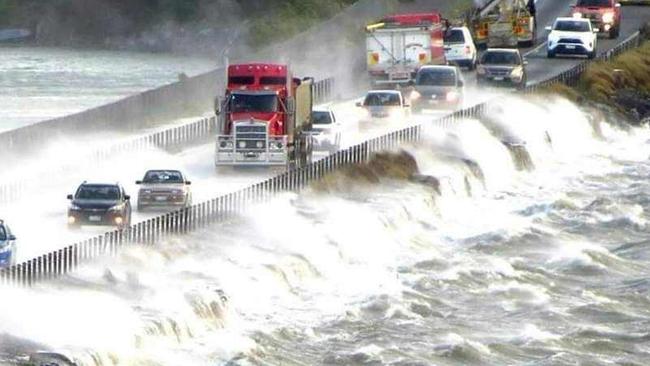
Motorists had to battle harsh conditions travelling to Hobart this morning, including surging swell smashing the causeway at Midway Point.
More information is expected later this morning on conditions SES services faced overnight.

Melbourne man a no-show at Hobart court over drug trafficking charges
A Melbourne man accused of major trafficking of methylamphetamine and cocaine has failed to show for his Wednesday court date. What happened in court.

EYE IN THE SKY: Police tap into Hobart surveillance network
Ever get the feeling you’re being watched? If you’re in the view of one of 300+ cameras across Hobart’s CBD, you very well might be. Here’s how the CCTV network is helping police fight crime.