
Tasmania predicted to dodge ‘Antarctic blast’ — mostly
A strong wind warning has been issued with rain and storms also the cards for much of the state over the next couple of days. FULL FORECAST: What to expect in your area >>

Tasmania
Don't miss out on the headlines from Tasmania. Followed categories will be added to My News.
- New rare apple grown in southern Tassie set to hit shelves
- Tassie golf club cans planned cull of wildlife
TASMANIA will dodge the worst of an “Antarctic blast” expected to hit the mainland states over the early part of the coming week, but we’ll still get rain, thunderstorms and damaging winds.
Areas of the nation’s East Coast are set to receive a significant dump of snow just as the ski season begins in the alpine regions.
A strong cold front is expected to start making its way across South Australia on Monday afternoon before hitting the southeast and the East Coast on Tuesday and Wednesday.
Tasmania’s central and southern regions are expected to receive snowfalls down to 900m.
Anna Forrest from the Bureau of Meteorology said the eastern states could expect some “pretty ordinary weather”, but Tasmania would largely be spared.
“The coldest air bypasses us and goes over Victoria and New South Wales, even into southern Queensland but we miss it entirely,” she said.
Locally, the forecast was highly variable across the state, with starkly different outlooks in different regions, she said.
“The worst of the weather is in the North and West Sunday, Monday and into the first part of Tuesday,” Ms Forrest said.

Hobart’s lowest temperatures in the early part of the coming week will be 7C on Wednesday and its highest will be 17C on Monday.
But the capital can expect up to 10mm of rain on Tuesday and 15mm on Wednesday.
Melbourne is expecting a top temperature of 13C on Tuesday and Wednesday, while Canberra will top out at 10C on Wednesday and Thursday.
Sky News Weather meteorologist Rob Sharpe said the snow forecast was looking “quite significant” for the mainland ski fields with falls down to about 1000m for parts of Victoria, NSW and southern Queensland.
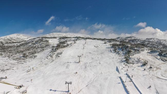
Mr Sharpe said the lower and mid-slopes of the alpine regions would be likely to receive 40cm to 50cm of snow, but up to one metre could fall on the upper slopes as “it might just stay cold enough for long enough”.
He said there was a chance of light snow in Queensland’s Darling Downs on Wednesday night or early Thursday morning.
A colder than average May prompted Perisher ski resort in NSW to open a week earlier than usual on Friday, while other holiday destinations are set to kick off the skiing season next weekend.
“This cool change will impact almost all of Australia, with the only exception being the Western Australia Kimberley,” Mr Sharpe said.
Hobart
Monday: Partly cloudy. Slight (30%) chance of a shower this evening. Winds north to north-westerly 15 to 25 km/h becoming northerly 25 to 35 km/h in the early afternoon.
Tuesday: Cloudy. Very high (90%) chance of showers. Winds north to north-westerly 15 to 25 km/h becoming light in the middle of the day.
Launceston
Monday: Cloudy. Very high (95%) chance of showers. Winds north-westerly 25 to 40 km/h turning northerly 35 to 45 km/h in the middle of the day then decreasing to 30 to 35 km/h in the late afternoon. 5—10mm of rain.
Tuesday: Cloudy. Very high (95%) chance of showers, most likely in the morning and afternoon. Winds northerly 25 to 35 km/h decreasing to 20 to 30 km/h in the morning then becoming light in the late afternoon. 15—20mm of rain.
Burnie
Monday: Partly cloudy. Very high (95%) chance of showers, most likely late this afternoon and evening. The chance of a thunderstorm this evening. Winds north to north-westerly 45 to 60 km/h becoming north-westerly 40 to 50 km/h in the late evening.
Tuesday: Cloudy. Very high (95%) chance of showers, most likely in the morning and afternoon. The chance of a thunderstorm in the late morning and afternoon. Winds north to north-westerly 35 to 45 km/h decreasing to 20 to 25 km/h in the morning then shifting south-westerly 15 to 20 km/h in the evening.
Strahan
Monday: Cloudy. Very high (near 100%) chance of showers. The chance of a thunderstorm late this afternoon and evening. Winds northerly 30 to 40 km/h turning north-westerly 20 to 25 km/h in the late evening.
Tuesday: Cloudy. Very high (95%) chance of showers. Winds north to north-westerly 20 to 30 km/h decreasing to 15 to 20 km/h early in the morning then shifting southerly 15 to 25 km/h in the late afternoon. 20—30mm of rain.
East Coast
Monday: Partly cloudy. Medium (50%) chance of showers about higher ground, slight (30%) chance elsewhere. Winds north to north-westerly 30 to 45 km/h.
Tuesday: Partly cloudy. High (80%) chance of showers. Winds north to north-westerly 25 to 35 km/h tending west to north-westerly and becoming light in the late morning and afternoon. Overnight temperatures falling to between 5 and 10 with daytime temperatures reaching between 10 and 15.

Titmus’ heartwarming moment meeting young fans in Launnie
Ariarne Titmus broke down in tears, overcome with emotion after meeting one young fan in Launceston. Here’s why.

Tassie DJ vying for world title after national championship win
After defending his national title, Tassie DJ Max Best will again battle it out at the world championships – and he believes this time he can go all the way.