
Snow, wind and flood watches issued for Tassie
Landslides and snow have closed several roads across Tasmania, as warnings for further ice, snow and rain are issued. LATEST FORECAST + ROAD CLOSURES LIST >>
Wintry weather is hanging around this week despite now reaching 20 days into spring.
Western Tasmanians, Central Highlanders, and even Hobartians, woke to low snow this morning as Tasmania Police issued road closures soon after.
Highland Lakes Rd from Poatina to Miena and Marlborough Rd was closed due to snow while motorist were urged to take caution on others.
Lake Dobson is open to 4WD with chains and emergency services urged drivers on Lyell Highway, between Bronte and Derwent Bridge, to drive with caution.
Today will remain wet and cold across much of the state with the state’s west expected to share in the majority of today’s rainfall.
Falls are expected to increase again on Thursday and Friday with 10mm expected in Hobart and larger falls forecast further west.

The Bureau of Meteorology cancelled a Severe Weather Warning yesterday but numerous warnings are now current with a sheep graziers warning for the South East forecast district and flood watch warning current for Northern Tasmanian catchments
Snow below 500 metres is also forecast through the week on the West Coast, Central Highlands, and in the South East.
An initial minor flood watch warning has also been issued for the North Esk River In particular.
CURRENT TASSIE ROAD CONDITIONS - UPDATES 1.10PM
- Cradle Valley – Belvoir Road – Leary’s corner to lookout slush on road
- Cradle Mountain Road – Lake Dove Road – Caution while driving in park
- Lyell Highway – light snow at Arrowsmith
- Due to snow, Pinnacle Road is closed at the Springs.
Tropical summer on the way for Tassie | September 19
A TASTE of the tropics is coming to Tasmania, with wet, warm weather over summer and a prediction for more thunderstorms.
Hobart is headed for its 20th year of above average temperatures for the seven-month period between next month and April.
Sky News chief meteorologist Tom Saunders said as well as being wet and humid, there was also the chance of increased flooding in Tasmania.
“I would say the key message is a warm and humid summer with thunderstorms being above average across the state,” Mr Saunders said.
“The risk of flooding, for example, in eastern NSW, is exceptionally high over the next seven months, but there is also an above-average risk of flooding across Tasmania.”
The predictions are contained in Sky News weather’s 11th annual long-range severe weather outlook compiled by Mr Saunders.
He said the next seven months would be wetter than average across most of Australia and temperatures would remain warmer in most regions.
“The major influence behind the forecast for warmer weather is the continued and increasing influence of global warming, which ensures most years are now hotter than historical averages,” Mr Saunders said.
“Every Australian capital, apart from Melbourne, has recorded at least nine consecutive years with above average maximum temperatures during the severe weather season (SWS).
“Sydney has now recorded 21 consecutive warm SWS years with temperatures above average.
“Hobart has recorded 19 consecutive years and Perth 15 consecutive years.”

For October to April, Mr Saunders expects the maximum temperatures in Hobart to be warmer than average, like last year.
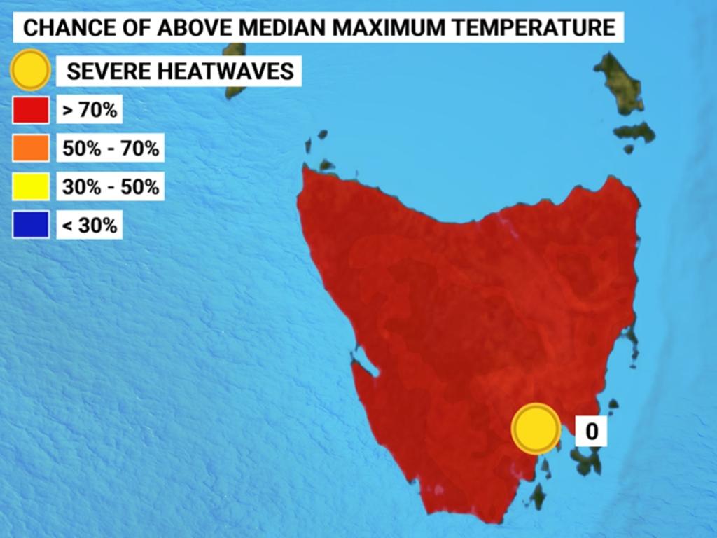
The prediction is for an 80-90 per cent chance of above median maximums – the highest percentage chance of any capital city.
The long-term average temperature for Hobart from October to April is 19.6C and the average maximum for 2021-22 is expected to be 20.5C.
There are no severe heatwaves predicted for Hobart.

Heatwaves are rare along Australia’s East Coast with Hobart, Brisbane and Sydney averaging fewer than one every 10 years.
Rainfall in Hobart is expected to be higher than last year and above average. Total rainfall for 2020-21 was 370.6mm compared with the long-term average of 352.4mm.
Mr Saunders predicts between three and seven days of severe thunderstorms in Hobart.
This is above the long-term average of four thunderstorms.
Severe thunderstorms can bring hail exceeding the size of a $2 coin, wind gusts exceeding 90km/h and flash flooding.
“We can’t pinpoint individual days and weeks. However, considering you were expecting humidity to be higher than normal. [So] the right ingredients will be in place for thunderstorms,” Mr Saunders said.
Wet and wild weekend: Snow, hail and thunderstorms
A series of cold fronts will cross Tasmania this weekend, bringing wet, windy and cold conditions to the state.
Meteorologist Debbie Tabor said Tasmanians should prepare now for a wild few days which will also see low-level snowfall.
“After a stable week of weather under the influence of a high pressure system, we’ve now seen it move over the Tasman Sea and we’re getting a freshening north to north easterly flow,” Ms Tabor said.
“Ahead is cold fronts and westerly winds so a cold front across Saturday morning, another one on Sunday afternoon and a cold front early on Monday.
“This will bring rain statewide for those days but particularly in the west on Saturday with the highest falls of 15 to 25mm.
Windy across #Tasmania in the coming days, especially during Sun. Wet across the state as well, particularly about the W and the NE with smaller totals about the E coast and parts of the SE. Snow to ~700m Sat and Sun, lowering to near 500m on Mon. Stay safe! pic.twitter.com/kelA73aQKN
— Bureau of Meteorology, Tasmania (@BOM_Tas) September 17, 2021
Ms Tabor said there would be some possible thunderstorms on Saturday as well, with strong and gusty north westerly winds on Sunday as another cold front crosses in the afternoon.
The strong and gusty north-westerly wind will shift westerly, with showers and rain in the morning and snow lowering to 800 metres.
“The winds will be very strong on Sunday; we are expecting some wind gusts to be up to 100km/h in parts,” Ms Tabor said.
“Particularly about the west and southwest early on Sunday extending to the southeast and the north in the morning and then the east and the northeast in the afternoon before easing.
“So it is highly likely we’ll have a severe weather warning for damaging winds getting up to around 100km/h in those parts for Sunday.”
Ms Tabor said another cold front would cross early on Monday, with showers across the state — more frequent in the west.

“(It will be) a very cold day with snow lowering to around 500 metres,” she said.
“There will be possible thunderstorms about and hail and another day of very strong westerly winds which will shift south-westerly in the afternoon.
“20—30mm of rainfall is expected to be the highest falls in the west … with snow to around 400 metres early on on Tuesday.
“So it’s quite typical of a spring pattern transitioning from winter with a westerly stream dominating and some snow to lower levels.”
The Bureau warned four-day rainfall totals to Monday evening would likely be 40-80mm in the west (with falls greater than 100mm possible about higher ground), 20-40mm in the
north and 2-8mm in the east and southeast.
Rivers may respond to rainfall and if required a Flood Watch will be issued.
A road weather alert, sheep graziers warning and bushwalkers weather alert
may be issued for Monday.
Join the conversation

Jury asked to consider intent behind “loaded gun” pointed at head
Read more

Planning chief: Stadium’s economic case has worsened
Read more