
WEATHER WARNING: Low snowfall prompts ‘hazardous’ alert
Rug up, Tassie! Snow is likely to fall as low as 700m, with warnings issued for those venturing outdoors. SEE THE LATEST FORECAST >>
- Man flown from Flinders to Hobart in serious condition after crash
- Ex-girlfriend of murder accused recounts night alleged killing
UPDATE
Sunday May 16
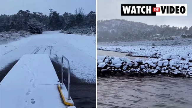
Bushwalkers have been warned of cold, snowy and “hazardous” weather coming to Tassie.
The Bureau of Meteorology issued the warning that snow as low as 700m tonight and in the early hours tomorrow morning could be dangerous for those brave enough to venture outside.
“These hazardous conditions are expected to occur in parts of the Western and Central Plateau forecast districts,” a BOM alert read.
Tasmania Police reminded locals to check the police community alerts page before they headed out for the latest road closures.
“This includes carrying chains for your vehicle if you’re intending on getting in on some snow action,” a Tasmania Police Facebook post read.
“Slow down, pop your headlights on and drive to the slippery conditions.
“Bushwalkers – if you’re intending on heading into the wilderness – be aware of the hazardous conditions, be prepared, pack plenty of warm clothing, food, water and a personal locator beacon.”
The rest of today will see showers across Tasmania, possible hail in the southwest and south, and fresh, gusty westerly winds tending west to south-westerly along with snowfall to 700m.
The cold front will continue on Monday, as showers plague the west and far south and snowfalls continue to reach 700m in the early morning.
Liawenee will drop to -2C on Monday and reach a high of just 5C, while Ben Lomond will fall to -5C and climb to 1C.

Kunanyi/Mt Wellington’s temperatures will sit between -2C and 2C for Monday.
Morning frost and westerly winds and gusts will impact the state on Monday and Tuesday.
A strong wind warning for the rest of Sunday is in place at Storm Bay, Far North West Coast, Central North Coast, Banks Strait and Franklin Sound, East of Flinders Island, Upper East Coast, Lower East Coast, South East Coast, South West Coast and Central West Coast.
For Monday, the warning will remain in place at Far North West Coast, Central North Coast, East of Flinders Island, Upper East Coast, Lower East Coast, South East Coast and South West Coast, but will ease elsewhere.
EARLIER:
THOSE enjoying the snow this weekend will be glad to know more is on the way, with another cold front expected to cross the state on Sunday night.
Hobartians woke to a light dusting of snow on Mt Wellington on Saturday, with many families getting in early to make the most of the icy fun.
Hobart dropped to 2.7C overnight, while Bushy Park (-1.4C), Campania (-0.9C), Grove (-0.4C) and Mt Wellington (-3.5C) all dropped below zero.
The Bureau of Meteorology’s Luke Johnson said showers were expected to continue on Sunday in the West, with snowfall to around 1100m.
Snowfall to 700m will be likely again overnight as another burst of cold air crosses the state, extending showers statewide in the evening.

“A series of cold fronts in recent days has brought consistently colder air over Tasmania, with one more cold front expected to cross the state Sunday night,” Mr Johnston said.
“More settled conditions will follow into next week high a ridge of high pressure becomes dominant over Tasmania for a few days. However, cold mornings and frosts remain likely, particularly about the East and northeast of the state.”

Sisters Isabella and Aurora Braham, of South Hobart, wasted no time getting among the snow action on Saturday morning.
Mum Giavana Vicola said the family had moved to Tasmania in January from Brazil.
“We kept coming back every year or so and we just love the lifestyle and the access to the snow and so we chose to live somewhere close to the mountain for that reason,” she said.

Pinnacle Road on kunanyi/Mt Wellington was open to the summit for a only few hours on Saturday with a pre-emptive closure at The Springs at 4pm due to the forecast snow.

Lake Dobson Road at popular snow spot Mt Field National Park was open for four-wheel drive and all-wheel-drive vehicles as well as two-wheel drive vehicles with chains fitted.
Hobart forecast:
Sunday: 7-14 showers increasing
Monday: 6-13 cloudy
Tuesday: 8-17 partly cloudy
Wednesday: 10-18 partly cloudy
Thursday: 10-15 shower or two
Friday: 6-16 partly cloudy
White-out on the way as cold front slams Tassie
The cold snap has hit and it is set to get even colder across Tasmania.
The Bureau of Meteorology’s Luke Johnston said snow has fallen to around 800 metres overnight and forecast to fall to around 500 metres this evening and into tomorrow morning.
“Most of the snow we’ve seen falling and will see fall today will occur about the west, the south and the Central Plateau, with the north east highlands being mostly shelter,” Mr Johnston said.

According to the BOM, an easing in winds during the overnight period brought frosty conditions and temperatures below 1C overnight in the north east of the state, with subzero
temperatures at elevated areas.

Temperatures are expected to fall to -2°C in the north and north east overnight tonight, with near zero temperatures expected inland in the south east.
“Colder temperatures tomorrow will be well below the May average by a few degrees, more likely in line of what we see for a June or winter’s day in Tasmania,” Mr Johnston said.
Authorities are urging people to prepare for the conditions and for motorists to take care on the roads with cold weather bringing icy conditions.

“There’ll be a little bit of reprieve from fresh snow during Saturday afternoon and Sunday morning, with fresh snow returning to around 700 metres on Sunday evening,” Mr Johnston said.
The BOM has issued a road weather alert for snow on elevated roads through tonight and tomorrow morning, as well as a bushwalkers weather alert for the Central Plateau and western forecast districts.

Police have issued the following warnings for road conditions:
- Highland Lakes Road – Snow from Steppes to Miena / Miena to Liffey Falls turn-off – Extreme Caution
- Lyell Highway – Patchy, light snow Bradys Lake to Derwent Bridge – Extreme Caution
- Lake Dobson Road – 100mm snow at Snow Tops section – Wombat Moor – Extreme Caution – 4X4 equipped with chains only
- Malborough Road – Light snow Miena to McKenzie Tier (20mm) – Extreme Caution – 4X4 only
- Lake St Clair Road – Patchy, very light snow throughout – Extreme Caution
- Poatina Road – Snow from Highland Lakes Road to Poatina Village – Extreme Caution
- Blessington Road / St Leonard Road – Corra Lynn Bridge iced over, remainder clear – Extreme Caution
- Zeehan Highway, Queenstown to Zeehan affected with ice and sleet on road – Extreme Caution
Snow, showers, hail and frost to round off a bitter Tassie week – Thursday, May 11
Snowy and frosty mornings with a spot of showers and hail will finish off an already chilly week according to the latest weather outlook as authorities issue numerous warnings.
The Bureau of Meteorology expects snowfalls to around 800 metres likely about western, southern and central Tasmania this evening, lowering to around 500 metres Friday evening into Saturday morning.
Snow is still expected to fall about the northeast highlands, but a smaller depth and
to a slightly higher elevation.
“An easing in winds during the overnight periods will bring widespread frost to
inland parts of the state, particularly in the north for the coming days,” Meteorologist Luke Johnston said.
Cold Front today, with cold speckled cloud behind it bringing snow to around 800m tonight. A Colder Front tomorrow, bringing colder thicker speckled cloud and snow to around 500m Friday night! #brr
— Bureau of Meteorology, Tasmania (@BOM_Tas) May 13, 2021
Road Weather Alert, Frost Warning, Bushwalkers Alert: https://t.co/llHJKKNSjlpic.twitter.com/h4VtteZARV
“A frost warning is current for Friday, with further warnings for frost expected for the
weekend.
“A Road Weather Alert is current for snow on elevated roads for the coming days, and a Bushwalkers Weather Alert is current for the Central Plateau and Western forecast districts.
“A cold front this afternoon, followed by a second and colder front on Friday will
bring these brisk conditions over Tasmania.”
Mr Johnston said the cold fronts mark a change from the milder weather experienced in recent days, and temperatures over the weekend will be below average by several degrees.
Authorities are urging people travelling across the state, vulnerable people or those planning on going bushwalking to prepare for these conditions and stay up to date with the
latest forecasts and warnings on the BOM website.
Severe frost warning issued as temps plummet to -4C | Tuesday, May 11
Severe frosts with temperatures as low as -4C will hit the south of the state tomorrow morning as authorities issue warnings for crop damage.
According to the Bureau of Meteorology, the low temps may cause significant crop damage on Wednesday morning in parts of the Upper Derwent Valley.
Frosts and temperatures down to -2C are also expected for parts of the Central North, Midlands and South East forecast districts.
â„ï¸ It's going to be a cold start for #Tasmania tomorrow!
— Bureau of Meteorology, Tasmania (@BOM_Tas) May 11, 2021
âš ï¸ A Severe Frost Warning has been issued for the Upper Derwent Valley, and a Frost Warning for the Central North, Midlands and South East.
💻 Check your forecast at https://t.co/89tUjpsH2xpic.twitter.com/VLQcFwh1vl
“Temperatures at ground level can be many degrees lower than those recorded by standard weather stations, especially in calm conditions with clear skies,” the BOM warns.
In the major centres, Hobart will hit a max of 16C after a low of 6C, Launceston will hit 16C after a low of 1C, and Burnie will reach 16C after a low of 3C.

‘Game changer’: New free health clinic opens in Sorell
