
Hobart suburbanites urged to prepare for a ‘worst case’ bushfire scenario this summer
Research into the giant thundercloud that formed over Dunalley during the 2013 bushfires has found that Hobart is particularly vulnerable to such catastrophic firestorms.
Tasmania
Don't miss out on the headlines from Tasmania. Followed categories will be added to My News.
- New report reveals the five Tasmanian municipalities most at risk of bushfire
- Major upgrade to emergency services radio network announced
HOBART’S bushfire risk has been likened to “living on the edge of a volcano” and suburbanites are being urged to prepare for a “worst case scenario” this summer.
Research into the giant thundercloud, known as a pyrocumulonimbus (pyroCb), that formed over Dunalley during the 2013 bushfires has found that Hobart is particularly vulnerable to such catastrophic firestorms.
“We always knew that it was dangerous because of 1967, but the risk of pyroCbs from the analysis has increased that,” said head of fire research at the University of Tasmania David Bowman, who described the findings as “disturbing”.
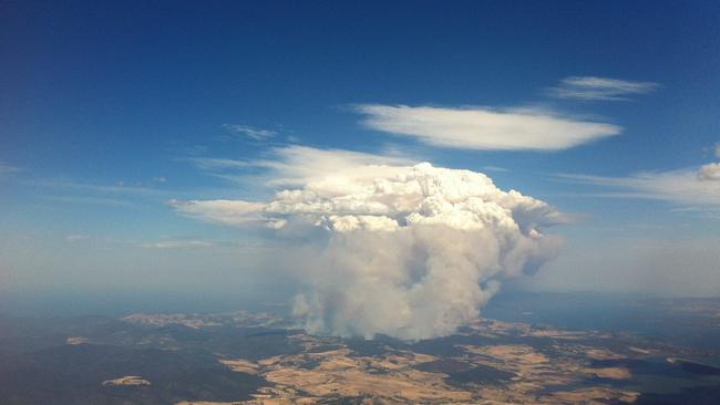
PyroCbs develop rapidly to create their own nightmare weather, including strong winds, cloud-to-ground lightning strikes and even possible tornadoes.
“Hobart is smack bang in the middle of the Derwent Valley, which is basically a flume designed to generate pyroCbs. It just ticks all of the boxes,” Professor Bowman said.
“You could call the Derwent Valley or this corner of the state ‘Fire Thunderstorm Alley’. This is a dangerous part of the world. It’s like living on the edge of a volcano.”
Tasmania Fire Service’s bushfire risk mitigation manager Chris Collins said there was a theory that the occurrence of pyroCb events during bushfires was increasing globally.
“This theory would stand to reason, as the intensity of bushfires is observed to increase,” Mr Collins said.
He said risk modelling showed Hobart, as well as many other Tasmanian communities, were at risk of bushfire — a risk that will increase when lush growth dries off in the new year.
“However, the risk from bushfire can be reduced, and has been reduced in the Greater Hobart area via fuel management, emergency planning, and increased response capability,” Mr Collins said.
“It is vitally important that Tasmanians prepare themselves and their property for bushfire. The mitigation of bushfire risk is truly a collective responsibility.”
Prof Bowman said the study, co-authored by the University of New South Wales and Bureau of Meteorology, should be a wake up call to Tasmanians, including those in suburban Hobart.
“Under catastrophic conditions there are many suburbs in Hobart that are very dangerous and the most prudent thing is to leave well early. The suburbs on the slopes of the mountain are obvious examples, but the bush is close to nearly all suburbs,” he said.
“There needs to be, in my opinion, much better assessment of individual home risk to help the community understand the risks inherent in living in a city surround by bushland. It is clear to me most folk are unaware of the inherent risks of bushfires in Hobart.”
The study team used six-minute scans from the Mt Koonya weather radar station to track the fire cloud’s incredible speed — reaching 15km high in 24 minutes.
“(The) fire was generating so much heat and smoke and water vapour … that it developed its own thunderhead,” Prof Bowman.
“The reason that we worry about these fire storms is that there is no technology that can deal with them. Basically, you’re down to your prep. If your house is not really equipped to deal with one of these fire storms, then you’ve got to be not in your house. You need to evacuate in the face of dangerous fire weather.”
It is the only confirmed pyroCb recorded in Tasmania, but at least 30 formed across Australia during the last fire season alone.

Lucky Tasmanian quickly retires after $900k lottery windfall
After learning they had won more than $900,000 on a winning TattsLotto entry over the weekend, a Tasmanian resident has quit their job and is now busily considering new life opportunities.

‘Will get worse’: Economist’s post-election warning
Saul Eslake has warned for years about the “dire” state of Tasmania’s finances. Read his sobering thoughts on the state election results.