
Flash flood warnings for Tassie with wet and windy weekend ahead
It’s looking to be a wet and windy weekend across the state, with the weather bureau warning rainfall may lead to flash flooding. LATEST FORECAST >>
Tasmania
Don't miss out on the headlines from Tasmania. Followed categories will be added to My News.
- Aussie legend: Ariarne’s tears after historic win
- Housing market’s ‘insurmountable pressure’ pushes values higher
It’s looking to be a wet and windy weekend across the state, with authorities warning rainfall may lead to flash flooding.
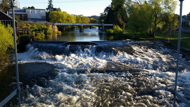
The Bureau of Meteorology on Friday said catchments across Tasmania were wet and rivers would be highly responsive to additional rainfall.
“Continuing rain into the north and west means that minor to moderate flooding will continue in many catchments over the weekend and into next week,” the bureau said.
Continuing rain, esp. in the north & west, means minor to moderate flooding will continue in many catchments over the weekend & into next week. Catchments are wet & rivers highly responsive to rain. Stay up to date with warnings, take care near waterways. https://t.co/Ksim5AQG6Tpic.twitter.com/m2tVHP1StM
— Bureau of Meteorology, Tasmania (@BOM_Tas) July 30, 2021
Widespread rainfall totals of 15-30mm are forecast about the north and west for Saturday, with 45-60mm on the western tiers and 10-20mm in the centre and far south.
Minor flood warnings are current for the Macquarie, Meander, North Esk, South Esk, Mersey, Forth rivers, and the River Derwent.
“Winds will become strong and gusty overnight on Friday and during Saturday due to an approaching cold front,” the bureau said.
“Cold and blustery conditions are expected on Sunday in the wake of the front, with
the snow line lowering to around 700 metres.
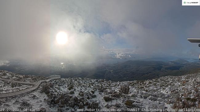
Snow dump closes Tassie roads, flood and wind warnings remain
HEAVY snow has closed a number of roads around the state, authorities have confirmed.
The City of Hobart has closed Pinnacle Rd at the springs while Police have closed two roads in the Highlands.
Tasmania Police have closed Highland Lakes Road between Hunterston and Marlborough Junction.
Lake Dobson Road in Mount Field is also closed.
Wind and flood warning also remain in place for parts of the state.
Strong Wind Warning is current for Central Plateau Lakes, Central North Coast, Banks Strait and Franklin Sound, East of Flinders Island, Lower East Coast, South East Coast, South West Coast and Central West Coast.
âš ï¸MINOR #Flood Warning issued for #RiverDerwent Below Meadowbank Dam from Thursday morning. Strong river rises occurring upper Derwent, Nive, Florentine, Tyenna, Styx and Plenty. See https://t.co/V9LYfDAYDq for details and updates; follow advice from @SESTasmania. #TasFloodspic.twitter.com/ElInuwVfvp
— Bureau of Meteorology, Tasmania (@BOM_Tas) July 28, 2021
The following flood Watches/Warnings are current:
- Moderate Flood Warning for the North Esk River
- Moderate Flood Warning for the South Esk River
- Minor Flood Warning for the Macquarie River
- Minor Flood Warning for the Meander River
- Initial Minor Flood Warning for the River Derwent
- Flood Watch for Derwent, North West, North and North East catchments
âš ï¸MINOR #Flood Warning issued for #RiverDerwent Below Meadowbank Dam from Thursday morning. Strong river rises occurring upper Derwent, Nive, Florentine, Tyenna, Styx and Plenty. See https://t.co/V9LYfDAYDq for details and updates; follow advice from @SESTasmania. #TasFloodspic.twitter.com/ElInuwVfvp
— Bureau of Meteorology, Tasmania (@BOM_Tas) July 28, 2021
Flooding, strong wind warnings as cold blast hits Tassie – Wednesday, July 29
Weather experts are keeping their eyes “fixed pretty firmly” on a number of rivers across Tasmania, with rainfall leading to flooding over the coming days.
BOM hydrologist Ashley Greenwood said there was a moderate flood warning for the North Esk River and minor flood warnings for the Meander and South Esk Rivers.
“We also have a flood watch current for the Macquarie River, Ringarooma River, North Coastal Rivers, Mersey River, Forth River, Northwest and Central Coastal Rivers, the Arthur River and the Derwent River,” Mr Greenwood said.
“We’ve had a bit of rain recently, culminating in 40-60mm to 9am Wednesday. The catchments are very wet and we have a further 20-40mm forecast about the north, predominantly for Friday and into Saturday with falls of 60-90mm possible in elevated areas.”
Mr Greenwood said some rivers may actually increase the flood level to moderate level.
“At the moment we’re keeping our eyes fixed pretty firmly on the Meander River, which might exceed moderate flood levels later in the weekend after the weekend’s rain,” he said.
Mr Greenwood gave some advice to residents who live near the flood watch catchments.
“Stay away from any water you see on the road and keep across all the flood warnings on the Bureau website and Twitter and keep track of the messages you’re likely to see from the State Emergency Services,” he said.
BOM meteorologist Luke Johnstone said it would likely be a windy week as well, with a gale warning for many areas across Tassie and a strong wind warning for Frederick Henry Bay and Norfolk Bay, Storm Bay, Channel and South West Lakes.
“Strong and gusty north westerly winds are expected in Tasmania overnight into Wednesday, with wind gusts of 80 to 90 km/h likely about much of the west and north of the state,” he said.
“Wind gusts at elevated areas and over King Island will likely receive gusts nearing 100 km/h.”
“The strongest winds are expected to arrive in the northwest late Tuesday night, and extend over the state during the early hours of Wednesday, before gradually moderating during Wednesday afternoon.”
The harsh weather comes as a series of cold fronts crossing Tasmania in the coming days.
“The most significant ones are expected to be Wednesday afternoon and Saturday night, bringing snowfalls to around 700 metres on Wednesday night and Sunday,” Mr Johnstone said.
A Sheep Graziers warning is current for the King Island, Furneaux Islands, North West Coast, Central North, North East, Midlands, East Coast and Upper Derwent Valley forecast districts.
Hobart City Council advised that a pre-emptive closure of Pinnacle Road at The Springs will happen at 6pm Wednesday due to forecast snow.

Family of six trapped by snow overnight rescued
A family of six, including three children, have had a cold and anxious overnight wait on Mt Field, after heavy snowfall left them stranded in a hut. The latest.

‘Quickly became dangerous’: Family choppered off mountain
A family of six, including three children, has been rescued from Tasmania’s Mount Field National Park after being stranded by heavy snow overnight.