Tasmania weather forecast: Calm weather disrupted by two high pressure systems
Tasmania’s serene weather which has dominated April is about to shift. Here’s what we can expect for the final week of school holidays >>

News
Don't miss out on the headlines from News. Followed categories will be added to My News.
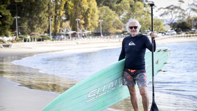
Steven Last felt like he was dancing on water after paddle boarding in the glassy waters of Long Beach on Sunday morning.
It was perfect weather conditions for the 60-year-old to exercise while marvelling in nature.
“If you’re there at 6.30 in the morning, you’ve actually in all these wonderful conditions, so you see marine life and it’s like dancing on water,” he said.
“I saw stingrays, I didn’t see many school fish but on a good day you can paddle from here to Taroona High School.”
The architect, who has been surfing since he was 15 years old, said the surfing conditions have been average this year.

“It’s been a very spontaneous, adrenaline search for that raw aquatic energy,” he said.
“But stand up paddle boarding gives you a wonderful grounding and nurturing to nature. It also provides a floating platform to view the sensational coastal architecture and environments.”
The calm conditions have dominated April according to Bureau of Meteorology senior meteorologist Michael Conway.
But it will be disrupted as two high pressure systems move over the state in the coming week.
“One is moving to our north and that will move out to the North East on Monday,” he said.
“Then we’ll see a trough or a weak front build over The Bight on late Monday into Tuesday and then we will get that system cross Tasmania from late Tuesday night through Wednesday morning, so we will get a little bit of rainfall out of that.
“We’ll get another high beginning to build south of Western Australia, which will come to dominate our weather through Thursday, Friday, Saturday and Sunday.”
Mr Conway said the winds will pick up as the system is crossing.
“On land, we’re going to see some gusty conditions begin to develop on Tuesday ahead of this approaching front,” he said.
“Probably in the order of, 40 to 60km/h but maybe getting up to 70 to 90km/h about elevated peaks like Mt Wellington/kunanyi.”
Mr Conway said Anzac Day will be chillier because of a south-westerly stream.
“We will see those showers pushing certainly through Western Tasmania and probably through the far South. At the moment, it’s not looking like we will see the showers through Hobart,” he said.

Forecast
It will be partly cloudy and a top of 21C in Hobart on Monday and Tuesday, with a shower or two and maximum of 16C on Wednesday. Thursday will be cloudy and 14C before slightly warming up to 17C on Friday.
In the North, Launceston will be partly cloudy and 20C on Monday and Tuesday, with a shower or two and 17C on Wednesday. Thursday will be a cloudy 17C with Friday having a sunny 18C.
To the West, Strahan will be having a wet week, with a top of 17C on Monday and Tuesday. Showers will continue on Wednesday with a top of 15C, easing into Thursday with a maximum of 14C.
Across the East, Swansea will have sunny 21C Monday and a partly cloudy Tuesday. A shower or two will develop on Wednesday with a top of 17C, before clearing on Thursday with a cloudy 15C.


