
Antarctic blast to bring frosty starts for Queensland
Queenslanders have been left shivering on the first day of an expected week of chilly winter weather, as an Antarctic blast makes its presence felt in the southeast, sending temperatures plummeting.
Regional News
Don't miss out on the headlines from Regional News. Followed categories will be added to My News.
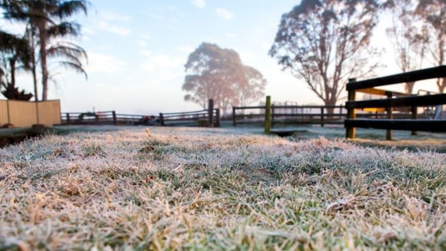
Queensland towns shivered before the sun rose, with freezing “feels like” temperatures as polar blasts from the Antarctic hit the Sunshine State.
A pair of cold fronts moved across the state over the weekend, with bitter winds and cold temperatures expected to be felt across the southeast this week.
Before sunrise on Monday, several towns in regional Queensland, primarily the Darling Downs and South Burnett, recorded apparent temperatures well below zero.
In the Darling Downs, Oakey was 1.9C with a “feels like” temperature of -2.4C at 4.30am, while nearby Wellcamp Airport at 5am was 0.5C, which felt like -2.3C.
In the South Burnett, Kingaroy recorded a minimum temperature of 0.3C with an apparent temperature of -1.5C at 6am.
Brisbane hit a cold point of 8.5C, with an apparent temperature of 7.7C at 3.30am, while on the Sunshine Coast it was 6.9C, despite it feeling like 3.5C at 5.30am.
It was slightly warmer further south on the Gold Coast, with a minimum temperature of 12.8C and apparent temperature of 9.2C recorded at 6am.
Bureau of Meteorology meteorologist Helen Reid said winter is starting to set in across Queensland.
“We have seen … quite a chilly start for a few places, particularly in the southern parts of Queensland,” she said.
“Kingaroy managed to at this stage dropped down to just above zero, while Oakey and Wellcamp Airport were also quite cold.”
In terms of the likelihood of snow in the southern parts of Queensland from Monday into Tuesday, Ms Reid said it would be a “very lucky” occurrence if it did eventuate.
“Unfortunately, the air doesn’t look to be bringing much in the way of rainfall through to the over the Queensland border,” she said.
“It would be a very lucky occurrence if we did see some snow on this occasion.”
Ms Reid added that Queensland residents should rug up, with more cold mornings on the way.
“There’s this cold air and even though it won’t bring snow, it will bring very cold mornings,” she said.
“We will be looking at frost spreading through quite not just southern Queensland, but also a little bit further north into probably the central, northern-central parts of Queensland.
“Later in the week, that cold air and those conditions might even drift that bit further north as well.”
Queenslanders have been warned to expect a proper week of winter, with the stubborn cold front to kick off properly on Tuesday.
Stanthorpe can expect to reach a low of 4C with a maximum of 11C, bringing frosts to the area, although the weather forecast is otherwise clear with a light westerly wind.
The conditions are expected to persist through Wednesday, with Thursday warming to a minimum of 3C and a maximum of 12C before the weekend with a maximum of 14C.
Bureau of Meteorology expert Harry Clark said it was rare for winds from Antarctica to stay cold long enough for snow to fall in Queensland, but it does occasionally happen.
“So, to get snow in Queensland, you’d need the air mass to be a bit colder than the one we’re expecting,” he said.
South East Queensland is also expected to feel the chill, with Brisbane dipping to 9C on Tuesday and maximum of 19C.
Maximums aren’t expected to move above 21 for the rest of the week, with clear skies and plenty of sunshine.
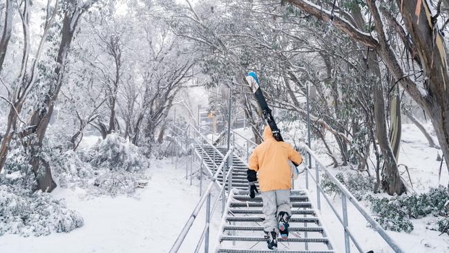
Elsewhere, the ski season has kicked off with a bang as the cold snap continues to blanket southeastern parts of the country, triggering heavy snowfall across the NSW and Victorian ski resorts.
Originally published as Antarctic blast to bring frosty starts for Queensland

‘We’re going to deliver’: Premier vows Olympic rowing will be held in Rocky
Premier David Crisafulli has vowed to keep his promise to host Olympic and Paralympic rowing in Rockhampton, despite the outcome of a global assessment on the Fitzroy River.

Baby hurt in fire extinguisher attack
A five-month-old baby was one of two injured when two people riding e-scooters pulled up alongside a car and discharged a fire extinguisher into it.