
Tropical low off Qld forms as Cyclone Alfred, could be category 3 within days
A low lingering off the coast of North Queensland has officially formed as Tropical Cyclone Alfred and could reach a category 3 before it heads toward the coast, the Bureau of Meteorology has warned.
QLD News
Don't miss out on the headlines from QLD News. Followed categories will be added to My News.
What was a low lingering off the coast of North Queensland has officially been named Tropical Cyclone Alfred and could reach a category 3 before it heads toward the coast, the Bureau of Meteorology has warned.
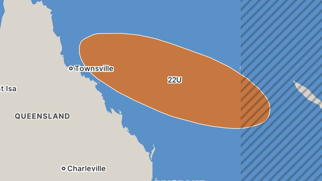
The category 1 cyclone was at 4pm Sunday about 400km east-northeast of Willis Island and 840km east of Cairns and heading east at a rate of 16kmh, strengthening as it moved.
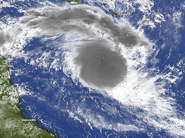
Winds near the centre of the cyclone were 75kmh, with gusts to 100kmh.
Although the low is expected to remain in the Coral Sea for now, there is a risk it would move closer to the Queensland coast later in the week as a category three cyclone.
“During the week Alfred is expected to turn southeast and then south while continuing to strengthen. Considerable uncertainty exists in the track the system will take beyond that, but there is a risk it will move closer to the central Queensland coast later in the week,” the BOM’s latest cyclone information bulletin said.
Senior meteorologist Angus Hines earlier said there was a real risk that the weather system could develop into a significant event for Queenslanders.
“It could reach category three by the end of this week as it continues to pick up strength and steam from the warm waters of the Coral Sea,” Mr Hines said.
“There is a risk it could bring pretty significant and severe weather over parts of Queensland next weekend.”
But for now, the risk to the community is minimal.
“It is going to stay at least 1000km away from the mainland coast of Australia for the majority of this week,” said Mr Hines.
“There are a variety of paths it could take, with only a couple making landfall, but there is a chance it could veer back towards the Australian coast.
“Even if it doesn’t make landfall it could bring some significant weather - my advice is for Queenslanders to keep an eye on it.”
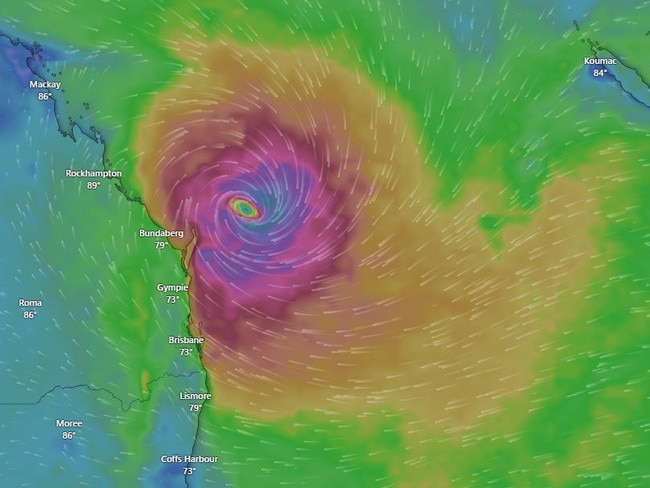
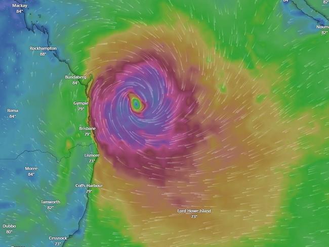
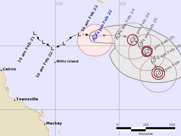
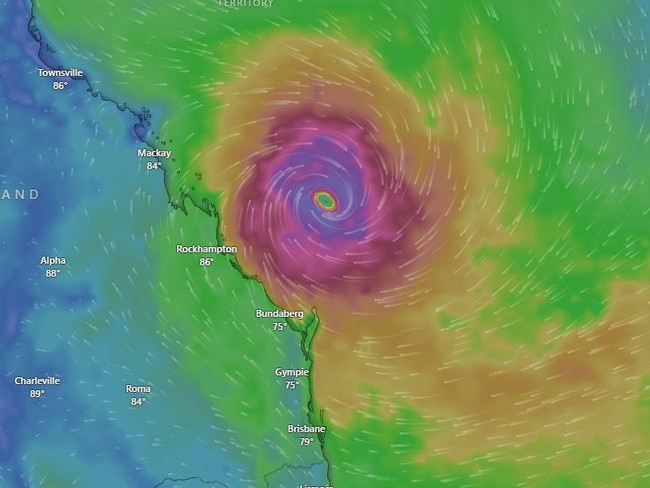
The BoM’s tracking map extends to Wednesday, predicting the system to move east until late Monday when it starts to veer southeast, becoming a category 3 by Tuesday and swinging further south by Wednesday.
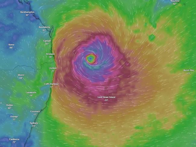
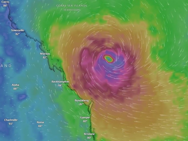
There is no indication given of the system’s strength from then but Windy.com tracking maps then show the system start to swing towards the Queensland coast before sitting off the coast next weekend between Rockhampton and Mackay and swinging southeast again, passing off the coast of Bundaberg next Monday March 3, Gympie the following day and off Brisbane March 4 to 5, and continuing southeast.
Originally published as Tropical low off Qld forms as Cyclone Alfred, could be category 3 within days

‘They are aching’: Leaders among hundreds at Brisbane rally
Hundreds of people, including several politicians, gathered in King George Square on Sunday for the Stand With Ukraine rally.

‘All actions considered’: Qld nurses could strike over pay offer
The state’s biggest union, covering nurses and midwives, has not ruled out taking strike action if the government refuses to budge on its latest pay offer. The Premier has now responded.