
Cyclone Alfred: SE Qld residents to brace for power outages, service shutdowns
The Prime Minister is on his way and tens of thousands are being warned to pack their bags in the hours after TC Alfred officially turned, headed for South East Queensland, bringing 400mm daily rain totals and 150km/h winds.
QLD News
Don't miss out on the headlines from QLD News. Followed categories will be added to My News.
Tropical Cyclone Alfred has turned and is on a collision course with South East Queensland.
Authorities confirmed just before 4pm on Tuesday afternoon that the system had turned and was now heading in a westerly direction, towards the Queensland coast.
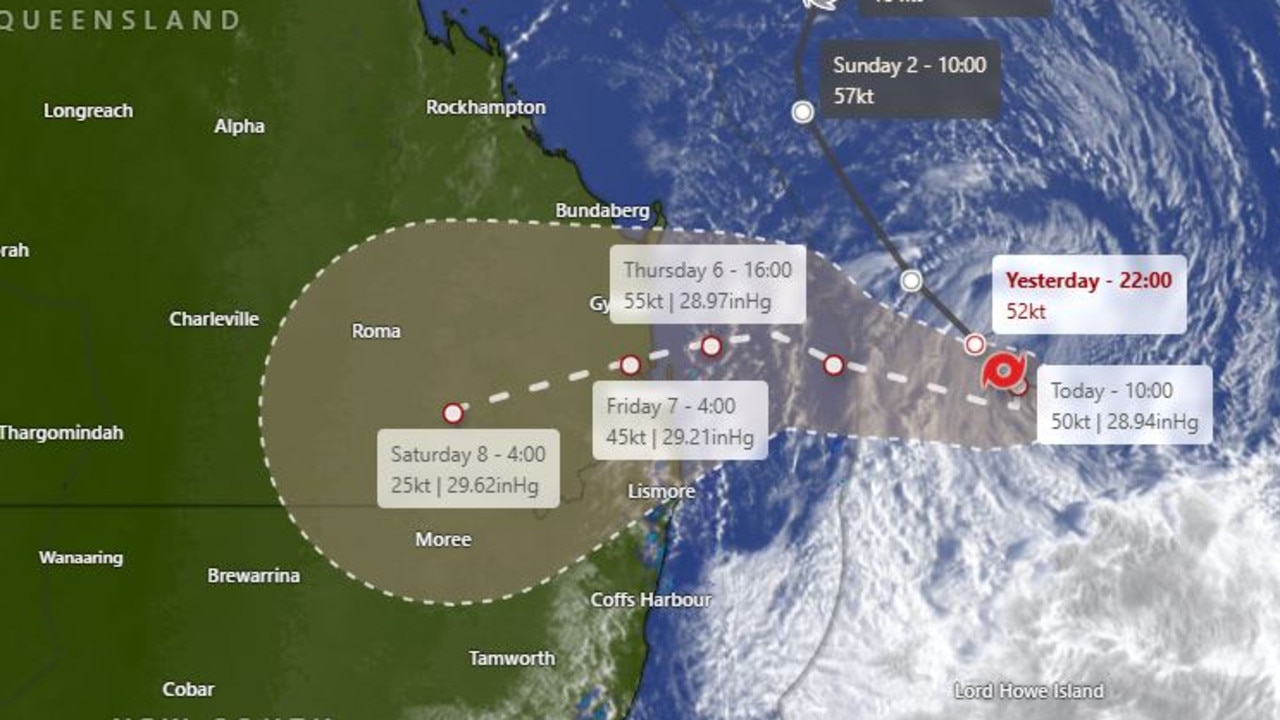
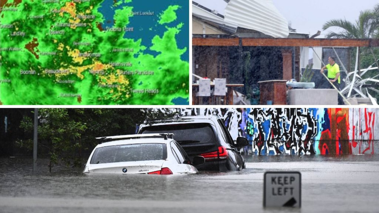
The system is forecast to intensify to a Category 2 before making landfall and will deliver damaging winds of up to 150km/h, up to 400mm of rain a day and waves as high as 10m.
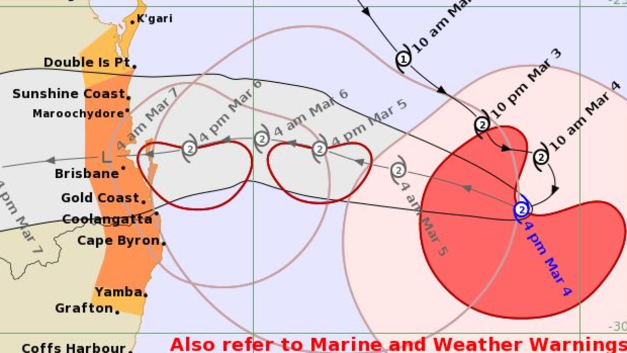
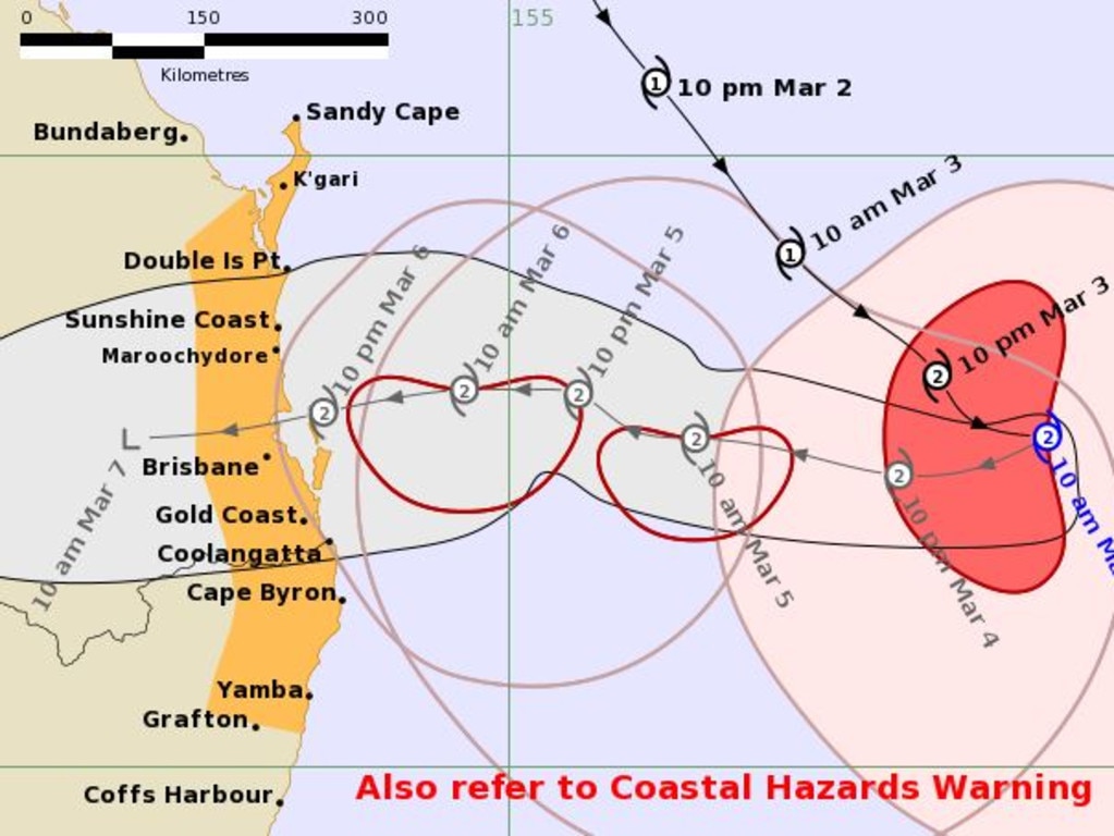
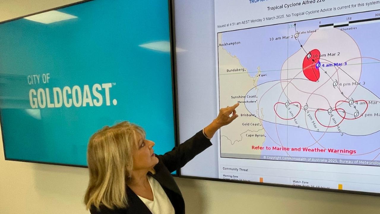
The latest tracking path from the Bureau of Meteorology shows the predicted path taking the centre of the Category 2 system over Brisbane’s northern suburbs, with the most intense rainfall expected to the south.
Prime Minister Anthony Albanese will arrive in Brisbane on Tuesday night, hours after Tropical Cyclone Alfred turned west toward Queensland.
He will receive regular briefings, with the federal government vowing to work closely with Queensland and New South Wales in preparation for the Category 2 system to cross the coast early on Friday morning.
Shock new flood modelling released today by Brisbane City Council shows 20,000 people in a dozen suburbs need to start packing their bags.
It comes as the City of Moreton Bay sent out a Watch and Act warning for Tropical Cyclone Alfred on Tuesday evening which called for people to take action now and Gold Coast City Council warn up to 6000 homes are at risk of inundation.
Lord Mayor Adrian Schrinner issued his own grim warning on Tuesday evening, based on new modelling undertaken by Council using the latest Bureau of Meteorology forecasts.
He said there could be impacts not recognised by the current Bureau of Meteorology forecast.
The modelling showed almost 20,000 properties in parts of 15 low-lying suburbs could be affected by storm surge or flooding.
According to the modelling, areas most at risk included Nudgee Beach, Brighton, Windsor, Ashgrove, Morningside and Rocklea.
The Bureau of Meteorology expected peak storm surges to occur from Thursday.
Several events have been cancelled or postponed, while several South East Queensland venues, attractions and restaurants have announced they will be closed for at least three days.
Schools are expected to remain open for at least Wednesday, but are expected to close from possibly Thursday.
The Bureau of Meteorology updated its cyclone tracking map and advice at 4.43pm Tuesday, to confirm TC Alfred was heading to the Queensland coast.
“Tropical Cyclone Alfred is moving towards the southeast Queensland coast.” the alert read.
“Gales with damaging wind gusts to 120km/h are expected to develop along the southeast Queensland and northeastern New South Wales coastal and island communities … Destructive wind gusts of up to 155km/h may develop about the exposed coastal and island locations near and to the south of the track as Alfred’s destructive core approaches and crosses the coast late Thursday or early Friday.
“Dangerous storm tide may occur along the coastal foreshore, particularly in areas near and south of the cyclone centre, if the time of coastal crossing coincides with the high tide during Thursday night or early Friday morning.
“Heavy rainfall is forecast for southeast Queensland and northeastern New South Wales from Thursday. Heavy to locally intense rainfall which may lead to dangerous and life-threatening flash flooding may occur near and south of the cyclone centre.”
A severe weather warning alert was also issued by the Bureau at 4.47pm Tuesday, also warning of heavy rain, damaging winds, big surf and flash-flooding. The warning area extends from north of Gympie to the NSW border.
Speaking Tuesday afternoon, Premier David Crisafulli said Tropical Cyclone Alfred had intensified to a Category 2 overnight and all of the modelling from the Bureau of Meteorology showed it would cross the coast.
It was expected to cross in an area from just north of Noosa to just south of the Queensland border, he said.
He said the current “cyclones watch” would become a “cyclone warning” in the coming hours.
“We are asking Queenslanders to stay on their guard,” he said.
“The overnight modelling shows that the cyclone has firmed and all of the information does show this is something we need to take seriously.
“We are prepared, we are asking Queenslanders to do the same.
“It is a really rare event for South East Queensland but it is serious and it is happening and we want Queenslanders to be prepared.”
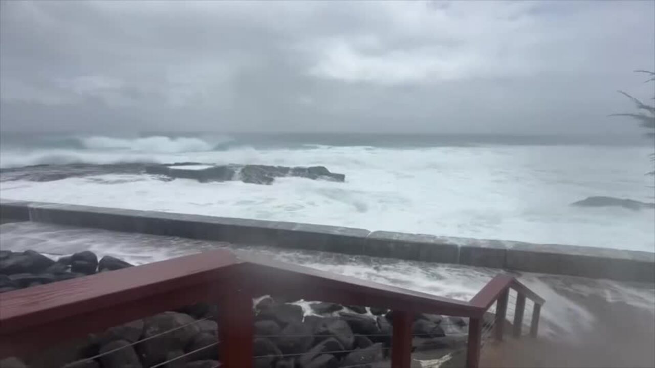
Mr Crisafulli said there had been a wave of around 7m recorded off North Stradbroke Island.
Mr Crisafulli said it was important that Queenslanders did the “little things” to be ready.
“There is still an element of the population that hasn’t yet fully understood the magnitude of this system,” he said.
“And that’s completely understandable because it has been many decades since Queensland has been here in this part of the state (in terms of a cyclone crossing the coast).
“But one thing I know about Queenslanders is they handle disasters better than anywhere else and we’ve proven that time and time again.
“And I know that people in the South East may not have experienced a cyclone before but they’ve been tested with floods and they’ve come through with flying colours every time.”
He confirmed schools would be open on Wednesday.
Mr Crisafulli said people in low-lying areas needed to prepare with storm surge modelling ramping up.
“There is no doubt that there is a potential impact that comes with storm surges,” he said.
“Ultimately the severity of the system, when it crosses, and where it crosses, are all really important factors.
“The modelling that councils are doing at the moment is factoring a storm surge over and above what the modelling is.”
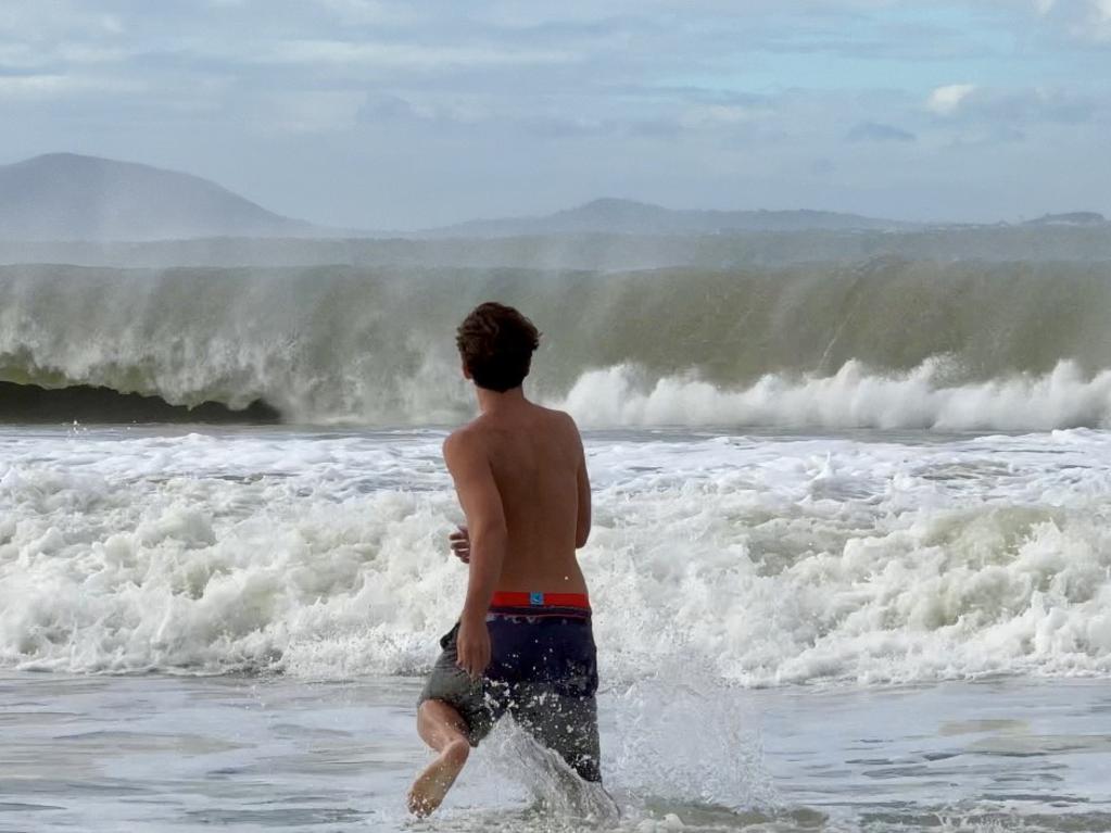
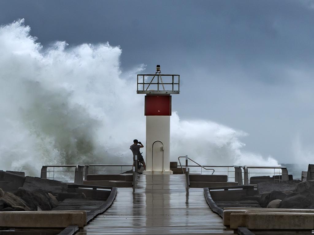
Sky News Meteorologist, Alison Osborne, said waves could “swallow beaches”.
“It’s the waves, so we’re looking at wave heights peaking on Wednesday, evening at between 8 to 10m within the surf zone, so when that comes in, it will swallow beaches,” she said.
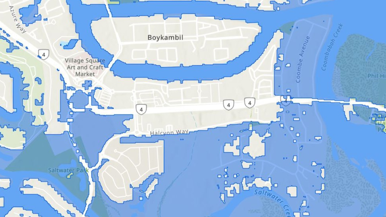
The Gold Coast City Council has warned that up to 6000 properties could have “some form of impact” from rain and a “worst case potential storm surge of 70cm”.
The council has released a new disaster flood risk map showing potential flooding in scores of suburbs from Yatala in the north to Currumbin Valley in the south.
Gold Coast acting mayor Donna Gates said Alfred was shaping as “the most significant system” to hit the Glitter Strip since the “Great Cyclone” of 1954.
“It’s not a good outcome for the Gold Coast and there’s growing concern that Cyclone Alfred is getting stronger as it approaches the coast,” she said in an update on Tuesday afternoon.
“The greatest concern is for the City of Gold Coast as opposed to any other local authorities.”
City of Moreton Bay Council has advised residents all non-essential council services will be paused from 5pm Tuesday.
Waste facilities will be closed from Thursday, while kerbside collection services will be unavailable on Thursday and Friday. Catch-up services will be available for impacted properties from next week, providing conditions are safe.
City of Moreton Bay Council storm surge flood mapping shows the potential of multiple streets and areas being inundated by water, including the bridge from Brighton to Redcliffe.
About 50 homes are forecast to be impacted by potential floor-level flooding. These homes have been doorknocked and residents warned of the looming danger.
The modelling predicts tides 500mm and 800mm higher than the highest atmospheric tide.
Mr Crisafulli said the Port of Brisbane was now closed to freight.
The Bureau of Meteorology was working with the airport to determine if flights will be impacted.
“If passengers are considering changing their flight they should go directly to their airline,” Mr Crisafulli said.
“I’m told the airlines will also be reaching out to some of those passengers.”
Mr Crisafulli said the government had amended regulations to allow supermarket resupply in 21 local government areas to be conducted 24 hours a day.
“That’s never happened before a disaster,” Mr Crisafulli said.
“I want to thank the deputy premier (Jarrod Bleijie) … he has spoken directly with the supermarkets.”
Mr Crisafulli said announcements about public transport would be made in coming days.
He said decisions about pre-emptively shutting off electricity were made by experts.
“One thing is for certain, any pre-emptive decision that’s taken to protect an asset is there to be able to bring it back on sooner.
“They are decisions made by the experts.”
While, the two Gateway bridges will close to all traffic once wind speeds hit 90km/h, Transport Minister Brent Mickelburg’s office has confirmed.
Energex General Manager Kev Lavender denied they would be cutting power and only would in an emergency.
“The reason is, as soon as I turn it off, there’s a process with a follow-up from a safety perspective, where the cyclone comes through or the water rises, we have to go inspect it.
“So if I don’t have to turn it off, I won’t turn it off.”
Mr Lavender said his three priorities were the safety of crews, safety of the public and the protection of the network.
“I’m not going to hurt myself or one of my team. I’m not going to hurt someone in the public, and I’m going to protect the network. So if it’s one of those three things, I’m going to turn the power off. If it’s not one of those things, I’m not interested.”
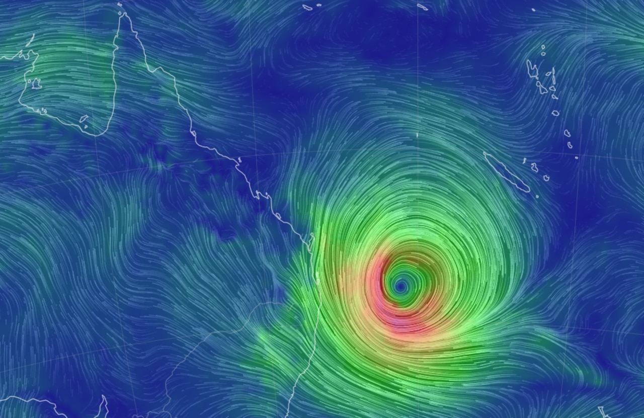
Bureau of Meteorology meteorologist Sue Oates said Cyclone Alfred was 600km to the east of Brisbane and still moving away from the coast.
“However, this should change within the next 24 hours, and we will start to see Tropical Cyclone Alfred stall and then turn on a westward track towards the south east Queensland coast.”

Ms Oates said destructive winds in excess of 95 km/h were expected in the category 2 system, with gusts of more than 130km/h.
She said high winds were expected to be felt from Wednesday afternoon.
“We are expecting gale force winds, with gusts in excess of 90km/h on exposed coastal areas by later Wednesday.”
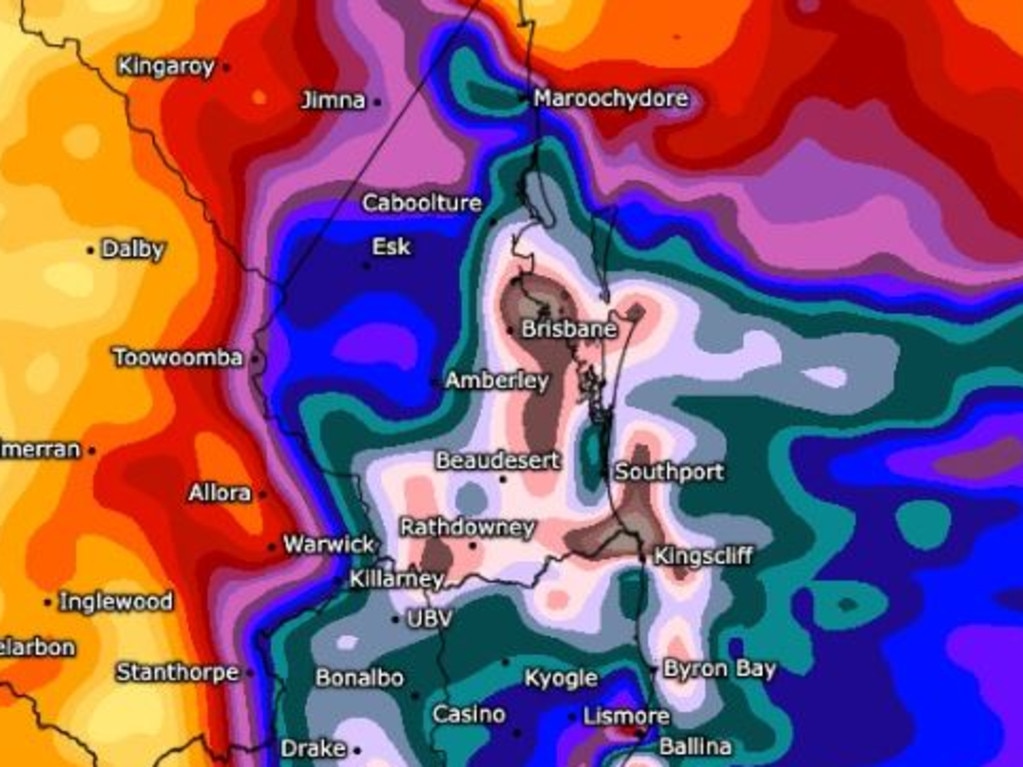
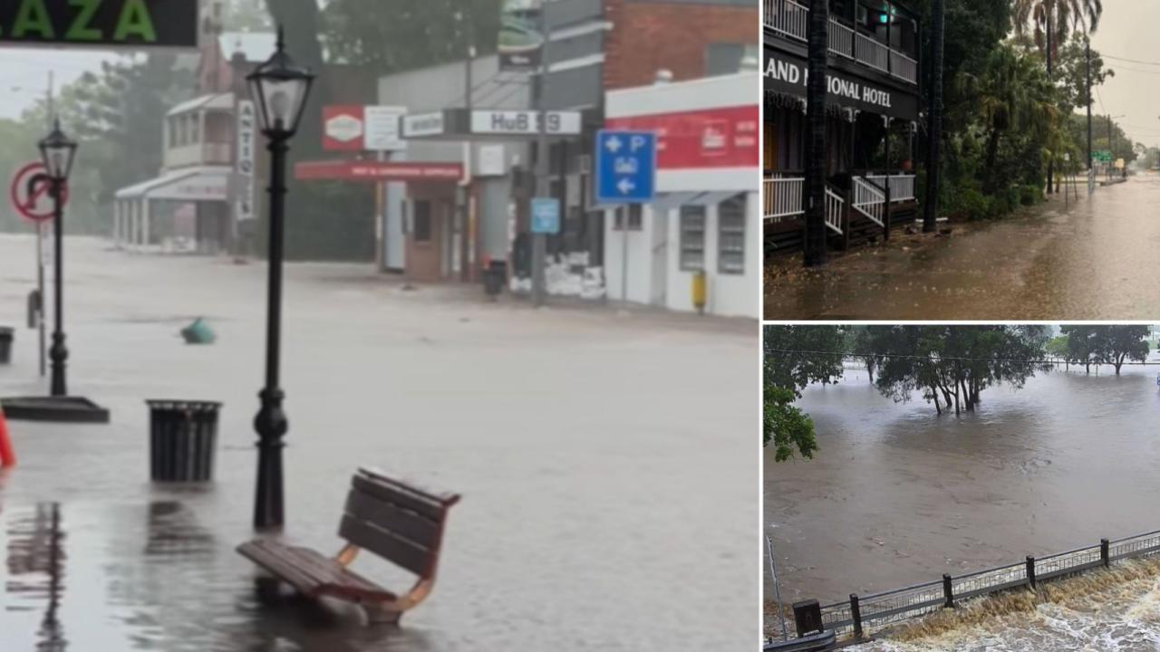
Heavy rain will start to drop on exposed areas of the coastline from Wednesday afternoon, with isolated totals of up to 100mm.
“As Tropical Cyclone Alfred continues to move closer to the coast, that rainfall will move further inland and become more intense and we’re likely to see daily rainfall totals of 200mm-plus, with isolated totals even higher than that – up around 400mm is not out of the question.”
Ms Oates said the rain will set in until Saturday – potentially dropping up to 700mm over three days.
“As you can imagine this is likely to cause riverine flooding through South East Queensland,” she said.
Minor to major flooding was also predicted for catchments in the south east corner.
Ms Oates said at this stage the Bureau was forecasting TC Alfred would cross the Queensland coast as a Category 2 system.
“Appreciating you can’t rule out a more intense system, but the risk of that is very low,” she said.
“We are not seeing that in our modelling and based on the current structure we have identified … it would have a significantly long way to go in its development to get to a Category 3.”
Ms Oates said the impacts would be felt from Wednesday afternoon through to coastal crossing.
“Which at the moment we are anticipating that will be later in the day Thursday if not Friday morning,” she said.
“Once the system does cross the coast, in regards to the sea conditions and the wind conditions, they should ease fairly rapidly.
“But what remains is the rainfall risk and that will continue for a couple of days so we will continue to have a flooding risk right into the weekend.”
Ms Oates said all modelling was showing the cyclone will turn towards Brisbane.
“There’s a total consensus the system will re-curve in the overnight period and make a steady track towards the south east Queensland coast,” she said.
“That’s consistent across all the guidance we are looking at which is over probably seven global models.
“We’ve had further satellite imagery pass over this morning which was a fantastic piece of data that demonstrated to us what the wind profile looks like around the system and it absolutely confirms we have a category 2 system out there.”
Ms Oates said tides could be 0.5m to 0.8m higher than the “highest astronomical tide”.
Ms Oates said the cyclone will cause some of the highest tides of the year Wednesday night into Thursday morning.
Ms Oates said the cyclone looks to be approaching the coast Thursday into Friday morning.
Queensland Fire Department has requested resources from North Queensland, including a semi-trailer full of motorised rescue equipment.
A large cohort of swift water rescue crews were also being deployed from Maryborough to the border.
SES has moved 70 volunteers from all parts of the state to the southeast corner.
In the last 24 hours, there have been more than 800 requests for assistance from Queenslanders.
The update from the Bureau, the Premier and authorities came as the AFL announced it would postpone both opening round matches scheduled for Queensland.
Brisbane Lions were scheduled to host Geelong at the Gabba Thursday night and Gold Coast were to take on Essendon Saturday on the Gold Coast.
Island residents must decide today whether to stay or go
Acting Commissioner Shane Chelepy said island residents needed to make a decision today on whether they would evacuate or remain in their homes.
“The worst time to make the decision to leave is when we’re in the middle of an event,” Mr Chelepy said.
Mr Chelepy said voluntary evacuations were occurring on South Stradbroke Island and authorities were doorknocking at-risk areas on the Sunshine Coast and Brisbane bay areas.
Police have pre-deployed 255 police to Sunshine Coast and Gold Coast areas to help doorknock.
Premier David Crisafulli said passenger ferry services to island communities would stop today and evacuations were currently occurring.
“People who live on those islands, please absorb the message, make a decision about your welfare and do everything you can to stay connected.
“A number of evacuations are occurring for vulnerable people, so doorknocking is taking place at the moment.”
Gold Coast City Council is urging dozens of residents on South Stradbroke Island to evacuate, with a barge leaving the island on Tuesday afternoon.
But many of the 40-plus residents of Couran Cove – who are living off-grid after water, power and sewage was cut off last year amid a bitter body corporate dispute – are staying put as Cyclone Alfred bears down.
The council is also warning residents in other low-lying areas to prepare for flooding and potential evacuations.
But many unwavering long term Couran Cove residents, who have lived off grid without essential services for nearly two years, have rejected evacuation orders ahead of Cyclone Alfred.
“The people that are staying have been in many cyclones before – the Whitsundays and Darwin,” said Paul Wilson, a resident of nine years.
“A Category 2 is like a stiff breeze.
“Unless it gets to 200km/h Category 4, we’ll bunker down.”
Bin collection cancelled
Logan, Brisbane, the Gold Coast and Ipswich councils will not collect bins on Thursday or Friday. Services are to resume as normal next week.
‘It’s going to get wild’
Community storm chaser Higgins Storm Chasing said Alfred had 100 per cent locked in that tropical cyclone Alfred will hit the South East Queensland coast late on Thursday to early Friday.
“Alfred will start to track west tonight and keep going west across the coast and well inland until Saturday,” it said on Tuesday.
“It could intensify slightly just before landfall, l with destructive winds to 150km/hr on the western and southern side of the centre.”
Higgins said a bulk of very heavy rain from the southern part of the system will smash the southeast Queensland coast into the northeast New South Wales, prompting flooding.
It also predicted huge surf that causes coastal erosion and inundation of the low lying foreshore early Friday morning.
“It is going to get pretty wild from early Thursday so use the next few days to prepare,” it warned.
Weatherzone’s Anthony Sharwood said up to a metre of rain was possible over elevated ranges and hinterland locations in South East Queensland and northeast New South Wales.
The Bureau of Meteorology said that as of 10.45am on Tuesday, Alfred was 630km east of Brisbane, moving south-southeast at 13km/h.
“Alfred’s intensity may fluctuate between category 1 and 2 later today and tomorrow, but it is forecast to cross the southeast Queensland coast at category 2 strength late on Thursday or early Friday,” the Bureau of Meteorology said in its 11am bulletin on Tuesday.
Senior Meteorologist Jonathan How, speaking on Tuesday morning, said gale force winds were expected to develop over the next 24 to 48 hours for residents in the Sunshine Coast, Brisbane, Gold Coast and Byron Bay and Northern Rivers communities.
“Over the next few days we will see Tropical Cyclone Alfred move closer to the South East Queensland coast. Into Thursday we will see it come very close to the coast, at this stage we are expecting it to make a crossing and landfall anything from late Thursday and into Friday,” he said.
Mr How said landfall was still expected between Sunshine Coast and Brisbane but residents in the southern flank would feel the worst impacts of the cyclone.
“The location of landfall is critical as we are expecting the worst of the impacts or most significant impacts on the southern flank of the cyclone. That does include places like Brisbane, Gold Coast and also Northern Rivers,” he said.
Mr How said destructive and sustained winds over a long period of time could lead to significant property damage.
Cancellations and closures
Live Nation has confirmed tomorrow’s Green Day concert on the Gold Coast has been cancelled.
“We understand the immense disappointment surrounding the cancellation of tomorrow’s Green Day show on the Gold Coast due to Cyclone Alfred,” the tour promoter posted on Facebook.
“This decision was made in close consultation with local authorities and with Green Day, prioritising the safety of all involved.”
Live Nation said it was not possible to reschedule the show to a later date due to the band’s international tour schedule and refunds would be processed to the original method of payment within 14-21 days.
It comes as this weekend’s scheduled Mooloolaba Triathlon has also been cancelled, organisers have announced.
“After consultation with stakeholders the Mooloolaba Triathlon team has made the decision to not go ahead with the event,” it told competitors in an email.
“The safety of athletes, supporters, the community, volunteers and staff are first and foremost when making this decision, including the safety of travel to and from the event.
The team is working closely with all stakeholders to secure a new event date, and we will communicate directly with you with further information as soon as possible.”
Meanwhile all Gold Coast theme parks and attractions will close for at least three days from Wednesday to Thursday.
Multiple restaurants have also posted to social media that they will close their doors for at least three days.
Economic impacts of TC Alfred
Federal Treasurer Jim Chalmers on Tuesday said the economic impacts from Tropical Cyclone Alfred were unclear and the focus was on the safety of those in the firing line.
The federal government had pre-positioned three heavy lift helicopters in Queensland and New South Wales if they are required.
“We’re focused on the human cost, not the economic cost. Of course there will be an economic cost when all is said and done, but the sole focus of all levels of government is to make sure we are ready, we are prepared,” Mr Chalmers said.
“It’s going to be an anxious wait this week as we wait for the cyclone to cross the shore.
“We’ve been briefed this morning at all three levels of government … all three levels of government will be there for you as well.
“We are all bracing for the heavy weather. We are prepared for the worst but we hope for the best.”
Asked about the yet to be announced federal election date, Mr Chalmers said it couldn’t be further from his mind.
“The Prime Minister will call the election sometime in the next couple of months, that’s a matter for him in consultation with his colleagues.
“I’m not going to get into private conversations with the Prime Minister about these sorts of things.”
Premier, Mayor urge residents to prepare
Mr Crisafulli urged residents in the warning area – which stretches from K’gari/Fraser Island south to Grafton in Northern NSW – to use the next couple of days to prepare.
“We are putting all the preparations in place and we are asking all Queenslanders to do the same,” Mr Crisafulli said.
“We are dealing with a very heavily populated part of the state … that hasn’t seen a cyclone for many years, in fact many decades.”
He said it was still unknown where exactly Alfred would make landfall.
“Now exactly where it crosses the coast at exactly what time and the severity remains a bit of a grey area,” he told 612 ABC Radio Brisbane.
“What isn’t in question from all of the modelling from BOM is that it will cross the coast.
“The system intensified overnight to a category 2, which we were expecting that do.
“At this stage that window is somewhere a little north of Noosa through to somewhere a little south of the border, so it has tightened a bit, likely to be the Bureau is saying somewhere in that order of Thursday or Friday.”

Mr Crisafulli added he had requested councils to run their modelling in the event TC Alfred crossed on the high tide, so people residing in low-lying areas could prepare adequately.
“Whether it crosses on the high tide makes a big difference,” he said.
“You can then relay that information to people, people need information to make a decision.”
All Brisbane City Council bridges will close when the wind reaches 90km\h, Infrastructure committee chair Councillor Andrew Wines announced on Tuesday morning.
That included the green bridges at Kangaroo Point and Breakfast Creek and the Go Between Bridge.
It is not known if the state government will close its bridges.
A spokeswoman said closures would depend on Bureau measurements and engineering advice.
An unearthed government report suggested more than half-a-million homes could suffer damage if Tropical Cyclone Alfred makes landfall as a category 2 system.
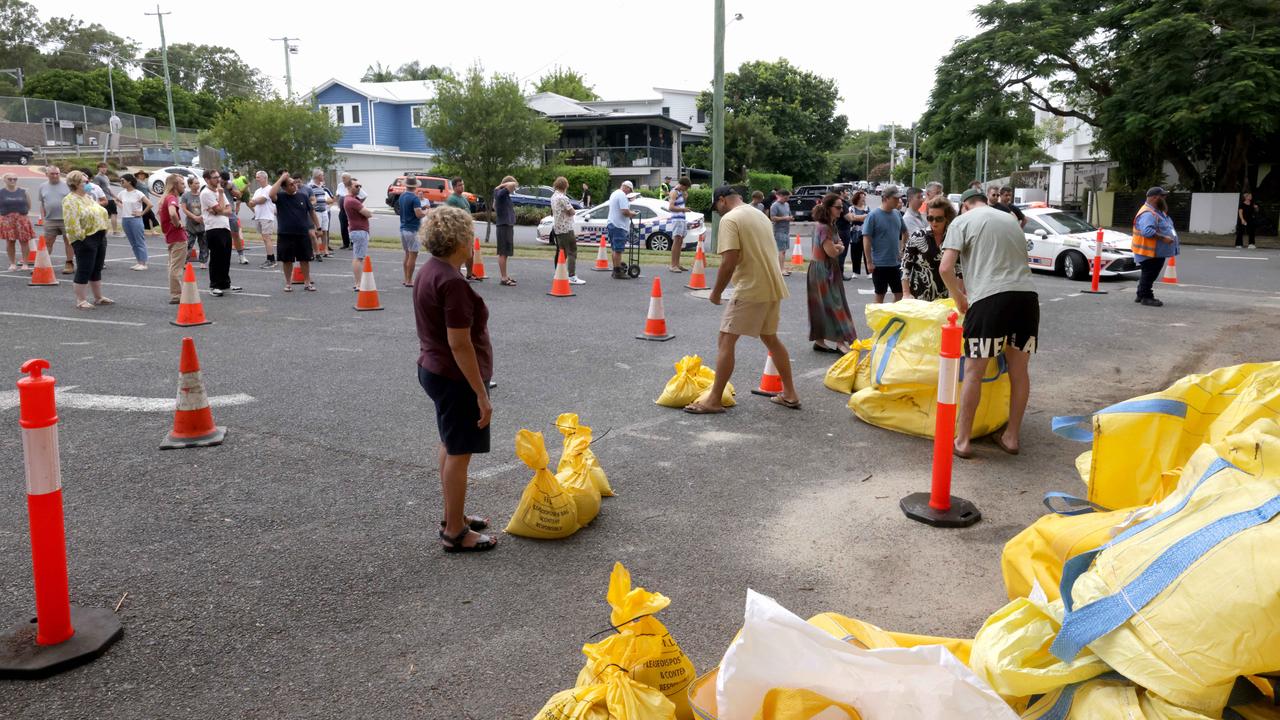
Sandbagging stations run out
Residents preparing for Cyclone Alfred on Tuesday morning had already begun to wait several hours at sandbagging stations.
Mr Schrinner said 74,000 sandbags were supplied in Brisbane on Monday.
“To put in perspective, in the 2022 flood, which was obviously a devastating natural disaster, the maximum supply in one day was 37,000. So we’ve had demand that’s been off the charts,” he said.

People waiting in queues with their cars have said they had been in a line at the Morningside sandbagging station since 5am.
At 8.30am, the site ran out of sandbags, with residents told to return in two hours.
The same thing happened at Newmarket on Monday. On Tuesday morning there were dozens of cars waiting at the Newmarket site.
Federal Aged Care Minister Anika Wells blasted Brisbane City Council for not having enough sandbags on hand for residents trying to protect their homes.
Ms Wells said she was working with local and state counterparts and council had been caught “short”.
“I think one of the lessons out of the 2022 floods was that we should have 150,000 sandbags in the city at any time where they need to be deployed,” she said on 4BC.
“And they were not ready, they were not ready.”
Ms Wells said some residents have been queuing overnight in a bid to get sandbags.
“Locals have told me that they have been in to collect them overnight and when people have gone in at sunrise this morning they weren’t there. Now there is a big queue.”
Residents who heading to sandbag stations are advised to bring their own shovel and zip ties as operations continue.
Redland City Council said at noon on Tuesday that 16,200 sandbags had been distributed in the area, and bags were currently running low.
“Across yesterday, 9200 bags were distributed to the mainland stations at Redland Bay and Capalaba, adding to the more than 7000 distributed over the weekend,” a spokesman said on Tuesday.
He urged the community to be patient as stations experience high demand.
“Council is also expecting a large shipment of sandbags from interstate this afternoon which will be distributed to all sites across the city,” he said.
“Any sandbags residents may have stored away from a previous weather event should be reused if they are in good condition.
“The community is reminded that there is a limit of 10 sandbags per vehicle, per trip and enclosed shoes must be worn at all times. Bring your own shovel.”
The Redlands council currently operates sandbag stations across Capalaba, Redland Bay, Thornlands, Dunwich, Russell Island, Macleay Island, Lamb Island and Coochiemudlo Island.
Call to supermarkets to keep shelves stocked
Premier Crisafulli said he understood – and even encouraged – people to buy the essentials they might need should water and power be cut for a sustained period after the cyclone hits.
“It is important that people have sufficient food and water and I understand why Queenslanders want to do that, that is important,” Mr Crisafulli said.
He called on the major supermarkets to do what they could to keep their shelves stocked, and both Coles and Woolworths confirmed plans were in place to ensure the stores could be restocked.
Energex regional field delivery general manager Kev Lavender said residents should be prepared to go without power for days without power.
Mr Lavender said there were 1000 staff on standby in South East Queensland as per standard operating protocol, but with hundreds more staff from outside the region are ready to be deployed.
“We are looking at our restoration plan no matter whether it hits north of Brisbane, south of Brisbane, we do understand that the first power outages will probably come from the high winds, and then, what does that look like, from the rain that comes through,” Mr Lavender said.
Customers who rely on electrical medical equipment or temperature-controlled medication were warned to have a backup plan such as a generator, the ability to check in with a local hospital, or find someone with power to stay with.
They are advised to charge everything they own, to fill barbecue and cooking gas bottles, and to fill bathtubs if reliant on pumped water.
He said that while it was too early to tell the length of outages, residents should prepare for at least three days without power.
But he said: “Energex has been preparing for Cyclone Alfred since last week and the community can rest assured that we’re ready to respond to anything Mother Nature throws at us.”
The first residents to feel the impact of the cyclone will be the region’s island communities, including Bribie, Stradbroke, Moreton, and those in the Bay.
They were told to decide by Tuesday morning whether to leave or bunker down, with damaging winds expected to be felt by Wednesday and passenger ferry connections to the mainland to stop on Tuesday.
Mr Crisafulli said there would be three stages to the weather event – big surf and erosion, damaging winds, and then likely flooding.
He said the immediate priority was therefore those island and other low-lying communities, including canal suburbs – which could be impacted by significant storm surges.
He also said there was a very strong likelihood schools would be closed later in the week, but that those decisions would be made at least the day before. No schools would be shut on Tuesday.
Queensland University of Technology announced it was shifting all classes online from Wednesday to Friday.
It came as all CityCat and ferry services on the Brisbane River were suspended overnight until further notice, so the vessels could be moved to safety.
Queensland Rail and commuter bus services were still running. Any changes would be shared with commuters.
A flood watch has been issued for areas from around the Bundaberg area south to the border – including catchments from the Mary River, through the Sunshine Coast rivers, the Brisbane River catchment, and down to border catchment areas of the Logan and Albert Rivers.
The State Emergency Service had received 450 requests for help since last week but were already preparing to move personnel to communities predicted to be hardest hit.
Marine Rescue Queensland has also deployed 22 vessels along the coastline to respond if needed.
With millions of people in the firing line, the government has also met with telecommunications companies to speak to them about providing extra capacity to put emergency messages out.
Both Coles and Woolworths assured they were working to ensure stores were stocked.
“We have extra deliveries on the roads already, with a focus on boosting our supply of meat, milk, bread, water, canned goods, baby formula and toilet paper,” a Coles spokesman said.
More Coverage


Originally published as Cyclone Alfred: SE Qld residents to brace for power outages, service shutdowns
Join the conversation
Move to higher ground: Brisbane emergency alert, dangerous storm incoming, 145mm in 3 hours
Residents in one part of Brisbane have been told to prepare to move to higher ground as the dangerous aftermath of ex-Tropical Cyclone Alfred continues, with emergency alerts also issued north and west of the city, major flood warnings in place and a severe storm warning current. LATEST
Read more
‘Take shelter now’: Lockyer Valley braces for dangerous flooding
Lockyer Valley Regional Council has issued an emergency warning to ask residents to take shelter due to flooding from ex-Tropical Cyclone Alfred.
Read more