
Sydney braces for more storms as severe weather brings flood rescues, power outages and heavy rain
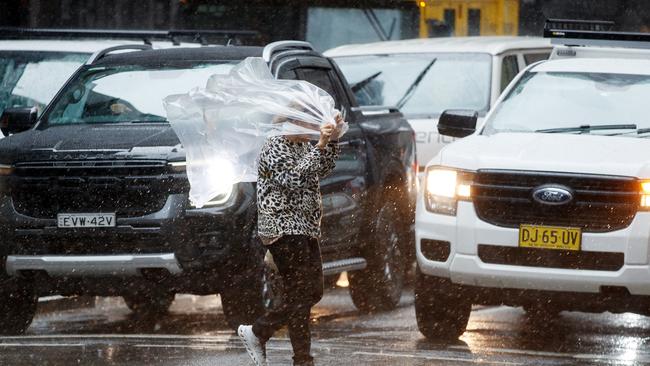
Sydney is bracing for more storms after severe weather brought lightning, large hailstones, and heavy rain, leaving thousands without power.

NSW
Don't miss out on the headlines from NSW. Followed categories will be added to My News.
More wet weather is expected to hit Sydney after severe storms caused significant disruptions, affecting both flights and public transport.
The storm system brought lightning strikes and large hailstones to homes in the western suburbs, while a dramatic shell cloud appeared over the city’s east.
Around 4000 homes lost power for several hours as trees were brought down by the storm, with outages reported in Greenacre, Hurstville, Freshwater, Curl Curl, North Manly, Brookvale, Bexley and Kingsgrove, according to Ausgrid. By 8.30am on Tuesday, power had been fully restored to all impacted regions.
Senior Meteorologist Christie Johnson said more rain and storms are likely.
“As we go through the next few days there’s actually going to be a risk of storms across NSW right through until the weekend, easing on the weekend but right through the rest of the week,” she said.
The Bureau of Meteorology predicts Sydney faces potentially four more days of rain, before it clears on the weekend.
There’s a medium chance of rain on Tuesday, before a high chance of showers on Wednesday. There’s a very high chance of rain on Friday, with up to 10mm predicted.

State emergency services received 76 calls for assistance across Sydney, including three flood rescues, after 30mm of rain soaked parts of the city, with the inner west bearing the brunt of the downpour.
“All flood rescues involved vehicles in water, where crews rescued drivers in Eastgardens, Homebush, Strathfield and Croydon Park,” a spokesperson from SES said on Tuesday.

Sydney is set to receive up to 3mm of rain on Tuesday, with heavier showers increasing to 9mm by Wednesday.
In the space of an hour on Monday afternoon, the severe cell battered parts of Sydney with strong winds, heavy rain, flash flooding and up to 3000 lightning strikes, according to the Bureau of Meteorology, who warned residents to stay indoors as the storm rolled through.


In Gladesville, Ausgrid workers and fire crews were working into Monday night, frantically trying to remove a giant tree, which took out powerlines in the afternoon.
The tree blocked off Ashburn Place and almost 200 residents in the area were without power as of 9pm.
Earlier on Monday, a severe thunderstorm warning was issued for Sydney, as the city faces days of wet weather.

While the storm moved offshore as quickly as it had arrived, BOM Meteorologist Christie Johnson warned Sydneysiders the cell was the start of what could be the start to a wet week.
“We are expecting this thunderstorm outbreak to last until the end of the week,” Mrs Johnson told The Daily Telegraph.
“The risk is lowered for this evening and Tuesday, but there are more storms potentially coming on Wednesday and will last till Friday.”

The heaviest rainfall was in Allambie on the Northern Beaches, which recorded 30mm in just half an hour, while Marrickville in the Inner West received 27mm and Lake Illawarra had 18mm fall in just 10 minutes.
Several areas in Sydney were issued a warning early on Monday afternoon, relating to the storm.
“NSW SES advises residents in Gosford, Sydney, Penrith, Parramatta, Campbelltown & Taralga to MONITOR CONDITIONS for forecast HEAVY RAIN. Avoid unnecessary travel, secure outdoor items, and have your emergency kit ready,” NSW SES tweeted.
Sky News Australia meteorologist Alison Osborne said a high pressure system over the Tasman Sea and a trough across the inland east combined forces on Monday, causing severe storms across Sydney and parts of NSW.
“Meanwhile, a frontal system crossing the southeast will help to create the perfect environment for showers and thunderstorms to develop across much of New South Wales,” Ms Osborne said.
Good storm hitting Sydney pic.twitter.com/UAm1eh7MUN
— AJP (@pricey43) October 14, 2024
A NSW Fire and Rescue spokesman said they had received a few calls for assistance but “nothing out of the ordinary.”
“There are some reports of tree branches falling, but lots of little nuisance jobs.”
At one point on Monday afternoon, the SES were attending to 34 jobs around Sydney, with three active flood rescues taking place in Sydney’s Inner West.
“There are three active flood rescues in Strathfield, Croydon and Homebush,” a NSW SES spokesman confirmed to The Daily Telegraph.
“Majority of our call outs are storm related situations, but most have been routine.”
The SES confirmed later in the night there was a rescue operation underway in Eastgardens, in the city’s east.
Even after the conditions eased, both the BOM and SES warned the chance of severe weather redeveloping was a possibility.
A video sent to The Daily Telegraph just after 3.30pm showed a section of Parramatta Rd in Camperdown was partially flooded.
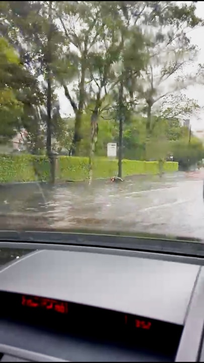
The footpath outside of Sydney University is underwater, with water from the road flowing heavily onto the side of the street.
A large black storm cell is also hovering over Caringbah South.
Sutherland Shire resident Taine, has described the cell as “very disturbing” and said others in the area felt the same.
“We’ve had heavy rainfall from around 3pm this afternoon,” Taine said.
“No damage to the property, just a downpour of rain at once.”
More to come

Originally published as Sydney braces for more storms as severe weather brings flood rescues, power outages and heavy rain

Payne Haas: Footy, family and my life as a Bronco
Payne Haas is still young but carries heavy burdens on and off the football field. From family heartache to NRL stardom, this is the story of his rise. SPECIAL REPORT
Read more

NSW in firing line for more severe storms today
Sydneysiders are bracing for a repeat of Monday’s intense weather as a low pressure trough is set to cause further chaos this afternoon. More details.
Read more