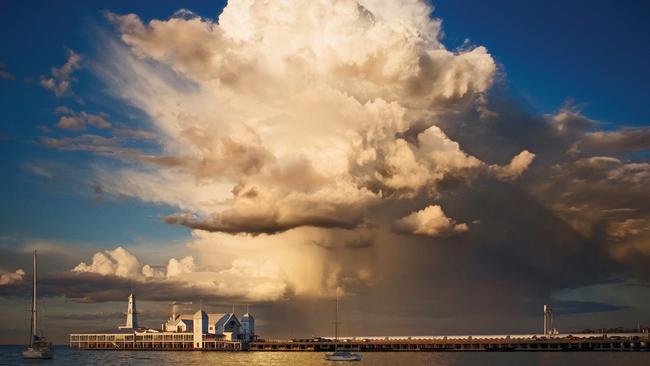
1/17Australian Weather Calendar 2015 available online at http://shop.bom.gov.au: Melting frost on dandelion, Kambah, Australian Capital Territory. Photograph: Debbie Hartley Photography. When she lived in Kambah, ACT, Debbie Hartley took a camera out into her back yard early each morning, ‘because overnight anything can happen’. On 1 May 2011 she found a dandelion sparkling with frost. ‘When the sun comes up,’ says Debbie, ‘you’ve got to start photographing really quickly or you’re going to miss it all.’
Australia’s most incredible weather pictures
2/17January: Lenticular cloud over Mount Macedon, Victoria. Photograph: Cathy Newing. Weird shapes in a lenticular cloud above Mount Macedon, Victoria distracted Cathy Newing’s botanical art class in May 2010. ‘Everyone just stood outside and watched it,’ says Cathy. She happened to have her Caplio R7 camera in her handbag, and caught the cloud in a series of shapes, including this bird-like profile. ‘It was in that particular shape for probably only for less than five minutes,’ Cathy recalls, ‘and it was changing all the time.’ .
3/17February: Explosive convection east of Warwick, Queensland. Photograph: SE Qld Weather Photography by Chris McFerran. Chris McFerran drove east from Warwick, Queensland, to watch a storm brewing on the other side of the Great Dividing Range in December 2013. From his viewpoint, says Chris, ‘we see the top two thirds of the thunderstorm; we don’t actually see the base’. East of the mountains, in the path of the storm, 4.5 cm sized hail was reported near Boonah around the time Chris took his photo.
4/17March: Aurora australis over the Hazard Mountains from Coles Bay, Tasmania. Photograph: Ben Fewtrell. An alert on his tour guide’s phone while in Tasmania told Ben Fewtrell he might get to see the aurora australis, or southern lights. ‘Well that was an opportunity I wasn’t going to say no to,’ says Ben. Most of the tour group at Coles Bay that night were driven away by rain, but Ben stayed until the sky cleared.
5/17April: Funnel cloud north of Cooma, New South Wales. Photograph: Lucy Stevenson. When 25-year-old Lucy Stevenson spotted a long, twisting cloud from the Monaro Highway just north of Cooma on Boxing Day 2013, she didn’t know what it was. She snapped a picture on her iPhone, out of the window of her brother’s moving car, and posted it on Twitter. Lucy soon had her answer: It was a funnel cloud, created when water vapour in the air is condensed into droplets by rapidly rotating winds.
6/17May: Storm front over Muirhead, Northern Territory. Photograph: Louise Denton Photography. ‘In Darwin we’re pretty spoilt with storms,’ says Louise Denton. ‘A lot of them are quite isolated, so you can stand and watch them go straight past.’ She drove to Darwin’s northern edge to photograph one such storm—capturing a shelf cloud, a cumulonimbus and a bolt of lightning.
7/17June: Frost and cushion plants on Skullbone Plains, Tasmania. Photograph: Rob Blakers. Rob Blakers was up early on 5 April 2011 to photograph cushion plants and frost-covered grasses on Skullbone Plains. The 1600 ha property in central Tasmania joined Australia’s National Reserve System in 2011. When a solid surface is colder than freezing and also below the ‘dew point’ of surrounding air, moisture is deposited on it as frost.
8/17July: Isolated heavy rain over the Kennedy Range, Western Australia. Photograph: Jordan Cantelo. Jordan Cantelo was an air observer for the WA Department of Environment and Conservation during bushfires in early 2012. ‘When I was flying back along the Kennedy Range some thunderstorms fired up,’ he recalls, ‘and provided the most magnificent view for us from the helicopter’.
9/17August: Fog covers the desert near Kati Thanda – Lake Eyre, South Australia. Photograph: Peter Elfes Photography. In 2012 much of Australia’s semi-arid interior was recharged by floodwaters from Queensland. Water in Kati Thanda – Lake Eyre, usually a salt pan, provided moisture for the fog in Peter Elfes’ photograph. ‘So much water in an area that normally doesn’t have it,’ he says, ‘creates weather situations that you don’t normally get to see.’
10/17September: Roll cloud over first leg of Sydney to Hobart yacht race, New South Wales. Photograph: ©ROLEX / Carlo Borlenghi. In over 30 years following yacht races around the world, Carlo Borlenghi has only seen two roll clouds—one in Sardinia, west of Italy, in 2008; and this one, preceding a southerly buster on the first leg of the 2010 Sydney to Hobart race.
11/17October: After a brief hailstorm in Geelong, Victoria. Photograph: Peter Marin Photography. Peter Marin waited out a hailstorm in his car on the Geelong waterfront, then walked up Western Beach to see ‘what kind of light was going to be produced’ in the wake of the storm. ‘The sun, which was behind me, was starting to shine through a gap in the clouds,’ says Peter. ‘This lit up the main storm cloud, which was looking pretty spectacular. Right time, right place.’
12/17November: Kelvin-Helmholtz wave cloud over Jervis Bay, New South Wales. Photograph: Giselle Goloy. The wave-shaped clouds in Giselle Goloy’s photograph are a result of Kelvin-Helmholtz instability. Lighter, warmer air lying over denser, colder air forms two separate layers, and different wind speeds in each layer cause rippling at the boundary. The effect is similar to a flag flapping, caused by differences in wind speed on either side of the cloth.
13/17December: Lightning over Adelaide Airport, South Australia. Photograph: Rowland Beardsell. A night shift at Adelaide Airport Met Office in March 2013 let Rowland Beardsell combine his job as a Bureau of Meteorology weather observer with his passion for storm photography. A thunderstorm was expected so he set up his camera on the Met Office balcony with a timer set to begin a new exposure every 20 seconds. While working, he saw a bright flash and raced out,’ he says, ‘and sure enough there it was on the camera’—he had captured not one lightning bolt, but three simultaneous strikes.
14/17MUST NOT PUBLISH ON ANY PLATFORM UNTIL NOVEMBER 5TH 2014 ***HEAVY FEES APPLY IF USED PRIOR TO AGREED DAY*** PLEASE CREDIT PHOTOGRAPHER AND ACCOMPANY WITH EDITORIAL COVERAGE OF THE CALENDAR October After a brief hailstorm in Geelong, Victoria. Photograph: Peter Marin Photography Peter Marin waited out a hailstorm in his car on the Geelong waterfront, then walked up Western Beach to see ‘what kind of light was going to be produced’ in the wake of the storm. ‘The sun, which was behind me, was starting to shine through a gap in the clouds,’ says Peter. ‘This lit up the main storm cloud, which was looking pretty spectacular. Right time, right place.’ Hail forms when very cold water droplets within a cloud freeze. The resulting ice particles circulate in the cloud and grow as more water freezes onto them. Strong updrafts within severe storms can allow this process to continue until large hailstones are formed. Peter used a Canon EOS 30D camera, at a focal length of 17 mm.
15/17MUST NOT PUBLISH ON ANY PLATFORM UNTIL NOVEMBER 5TH 2014 ***HEAVY FEES APPLY IF USED PRIOR TO AGREED DAY*** PLEASE CREDIT PHOTOGRAPHER AND ACCOMPANY WITH EDITORIAL COVERAGE OF THE CALENDAR October After a brief hailstorm in Geelong, Victoria. Photograph: Peter Marin Photography Peter Marin waited out a hailstorm in his car on the Geelong waterfront, then walked up Western Beach to see ‘what kind of light was going to be produced’ in the wake of the storm. ‘The sun, which was behind me, was starting to shine through a gap in the clouds,’ says Peter. ‘This lit up the main storm cloud, which was looking pretty spectacular. Right time, right place.’ Hail forms when very cold water droplets within a cloud freeze. The resulting ice particles circulate in the cloud and grow as more water freezes onto them. Strong updrafts within severe storms can allow this process to continue until large hailstones are formed. Peter used a Canon EOS 30D camera, at a focal length of 17 mm.
16/17MUST NOT PUBLISH ON ANY PLATFORM UNTIL NOVEMBER 5TH 2014 ***HEAVY FEES APPLY IF USED PRIOR TO AGREED DAY*** PLEASE CREDIT PHOTOGRAPHER AND ACCOMPANY WITH EDITORIAL COVERAGE OF THE CALENDAR Australian Weather Calendar 2015 Cover Melting frost on dandelion, Kambah, Australian Capital Territory. Photograph: Debbie Hartley Photography When she lived in Kambah, ACT, Debbie Hartley took a camera out into her back yard early each morning, ‘because overnight anything can happen’. On 1 May 2011 she found a dandelion sparkling with frost. ‘When the sun comes up,’ says Debbie, ‘you’ve got to start photographing really quickly or you’re going to miss it all.’ Debbie was using a Canon 7D camera with a 100mm macro lens. The sea, which takes a long time to heat up or cool down, moderates coastal climates and keeps them warmer in winter. The ACT, though, lies inland of the Great Dividing Range, 150 km from the coast. It has a relatively dry continental climate and gets very cold in winter. The plains of Russia and central North America also have continental climates. Contact the photographer media@bom.gov.au
17/17MUST NOT PUBLISH ON ANY PLATFORM UNTIL NOVEMBER 5TH 2014 ***HEAVY FEES APPLY IF USED PRIOR TO AGREED DAY*** PLEASE CREDIT PHOTOGRAPHER AND ACCOMPANY WITH EDITORIAL COVERAGE OF THE CALENDAR October After a brief hailstorm in Geelong, Victoria. Photograph: Peter Marin Photography Peter Marin waited out a hailstorm in his car on the Geelong waterfront, then walked up Western Beach to see ‘what kind of light was going to be produced’ in the wake of the storm. ‘The sun, which was behind me, was starting to shine through a gap in the clouds,’ says Peter. ‘This lit up the main storm cloud, which was looking pretty spectacular. Right time, right place.’ Hail forms when very cold water droplets within a cloud freeze. The resulting ice particles circulate in the cloud and grow as more water freezes onto them. Strong updrafts within severe storms can allow this process to continue until large hailstones are formed. Peter used a Canon EOS 30D camera, at a focal length of 17 mm.