
Cairns weather: Heavy rainfall and flood warning as towns cop over 100mm
While severe weather warnings remain in place for the Far North, the Bureau of Meteorology has explained why the region hasn’t received the forecast 300mm, and what’s in store when the system intensifies over the weekend.

Cairns
Don't miss out on the headlines from Cairns. Followed categories will be added to My News.
UPDATE FRIDAY 2PM: A SLOW-MOVING surface trough is making it harder for meteorologists to forecast, but there is one guarantee – the Far North won't be seeing a whole lot of sunshine this weekend.
Warnings of rainfall totals up to 300mm weren’t experienced anywhere along the Far North coast, with Mareeba receiving only 5mm on Thursday. However BOM meteorologist Brooke Pagel said the trough was moving slower than expected.
“It’s just shifting offshore,” Ms Pagel said.
“We were thinking it may have drifted a little bit more onshore on Thursday, but it’s remained offshore so the heaviest of falls had been those coastal fringes rather than spreading inland.”
The Bureau’s initial forecast had triple-figure rainfall totals forecast for much of the Far North coast on Friday, however at midday, no gauge in the Cairns Regional Council area had received above 50mm, while in the Cassowary Coast Upper Murray Rd near Tully had recorded 61mm.
Ms Pagel said most of the heavy falls had been from the Mission Beach area down to Townsville, but it was expected the trough would move north over the weekend.
“The latest modelling had a strong signal saying that the rain would ease off on Saturday, but still up to 70mm, but from Monday it’s really going to ramp up again, looking potentially up to 120mm.
“We’re seeing the trough move north of Innisfail on Saturday, so whether that’s going to interact with another system next week and cause those heavy falls, or that might be the potential of it shifting it back south as well. But it is sticking around.”
Ms Pagel said a weakening La Nina system meant the current weather event wouldn’t be the last of the “late wet season.”
“So we still are expecting above average rainfall and above average temperatures over the next few weeks.”
A Cairns Airport spokesman said on midday Friday staff had been monitoring the weather situation which at the time was “calm” while the heavier conditions “appeared to be further south.”
He said no flights had been cancelled as a result of the weather.
“We’re constantly monitoring the weather, but from a passenger perspective, their airline would be their normal point of contact if there’s any change to their flight,” he said.
The rainfall which hasn’t had “out of the ordinary” impacts on Cairns, had also left tour operators unscathed with a Cairns Marlin Marina spokesman confirming on Friday “it was business as usual” for all the boats.
FAR NORTH RAINFALL TOTALS FROM 9AM TO 2PM, APRIL 22
Cairns Airport - 2.6mm
Gordonvale - 1mm
Clyde Rd (Babinda) - 32mm
Saltwater Creek (Innisfail) - 50mm
Mourilyan Mill - 46mm
Upper Murray Rd (Tully) - 61mm
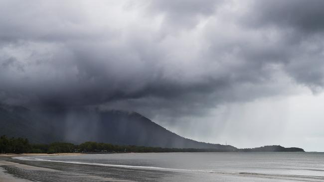
UPDATE FRIDAY 7AM: THE Bureau of Meteorology in it latest severe weather update on Friday is warning of heavy rain including six-hourly totals of up to 300mm for parts of the Far North.
The latest forecast predicted a surface trough to deepen and remain slow-moving today leading to an enhancement of moist and unstable onshore flow, before shifting north of Cairns early on Saturday.
“Uncertainty exists whether the trough will move back onshore and produce widespread heavy rainfall with locally intense falls,” the update read.
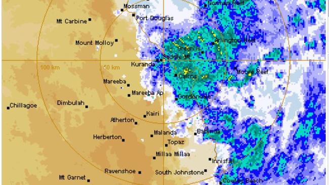
“Although a decreasing threat, localised intense rainfall leading to dangerous and life-threatening flash flooding remains possible during this period with six-hourly totals up to 300mm.
“A separate severe thunderstorm warning will be issued if very dangerous thunderstorms with intense rainfall are detected.
“A flood watch is current for coastal catchments from the Whitsunday Islands to the Daintree.”
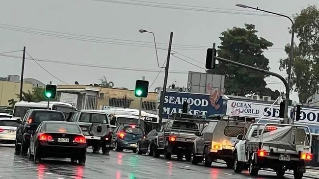
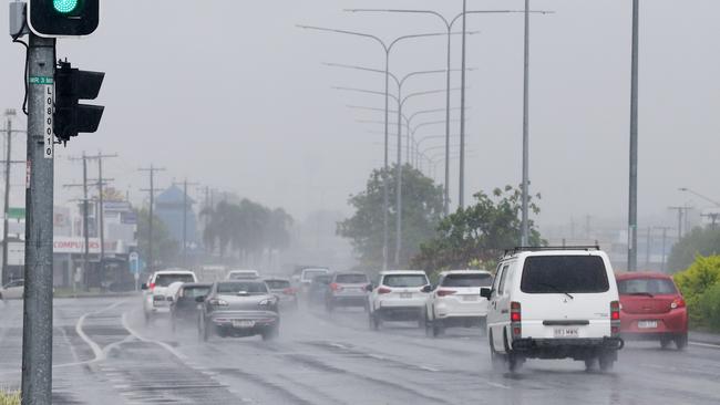
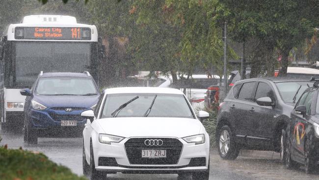
In Cairns, the totals have been higher towards the northern suburbs of the city, with reports of slow-moving traffic on the Captain Cook Hwy towards the CBD, on Friday morning.
Locations which may be affected by heavy rainfall included Cairns, Port Douglas, Ingham, Innisfail, Mossman, Cardwell, Yarrabah, Wujal Wujal, Gordonvale, Abergowrie, Julatten and Lucinda.
The next severe weather warning will be issued by 11am, Friday.
FAR NORTH RAINFALL TOTALS FROM 9AM, APRIL 21 TO 7AM APRIL 22
South Mission Beach Alert – 141mm
Bulgun Creek Alert (Tully) – 134mm
Cowley Beach – 126mm
Clyde Rd Alert (Babinda) – 79mm
Vohland Rd (Aloomba) – 71mm
Cairns Racecourse- 52mm
Cairns Airport – 55mm
Saddle Mountain – 68mm
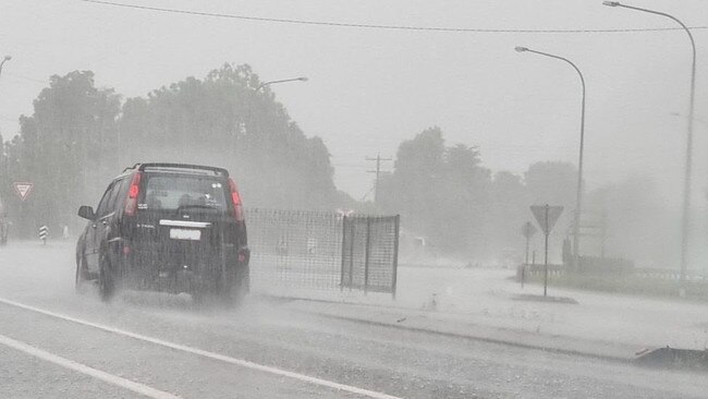
UPDATE THURSDAY 12PM: Up to 300mm of rain is expected to batter the region on Thursday and Friday and impact travel plans this long weekend, with forecasters warning drivers to stay off roads where possible.
Bureau of Meteorology forecaster Brooke Pagel said the region could expect localised intense rainfall, thunderstorms and flash flooding through to the end of the week, impacting areas between Daintree and Rollingstone.
“The trough causing (the rain) will deepen further and become slow moving on Friday before shifting north of Cairns on Saturday,” she said.
“Cairns is smack bang in the middle of where the trough is going to go.”
In the past 24 hours, 30mm of rain landed in Tully, with Innisfail receiving 20mm and 15mm at Daintree.
Ms Pagel warned of potential flash flooding across Cairns and the greater Far North region from Friday to Monday and recommended drivers stay off the roads where possible.
“We can expect 200mm-300mm today and Friday,” she said.
“We’re looking at 45mm-90mm on Saturday, 35mm-80mm on Sunday and 45mm-80mm on Monday,” she said.
The Cairns region should also expect king tide starting on Sunday and continuing through to Thursday next week.
Cairns Regional Council has cautioned residents not to walk, ride or drive through flood waters and to obey road signs.
King tide levels for Cairns
Sunday April 24 – 2.95m at 5:12am
Monday April 25 – 3:07m at 6:01am
Tuesday April 26 – 3.13m at 6:44am
Wednesday April 27 – 3.12m at 7:20am
Thursday April 28 – 3:03m at 7:52am
Friday’s weather
Cairns – 23C-27C Rain at times
Atherton – 19C-24C Rain at times
Cardwell – 21C-26C Rain at times
Cooktown – 23C-29C Rain at times
Innisfail – 21C-26C Rain at times
Mareeba – 22C-26C Rain at times
Mossman – 24C-27C Thunderstorm
Port Douglas – 24C-26C Rain at times
Rainfall in the past 24 hours
Cairns – 2.6mm
Atherton – 1mm
Cardwell – 4mm
Cooktown – 11mm
Innisfail – 20mm
Mareeba – 1mm
Mossman – 1mm
Port Douglas – 1mm
EARLIER: It is the wet season in one weekend as the clouds take shape over the Far North and the Bureau of Meteorology putting out severe weather warnings for Cairns and beyond.
BOM meteorologist Helen Kirkup said it’s a serious weather weekend for the region, with areas from Townsville to Cooktown receiving anywhere from 50mm to 150mm of rainfall in a 24-hour period.
“We’re looking at a deep trough moving very close to the coast and bringing rainfall with it,” she said.
“Depending where and how fast the trough moves, this predicted rainfall for Thursday could easily occur again on Friday.
“While it’s iffy to continue into the weekend, it isn’t out of the question.”
The BOM have prepared for the potential to put out flood watches as the rain batters the region, particularly on the Cassowary Coast.
“The Cassowary Coast is forecast to cop the most rainfall with 200mm to 300mm in a day,” Ms Kirkup said.
“It’s expected the coastal areas will cop the worst of it, but the Tablelands can expect 15mm to 30mm on Thursday and 25 to 60mm on Friday.”
Thursday’s weather
Cairns – 23C-29C Rain at times
Atherton – 19C-24C Rain at times
Cardwell – 22C-27C Rain at times
Cooktown – 23C-29C Showers
Innisfail – 22C-27C Rain at times
Mareeba – 21C-27C Showers
Mossman – 25C-29C Thunderstorm
Port Douglas – 23C-27C Thunderstorm
More Coverage


Originally published as Cairns weather: Heavy rainfall and flood warning as towns cop over 100mm

Is the Far North large enough for its own distribution centre?
Empty supermarket shelves across the Far North are sparking calls for the establishment of a local distribution centre, but not everyone is convinced it would make any difference.
Get used to my ‘big ideas’: Mayor
Mayor Amy Eden says those critical of her unexpected pitch to buy a stake in Cairns Airport need to get used to her “big ideas” while responding to early feedback.