Satellite pics catch China in the act in South China Sea
Commercial satellites have again caught China out in a move that that’s causing concern about its plans in the South China Sea.

Innovation
Don't miss out on the headlines from Innovation. Followed categories will be added to My News.
Commercial satellites have again caught China out: this time capturing photos of hidden anti-aircraft missiles installed on its “non-militarised” South China Sea islands.
Enormous engineering works began building islands out of the sandbanks and reefs of the South China Sea in 2015. At the same time, military facilities on the occupied Paracel Islands began to be dramatically upgraded.
Satellites have since watched over the construction of long runways, giant hangars, barracks – and gun emplacements – on what Beijing insists are merely search-and-rescue outposts.
Not everything was conducted in plain sight, however.
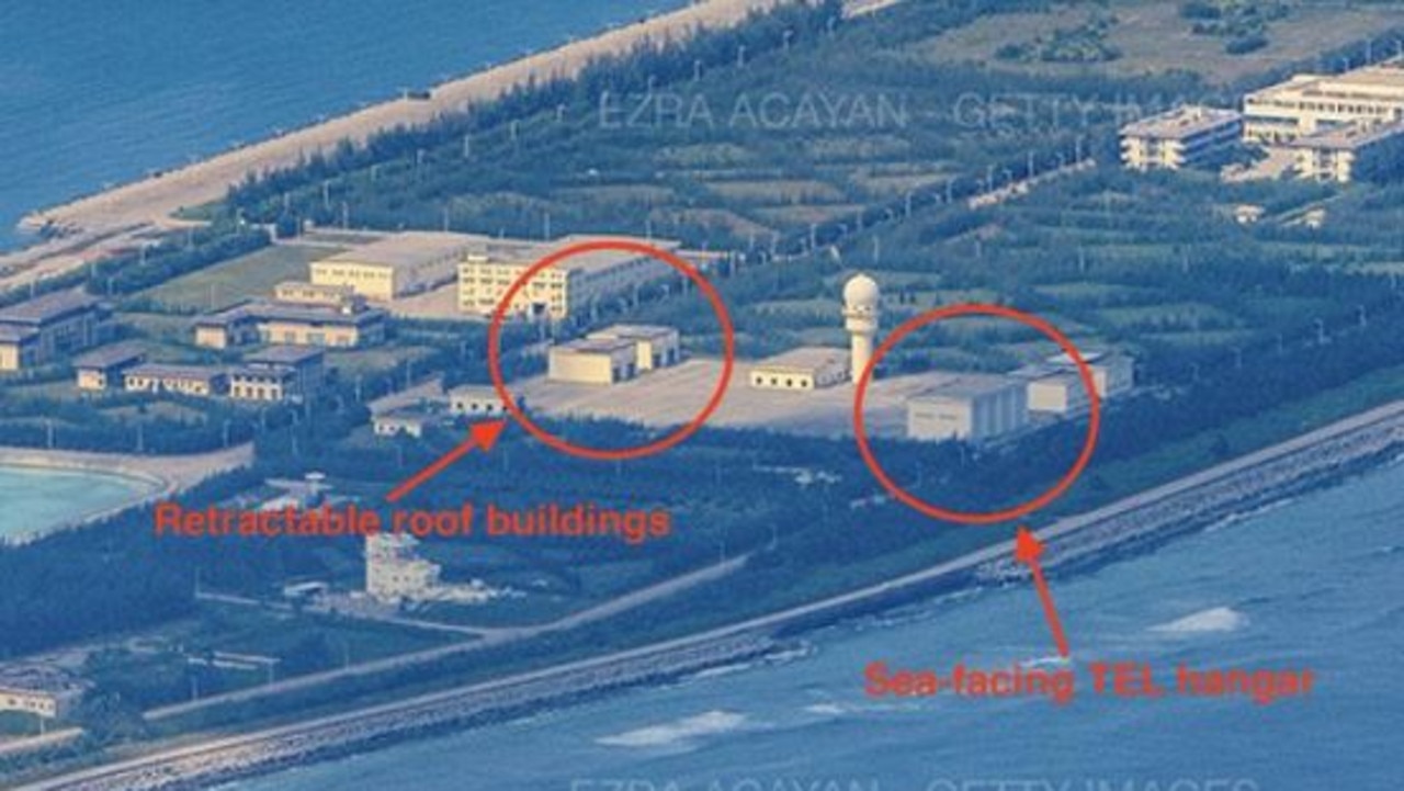
Reinforced pits may house ammunition dumps. But large sheds with ocean-facing roller doors and retractable roofs have remained a mystery.
Over on Mischief Reef, you can see another one these sea-facing tall-door buildings, as well as the retractable-roof buildings that are also on each island. pic.twitter.com/TZMy5vDB2D
— Tom Shugart (@tshugart3) October 27, 2022
Now analysts pouring over a steady stream of commercial satellite photos from the Spratly and Paracel Islands have caught China’s military at an inconvenient moment.
An April 26, 2022, Maxar Technologies photo of Woody Island in the Paracel group shows a row of four tall concrete buildings, each with two blue retractable roofs.
One set of roofs remained open.
And inside are what appear to be surface-to-air missile (SAM) launchers.
Air-control umbrella
The Paracel Islands were seized by China from Vietnam in 1974. Since then it’s gone on to occupy – and build – islands in the Spratlys, an area also claimed by Vietnam, the Philippines, Taiwan and Malaysia.
Since then, it’s been feared Beijing is preparing to impose its self-proclaimed sovereignty over 90 per cent of the South China Sea with an air and sea blockade.
But Chairman Xi Jinping insisted his artificial islands would not be militarised – despite the armoured aircraft hangars, guns and antimissile weapons prominently installed there.
...that is, until now.
— Tom Shugart (@tshugart3) January 24, 2023
In this image, we finally have a view of the buildings with the roof open & vehicles inside. While the resolution is a bit grainy, it looks to me like what we see is entirely consistent with an end-on view of the 4 vertical tubes of an HQ-9 SAM launcher. pic.twitter.com/gqzyRdSpIU
Since 2016, more and more military aircraft – primarily radar surveillance and anti-submarine patrol types – have been seen operating from their airfields.
Center for a New American Security (CNAS) analyst Tom Shugart says similar structures to those on Woody Island can also be found on Subi, Mischief and Fiery Cross reefs.
They are likely also built to conceal large anti-aircraft missile launchers.
China’s HQ-9 SAM system is believed to have a range of about 200km and can hit targets at high altitudes. It is possibly a derivative of Russia’s S-300 system, which has been used effectively by both sides in the war over Ukraine.
It’s not the first time the mobile launchers have been seen on Woody Island.
As early as 2016, an HQ-9 unit was spotted by the Imagesat Eros B satellite while deployed on a beach. But it is the first time they’ve been seen sheltering inside buildings.
Lines in the sand
“The situation in the South China Sea is far from stable. Chinese vessels engaged in dangerous and escalatory encounters with those of other states regularly throughout 2022. But for the first time in a decade, Beijing’s control over disputed waters did not appreciably advance,” says Asia Maritime Transparency Initiative (AMTI) analyst Gregory Poling.
Writing in the Asia Times, Poling says China’s coast guard and fishing militia had continued to harass Vietnamese, Philippines, Malaysian and Indonesian vessels at a similar rate to previous years. “But Southeast Asian governments, for the most part, held their ground.”
But over these years, AFAIK we've never seen any imagery or photos with the retractable-roof buildings open and showing them actually housing SAM launchers like these... pic.twitter.com/riUtBDHz9D
— Tom Shugart (@tshugart3) January 24, 2023
Incidents included the harassment of a Norwegian oil and gas survey ship and the prevention of supplies being delivered to Philippine troops at Second Thomas Shoal.
Poling says Vietnam has also undertaken land reclamation projects to expand its facilities in the South China Sea. But this amounts to just 420 acres against the 3200 acres created by China.
“Where are important legal and technical differences that make Hanoi’s work less escalatory. But the recent work is a noteworthy change,” he adds.
Much of the work has been around the harbours of Namyit and Pearson, suggesting Hanoi may be intending to deploy more forces to defend the islands and its nearby fishing fleets.
“Vietnam worries about the deteriorating balance of power in the South China Sea and welcomes pragmatic co-operation with the United States to address that imbalance. But it does not see an uncritical embrace of Washington as either beneficial or necessary,” Poling concludes.
Jamie Seidel is a freelance writer | @JamieSeidel
Originally published as Satellite pics catch China in the act in South China Sea


