
‘15C above average’: Warm weather and winds to continue as high fire danger warnings are put in place
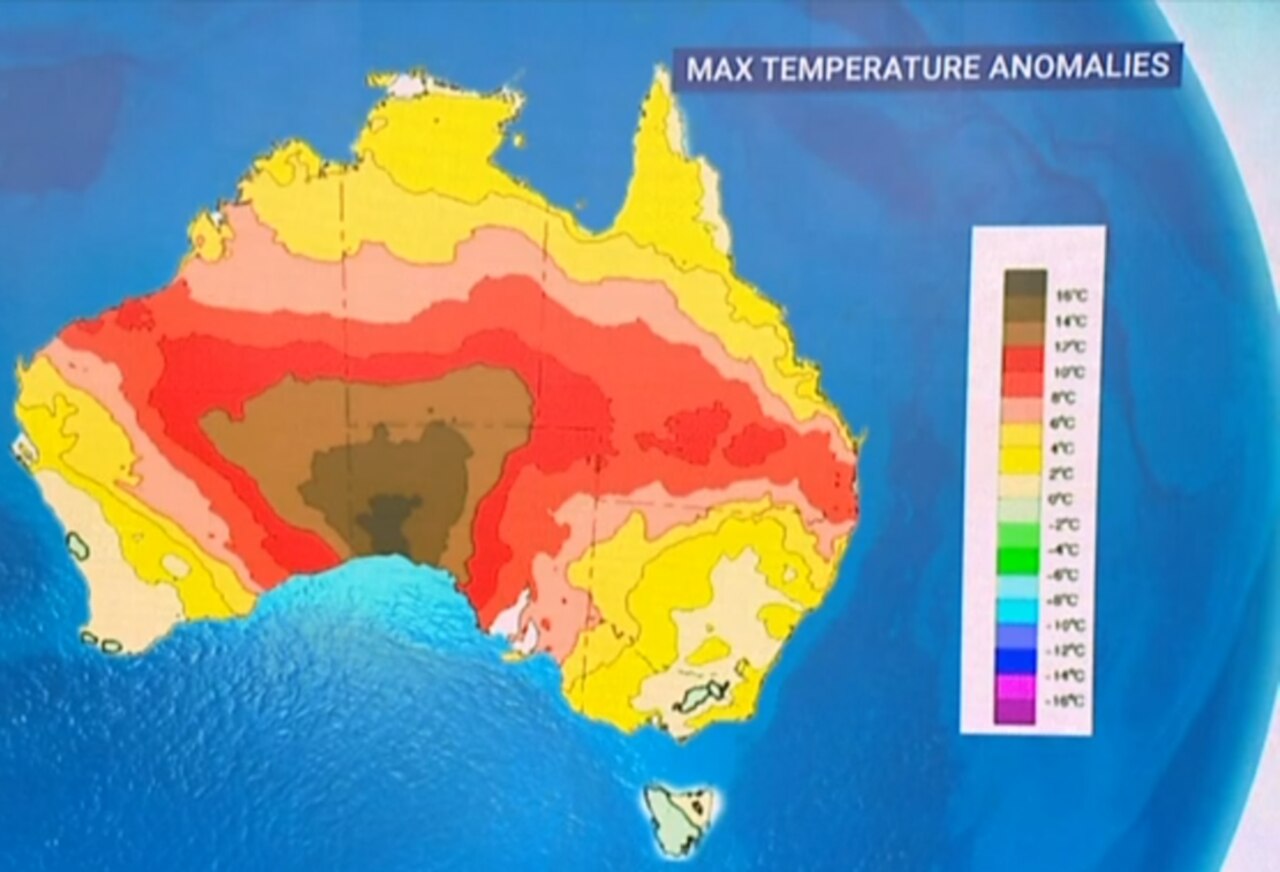
Temperatures are set to soar up to 15C above average across the country, with high fire danger warnings in place in several states, with warm weather and winds to continue into the weekend.
Environment
Don't miss out on the headlines from Environment. Followed categories will be added to My News.
Temperatures could soar up to 15C above average in coming days as high fire dangers are put in place across parts of the country.
Bureau of Meteorology senior meteorologist Miriam Bradbury said temperatures are expected to lift on Friday, with the country in for more sunny weather.
“We’ve got broadly dry and sunny weather, with heat being the main weather story, particularly through southern parts of the Northern Territory and southern Queensland,” Ms Bradbury said.
“Those temperatures may push up to 15C above average.”
The Greater Sydney region, Illawarra/Shoalhaven and South Western NSW have high fire danger ratings in place for Friday, while much of the state has moderate warnings in place as winds are expected to continue.
Channel Country, Maranoa and Warrego in Queensland also have high fire danger ratings in place, as well as Darwin and Adelaide River in the Northern Territory.
High fire danger warnings will be in place for Ashburton Coast Exmouth Gulf Coast, South Goldfields, South Interior, Eucla, Fitzgerald Coast, Fitzgerald Inland, Esperance Coast and Esperance Inland in Western Australia.
Queensland can expect a foggy start along the east coast, but will have dry and mostly sunny conditions across the state, with fire dangers for the Southern inland as “gusty winds start to develop”.
“We’ve got temperatures really increasing up to the high 30s across the West Brisbane, heading for a top of 32 degrees, which is almost 10 degrees above average,” Ms Bradbury said.
NSW will have a windy start to the day, particularly in the Central and Southeast ranges, the Illawarra, and parts of the South Coast, with a few showers possible.
“Both the showers and the winds should start to ease back later in the day, fairly warm through the north and east Sydney, heading for a top of 29 degrees,” Ms Bradbury said.
“Although with those stronger winds, it may feel slightly milder.”
Canberra will be 20C and partly cloudy, while Victoria will be wet and windy, with Melbourne reaching a top of 19C with showers.
Tasmania is also set to be wet and windy, with concerns over flooding as showers are expected to remain “persistent” in the west of the state.
Hobart is expected to reach 14C, while Adelaide will reach a top of 18C as strong winds and rain are set for the lower southeast coast.
Perth is tipped to reach a high of 19C with warm weather up north, though showers on the southwest coast could impact Perth.
Darwin is expected to reach a top of 33C.
BRUTAL WINDS CONTINUE
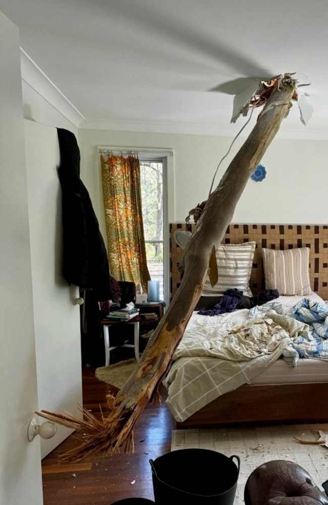
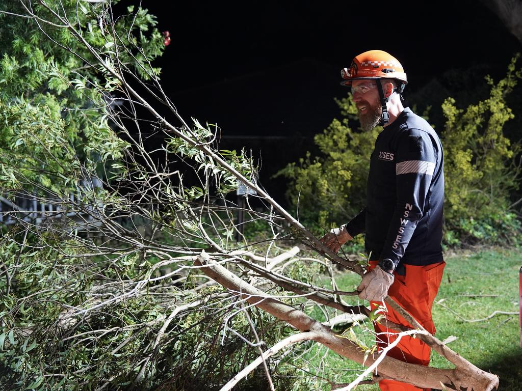
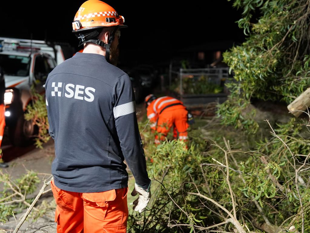
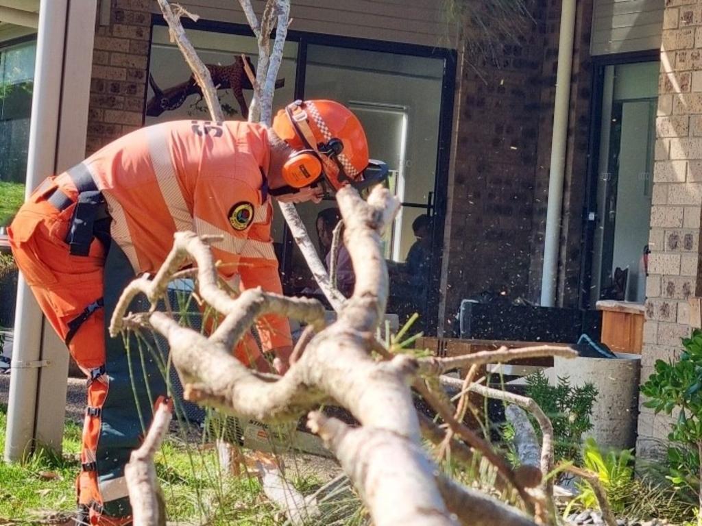
State Emergency Service crews in New South Wales were left flat out overnight Wednesday and into Thursday morning, being called to nearly 1300 incidents as brutal winds sweep large parts of the country.
Figures released early Thursday morning by the NSW SES show the service was required at 1286 incidents on Wednesday, mostly in the state’s southeast.
Hundreds of calls for help were also made from within the wider Sydney metro area.
The volunteer group will continue to clean up 300 incidents on Thursday, a spokesperson said.
Severe Weather Update: Damaging wind continues across the south-east on Wednesday, then Western Australia on Thursday.
— Bureau of Meteorology, Australia (@BOM_au) August 28, 2024
Video current: 12pm AEST Wednesday 28 August 2024
Know your weather. Know your risk. Latest: https://t.co/4W35o8iFmh or the BOM Weather app. pic.twitter.com/SonyRaZA2Z
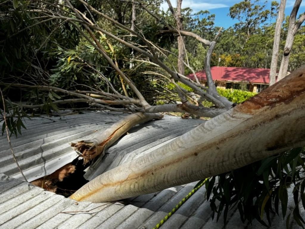
Roads in many areas of the state were cut off by fallen trees, powerlines, and dislodged parts of buildings.
The Illawarra region copped the brunt of the chaos, as roof tiles and windows were ripped from their foundations onto main thoroughfares.
Parts of a patrol station roof were blown off in Gwynneville. A window frame from the Spotlight building in Wollongong blew off and hit a pedestrian. A large gazebo landed on a vehicle at Bowral.
The Bureau of Meteorology has reissued severe weather warnings, as damaging winds are expected to redevelop in eastern and south eastern parts of NSW from Thursday night into Friday.
Winds averaging 60 to 70km/h with 90km/h gusts are possible from late Thursday evening for the Snowy Mountains. For areas above 1900 metres, damaging winds may average 80 to 90km/h with peak gusts about 125km/h.
Winds are expected to ease during Friday afternoon.
Friday morning the Illawarra and Tablelands can expect 60km/h winds with 100km/h gusts, particularly at Wollongong, Nowra, Bowral, Batemans Bay, Katoomba and Goulburn.
People should move cars to cover or away from trees, secure or put away loose items outside the house, keep away from fallen powerlines and beware that trees which may have been burnt at some stage are likely unstable.
Victorian emergency services have issued flood warnings immediately across the border due to storm surges.
The wider Gippsland region can expect abnormally high tides from Friday night and through the weekend.
Further sea water flooding with the evening high tides, particularly around low-lying coasts of the Gippsland Lakes, should be expected.
A similar threat warning issued in the past 36 hours has abated for now.
Damaging surf conditions along the South West Gippsland and exposed Central coasts have calmed on Thursday morning, but will redevelop from the early hours of Saturday and then persist until Monday.
People should stay well away from the surf and surf exposed area because of the threat of beach erosion.
In particular, exposed west and south-facing coasts between Nelson and Cape Otway and between St Andrews Beach and Wilsons Promontory are most at risk of damaging surf conditions, VicEmergency says.
Locations which may be affected by abnormally high tides include Lakes Entrance, Metung, Paynesville. Locations which may be affected by damaging surf include Warrnambool, Portland, Nelson, and southern parts of Mornington Peninsula and Phillip Island.
On Wednesday two firefighters were injured as 80 firefighters fought to save homes in Sydney’s south west, about 2pm at Horningsea Park.
About the same time in Victoria’s southwest, a man died and a woman was critically injured when a tree fell on their car.
The incident happened at Gellibrand about 1.30pm. The injured woman was flown to hospital.
Originally published as ‘15C above average’: Warm weather and winds to continue as high fire danger warnings are put in place

States told to brace for weekend cold front
Windy weather has finally subsided across Australia’s southern regions, but a cold front is bearing down on these states for the weekend.

Fury as fire ants hit major coalmine
A fire ant outbreak has hit a coalmine in a major mining state, with environmentalists calling the discovery a “spectacular failure”.

‘Year-round’: New Sydney shark warning
An aggressive shark species could be staying for longer in the world-famous Sydney Harbour, new research has warned.

Wild weather warning for this capital city
There will be “one last sting in the tail” of the polar air blast that has marched across Australia, with wild winds to continue battering the nation.

‘Won’t survive’: Huge fear for Aussie treasure
Politicians have been served a major wake-up call when it comes to the management of one of the world’s most-treasured natural wonders.

Antarctica disappears before our eyes
Our precious polar continent is losing a devastating amount of its sea ice, threatening our planet’s climate more every day.