
Cyclone Gabrielle starts to batter New Zealand, sparking severe weather warnings
Severe weather warnings are in place across much of New Zealand as the country begins to endure the severe wrath of Cyclone Gabrielle.
Environment
Don't miss out on the headlines from Environment. Followed categories will be added to My News.
Thousands of homes in New Zealand’s largest city were without power on Sunday night and residents were being urged to stay indoors as Cyclone Gabrielle started to batter the nation’s North Island.
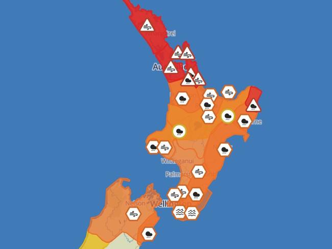
Severe weather warnings remain in place across the entire north coast of the island, with extreme rain and high winds expected to continue into Tuesday. They include red warnings for heavy rain and severe gales in Northland, Auckland and the Coromandel Peninsula.
“Based on the position and intensity of Gabrielle, this system poses a very high risk of extreme, impactful and unprecedented weather over many regions of the North Island from Sunday to Tuesday,” MetService, New Zealand’s equivalent of our Bureau of Meteorology, said in an official assessment.
“Gabrielle is expected to move close to the upper North Island during Monday and Tuesday. Impacts are already being felt across northern parts of the island, and are expected to spread south across the rest of the island, through to northern parts of the South Island.
“This will be a widespread and significant weather event. Significant heavy rain and damaging winds are forecast for many parts of northern and central New Zealand. Large waves, storm surges and coastal inundation are expected.”
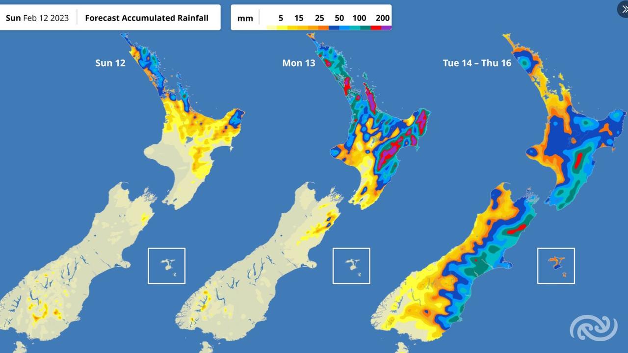
About 100mm of rain’s already fallen in the Northland Peninsula, with a further 150-250mm forecast, along with wind gusts of 120-130 kilometres per hour.
“This rain is expected to cause dangerous river conditions and significant flooding. Slips and floodwaters are likely to disrupt travel, making some roads impassable and possibly isolating some communities,” MetService warned.
A similar amount of rain will fall in Auckland, most of it on Monday.
The city has released a list of almost 30 emergency shelter locations, with residents instructed to stay home unless they have an “absolutely urgent need” to travel. Train services have been suspended until at least 3pm on Monday, and many schools are staying shut, though the government is leaving that decision to them for now.
“Boards and principals are in the best position to decide when it is safe for on-site teaching and learning,” Education Secretary Iona Holsted said on Sunday.
“This is a fast-moving and emerging situation, and the purpose of (these instructions) is to support schools to confidently make decisions in light of the presenting risks. The ministry will keep monitoring the latest information and will respond accordingly.”
More than 15,000 homes are believed to be without power in Auckland, with a further 8000 without power outside the city.
“If you are currently without power, it is very likely you will be without power overnight and possibly for several days,” electricity company Northpower said.
“We expect the weather situation to worsen over the next day or so, which will inevitably result in more outages. Until this wind abates, it is not safe to begin repairs.
“Please be assured we will be doing all we can to restore power as quickly as we can when we can.”
As The New Zealand Herald has reported, Gabrielle has multiple atypical features that could make its impact particularly severe.
On Tuesday morning, it may break New Zealand records for atmospheric pressure at mean sea-level (MSLP).
“The tighter the pressure-packing, the stronger the winds (and) more intense the weather,” Ben Noll, a meteorologist from the National Institute of Water and Atmospheric Research, told The Herald.
“With Gabrielle, it’s looking quite likely that it’s going to deepen or intensify just as it tracks immediately east of Northland and Auckland, or maybe around the top of the Coromandel.
“That deepening and slowing right around northern New Zealand is what’s causing concern for forecasters in terms of the amplification of those intense rain and wind impacts.”
During the almost two centuries in which records have been kept, New Zealand has previously experienced pressure levels of about 970 hectoPascals (hPa), with the “weather bomb” of 2008 and Cyclone Giselle in 1968 even reaching the low 960s.
Gabrielle is currently predicted to cause pressure levels to dive to about 961 hPA.
In addition, meteorologists believe the storm is developing a “sting jet”, a narrow zone of powerful wind that originates within the mid-tropospheric cloud head.
Overnight, #CycloneGabrielle moved over Norfolk Island with pressure bottoming at 958.0 hPa. Water vapour imagery this morning displaying that Gabrielle is starting to develop a scorpion tail 'sting jet' signature as it transitions to becoming a strong extratropical cyclone. pic.twitter.com/L3XDXdLTUR
— Hauraki Gulf Weather (@GulfHauraki) February 11, 2023
Auckland previously endured a sting jet phenomenon in April of 2018, in a storm that exposed how unprepared much of the city was for extreme weather events.
That storm caused flooding, brought damaging winds to bear, knocked out power for thousands of homes, and reportedly left a staggering three-quarters of Auckland’s businesses unable to function.
– with The New Zealand Herald
Originally published as Cyclone Gabrielle starts to batter New Zealand, sparking severe weather warnings

States told to brace for weekend cold front
Windy weather has finally subsided across Australia’s southern regions, but a cold front is bearing down on these states for the weekend.
Read more

Fury as fire ants hit major coalmine
A fire ant outbreak has hit a coalmine in a major mining state, with environmentalists calling the discovery a “spectacular failure”.
Read more

‘Year-round’: New Sydney shark warning
An aggressive shark species could be staying for longer in the world-famous Sydney Harbour, new research has warned.
Read more

Wild weather warning for this capital city
There will be “one last sting in the tail” of the polar air blast that has marched across Australia, with wild winds to continue battering the nation.
Read more

‘Won’t survive’: Huge fear for Aussie treasure
Politicians have been served a major wake-up call when it comes to the management of one of the world’s most-treasured natural wonders.
Read more

Antarctica disappears before our eyes
Our precious polar continent is losing a devastating amount of its sea ice, threatening our planet’s climate more every day.
Read more