
Giant hail, flash flooding to hit Victoria, risk of tornadoes
The SES has received more than 100 calls for help after severe thunderstorms ripped through the state.
News
Don't miss out on the headlines from News. Followed categories will be added to My News.
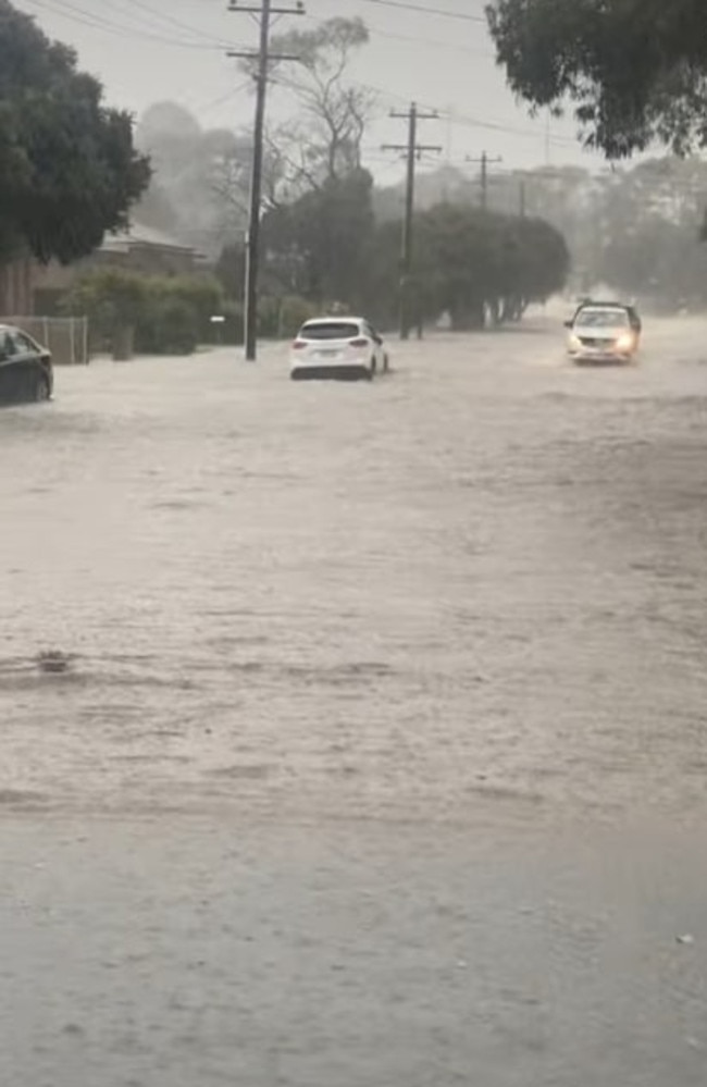
Predicted thunderstorms for the state have arrived and they weren’t mucking around with Geelong copping an absolute lashing and receiving more than 50mm of rain in an hour.
Frankston on the opposite side of Melbourne was also heavily hit, copping 40mm in roughly half an hour, while the city itself recorded 29mm across the day, which is close to half the monthly average rainfall for October.
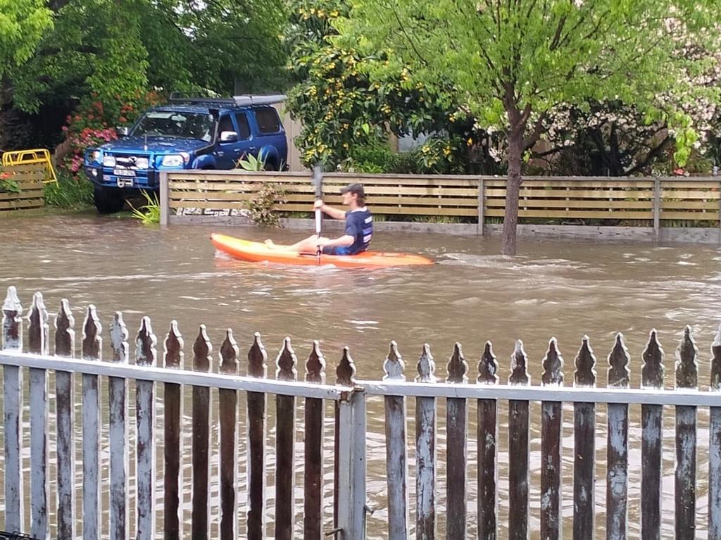
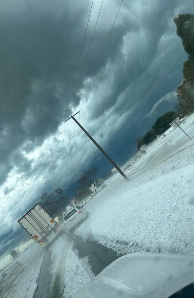
But Geelong was easily the hardest hit with pictures and videos posted online showing people kayaking down streets and cars traversing rushing tyre high water, after a “life threatening flash flooding” warning was announced.
Sirens could also be heard blaring across Melbourne Airport as lightning came within 9km of the airfield sending workers ducking for cover.
A spokesperson from the SES confirmed it had been a busy afternoon for crews with Geelong and Frankston both receiving 51 call-outs, Aintree in Melbourne’s north receiving 26 and Craigieburn 23.
Nearly all the calls related to damaged property or flooding.
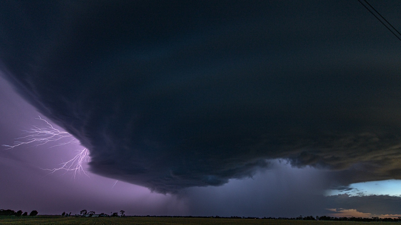
Victorians were bracing for severe thunderstorms on Friday, with authorities warning of the possibility of tornadoes, flash flooding, destructive winds and giant hail.
Senior meteorologist Miriam Bradbury said there was a slight possibility that tornadoes could form in the state’s northeast as part of the “very dangerous” thunderstorm forecasted to hit the area.
And Melbourne is set to get a spring soaking, with up to 30mm of rain to fall.
“We might not just see damaging, but destructive winds over 125km/h and giant sized hail bigger than 5cm and intense rainfall,” Ms Bradbury said.
“In addition, there is a slight chance through the northeast of tornadoes, but the risk is more on the New South Wales side of the border.”
âš ï¸ A VERY DANGEROUS THUNDERSTORM with intense rainfall that may lead to LIFE THREATENING FLASH FLOODING is approaching #Geelong. SEVERE THUNDERSTORM WARNING is current with multiple storms across the #Melbourne area.
— Bureau of Meteorology, Victoria (@BOM_Vic) October 18, 2024
Full details: https://t.co/FNQhCbStWfpic.twitter.com/8CnRUqUcuH
Ms Bradbury said severe storms are possible across the entire state including the Melbourne area.
“A strong cold front and low pressure system is moving across the whole of south east Australia (on Friday). Warm humid air ahead of the system provides suitable conditions for storms to develop,” she said.
“In Melbourne we’re not really expecting destructive winds and giant hail, but we’re keeping an eye on the radars to see if severe storms develop, particularly in the early afternoon on Friday.
“Any storm will produce a lot of rain and gusty winds that can bring down trees and powerlines.”
Flash flooding likely folks. Don’t forget your â˜‚ï¸ #Melbourne#melbweather#melbourneweatherpic.twitter.com/LygfBr5w5E
— Victorian Storm Chasers (@VicStormChasers) October 17, 2024
She said Melbourne is expected to see up to 30mm in rain on Friday, with the risk of flash flooding on roads.
“We’re not expecting riverine flooding at this stage, but our flood teams are keeping a close eye on it,” she said.
Severe Weather Warning for damaging winds
— VICSES News (@vicsesnews) October 17, 2024
Stay informed: https://t.co/U2WKNw7RUw
For people in parts of Central, East Gippsland, North Central, North East and West and South Gippsland Forecast Districts. pic.twitter.com/UFWqEaDwaK
The Bureau issued a severe thunderstorm warning for heavy rainfall and damaging winds for residents in Victoria’s Central, South West, North Central, Wimmera, Mallee and Northern Country regions, about 10.30am on Friday morning.
Wooloomanata station, in Little River near Geelong, recorded 22mm between 9am and 10am.
Areas most likely to be affected include Lara, Werribee, Point Cook, Portarlington, Horsham, Stawell, Hamilton, Ballarat, Geelong and Bacchus Marsh.
The Bureau also issued a severe weather warning for residents in parts of Central, East Gippsland, North Central, North East and West and South Gippsland Victoria for damaging winds.
Strong winds averaging 50 to 60 km/h with damaging wind gusts of about 90 km/h are expected about the central and northeastern ranges, with the risk extending to the outer northern suburbs of Melbourne about midday on Friday.
Locations which may be affected include Bacchus Marsh, Mt Baw Baw, Falls Creek, Mt Hotham, Mt Buller and Omeo.

Heavy rain delayed the start of opening practice of the Australian MotoGP at Phillip Island.
The rain band that is sweeping across Victoria hit the track about 10.15am, forcing spectators to run for shelter or take cover under umbrellas.
Race authorities ordered a delay to the start of the MotoGP practice session which was scheduled to start at 10.45am.
The earlier opening sessions for Moto2 and Moto3 categories were completed with a few riders sliding off in the slippery conditions.
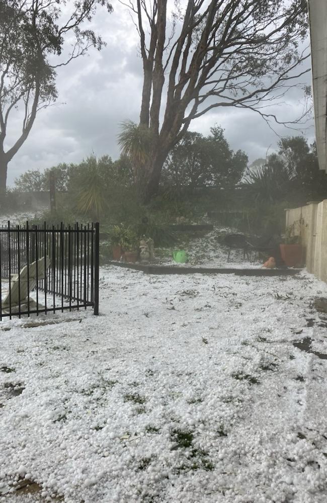
It comes after torrential rain, hail and high winds hit Victoria’s southwest, causing sky lights to smash, roofs to collapse and water to gush in through light fixtures earlier this week.
The small town of Casterton experienced the brunt of the storm on Wednesday night, with 22mm of rain falling in 10 minutes and hail the size of golf balls falling on properties.
Melburnians can expect more settled conditions on Saturday and Sunday as the cold front shifts off the east coast and moves away from Victoria.
“It could still be showery, particularly through Gippsland, but it looks like it will ease,” she said.
“Sunday will see mostly dry conditions with a bit more sunshine.”
Melbourne is forecasted to reach 24C on Friday, and 18C on Saturday and Sunday.
The State Emergency Service advised Victorians to stay indoors and avoid travel if possible, secure loose items such as outdoor settings and trampolines, and move vehicles under cover or away from trees.
Residents are urged to monitor weather warnings, forecasts and river levels at the Bureau of Meteorology website, and warnings through VicEmergency website, app and hotline.

Originally published as Giant hail, flash flooding to hit Victoria, risk of tornadoes

Taxpayers lumped with huge bill for anti-Israel vandalism
The cleaning bill for Pro-Palestine vandalism on Labor MPs’ offices has been revealed, with a Victorian Jewish MP copping most of the damage.

High country campers’ loved ones want ‘the truth’ from Greg Lynn
As Greg Lynn was sentenced to 32 years in jail for the murder of Carol Clay, the family of Russell Hill says he should come clean on what really happened to the campers, while the parents of his late former wife say they’re still “looking for justice”.

Hells Angels and leather bikinis: Why Suzi Quatro loves Melbourne
Ahead of her upcoming Rockin’ On tour in Australia, rockstar Suzi Quatro explains why she’ll never use the F-word again.

‘Love you forever’: Heartbreak as three-year-old dies after Endeavour Hills collision
The distraught mother of a three-year-old girl who died in hospital after being hit by a car in Endeavour Hills has told of her devastation, saying she was “such a good girl”.

Melbourne home hammer time reaching boiling point
Victoria has reached the peak of its spring market with more people set to make a purchase or sale in the next eight days than any other time of the year. See the homes we’re watching.
Pro-Palestine reference in mock exam paper shocks Jewish students
Victorian Jewish students have revealed their distress over a practice legal studies exam paper from a private company containing a pro-Palestinian article.