
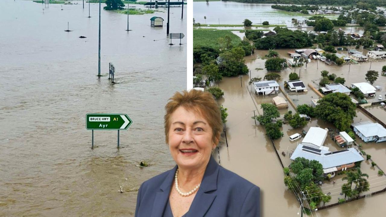
Burdekin region receives respite from flooding, but rainfall threat lingers
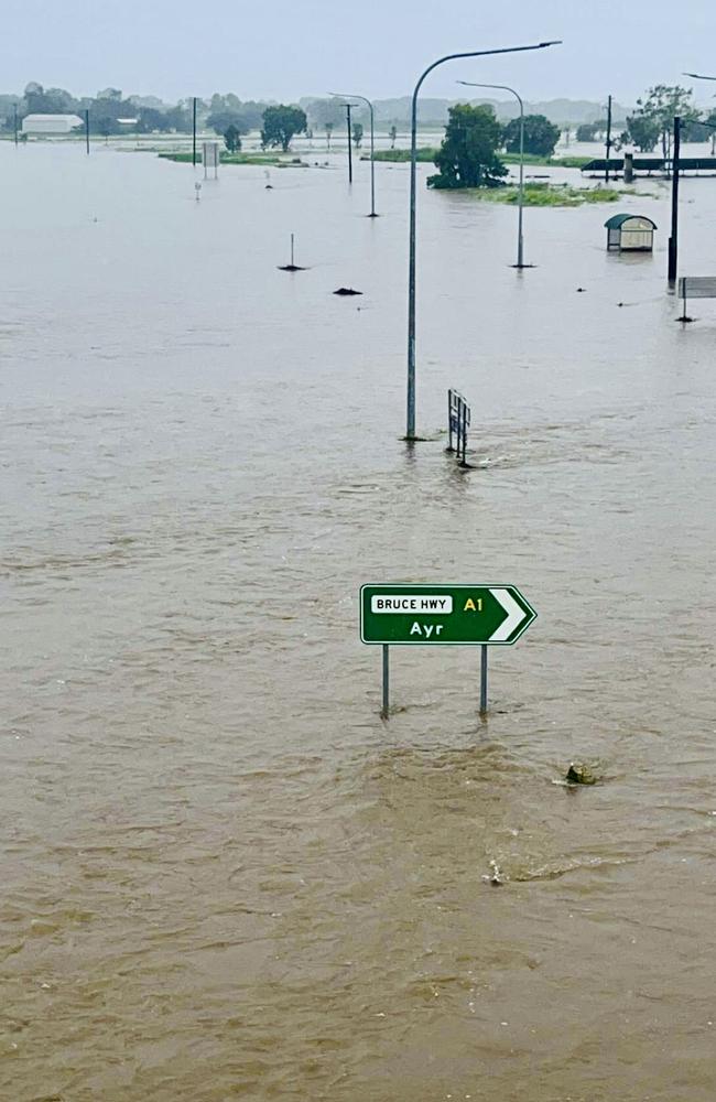
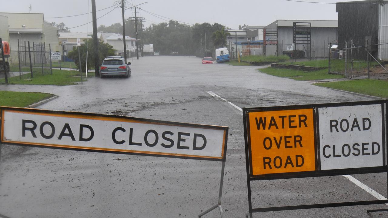
The Bruce Highway has reopened after rainfall totals dropped for the Burdekin region, but other streets remain underwater and some residents remain cut off. Read the latest update.

Townsville
Don't miss out on the headlines from Townsville. Followed categories will be added to My News.
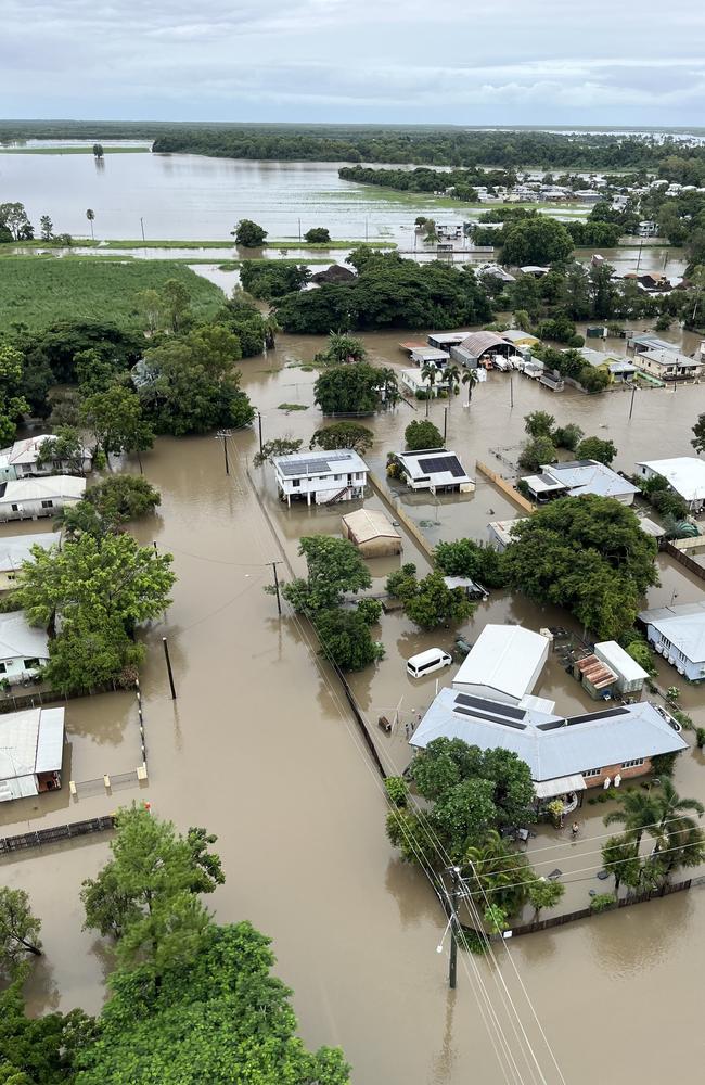
Triple figure rainfall totals dropped back to double digits overnight Wednesday, giving respite to residents in the Burdekin region, but numerous streets are closed, major flood warnings remain in place, and more rain is on the way.
Burdekin Shire Mayor Pierina Dalle Cort said on Tuesday that things were “looking pretty good” at this stage in the Burdekin and this were moving well at flood-impacted Giru, with power restored and water trucks topping up their supply.
She said the Bruce Highway had been reopened between Ayr and Townsville at around 9am this morning, allowing supplies to restock Giru, along with the Burdekin’s two supermarkets.
The Giru township remains under essential water use restrictions until supply levels can be replenished, a process that could still take some time, with residents advised to only use water for essential needs.
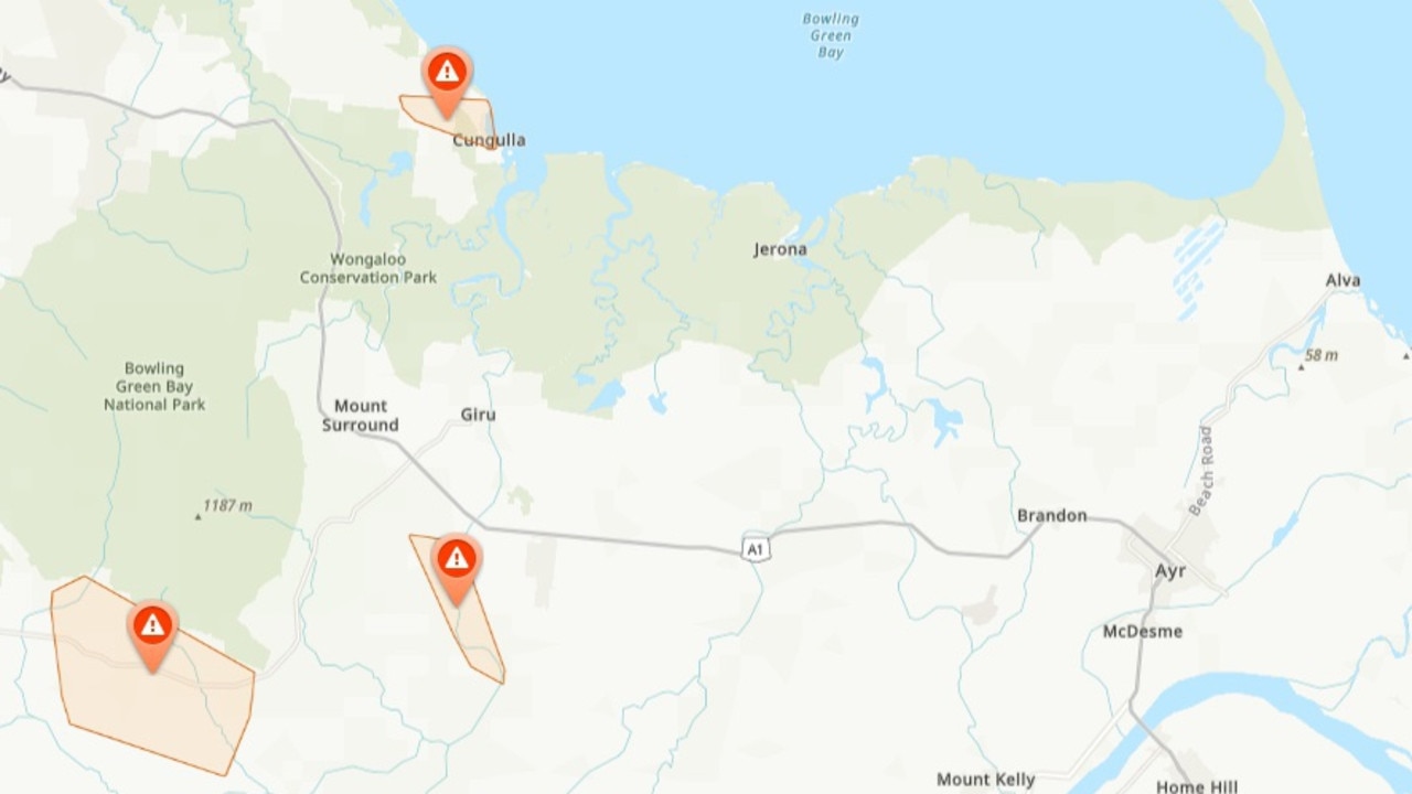
Up to 40 households remained cut off in the Jerona area, next to Barratta Creek, on the coast between Giru and Brandon, as well as residents living along Woodstock Giru Rd and on Rita Island.

“They’ve been isolated for some time now, five days … they’re usually well prepared,” Ms Dalle Cort said.
“But obviously we’ll be looking at probably resupplying them somehow, some way, as soon as we can, when the need arises. But otherwise, things are looking positive at the moment.”
Ergon Energy said on social media that it had crews on the ground around Giru and they were troubleshooting in the Cungulla area where they could see wires down, but haven’t had access so far.
“We’re seeing some rays of hope on the Burdekin River’s Macrossan Bridge which is still underwater, but now visible: when it reopens, we’ll have access to Charters Towers again. And levels seem to have peaked around the Burdekin (fingers crossed),” Ergon said.
Burdekin weather warnings
In its Tuesday morning update, the Bureau of Meteorology has reduced its flood warning for the Upper Burdekin River and Lower Burdekin River down to a moderate level.
As of Tuesday morning, the overflowing Burdekin Falls dam was at 4.73m and rising, sitting at 178.95 per cent capacity, and could reach the moderate flood level (5.5m) on Tuesday afternoon into the evening.
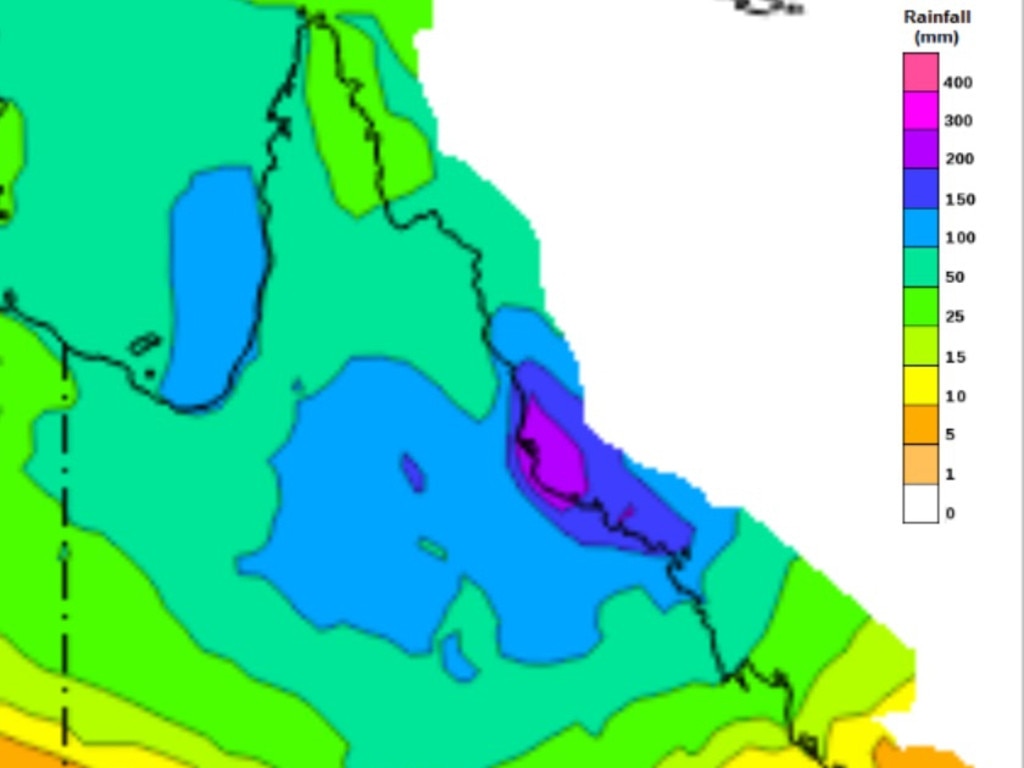
“Significant rainfall totals have been recorded in the upper Burdekin catchment on the eastern ranges around Paluma and surrounds. These totals have resulted in river level rises along the upper Burdekin River to Burdekin Falls Dam,” the BOM said.
“Further rainfall is forecast over the next few days. This situation is being closely monitored, and warnings will be updated as necessary.”
Moderate flooding was occurring along the Burdekin River to the Burdekin Falls Dam, peaking at Selheim at 19.27m around 4pm on Monday, and was at 13.55m and falling at 10.52am on Tuesday.
It was likely to remain above the major flood level (15m) pm Tuesday afternoon.
Downstream of the Burdekin Falls Dam, moderate flooding was likely.
The Burdekin River at Dalbeg is currently at 13.53 metres and rising, with minor flooding, likely likely to reach the moderate flood level of 15m Tuesday afternoon into the evening.
The Burdekin River at Clare was currently at 10.4m and rising, with minor flooding, likely to reach the moderate flood level of 13m overnight Tuesday into Wednesday.
The Burdekin River at Inkerman Bridge sits at 7.73ms and rising, with minor flooding, likely to reach the moderate flood level of 10m on Wednesday morning.
Further rises to these levels were possible with the arrival of upstream flow, and forecast rainfall.
A moderate flood warning also remains for the Haughton River catchment, with moderate flooding continuing to ease at Giru and along Major Creek on Tuesday afternoon.
“Significant rainfall totals in excess of 900mm have been recorded across the Haughton River catchment since Monday last week. Rain and showers are forecast to continue over the next few days, but are easing,” the BOM said.
“River levels upstream of Giru have peaked and are now falling slowly. Moderate flooding continues along the Haughton River at Giru, but is easing.
“The Haughton River at Giru is currently at 2.38m and falling, with moderate flooding. The Haughton River at Giru is likely to fall below the moderate flood level (2.10m) Tuesday evening.
“The river level may fall below the minor flood level (1.8m) overnight Tuesday into Wednesday. Renewed rises are possible with forecast rainfall.”
Transfer station and waste update for the Burdekin
Burdekin Shire Council’s kerbside collection trucks will be back in operation on Tuesday.
Due to access issues, green waste and recycling collections cannot take place.
Please keep your bins out in case collection becomes possible for green waste and recycling waste.
If your bin was not emptied on Friday or Monday or your property is unable to be serviced due to road closures it will be scheduled for collection after Tuesday’s regular run.
Councils’ waste contractors will endeavour to catch up each day after normal scheduled collections to avoid confusion.
• Home Hill Transfer Station is open. Surface water over road in some routes to the Transfer Station so please proceed with caution.
• Ayr Transfer Station remains open.
• Kirknie Landfill remains closed to the public.
Disaster assistance is now available for residents in the Burdekin
If you’ve been affected by recent flooding, a range of financial support options are available to help.
Eligible residents can access emergency payments of $180 for individuals and up to $900 for a family of five or more to cover essential costs like food, clothing, and medicine.
Impacted residents can check their eligibility and apply for assistance via www.qld.gov.au/disasterhelp or by calling the Queensland Community Recovery Hotline on 1800 173 349.
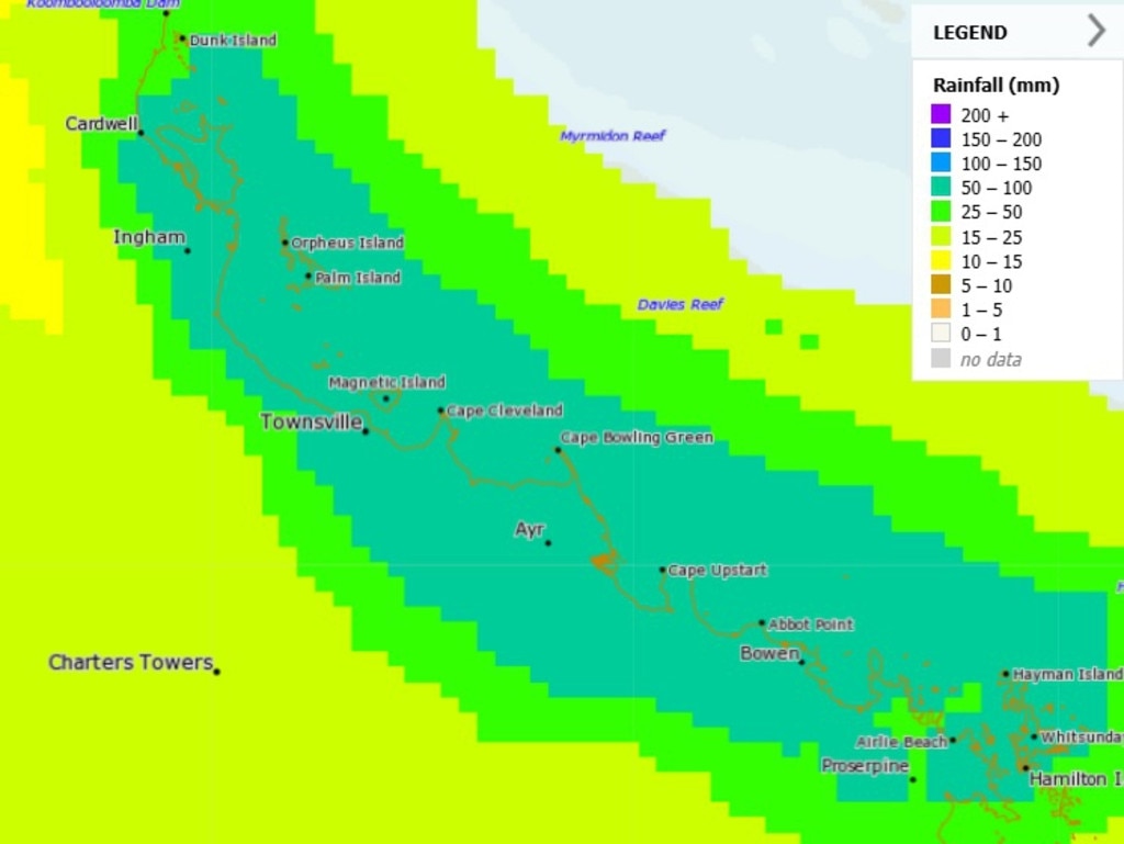
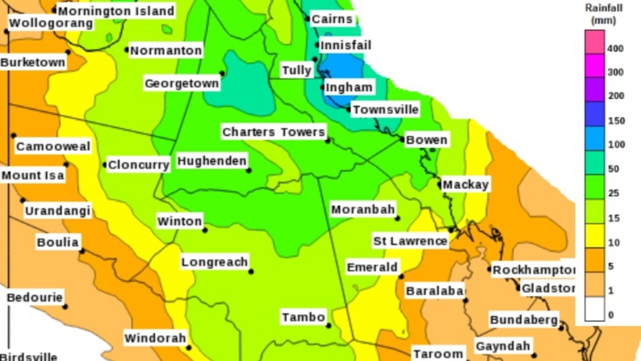
Rainfall totals for the Burdekin area over the past week
• Ayr 20mm until 9am Tuesday. Previously 256mm on Monday, 196mm Sunday, 206mm Saturday, 83mm Friday, 61mm Thursday, 113mm Wednesday, 155mm Tuesday. Total
Over a metre of rain has fallen in Ayr over the past week. 1090mm.
• Giru 24mm until 9am Tuesday. Previously 77mm on Monday, 209mm Sunday, 216mm Saturday, 20mm Friday, 32mm Thursday, 65mm Wednesday, 77mm Tuesday. Total 720mm
Burdekin weather forecast for the coming days
Wednesday: Min 23 Max 28. Cloudy. Very high chance of rain. The chance of a thunderstorm. Heavy falls possible. Possible rainfall: 30 to 80mm. Chance of any rain: 95 per cent.
Thursday: Min 23 Max 28. Rain. Cloudy. Very high chance of rain. The chance of a thunderstorm. Possible rainfall: 7 to 45mm. Chance of any rain: 90 per cent.
Friday: Min 23 Max 28. Cloudy. Very high chance of showers. The chance of a thunderstorm. Heavy falls possible inland. Possible rainfall: 3 to 40mm. Chance of any rain: 90 per cent.
Saturday: Min 23 Max 28. Showers. Possible rainfall: 0 to 35mm. Chance of any rain: 80 per cent.
Sunday: Min 23 Max 30. Shower or two. Possible rainfall: 0 to 15mm. Chance of any rain: 70 per cent.
Monday: Min 22 Max 31. Shower or two. Possible rainfall: 0 to 5mm. Chance of any rain: 50 per cent.
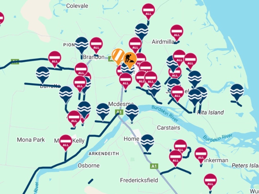
Burdekin region road closures
• Jarvisfield Butler Rd Flooding Lanes affected – All lanes affected
• Home Hill Burdekin Rd – Milburn Rd Flooding Lanes affected – All lanes affected
• Cromarty Cromarty Siding Rd – Reed Beds Rd Flooding Closures – Road closed to all traffic
• Inkerman Coppo Rd Flooding Closures – Road closed to all traffic
• Inkerman Wallace Rd Flooding Closures – Road closed to all traffic
• Mount Kelly, Airville Menso Rd, Menso Rd Flooding Lanes affected – All lanes affected
• Brandon Kidd Rd Flooding Lanes affected – All lanes affected
• Brandon Five Ways Rd Flooding Closures – Road closed to all traffic
• Inkerman Bojack Rd Flooding Lanes affected – All lanes affected
• Airville Leibrecht Rd Flooding Lanes affected – All lanes affected
• Upper Haughton Brown Rd Flooding Lanes affected – All lanes affected
• Airville Kelly Rd Flooding Closures – Road closed to all traffic
• Rita Island Switchback Rd Flooding Lanes affected – All lanes affected
• Jarvisfield Towers Rd Flooding Lanes affected – All lanes affected
• Ayr Patricia Rd Flooding Closures – Road closed to all traffic
• Airville Barrett Rd Flooding Closures – Road closed to all traffic
• Airville Airville Rd Hazard Closures – Road closed to all traffic
• Airdmillan Old Wharf Rd Hazard Closures – Road closed to all traffic
• Brown Rd – Closed Flooding Closures – Road closed to all traffic
• Fredericksfield, Inkerman Mount Inkerman Rd, Mount Inkerman Rd Hazard Closures – Road closed to all traffic
• Colevale Jack Rd Flooding Closures – Road closed to all traffic
• Osborne Hurney Rd Hazard Lanes affected – All lanes affected
• Home Hill Darveniza Rd Flooding Lanes affected – All lanes affected
• Brandon Colevale Rd Flooding Lanes affected – All lanes affected
• Brandon Toll Rd Flooding Closures – Road closed to all traffic
• Jarvisfield Rita Island Rd – Moody Rd Flooding Closures – Road closed to all traffic
• Inkerman Groper Creek Rd – Mount Alma Rd Flooding Closures – Road closed to all traffic
• Fredericksfield, Inkerman Charlies Hill Rd, Charlies Hill Rd FloodingClosures – Road closed to all traffic
• Horseshoe Lagoon, Upper Haughton Upper Haughton Rd, Upper Haughton Rd FloodingLanes affected – All lanes affected
• Airville, Mount Kelly Waterview Rd, Waterview Rd Flooding Lanes affected – All lanes affected
• Ayr Chippendale St Flooding Closures – Road closed to all traffic
• Jarvisfield Jordan Rd Flooding Closures – Road closed to all traffic
• Shirbourne Bahr Rd HazardClosures – Road closed to through traffic
• Jarvisfield Nuttall Rd Flooding Closures – Road closed to all traffic
• Ayr Conlan St Flooding Closures – Road closed to all traffic
• Mount Kelly Lena Rd Flooding Closures – Road closed to all traffic
• Ayr Wickham St Flooding Lanes affected – All lanes affected
• Brandon Drynie Rd Flooding Lanes affected – All lanes affected
• Rita Island Hodder Rd Flooding Lanes affected – All lanes affected
• Clare Muspratt Rd Hazard Closures – Road closed to all traffic
• Brandon Pioneer Mill Rd Flooding Closures – Road closed to all traffic
• Airville Ivory Rd Flooding Closures – Road closed to all traffic
• Alva Beach Rd Flooding Closures – Road closed to all traffic
• Beach Road – Water Over Road Flooding No blockage
• Deane St – Giru Flooding Closures – Road closed to all traffic
• Giru Hodel Rd Flooding Closures – Road closed to all traffic
• Jarvisfield Ivanhoe Rd Flooding Lanes affected – All lanes affected
• Jerona Jerona Rd Flooding Closures – Road closed to all traffic
• Jarvisfield Kilrie Rd Flooding Lanes affected – All lanes affected
• Jarvisfield McAllister Rd Flooding Closures – Road closed to all traffic
• Giru Morris Creek Rd Flooding Lanes affected – All lanes affected
• Brandon Munro St Flooding Closures – Road closed to all traffic
• Rita Island Northern Rd Flooding Lanes affected – All lanes affected
• Brandon Rose Rd Flooding Closures – Road closed to all traffic
• Jarvisfield Ruddy Rd Flooding Closures – Road closed to all traffic
• Ayr Cislowski Rd Flooding Closures – Road closed to all traffic
• Majors Creek Sandy Camp Rd Hazard Lanes affected – Lane or lanes reduced
• BarrattaSayers Rd Flooding Lanes affected – All lanes affected
• Upper Haughton Barratta Rd Flooding Closures – Road closed to all traffic
• Jarvisfield Kilrie Rd Flooding Closures – Road closed to all traffic
• Ayr, Jarvisfield Norham Rd, Rita Island Rd Flooding Closures – Road closed to all traffic
• Giru Lyons St – Lyons Rd Flooding Closures – Road closed to all traffic
• Ayr Jones St – Railway St Hazard Lanes affected – Lane or lanes reduced
• Barratta Allen Rd Flooding Closures – Road closed to all traffic
• Cromarty Reed Beds Rd Flooding Closures – Road closed to all traffic
• Osborne, Clare, Millaroo, Dalbeg Hurney Rd, Dunne Rd, Newman Rd, Foreman Walsh Rd Flooding Closures – Road closed to all traffic
More Coverage


Originally published as Burdekin region receives respite from flooding, but rainfall threat lingers
Join the conversation
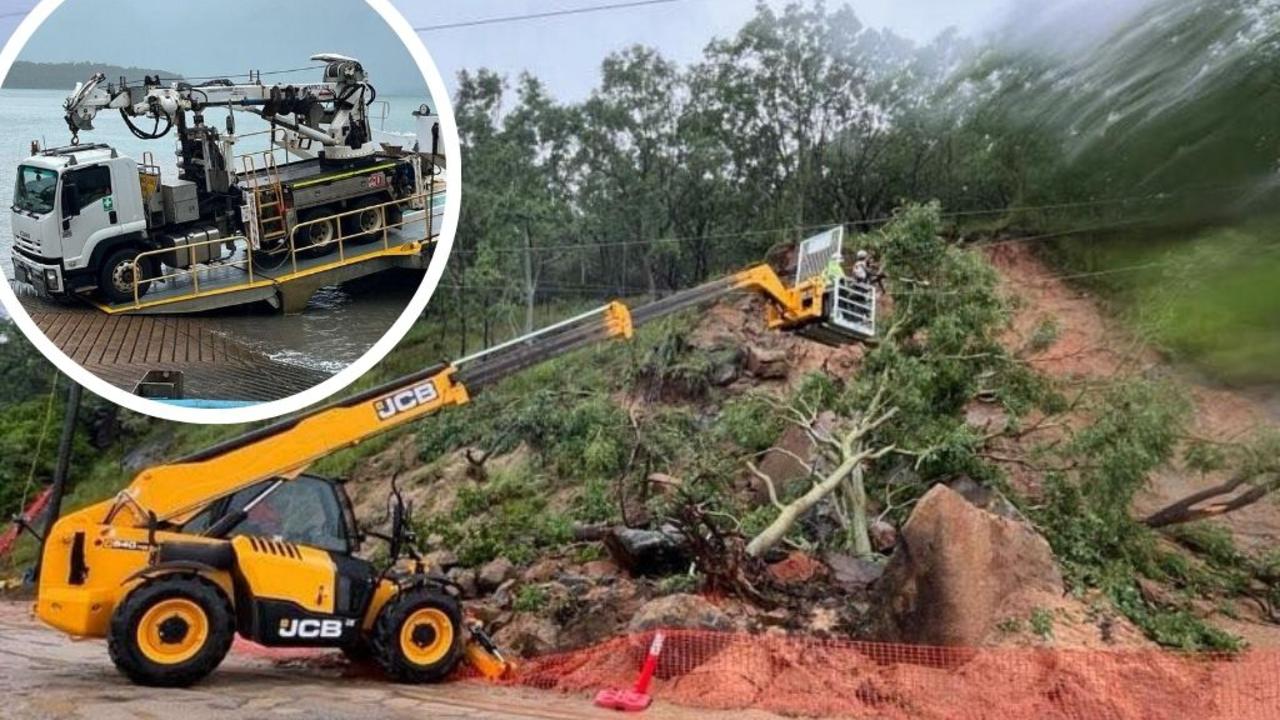
Recovery begins: Palm Island mayor calls for cyclone shelter
Despite having a landslide and its power and water cut, Palm Island is recovering well after days of intense weather. Read why its mayor is ramping up pressure on the government.
Read more

Townsville dodges major flood as hearts break for Ingham
Townsville residents have begun returning to their homes after a major flood warning was downgraded to moderate, while residents in Ingham are battling flooding of hundreds of homes, power outages and the loss of communications.
Read more

‘I was swimming’: Couple and newborn’s incredible rescue
With their possessions floating away, no power and food for their newborn baby, one North Queensland couple has told how they were rescued by a ‘floody legend’ in his tinny.
Read more

Townsville has ‘dodged a bullet’ for now, but more rain forecast
Rainfall has dramatically eased across much of North Queensland with ‘black zone’ residents allowed back home. But there are still warnings that isolated falls of up to 180mm are possible. LATEST, NEW PICS AND VIDEO
Read more
Road closures, power outages: FULL LIST
The Bruce Hwy between Townsville and Ayr has reopened but authorities warn motorists to limit their travel, with many suburbs entering their third day without power. Full list of road closures + power outages here.
Read more

2025 FLOODS: Burdekin Falls Dam spilling over, farms underwater
The Burdekin River has reached major flood levels and is on track to beat its 2011 record, trapping motorists on remote highways and triggering minor flood warnings below the dam.
Read more