
Residents rush for sandbags ahead of flood threat
LIVE COVERAGE: The threat of flooding caused plenty of Toowoomba residents to rush out for sandbags, despite a lack of immediate danger.
News
Don't miss out on the headlines from News. Followed categories will be added to My News.
** ROLLING COVERAGE OF WEATHER EVENT **
WHAT WE KNOW
- All state, Independent and Catholic schools between Agnes Water in the north, the NSW border in the south and west to Nanango are closed.
- 1000 homes without power after storm hits region
- Police say businesses "should think about closing after midday"
- DRENCHED: See how rain is affecting Toowoomba right now
- Sandbags for Southern Downs residents
- Rain washes out Toowoomba university
UPDATE: The threat of flooding caused plenty of Toowoomba residents to rush out for sandbags, despite a lack of immediate danger.
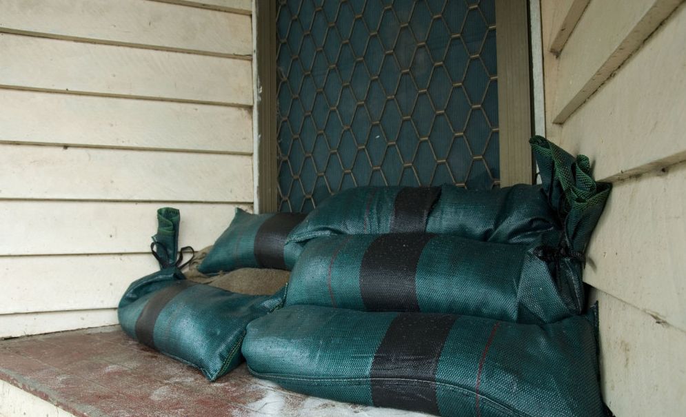
Toowoomba's State Emergency Service gave out roughly 300 sandbags today, making nearly 40 deliveries to people unable to drive to the depot on Hume St.
Group leader Frank Devlin said even the potential of flooding was enough for people to take precautions.
"We've done about 32 jobs today, and at this stage we've got another four or five deliveries to do," he said.
"We had about 15-20 crew members on today - probably about 300 (sandbags) we gave out, roughly.
"Most of the requests we've had are for sandbags, not because there's flooding but because it might flood.
"We'll be here until goodness knows what time tonight."
With no reported incidents of people crossing floodwaters, Mr Devlin said he hoped people were listening to advice from the SES and police.
"I think they may be starting to get the message," he said.
If you require sandbags or any other assistance, call the SES on 132 500.
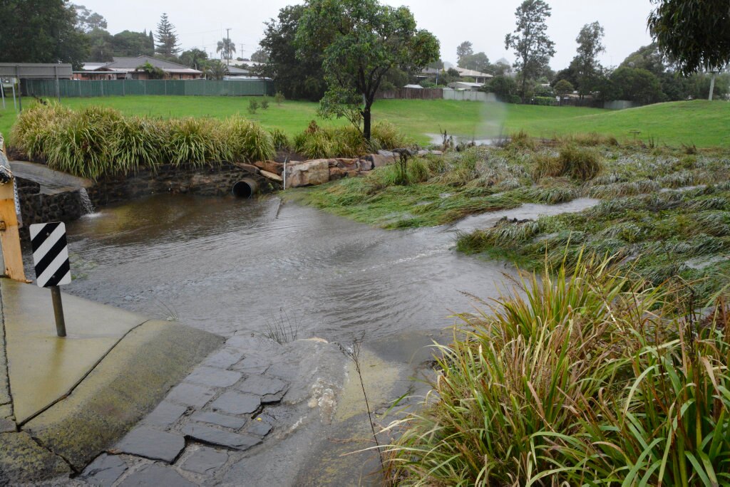
Nearly 60mm fell on Toowoomba in the 30 hours to 3pm today, a common theme across the Darling Downs.
xxo
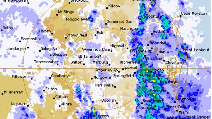
UPDATE: The Bureau of Meteorology has issued a new warning for south-east Queensland and the Darling Downs, as Toowoomba continues to be hit by heavy falls.
The warning, issued at 2pm by BOM, covers the Darling Downs, Wide Bay and Burnett regions, as well as the Granite Belt and Southeast Coast.
Toowoomba endured some heavy rainfall in the past 24 hours, but meteorologist Julian de Morton said the Garden City had avoided much of the flooding danger.
"We haven't seen the totals around the Darling Downs that some of the models were indicating," he said.
"We're still seeing widespread reasonable falls.
"We just haven't seen as many severe conditions that were predicted.
"A lot of the bands have been further east of the centre, so it's been aligned to the coasts."
Much of the damaging wind gusts predicted by BOM will be felt in the eastern Darling Downs, heading into the Lockyer Valley.
LIVE: Heavy rain and damaging wind gusts are currently affecting the Wide Bay and Burnett, Darling Downs and Granite Belt and Southeast Coast districts, the Bureau of Meteorology has warned.
At 10am EST Ex-Tropical Cyclone Debbie was located just south of Rolleston.
The system is expected to continue moving south-eastwards over the southern parts of the Central Highlands this morning, before tracking over southeast Queensland during this afternoon and evening.
Ex-Tropical Cyclone Debbie is expected to move off the far southeast coast overnight into Friday morning, with rainfall clearing offshore.
Toowoomba
The bureau's warning area is extending from north of Gladstone through to Stanthorpe and includes the Darling Downs and Toowoomba regions.
Official guages at Toowoomba Aerodrome in Wilsonton have so far recorded more than 40mm of rain although higher totals have been recorded elsewhere.
The temperature in Toowoomba has stayed low, about 21.6 degrees at 11am.
Wind gusts have been recorded up to 26kmh.
WEATHER COVERAGE
Impacts
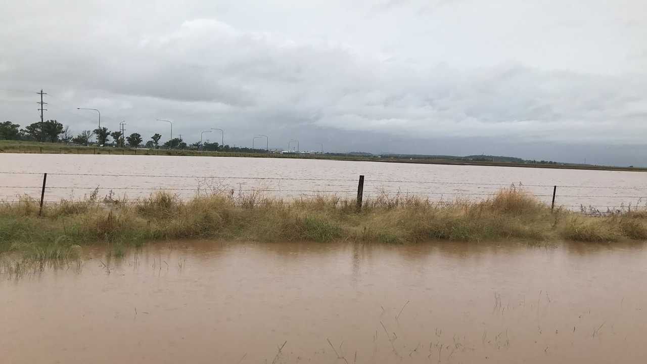
Ex-tropical Cyclone Debbie will continue to generate areas of very heavy rain over the Wide Bay and Burnett, Southeast Coast districts and parts of the Capricornia and Darling Downs and Granite Belt.
Currently the heaviest rainfall is occurring over much of the Wide Bay and Burnett region, and Southeast Coast districts.
Widespread 24 hour rainfall totals of 150 to 250 mm are expected, with significantly higher accumulations possible locally.
WEATHER ALERTS: Get real-time alerts on Toowoomba weather by clicking here and then FOLLOW TOPIC
Water surging at Lake Annand #Toowoomba #bigwet pic.twitter.com/5weDFpdYt2
— Iwan Jones (@IwanJ94) March 30, 2017
This rainfall will likely be very intense at times, leading to a risk of severe localised flash flooding.
Locations that may be affected include Gladstone, Kingaroy, Bundaberg, Brisbane, Sunshine Coast and the Gold Coast.
The focus for heavy rain will continue in far south-eastern parts of the state today.
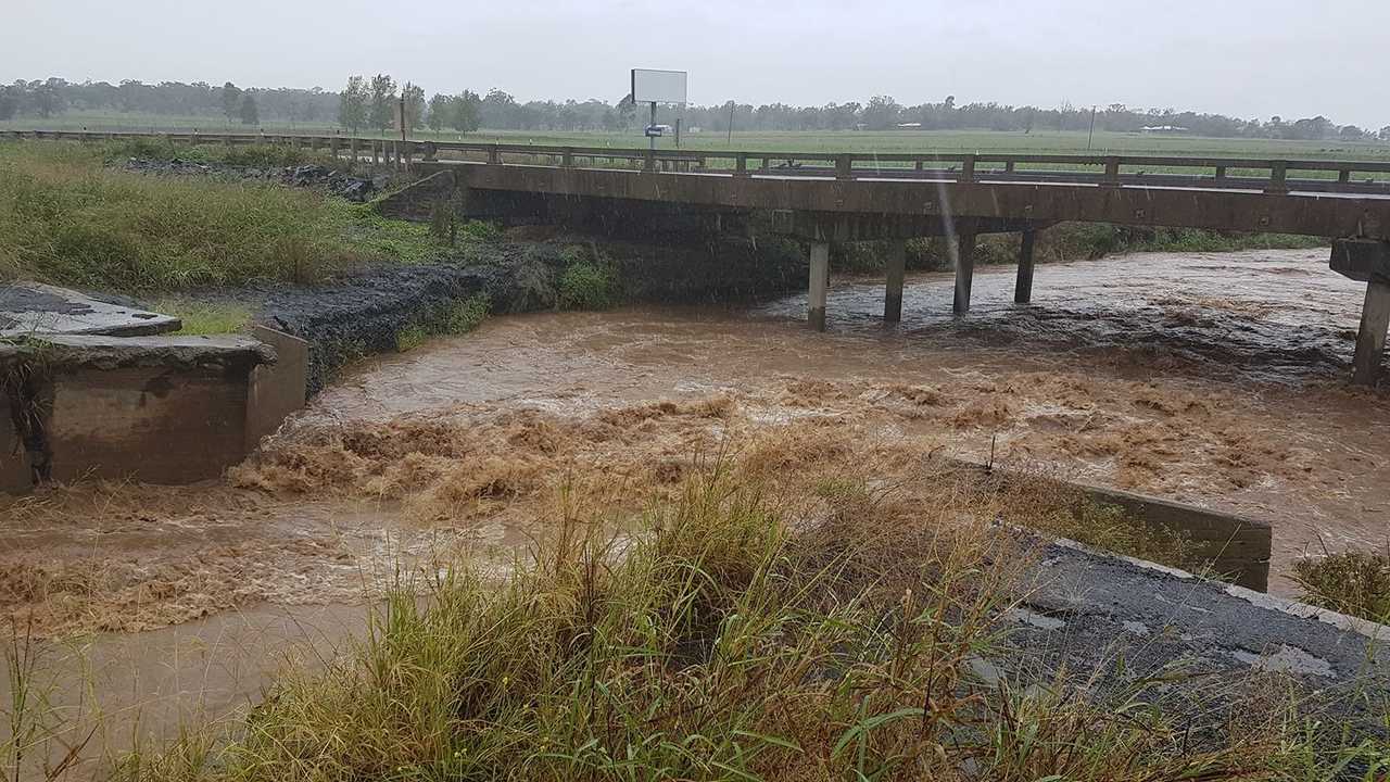
Widespread 24 hour rainfall totals in excess of 200 mm are possible, with isolated very heavy totals in excess of 400 mm possible, mostly around the higher ground in southeast Queensland.
This rainfall is likely to lead to major river flooding over a broad area and a flood watch is current for coastal catchments between Hervey Bay and the NSW border, extending inland to parts of the Maranoa and Warrego, and Darling Downs and Granite Belt forecast districts.
Damaging winds, with peak gusts of around 90 km/h, are occurring in the warning area, particularly about the coast and islands, between Rockhampton and Hervey Bay. The most likely area for damaging wind gusts will move south along the coast during today.
Destructive wind gusts, in excess of 125 km/h, are possible about the coastal fringe and elevated terrain of the Wide Bay and Burnett and Southeast Coast districts during today.
EARLIER: A severe weather warning is current for the Darling Downs and Granite Belt.
The Bureau of Meteorology warned heavy rainfall would move into the Darling Downs and Southeast Coast districts this morning.
This rainfall is likely to lead to major river flooding over a broad area and a flood watch is current for coastal catchments between Gladstone and the New South Wales border, extending inland to parts of the Central Highlands and Coalfields, Central West, Maranoa and Warrego, and Darling Downs and Granite Belt forecast districts.
The downpour in Toowoomba started about 1am this morning, with the official gauge recording 10mm in about an hour.
Residents in Mt Lofty reported 55mm of rain fell last night.
The bureau warned yesterday 150mm of rain could fall in Toowoomba.
Road alerts
- Hogg St
Residents have reported there is water over the bridge of Gowrie Ck at the end of Hogg St after the railway tracks.
- Warrego Hwy
Debris is affecting the Warrego Hwy. Both lanes affected southbound towards Troys Rd roundabout. Motorists are advised to proceed with caution.
Local Disaster Management Group
Toowoomba Regional Council says it is well prepared to respond, if and when required, to any situation across the region as ex-Tropical Cyclone Debbie tracks closer to Southern Queensland.
Toowoomba Region Acting Mayor Carol Taylor said council late yesterday afternoon would activate the Local Disaster Management Group to ALERT status. This is the first level of disaster response readiness.
Cr Taylor said the LDMG would coordinate with relevant emergency services and would monitor advice and information from the State Disaster Coordination Centre and the Bureau of Meteorology.
"Council, and in turn the LDMG, will follow established procedures for disaster planning if required," Cr Taylor said.
"The Bureau of Meteorology is forecasting between 70mm and 120mm of rain today (March 30) for Toowoomba.
"It is impossible to forecast exactly how much rain will fall in any given location. The forecast is for the system to move quickly through the region to the south-east by Friday, with little rain at present forecast for Friday. These weather events are extremely unpredictable.
"Our top priority is to ensure all residents are safe and well informed about the potential dangers from possible flood waters and high winds. It is better to err on the side of caution.
"We urge residents to please take note of the warnings and move quickly to ensure they finalise any last minute action to clear yards of any debris and secure outdoor or loose items on their property.
"It is a good idea to check on elderly or isolated neighbours and be prepared for the likely loss of electricity.
"Motorists are reminded to heed the simple message, 'If it's flooded, forget it'. Please observe any warning signs and drive to the conditions. Council's flood early warning systems in Toowoomba offer residents and road users additional safeguards in these events.
"Residents should be vigilant for any fallen powerlines or other hazards in the high winds."
In a life threatening emergency call 000 and for emergency flood or storm assistance, call the State Emergency Service on 132 500.
Listen to ABC Radio for relevant disaster information updates and warnings.
Advice about TRC road closures will be notified at www.tr.qld.gov.au/roadclosures.
Originally published as Residents rush for sandbags ahead of flood threat

‘Burn to learn’: Camp Oven King shares life’s passion at outdoor expo
Thousands of punters strolled through the Toowoomba Showground gates for the Outdoor Adventure Expo, keen to see the latest in camping and off-road gear, and to learn the classics from legends like Ron Wilson, the Camp Oven King.

Qld’s hidden multimillion-dollar Native Title claims battle
There are calls for the state government to help cash-strapped Queensland councils deal with the costs of covering the multimillion-dollar Native Title claims. Vote in our poll.

‘She loved him’: Stepfather found not guilty of molesting 10yo girl
A man accused of sneaking into his stepdaughter’s room late at night has been found not guilty of molesting her two years prior.

Man who allegedly tried to burn woman to death complains bail conditions ‘inconvenient’
She was left with severe and lifelong injuries, now her accused attacker wants to go camping and attend the footy.

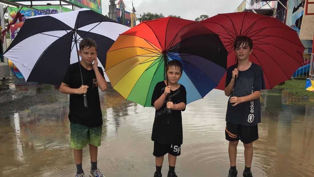
Three seasons: Downs to cop rain, frost and shine this weekend
A strong umbrella will be required for residents attending outdoor events on Saturday, with heavy falls set to hit the region. See the full weekend forecast here.

Lehrmann hearing twist: Lawyer will ‘refuse’ calls from police
A lawyer for Bruce Lehrmann has revealed why she will no longer take phone calls from police in relation to the former Liberal staffer’s rape allegations, in a key hearing that took a major twist.