
CQ town smashed by 117km/h winds
Destructive storms hit parts of Central Queensland overnight
Rockhampton
Don't miss out on the headlines from Rockhampton. Followed categories will be added to My News.
TUESDAY 6.30AM: THE clean-up will begin in Rolleston today, after cyclone-force winds wreaked havoc on the small town.
Showers and storms are set to continue across Central Queensland until Thursday.
UPDATE 8.25pm: AS THE rain tumbles down in Rockhampton, it appears that the most destructive storm cells have avoided the city.
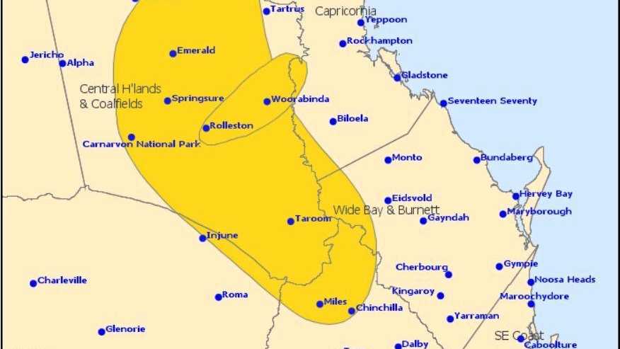
The Bureau of Meteorology said that there were now isolated severe thunderstorms moving towards the east coast and have shifted their warning area.
"While extensive severe thunderstorm activity has eased, redevelopment may occur across the Central Highlands and Coalfields and down through the southern Capricornia later this evening and into Tuesday morning," the BoM's latest warning said.
"Severe thunderstorms are likely to produce damaging winds, heavy rainfall that may lead to flash flooding and large hailstones in the warning area over the next several hours. Locations which may be affected include Marlborough, Sarina and Byfield.
"Severe thunderstorms are no longer occurring in the Wide Bay and Burnett and Darling Downs and Granite Belt districts and the warning for these districts is cancelled."
UPDATE 7.10pm: STORM cells are making their way towards the coast with the Bureau of Meteorology advising that the destructive storm was weakening but severe storms remained across the eastern interior.
Severe thunderstorms are likely to produce damaging winds, heavy rainfall that may lead to flash flooding and large hailstones in the warning area over the next several hours.
Locations which may be affected include Biloela, Blackwater, Baralaba, Marlborough, St Lawrence, Woorabinda, Theodore, Moura, Duaringa and Mount Morgan.
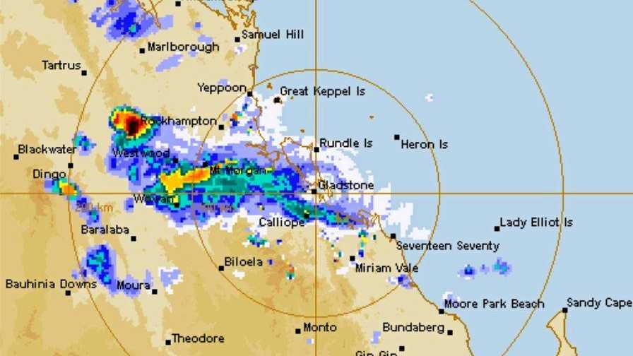
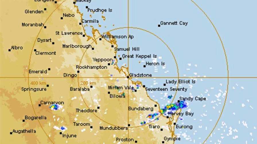
According to the rain radar, Rockhampton is set to miss the worst of the storms, which look to be passing to the west and south.
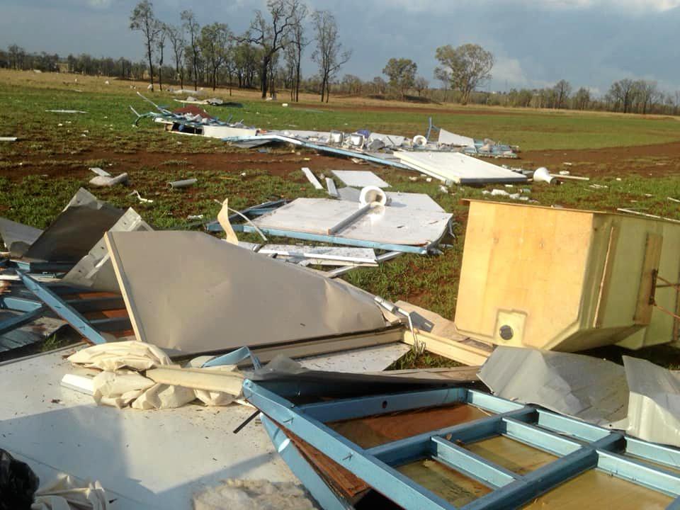
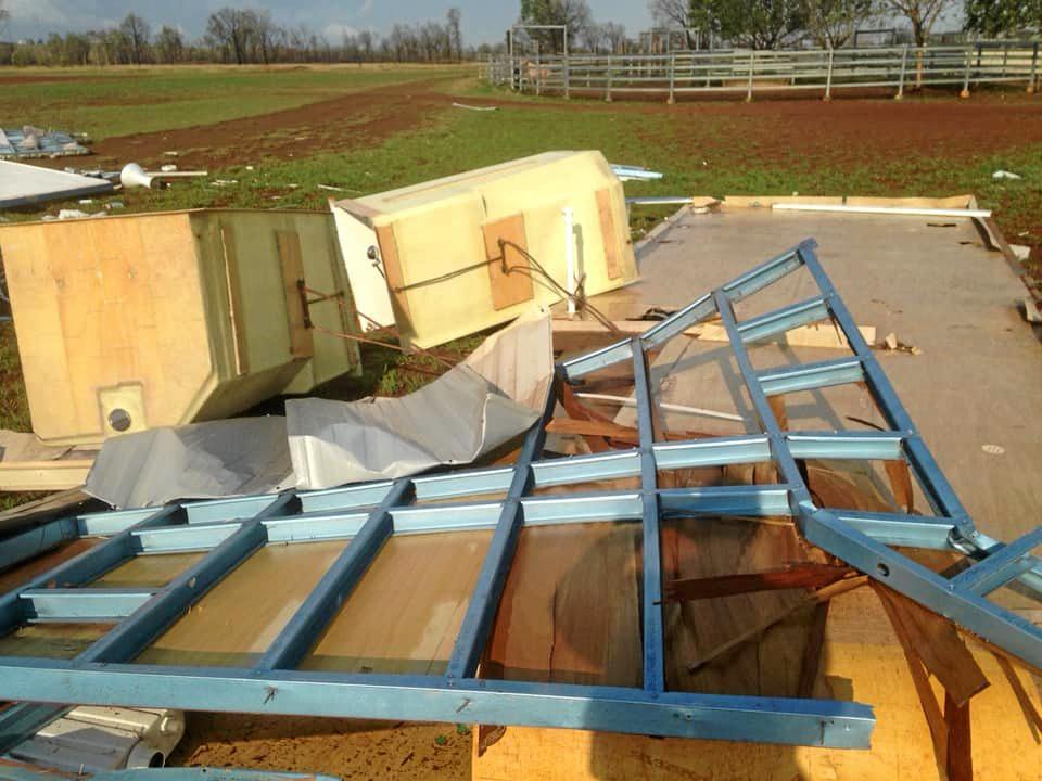
UPDATE 6pm: WINDS the equivalent of a Category 2 tropical cyclone have torn a path through Rolleston, a town south east of Emerald.
Dramatic pictures have emerged after the town was battered by wind gusts up to 117km/h during a 10 minute period when a storm cell passed through.
Rolleston Campdraft Association posted pictures onto Facebook of the remains of their shower block saying "need rain but not these wild storms".
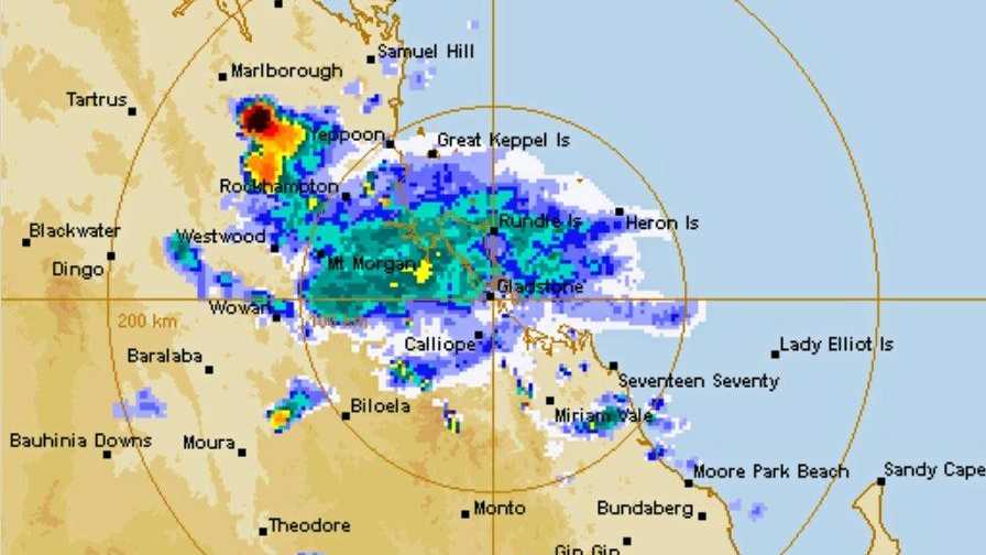
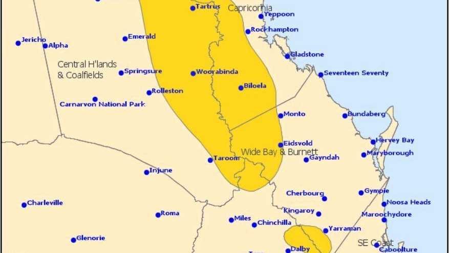
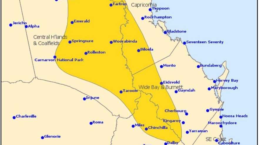
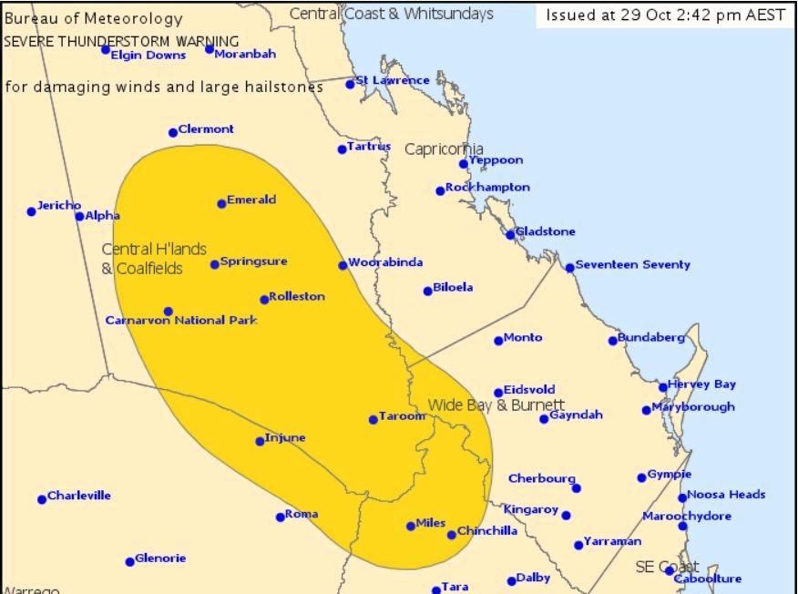
See below the latest severe storms warning map.
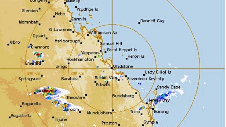
This is the latest rainfall radar.
UPDATE 4.50pm: 117km/h wind gusts were recorded during an intense 10 minute period at Rolleston airport at 4pm this afternoon as the CQ region prepares to be hit by a number of storms.
Sever thunderstorms are likely to produce damaging winds, heavy rainfall that may lead to flash flooding and large hailstones over the next several hours in parts of in parts of the Central Highlands, Coalfields and Capricornia.
The Bureau of Meteorology have released their latest warning map, noting in particular the destructive storms near Rolleston and Capella are moving north-east towards Woorabinda and Duaringa.
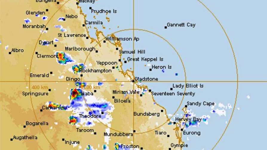
Other storm cells appear to be heading towards Dingo and Middlemount.
UPDATE 3.20pm: A SEVERE thunderstorm warning was issued by the Bureau of Meteorology at 2.42pm for people living in parts of Western Capricornia.
Severe thunderstorms are developing across the south-eastern interior and are likely to produce damaging winds and large hailstones in the warning area over the next several hours.
Locations which may be affected include Emerald, Blackwater, Taroom, Rolleston, Springsure, Injune, Capella and Carnarvon National Park.
Queensland Fire and Emergency Services advises people in warning zones to:
- Move your car under cover or away from trees.
- Secure loose outdoor items.
- Seek shelter, preferably indoors and never under trees.
- Avoid using the telephone during a thunderstorm.
- Beware of fallen trees and powerlines.
- For emergency assistance contact the SES on 132 500.
EARLIER: THE antidote to Capricornia's oppressive heat and humidity is on the way.
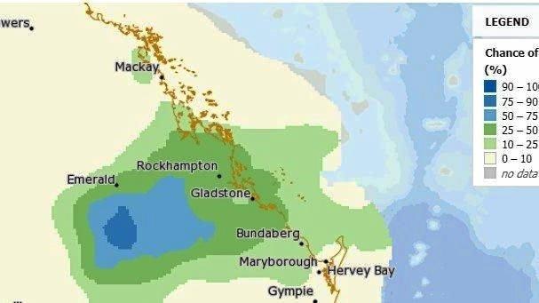
The Bureau of Meteorology predicts a chance of thunderstorms and rain soaking a large area, north to Marlborough, west past Emerald, east to Yeppoon and south to Agnes Waters today.
Areas in Capricornia are set to receive between 10 and 50 mm of rain.
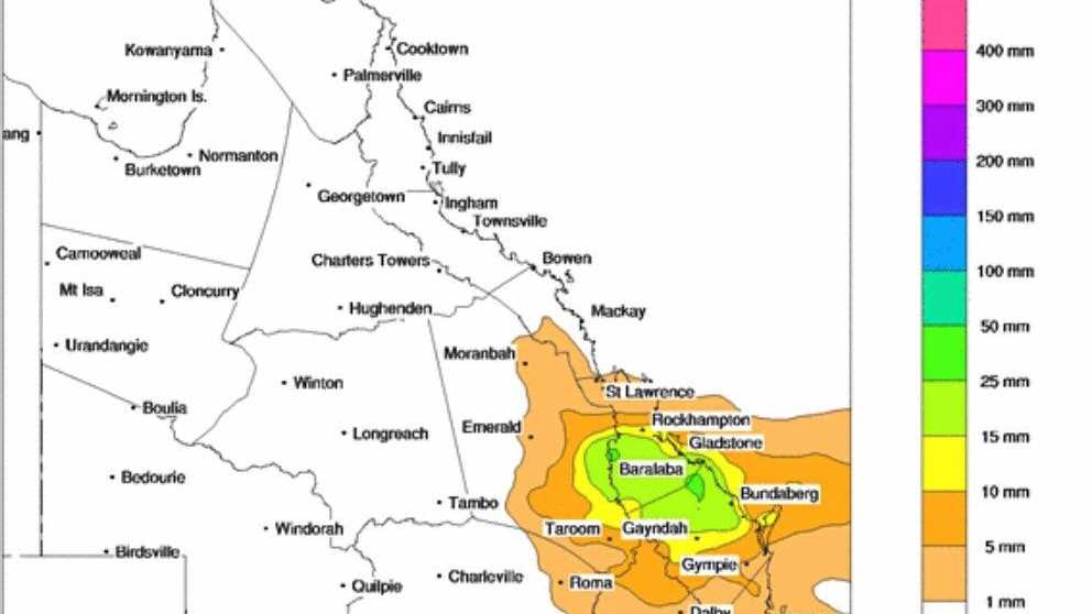
Thunderstorms are likely over inland parts, possible severe with heavy falls with the area south of Emerald, near Springsure and Rolleston most likely to receive decent rain.
Storm warnings are anticipated to be announced later this afternoon and The Morning Bulletin will keep you up to date with rolling coverage.
Yesterday, Rockhampton sweated through humid, hazy conditions with a maximum temperature of 38.2°C.
Relief arrived after 10.30pm last night with the rain gauge at the Rockhampton Airport gathering 2.2mm and another 0.2mm after 9.30am this morning.
READ: Showers set to cool off scorching CQ
Today's CQ forecast:
Biloela: Showers. Storm likely. 29°C
Gladstone: Shower or two. Possible storm. 28°C
Rockhampton: Shower or two. Possible storm. 31°C
Yeppoon: Shower or two. Possible storm. 27°C
Tomorrow's Capricornia forecast:
Cloudy. High (70%) chance of showers. The chance of a thunderstorm. Winds east to south-easterly 15 to 20 km/h becoming light before dawn then becoming easterly 15 to 25 km/h early in the morning. Overnight temperatures falling to between 19°C and 22°C with daytime temperatures reaching the mid to high 20s.
Did you get any rain?
Send in your rain totals and pictures to tmbully@capnews.com.au
Originally published as CQ town smashed by 117km/h winds

State gov blindsided as PM lifts US beef ban
The state government has slammed the lack of consultation around a federal decision to lift biosecurity restrictions on US beef imports with Tony Perrett saying he learnt of it on the radio.

Girl, 12, granted Supreme Court approval to have abortion
A 12-year-old Queensland girl has been granted permission by the Supreme Court to have a surgical abortion after her mother was prevented from approving it on her behalf.

Who owns Qld’s farms: Biggest investors, landholders named
Meet the farmers, families and funds who own Queensland’s finest farms, from cropping gems in the south to sprawling stations in the north. SEE THE FULL LIST

‘People before crocs’: Premier says ‘mighty Fitzroy’ safe for Olympics
A technical review of the Fitzroy River’s ability to hold Olympic rowing in 2032 has begun with the Premier adamant it is ‘good enough for international athletes’.

‘Irreplaceable’: Fourth victim in crash which killed dad, kids, mourned
The fourth victim tragically killed in a crash which claimed a dad and two children is being remembered as someone who “brought light and joy” to many.

Wild wind, lightning, rain: Flights stopped as ‘microburst’ smashes SEQ
Parts of Brisbane, Logan and Ipswich have been hit with wild weather as a large band of rain with isolated storms ripped through the southeast on Wednesday afternoon.