
Parts of Qld told to brace for heavy rainfall over next seven days
Parts of Queensland are enduring their wettest March since 2011, as record-breaking rainfall triggers several flood watches and warnings, with forecasters warning it is far from over.
QLD News
Don't miss out on the headlines from QLD News. Followed categories will be added to My News.
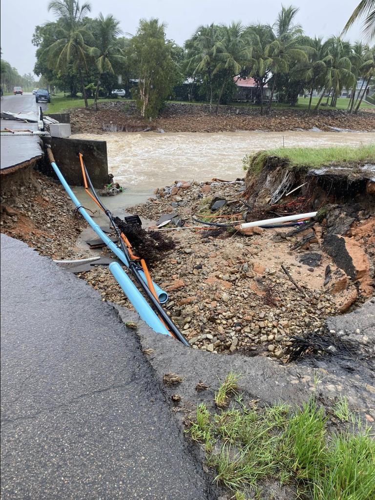
North Queensland has been hit with record-breaking rain, delivering the region its wettest March since 2011, with the threat of more to come.
Heavy rainfall that could lead to riverine flooding is expected for much of Queensland over the coming week, with the Bureau of Meteorology issuing several flood watches and warnings in anticipation of the weather event.
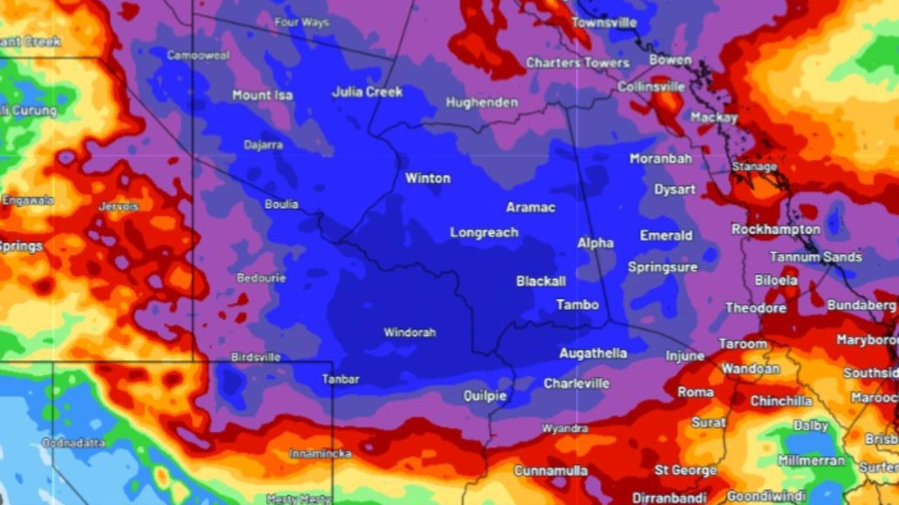
An entire year’s worth of rain could fall over western Queensland this week, Weatherzone reported, which could lead to huge flooding concerns that could last months.
“Some places in western Queensland could see six to 12 months’ worth of rain this week,” Weatherzone reported.
“Longreach’s annual average is about 430mm and some models are hinting at accumulated weekly totals of around 400mm in that region.
“The annual averages at Windorah (300mm) and Charleville (490mm) are also in the range of what some models are anticipating this week.”
The Bureau of Meteorology has issued a number of warnings across much of inland Queensland on Monday as the low pressure trough continues to bring heavy rainfall to the regions.
A major flood warning has been issued for Quilpie, with major flooding possible from Monday afternoon. River and creek level rises across the upper parts of the Bulloo River have been observed.
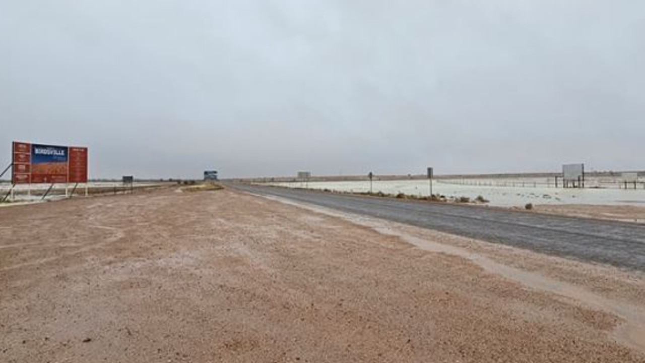
River levels are currently at 4.72 metres and rising, with further rises likely with forecast rainfall. Heavy rainfall and thunderstorms are forecast to impact Winton and Birdsville over the next several days, with a minor flood warning issued for the Diamantina River. Both towns could see minor flooding overnight into Tuesday.
Senior Meteorologist Miriam Bradbury told The Courier-Mail the northern and western parts of the state could see extensive showers and storms develop from Sunday night.
“For the next couple of days those heavy falls are likely across inland parts of the state and the northwest, including parts of the gulf country as well,” she said on Sunday.
“We are also likely to see more heavier falls redeveloping around parts of the northern tropical coast from later this evening.
“We are still going to see showers pushing down around the central and southeast coast, they are likely to be patchier and not bring the risk of those heavier falls.”
She said that the weather event stood out from recent rainfall along the coastal regions because it would impact inland regions including Birdsville, Quilpie, Charleville and Longreach.
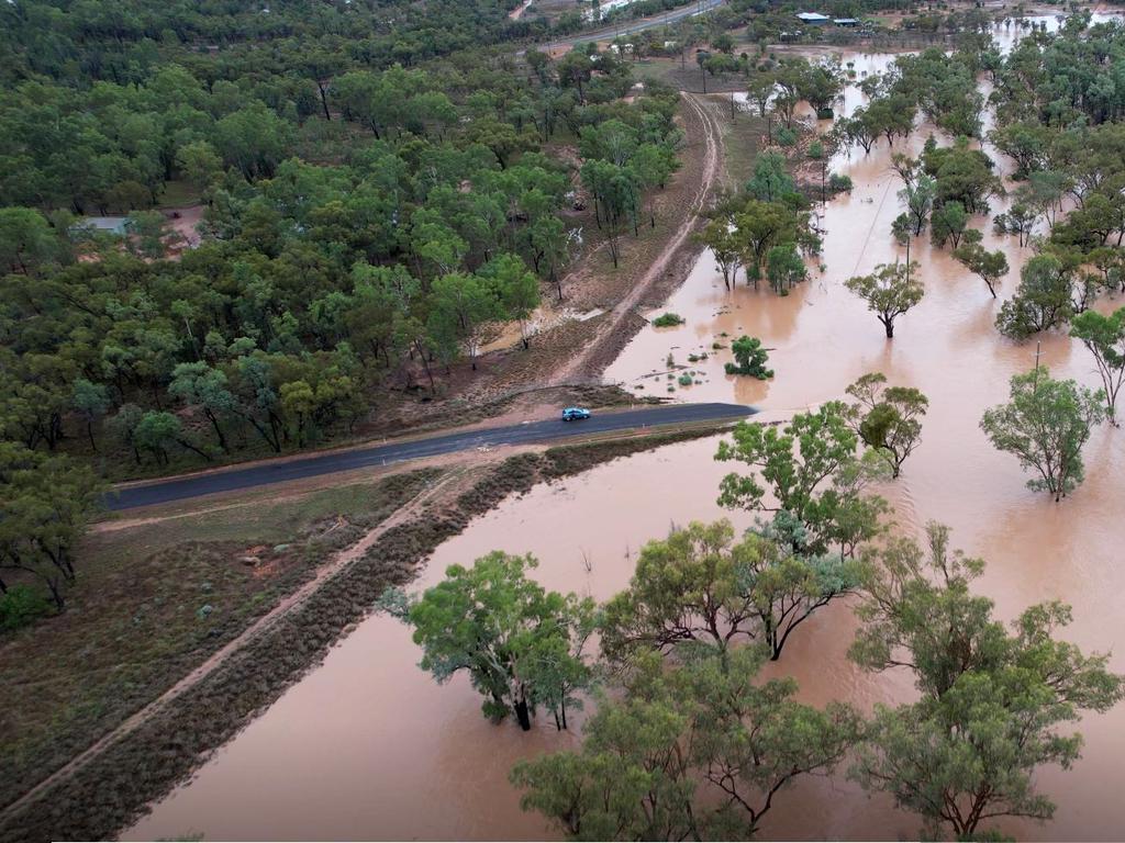
“For many of those inland areas, this will be the wettest period of the season for them. Outback highways are much fewer and further between, so this kind of rainfall could see roads become muddy and detours,” she said.
“It’s also likely to have big impacts on agriculture and industry out that way as well.”
North Queensland communities across Townsville and Cairns could experience widespread rainfall, however the totals are expected to be less significant than those recorded during the January 2025 flood event.
“It’s certainly going to be another challenging time for communities up north given that they have seen several waves of significant flooding so far. For that north tropical coast, this week doesn’t look as wet as the event we had in January and February, but that’s not to say we’re not going to see a river response,” she said.
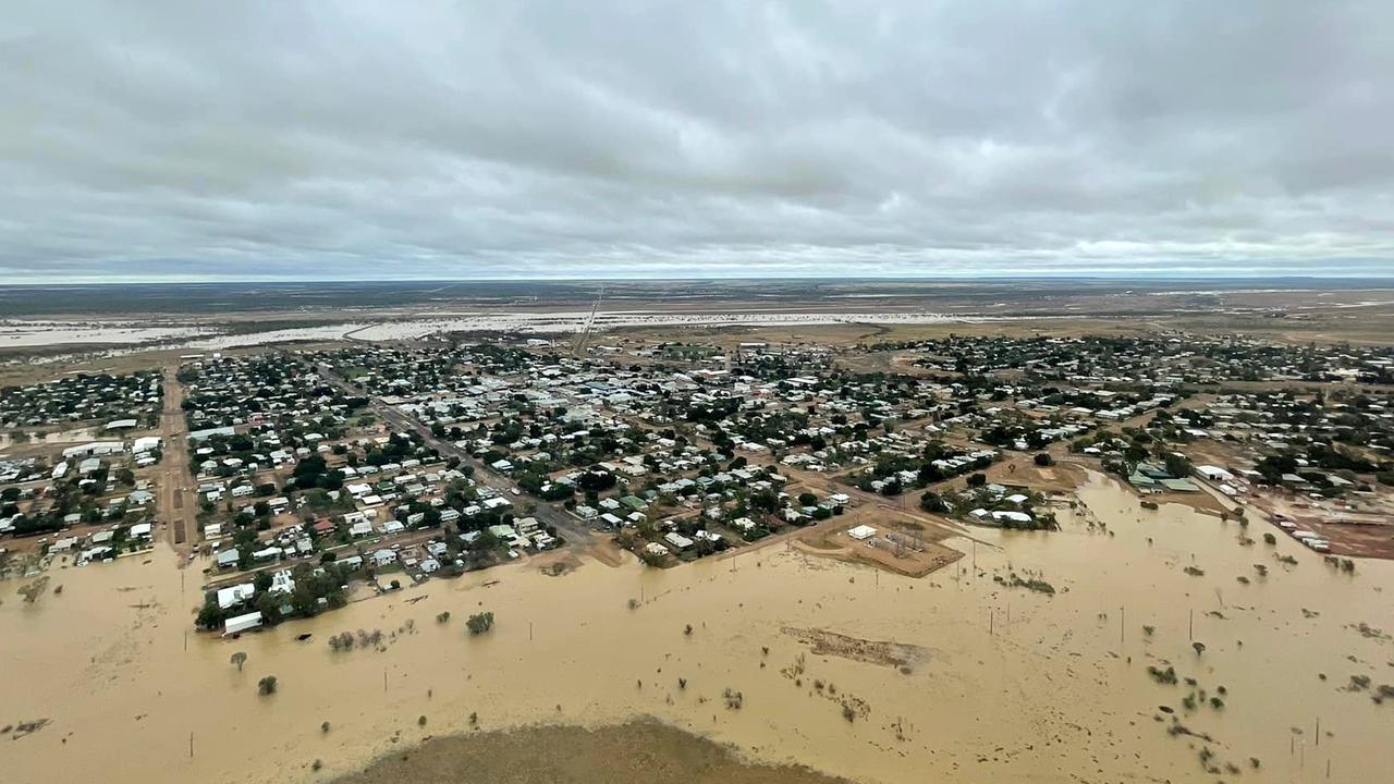
“The ground is so saturated over part of that state, the rivers are already swollen because they have had so much rainfall. It’s going to take very little further rain to see a quick response from the rivers.
“The situation is much better than it was a few weeks ago but it’s yet another burst of wet weather and flooding concerns for these communities that have already been so impacted by this weather so far this season.”
The inland areas and the northern tropical coast could see falls of 100mm to 200mm, with some areas potentially seeing up to 300mm.
“We’ve got a low pressure trough lying across those inland areas. The low pressure trough pulls in moisture and fuels any showers that develop. Exactly where that low pressure trough moves will determine where those falls lie,” she said.
“Our message to the communities is it’s going to be a wet week, we are expecting flooding to develop over the coming days.
Inside the catastrophic flood that left North Qld town of Ingham underwater for a week
“Right through our forecast period of seven days, we are still expecting to see moderate rainfall totals. Even out to Thursday, Friday, Saturday and Sunday we may still see moderate rainfall with localised heavy falls affecting parts of northern and north east Queensland.
“The risk of the heavy falls will begin to ease this time next week. Unfortunately this isn’t a short-lived event it’s likely to be lasting the next few days.”
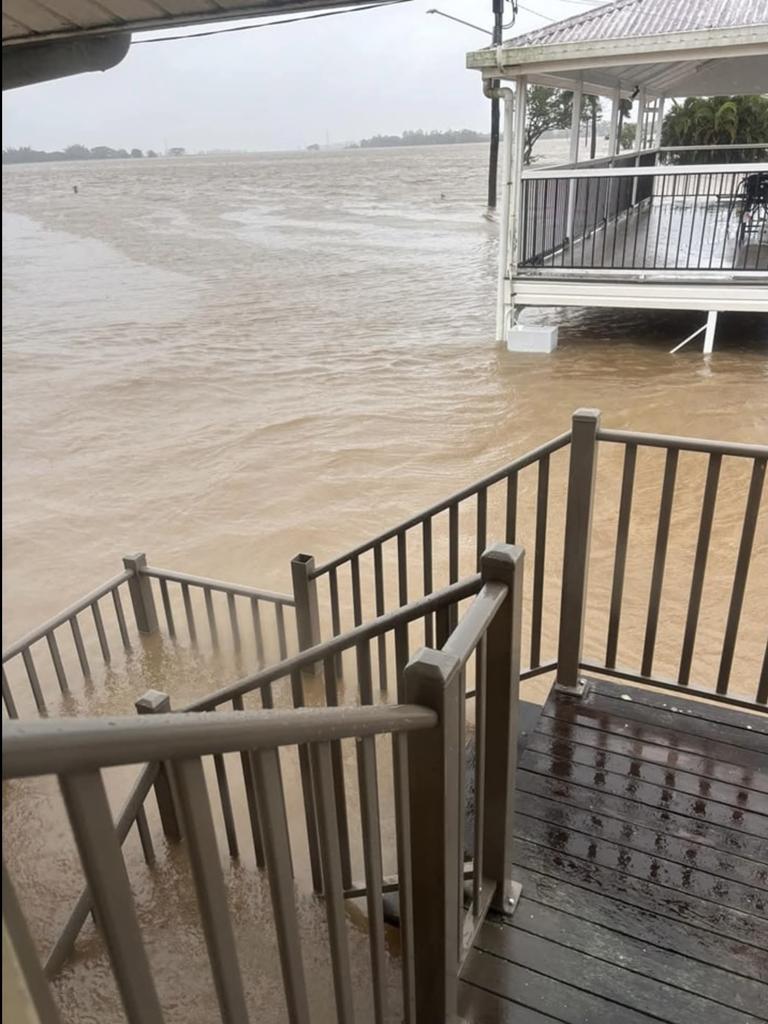
Townsville has recorded 762mm of rain since the start of the month, beating the previous record by almost 100mm.
“It’s well and truly on its way to breaking its annual record,” a Bureau of Meteorology spokesman said.
The spokesman said the concentration of rain has been within a “fairly small” area.
“Between Ingham and Ayr, which is traditionally the driest part of the tropics,” he said.
Flood watches are active for parts of Lake Eyre Basin Rivers and Gulf of Carpentaria Rivers, while minor flood warnings have been issued for the Herbert River, Tully and Murray Rivers, Ross and Bohle Rivers and the Diamantina River.
More Coverage


Originally published as Parts of Qld told to brace for heavy rainfall over next seven days
Haas mum’s shock move in triple-fatal crash case
Broncos star Payne Haas’s mum, who is accused of killing three people in a horrific Gold Coast hinterland crash, has made a shock move in bid to resolve the matter, a court has heard.

Roads, rail, housing: How Qld will benefit before and after the Games
Millions of Queenslanders will have access to faster, more frequent and better-connected rail services and an upgraded Bruce Highway, while thousands of new homes will be available after the athletes leave. FULL DETAILS
Brisbane City Council March 25 live blog
Council has come under fire for moving Question Time because the Lord Mayor was at the 100-day Games review launch. But a Greens councillor was absent for a protest. LIVE BLOG

LOCKED IN: Main stadium confirmed, list of Brisbane ’32 venues revealed
A new 63,000-seat stadium at Victoria Park is in, there will be a new national aquatics centre, and a surprise new arena as the final 2032 Olympic and Paralympic Games venues are revealed.
Man allegedly stabbed mother to death before trying to fly to Japan
Police allege a man stabbed his mum to death and casually washed his hands at a neighbour’s tap before buying a flight to Tokyo and fleeing to the airport, in a horrific suburban killing.
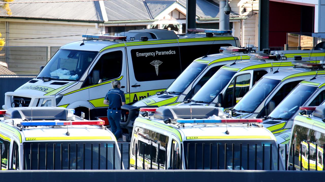
Minister’s response as 180+ calls to ambos left pending in one weekend
More than 180 calls to the Queensland Ambulance Service were left “pending” over the weekend, a whistleblower has claimed.