
‘Leave or stay’: Concern for islands, bay communities as Alfred homes in
South East Queensland residents have been urged to prepare now for the impending arrival of Tropical Cyclone Alfred, which is expected to make landfall as a Category 2 system. LATEST UPDATES

QLD News
Don't miss out on the headlines from QLD News. Followed categories will be added to My News.
Millions of Queenslanders are being told to prepare amid warnings of the first cyclone to cross the state’s southern coast in half a century.
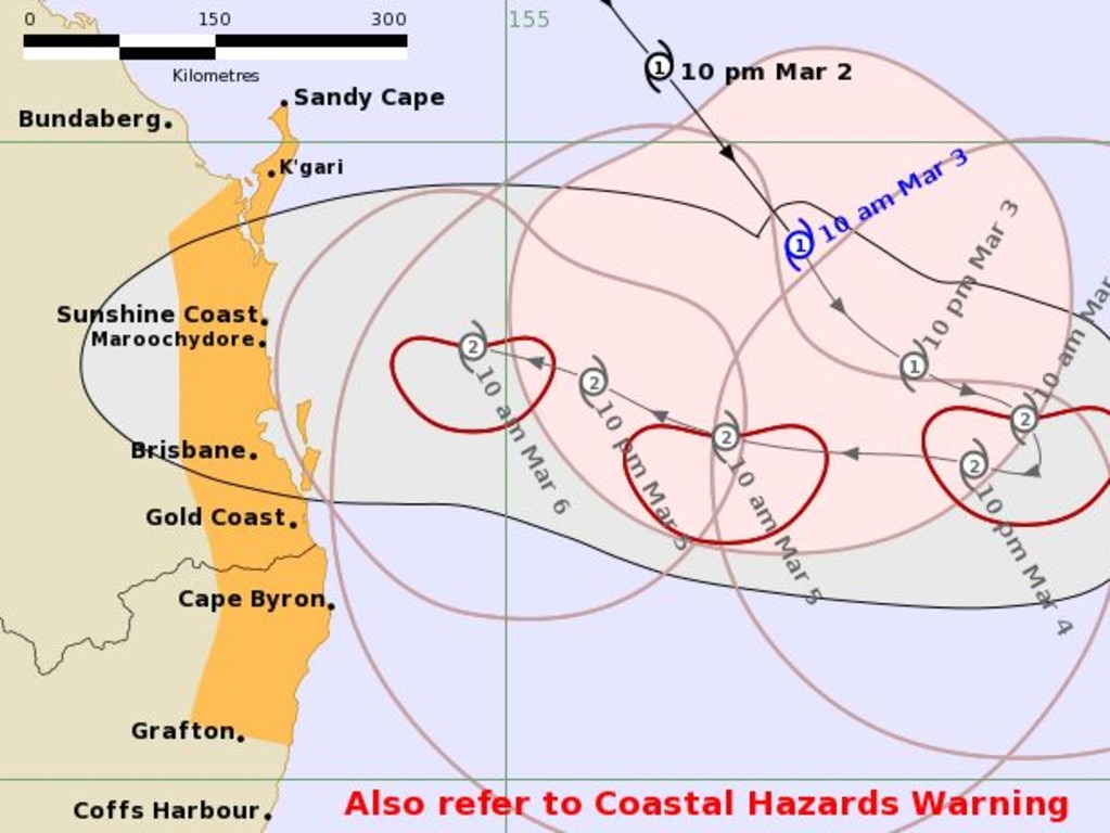
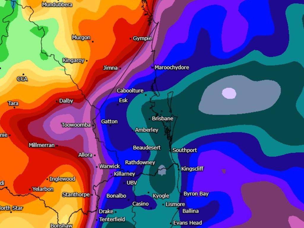
Tropical Cyclone Alfred could make landfall in South East Queensland by Thursday as a category 2 system – packing gale-force winds and up to 600mm of rain.
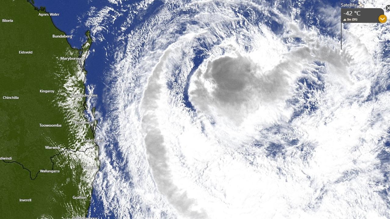
In its latest report, at 4.46pm on Monday, the Bureau of Meteorology said Alfred is a category 1 system about 500km east northeast of Brisbane and 480km east northeast of Maroochydore, heading southeast at 14km/h.
BE PREPARED: CYCLONE SAFETY GUIDE
“Tropical Cyclone Alfred, Category 1, is currently moving southeast but is expected to slow and turn west towards the Queensland coast from Tuesday onwards,” the Bureau’s tracking update read.
“Alfred is expected to intensify to a Category 2 cyclone Monday night as its south-eastwards movement slows. Alfred’s intensity may fluctuate between category 1 and 2 while it remains off the coast during Tuesday and Wednesday.
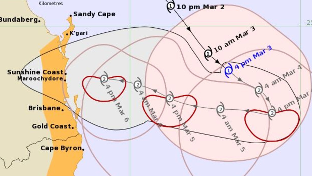
“As it approaches the coast on Thursday, Alfred is expected to maintain intensity as a category 2 cyclone and make landfall between Brisbane and Sunshine Coast late on Thursday or Friday morning.”
Gales with damaging winds to 120km/h are expected along the coast from Tewantin to Grafton in NSW, as well as a large and powerful swell and abnormally high tides.
“Gales with damaging wind gusts to 120 kilometres per hour are expected to develop along the southeast Queensland and northeastern New South Wales coastal fringes and island communities between Tewantin and Grafton during Wednesday. Gales may extend further north from Tewantin to Sandy Cape from late Wednesday or early Thursday,” the report said.
“Heavy rainfall is forecast for southeast Queensland and northeastern New South Wales from Wednesday. heavy to locally intense rainfall which may lead to dangerous and life-threatening flash flooding may occur near and south of the cyclone centre as Alfred approaches the coast late on Thursday or early Friday. Flood Watches have been issued for these areas.”
The Bureau issued its first official “cyclone advice” for Queensland over Alfred Monday morning.
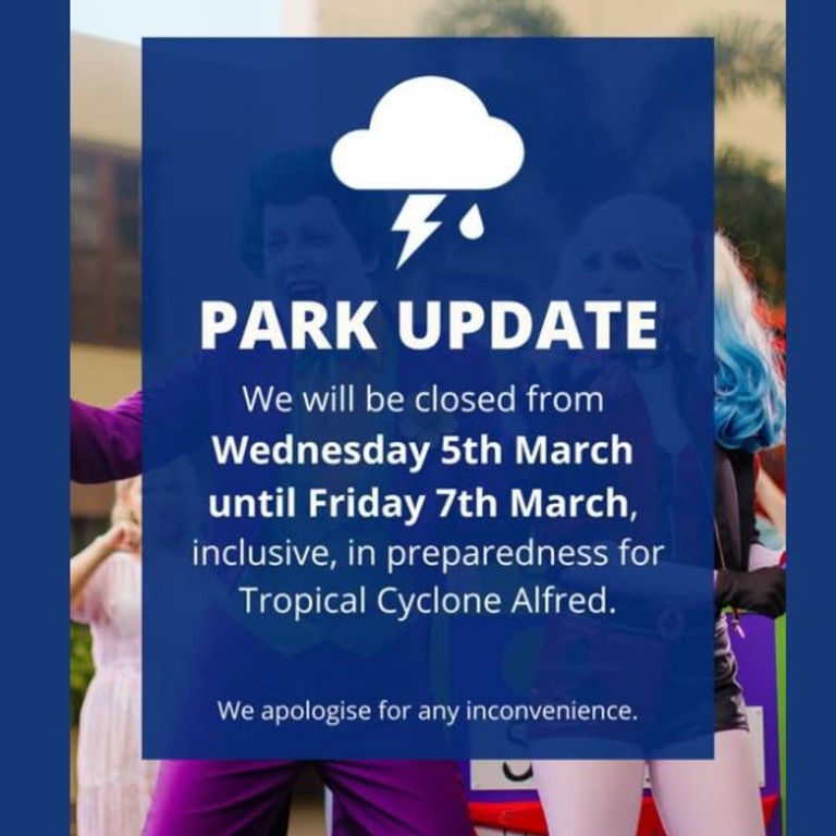
Just after 5pm Monday Village Roadshow announced it would close all of its attractions and theme parks for three days, starting Wednesday in preparation for the severe weather.
Queensland University of Technology put out a statement on Monday night to advise all learning and teaching would transition to online for Wednesday, Thursday and Friday this week, to keep staff and students safe.
Meanwhile many insurance companies put an embargo on people taking out new policies or changing policies, including; AAMI, RACQ, Bank of Queensland, Allianz, Suncorp, NRMA, Budget Direct and QBE.
Speaking at the Kedron Emergency Services Complex on Monday, Premier David Crisafulli said weather modelling overnight had indicated the likelihood of a cyclone crossing the coast had increased.
“My message to Queenslanders today is please be prepared,” he said.
“We are putting all the preparations in place and we are asking all Queenslanders to do the same.
“But we are dealing with a very heavily populated part of the state, a state that hasn’t seen a cyclone for many years – in fact many decades – get this close to the coast, or predicted to.
“So it is important that Queenslanders absorb those messages so we can continue to relay them to the state.”
Mr Crisafulli said Tropical Cyclone Alfred was about 450km east of Brisbane and had been downgraded to a Category 1.
But he said it modelling showed it would likely intensify again to go back to a Category 2.
RELATED: 1.88m properties in path of cyclone Alfred’s fury
Mr Crisafulli said there will be three stages to the weather event – big surf and erosion, damaging winds, and flooding.
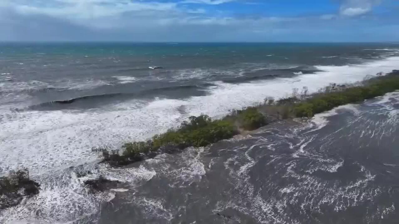
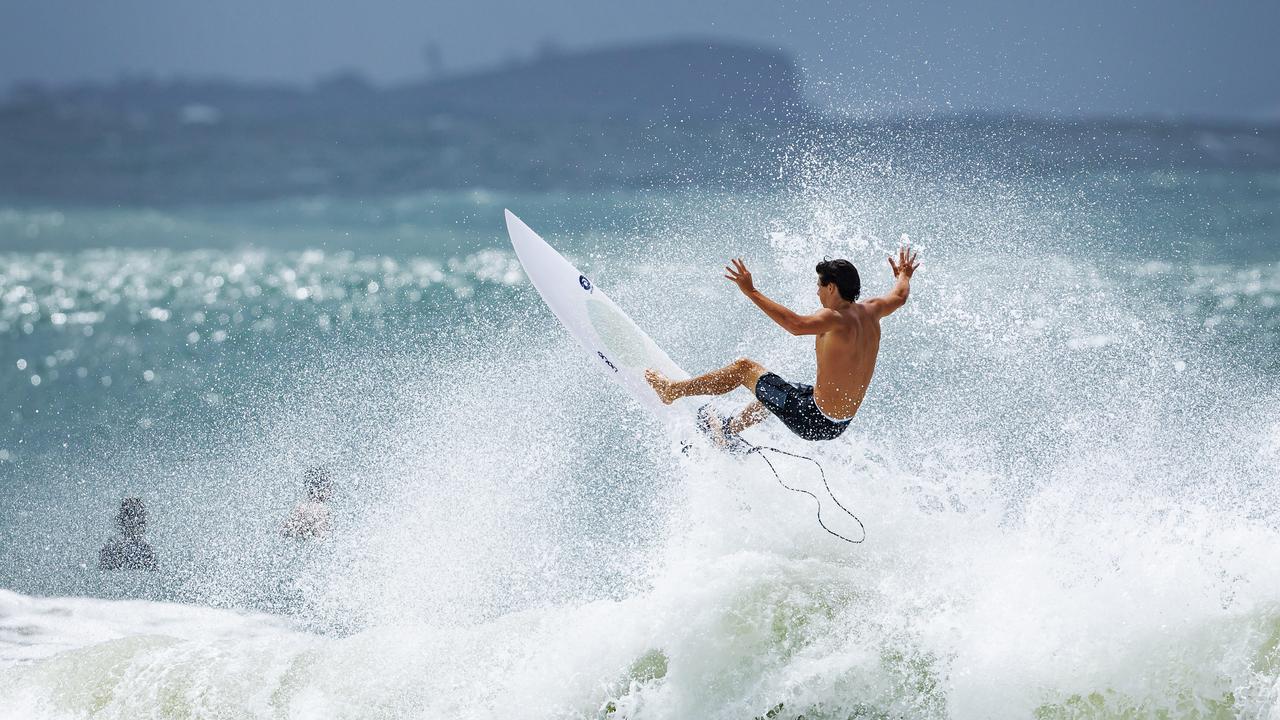
Large swell with waves larger than 4m were expected to be recorded off Brisbane this morning.
Mr Crisafulli said the immediate priority was islands and bay communities.
“Anyone who lives on those bay islands … we are asking them to begin – with earnestness – to start making their plans and considerations,” he said.
“Ferry services are continuing at the moment but that could change in the very near future.
“We’re asking people who live on those islands to make a conscious decision … to either leave or stay.
“It is important they make that decision fairly soon because that window will close.”
Mr Crisafulli said they are using the window to prepare island communities with generators and health care workers in the event they are needed.
The second immediate priority areas were low-lying areas on beach fronts or on canals, with particular concern for Golden Beach on Sunshine Coast.
“Because the timing of that crossing remains variable, there is the prospect that it could cross on a high tide.
“That would provide a real complexity, that would provide some storm surge issues.
“Storm surges are a significant concern.”
Mr Crisafulli said he had spoken with the Prime Minister and Opposition leader, while there was close Australian Defence Force communication through lead liaison manager Denis Sweeney.
Mr Crisafulli expressed desire for three levels of government to work together to give people confidence that the cyclone was being well planned.
Having recently returned from floods in North Queensland hometown Ingham, Mr Crisafulli said it was important Queenslanders saw government officials taking disaster recovery seriously.
“And if you do that preparation, you minimise the need for your recovery, but whatever occurs, we’ll be there for the long haul,” he said.
“I’m very confident Queenslanders will get through it.”
He said Queensland Police, fire services and Ergon were prepared to move personnel from northern communities outside the impact zone, including those that were blasted from last month’s floods.
“Councils who were getting help from councils who are in the firing line now are already returning the favour,” Mr Crisafulli said.
“I think that shows a lot about the way that people work together in events like this.”
Mr Crisafulli said recovery from impacted North Queensland communities would not be forgotten in the wake of TC Alfred.

“We are focused at both ends of the state, and they’re at different stages.
“One’s picking up the pieces and doing it with true grit and determination, the other, is heeding the warnings and getting ready for whatever comes their way.
“One thing’s for certain, it’s a testing time of year, but it’s a state that’s full of people with a hell of a lot of ticker.”
Mr Crisafulli said he urged Seqwater to communicate with the community when dam releases would occur as huge amounts of rain are expected to drop on the region.
It comes after a Commission of Inquiry into the deadly Brisbane 2011 floods found the dam gates were opened at the wrong time, contributing to the city’s inundation.
Mr Crisafulli said he has asked Seqwater to communicate any dam releases with the community.
“Seqwater has procedures they have to follow following the Commission of Inquiry,” Mr Crisafulli said.
“I’m urging them to be upfront with people, explain what they are, explain what those percentages are, and when that occurs.
In a statement, a Seqwater spokesman said the Flood Operations Centre has moved to ‘Alert’ status and is working to prepare for “wet weather-related impacts”.
Wivenhoe Dam is at 87 per cent capacity, with Somerset Dam at 80 per cent, and North Pine Dam at 52.9 per cent, with the overall SEQ Water Grid storage capacity currently at 85 per cent. There are no planned releases at this stage.
Mr Crisafulli said the opportunity for island residents to leave could close within the next day or so.
“We are pre-deploying assets and people into those areas with the knowledge we may not be able to get somebody there by tomorrow.”
Bureau of Meteorology meteorologist Sue Oates said the system is currently moving in a south-easterly direction at 20km/h, but is expected to turn in the next 24 hours.
Ms Oates said there were signs the system could re-intensify to a category 2 cyclone as it heads toward the coast, potentially crossing on Thursday or Friday.
Damaging winds were expected to set in from Wednesday.
“As the system moves closer to the coast … those winds are possible through Thursday and into Friday,” Ms Oates said.
Ms Oates said heavy to intense rainfall was also expected in South East Queensland areas, bringing an increased risk of flash flooding and the likelihood of major flooding.
“We’ve currently got a Flood Watch current for areas from around the Bundaberg area south to the border – that includes catchments from the Mary River, through the Sunshine Coast rivers, includes the Brisbane River catchment, and down to our border catchment areas of the Logan and Albert Rivers,” she said.
“This situation continues to be an evolving citation and we advise communities to maintain an awareness of the current warnings.”
Mr Crisafulli said additional workers were on standby in areas across the state.
He said the government had met with telecommunications companies to speak to them about them providing extra capacity to put emergency messages out.

“There could come the time we need to send out many millions of text messages in a very short window and it’s important the telcos are able to do that as quickly as they can,” he said.
Mr Crisafulli urged all Queenslanders to speak to their colleagues and neighbours to make sure they were aware of the cyclone.
“It is important that everybody knows that this is a serious impact and the modelling does show that it is likely to cross the coast and therefore we want people to be as well prepared as they can be,” he said.
Schools will be open tomorrow and Mr Crisafulli said the government would update Queenslanders every afternoon about any potential closures.
He said the likelihood of schools closing was “very strong”.
“You won’t get a mad scramble where in the morning you’ll get a frantic message that school is closed.
“But we’re not at that stage yet, school is open tomorrow.”
He said people could log on to closures.qld.edu.au to check.
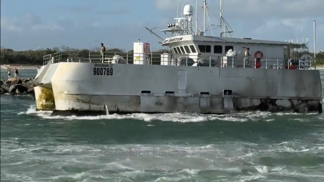
Mr Crisafulli said shipping operations off Mooloolaba had been suspended.
He said there were three cruise ships off the Queensland coast and two were looking for alternate ports. One would come into the Port of Brisbane and offload passengers.

All CityCat and ferry services will be suspended from tonight until further notice so the vessels can be moved to safety.
According to Brisbane City Council, 11 CityCats will be removed from the water and placed on hardstands while the remaining 16 will be placed inside protected docks.
The five KittyCats will be securely moored at a marina.
The last CityCat services will depart Northshore Hamilton and University of Queensland at 10.15pm tonight and the last KittyCat cross river services will leave by 11.40pm.
The 22 terminals between UQ St Lucia and Northshore Hamilton will be closed at midnight tonight.
Mr Crisafulli said airlines were working with the Bureau of Meteorology and at this stage would remain open.
Amity Trader Barge and Ferries have advised the final passenger ferry from Coochiemudlo Island in Moreton Bay will leave at 6.45pm on Tuesday and resume on Friday, weather permitting.
State Emergency Service chief officer Mark Armstrong said there had been 450 requests for assistance since Thursday, with most in the last 24 hours.
“The SES are preparing to move personnel, equipment and resources to support the communities where we think they will be needed,” he said.
“And that includes our storm damage repair teams, our flood boat teams and chainsaw teams.”
Mr Armstrong urged Queenslanders to prepare now.
“Sandbagging early is better than doing it when the rain is falling and the wind is blowing,” he said.
“You can access the sandbagging locations run by local government, the best place to find information is the local government websites.”
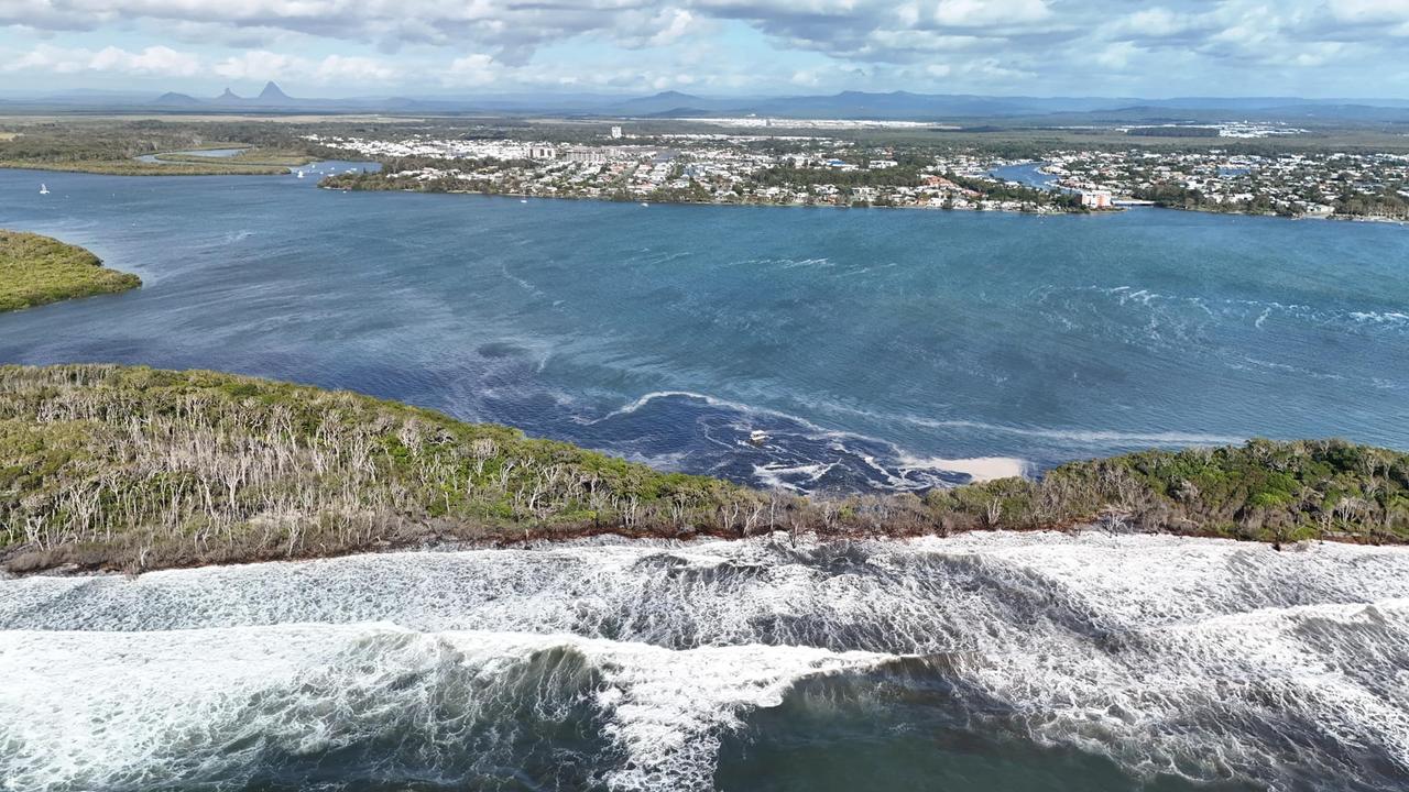
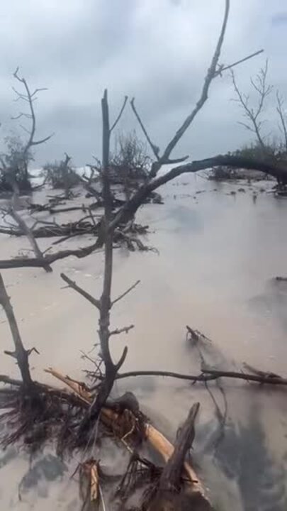
Mr Crisafulli said Queensland has experienced challenges with coastal erosion after reports of 15m swells off the coast of Wide Bay.

“We’ve seen some significant erosion in little parts of the Great Keppel Island, and people would have seen breakthrough on the north part of Bribie (Island) through the Pumicestone Passage into Caloundra, so that is an area that we’re definitely of concern and we’re certainly watching,” he said.
Opposition Leader Peter Dutton on Monday said he would be receiving a briefing on Cyclone Alfred and warned people from Bundaberg to Byron Bay they were in the firing line.
“It’s always hard because we don’t know exactly where this thing is going to track and hopefully it runs out of steam, but that doesn’t seem to be the indication at the moment,” he said.
“So I just say to people, listen to the advice that’s being offered by the authorities at the moment, and please act and prepare and make sure that you’ve got in place the plans that are necessary to deal with an event.”
Acting Commissioner Shane Chelepy urged people to start preparing now.
“Cyclones in south east Queensland are not typical but are not unprecedented, and for that reason we ask locals from K’gari area right through to the border, to understand your local risks,” Mr Chelepy said.
“Use this time to prepare yourself, prepare your homes.”
Mr Chelepy said they were working with local councils from Noosa to the Gold Coast to “deeply understand” the impact of storm surges.
“If you live in a low-lying area or foreshore, I ask you start preparing your home and consider the impacts this cyclone might have for you.”
Mr Chelepy expected barge and ferry services to stop running to island communities within the next 24-36 hours.
“I ask anyone who lives on the islands to consider your own risks.
“There will come a point where it’ll be too late to leave those islands.
“Our number one priority during an event like this is safety and preserving human life.”
Mr Chelepy said authorities were ensuring swift water rescue and SES crews were ready.
He said he had been in contact with the National Emergency Management Agency and the Australian Defence Force to co-ordinate planning ahead of the weather event.
Bureau of Meteorology senior forecaster Felim Hanniffy said a little upper trough moving across southeast Australia was helping drag Alfred southeast.
The warmer than usual waters south have also let Alfred maintain its status as a tropical cyclone.

Mr Crisafulli said he had spoken to the Brisbane Lions CEO ahead of the team’s season opener at The Gabba on Thursday.
“We will give them the information and Lion and the AFL will be able to make an informed decision … there’s plenty of time.”
LATEST WEATHER WARNINGS
Coastal hazard warning
Meanwhile events have begun to be cancelled across the state, with the Surf Life Saving Queensland Life Saving Championships one of the first.
The competition was to be held at Kirra on the Gold Coast from March 7 to 9, but SLSQ issued a statement on Monday saying the event had been cancelled in the interest of competitors and officials safety.
A coastal hazard warning was issued for people in parts of Wide Bay and Burnett and Southeast Coast forecast districts at 11.18am on Monday.
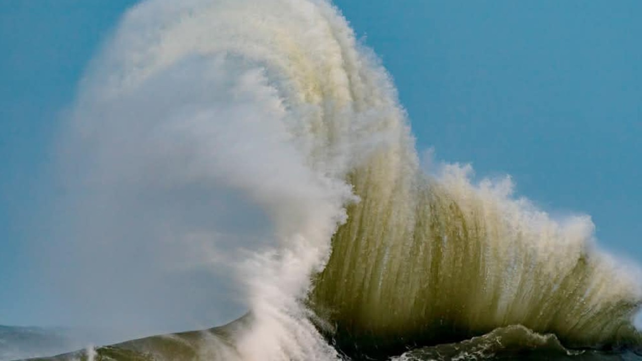
Cyclone Alfred is generating large and powerful east to north-easterly waves, with the waves combining with high tides to produce severe beach erosion for southern Queensland. Large waves are expected to persist for several days, however high tide peaks will start to recede slightly from today.
“Water levels on this morning’s high tide may exceed the highest tide of the year by less than half a metre and ease further into Tuesday but are expected to increase again during the week depending on the movement of Tropical Cyclone Alfred. This could lead to minor flooding of the foreshore and coastal erosion,” the warning read.
“Locations which may be affected include Gold Coast, Maroochydore, Coolangatta, Moreton Island, North Stradbroke Island, Noosa Heads, Rainbow Beach, and K’gari.”
Damaging surf conditions and significant beach erosion is likely between Sandy Cape and Coolangatta over the next several days.
Hazardous surf warnings remain in place for Capricornia, K’gari, Sunshine and Gold Coast waters.
Hazardous surf warning
The Bureau issued a hazardous surf warning at 4.21am on Monday for K’gari Coast, Sunshine Coast Waters and Gold Coast waters, with surf and swell conditions expected to be hazardous for coastal activities such as rock fishing, boating, and swimming.
People are advised to stay out of the water and avoid walking near surf-exposed areas.
Rock fishers are advised to avoid rock platforms that are exposed to the ocean.
Boaters are advised to reconsider their plans if they involve crossing shallow water and ocean bars, and those already on the water should carry the appropriate safety equipment and wear a lifejacket.
Flood watch
An initial flood watch has been issued for South East Queensland, with the prospect of widespread minor to major flooding with significant localised flooding possible later this week.
The warning, issued on Sunday afternoon, said heavy rainfall associated with Tropical Cyclone Alfred is likely from late on Wednesday, continuing on Thursday, Friday and into the weekend.
“High sea levels and large waves are likely at coastal locations, and may exacerbate flooding and cause flooding impacts,” the warning said.
“Minor to major flooding may develop across the flood watch area from late Wednesday into Thursday.
“The location of the most severe flooding will depend on the location of the heaviest rainfall, and the areas at risk will continue to be revised during the coming days.
“Rapid river levels rises and flash flooding is expected across many creeks, associated with the heaviest rainfall with widespread, including major, riverine flooding possible.”
Catchments likely to be affected include:
Mary River
Noosa River
Sunshine Coast Rivers and Creeks
Pine and Caboolture Rivers
Upper Brisbane River
Lower Brisbane River
Logan and Albert Rivers
Gold Coast Rivers and Creeks
Marine wind warning
Wind warnings for March 3
Gale Warning for the following areas:
Capricornia Coast, K’gari Coast, Sunshine Coast Waters and Gold Coast Waters
Strong Wind Warning for the following areas:
Hervey Bay and Moreton Bay
Wind Warnings for Tuesday 4 March
Strong Wind Warning for the following areas:
Capricornia Coast, Hervey Bay, K’gari Coast, Sunshine Coast Waters, Moreton Bay and Gold Coast Waters
Originally published as ‘Leave or stay’: Concern for islands, bay communities as Alfred homes in
Join the conversation

WATCH: Bandt spins out young voters with influencer Abbie Chatfield
Greens leader Adam Bandt has targeted young voters with a DJ set with influencer Abbie Chatfield dancing with a giant red toothbrush to plug a promise of ‘free dental’. SEE THE VIDEO
Read more
Ex-LNP head’s bizarre offshore wind farm claims
The former head of Queensland’s Liberal Party has called for voters to back LNP defector Gerard Rennick in a bizarre ‘how-to-vote’ card that makes false claims about the Labor Party.
Read more
Stolen car smashes into parked cars early on Anzac Day
A stolen car has rammed into two parked cars early on Anzac Day morning in an inner city Brisbane street with residents woken to loud bangs.
Read more

Anzac Day services cancelled after severe weather
Thousands braved the rain to attend Dawn Services across SEQ this morning, but some mid morning services and marches have been forced to cancel due to flooding. SEE WHERE
Read more

Council approval seals $11m development deal
A well-known developer bided their time and won approval for a 26-lot residential development on a large site that was once a family home before settling on an $11m purchase.
Read more

‘My car is gone’: MP rushed to hospital after crash
A Qld Labor MP has taken himself to hospital after his car was destroyed in a two-vehicle crash north of Brisbane last night.
Read more