
Queensland weather: Video shows snow in Stanthorpe
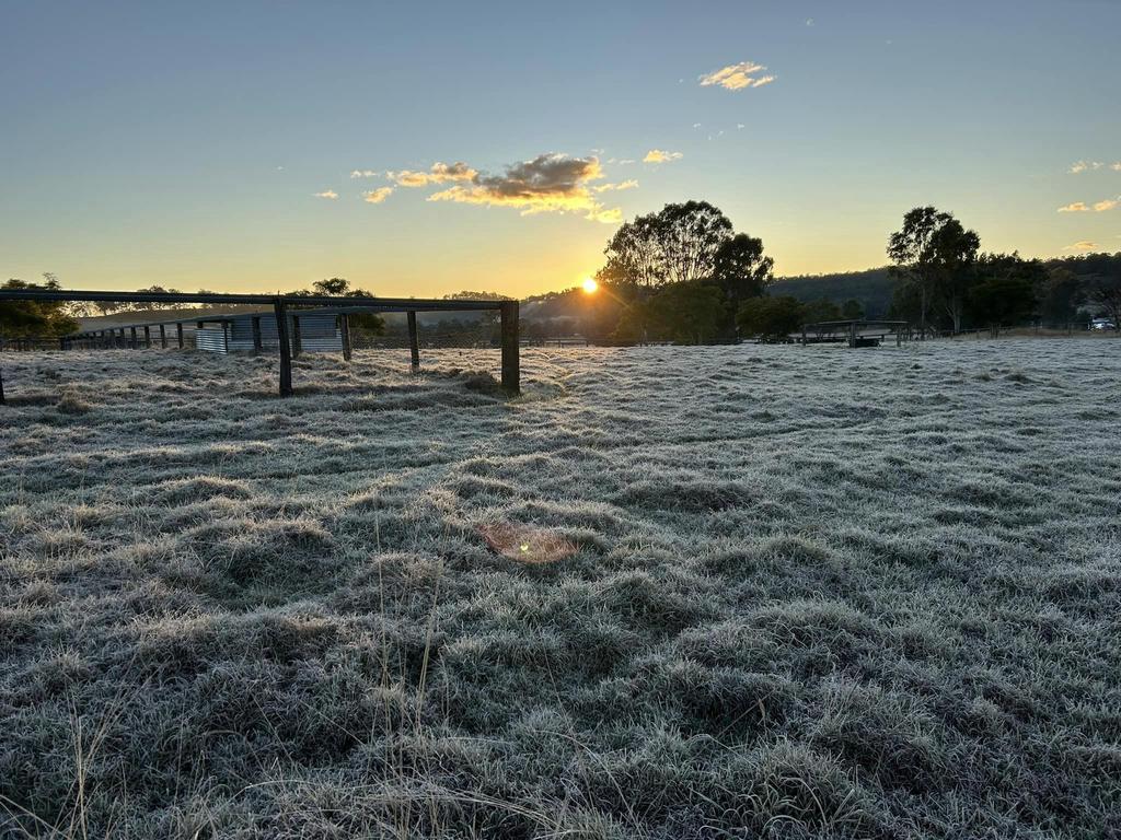
Snow appears to have fallen near Stanthorpe on Wednesday night as Queensland continues to shiver through a polar blast.
Snow appears to have fallen near Stanthorpe on Wednesday night as Queensland continues to shiver through a polar blast.
Footage captured by Stanthorpe Holiday Park shows a flurry of what appears to be snow falling in Stanthorpe along the New England Highway in Severnlea just before 7pm on Wednesday.
The video has since gained over 150 shares on Facebook with commenters asking if the snow made landfall.
“No just floating around! But my hands were like little ice blocks trying to catch it on video,” a Stanthorpe Holiday Park comment said.
Blake Dempster manager at the holiday park said it was cold out and an icy texture coated surrounding vehicles.
“It feels like rain, not sure if it’s snow or rain, it’s cold,” Blake Dempster manager at Stanthorpe Holiday Park said.
“Icy texture, it’s not white but has an icy texture. I’ve felt the trailer. Look I am not gonna get the bobsled out.”
Mr Dempster said people had been booking for the weekend in the hopes of catching a glimpse of the snow.
“There has been a bit of chatter around the park, towards the weekend people have booked but they are probably going to miss it,” he said.
The video was shared by the Granite Belt Wine Country Facebook page, which tagged the snow as a “special treat this Christmas in July”.
“A light dusting of snow here in Stanthorpe this evening in Queensland’s cool high country!”, the post read.
The nearby Granite Belt town of Applethorpe hit a high of 5.8C just after 2pm, and the mercury had plummeted to 4.5C at 7.20pm, with an apparent temperature of 0.7C.
There were also reports of snowflakes in Goondiwindi earlier this morning, when subzero temperatures spread as far north as Central Queensland.
Biloela, about 600km north of Brisbane, was 0.8C at 6.30am, but felt far colder with an apparent temperature of -2.9C.
The central west town of Blackall had plunged to -1.7C, but felt like -5.3C, making it the coldest place in Queensland this morning.
It comes after snow fell at Spicers Peak Lodge on Tuesday morning – the first time that had happened since 2015.
In the Wide Bay, Gayndah was -1.2C, but felt like -3.4C, while Kingaroy was 1.5C, but felt like -2.1C.
Across the Darling Downs and Granite Belt, Oakey dropped to -0.3C (felt like -4.5C), Applethorpe 2.4C (felt like -3.5C), Toowoomba 1.5C (felt like -5C) and Wellcamp -0.6C (felt like -6.4C).
In Freestone, near Warwick, a resident on social media said “it very much looks like sleet falling now”.
Bureau of Meteorology senior forecaster Angus Hines said there was still a chance isolated snow flurries could be seen in Queensland on Wednesday and wind gusts of up to 50km/h.
“There’s an outside shot again today in the far south from the very highest part of the Granite Belt,” he said.
“I don’t think anything accumulated on the ground yesterday, but a few flakes in the air and there’s the chance of that again today, this afternoon and maybe this evening and then those chances really subside Thursday.”
Temperatures were still too warm for snow to settle on the ground without heavy precipitation, as the westerly winds were making it feel up to 8C colder than the actual temperature.
Mr Hines said the southeast could see wind gusts about 50km/h on Wednesday with strong marine wind warnings in place before they ease into the afternoon.
“It’s likely to be pretty gusty again today across the southeast, maybe easing off a little bit through the second half of the day and then certainly into tomorrow,” he said.
“So pretty breezy over the land and pretty breezy over the water and a little bit a little bit calmer tomorrow.”
The forecaster said despite strong winds the sun would shine over the southeast on Wednesday but temperatures would be below average across the entire state in the high teens or low 20s.
“Most of the state looks to be below average across the day today, those maximum temperatures are on the cool side for pretty much the entire state,” he said.
“After Wednesday as that wind sort of dials back a little bit tomorrow, should again be a mostly sunny day across the southeast.”
Mr Hines said temperatures would “bounce up a little bit” from Thursday and continue to climb gradually in the following days with the forecast for Brisbane up to 20C on Thursday up from Wednesday’s 17C.
“A couple of showers remained possible around inland parts of the southeast, so up around the Darling Downs, Granite Belt but we shouldn’t see any of those hit the more populated coastal parts,” he said.
“Gold Coast, Sunshine Coast, Brisbane and then eventually all the way up the coast we’ve got some sunny weather for the rest of the week with temperatures just gradually climbing over the next few days.”
Nearly 20,000 power outages reported and a popular Brisbane riverside cafe forced to close due to structural damage after it wreaked havoc.

Originally published as Queensland weather: Video shows snow in Stanthorpe
Join the conversation

WATCH: Oprah Winfrey gatecrashes Brisbane birthday party
Read more

‘Surrounded by c***s’: Whinging pom’s foul-mouthed rant goes viral
Read more

Man allegedly assaulted staff, stole items before fleeing
Read more

Man stabbed in chest during wild suburban clash
A man has been rushed to hospital after he was stabbed at a north Brisbane home on Saturday night.
Read more

Four teens seriously injured after horror Logan rollover
Read more

Independent schools pull ahead in Moreton 2025 NAPLAN results
Read more