
Severe storms lash South East but worst is yet to come
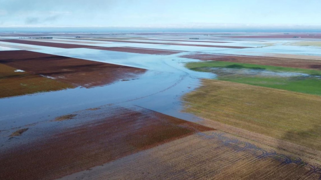
A man has died and there are fears for a second as a major flood emergency unfolds across southern Queensland. Brisbane residents are being warned to expect flooding in low-lying areas and Dalby residents have been told to move to higher ground, with another 200mm of rain possible over a 500km stretch of coastline.
QLD News
Don't miss out on the headlines from QLD News. Followed categories will be added to My News.
A man and a number of dogs have died, another man is missing, the Darling Downs town of Dalby is on emergency flood alert and Brisbane residents are being warned of potential flooding over coming days.
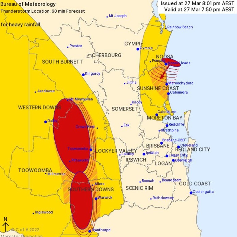
It comes after heavy overnight rain was added to throughout the day, with a 4.34pm severe weather warning from the Bureau of Metorology predicting heavy rainfall which may lead to flash flooding over areas southeast of Caboolture to Lowood to Warwick into the night and early Tuesday morning.
“Six-hourly rainfall totals between 80mm and 140mm are possible, reaching up to 180mm over coastal areas and ranges,” the warning said.
“Locally intense rainfall leading to dangerous and life-threatening flash flooding is possible with thunderstorms tonight with six-hourly rainfall totals in excess of 200mm.”
The upper and lower Brisbane River expected to be impacted by possible minor to moderate localised flooding. Other catchments on flood watch include Sunshine Coast rivers and creeks, the Pine and Caboolture rivers, Logan and Albert rivers and Gold Coast rivers and creeks.
The southeast has been lucky so far, with most of the intense falls remaining offshore but BOM senior forecaster Felin Hanniffi said the Gold Coast was in the firing line as of 7pm on Monday, with the coastal trough now lying just off Stradbroke Island.
“The trough could brush past the Gold Coast overnight, so that area holds the primary risk for heavier and localised flooding,” Mr Hannaffi said.
“It depends on if it drifts onshore or goes just off the coast, but there’s definitely a risk for people in the Gold Coast area.
“We’ve already seen totals since 9am today of above 100mm along parts of the Gold Coast and Stradbroke Island, which had near 130mm.
“Some of these areas could see another 100mm overnight so it wouldn’t be out of the question that some areas would see more than 200mm by 9am tomorrow.”
Dalby residents have been warned that rising flood waters could reach “major” levels and inundate the town, and have been advised to move to higher ground “immediately”.
Homes are under threat and campers and caravans forced to evacuate from rising flood waters that are set to split the town in two, its mayor has warned.
Western Downs Regional Council mayor Paul McVeigh said the Myall Creek, which runs through the town centre, was “still rising” and at 3.30pm had hit 3.1m.
An evacuation centre has been opened at the Dalby Events Centre for those located in low-lying areas of the town, and the council was also prepared to open Dalby South State School to those in need.
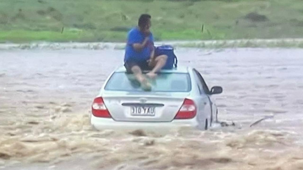
Two people were rescued on Monday night after they drove through flood waters near Toowoomba.
A swift water rescue team saved the pair who were found sitting on top of their car on Felton Clifton Rd, between Felton and Nobby, about 6.20pm.
It took emergency services about half an hour to rescue them, bringing them to dry ground just after 7pm.
Queensland Ambulance Services attended the scene but the pair did not require hospitalisation.
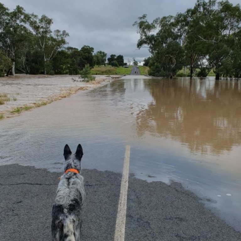
Another severely flood-hit area is facing evacuation orders, with North and South Lismore residents being urged to leave the high danger area as soon as possible with the saturated Wilsons River to rise to moderate and major flood levels.
It comes after the weather bureau warned the creek was expected to reach a major flood level of more than 3.5m by Monday afternoon or evening.
It comes after more than 160mm fell in parts of the Darling Downs and a severe weather warning for heavy rainfall up to 200mm and life-threatening flash flooding is issued for South East Queensland and NSW over a region of coastline stretching 500km.
Heavy rain is forecast to continue around the southeast on Monday and should gradually move south into New South Wales on Tuesday.
On Monday morning, a man was found dead after the vehicle in which he was a passenger was swept into floodwaters off Brimblecombe Rd at Kingsthorpe, west of Toowoomba, before 5am.
The female driver was rescued and taken to hospital in a stable condition, but the man and a number of dogs were found dead inside the vehicle about 8am.
Investigations are ongoing and police will prepare a report for the coroner.
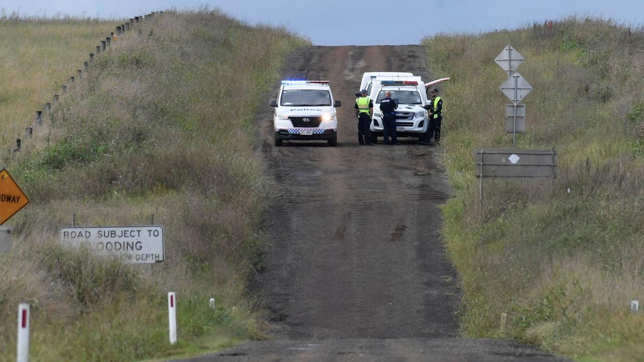
Meanwhile, a large-scale air and water search is under way to locate a man believed to be missing in floodwaters near Pittsworth, south of Toowoomba, since 6am.
Police say the man, understood to be aged in his 40s, was swept away after getting out of his vehicle at a Spring Creek crossing near Stirling Rd.
North Branch resident Graham Stirling held grave fears for the missing man.
“It’s (the rain) starting to abate now but I don’t think it will end up a good outcome,” Mr Stirling said.
“It was a big rain event last night, we had more than 100mm fall and further up in the hills near Pittsworth has also copped a bit and it’s flooded down.
“The helicopter came out and it’s done a search where the waters raged the most but doesn’t look like it found anything.”
A woman in a separate vehicle which was washed away from the same crossing was assisted to safety by members of the public.
Police, swift water rescue crews and a rescue helicopter have been tasked to help locate the missing man.
A spokesman said a swift water crew in a motorised craft searched upstream from the vehicle while a crew in an inflatable craft search downstream.
Several crews are also searching on land as the floodwater recedes. A rescue chopper was also tasked with the operation and is searching from the sky.
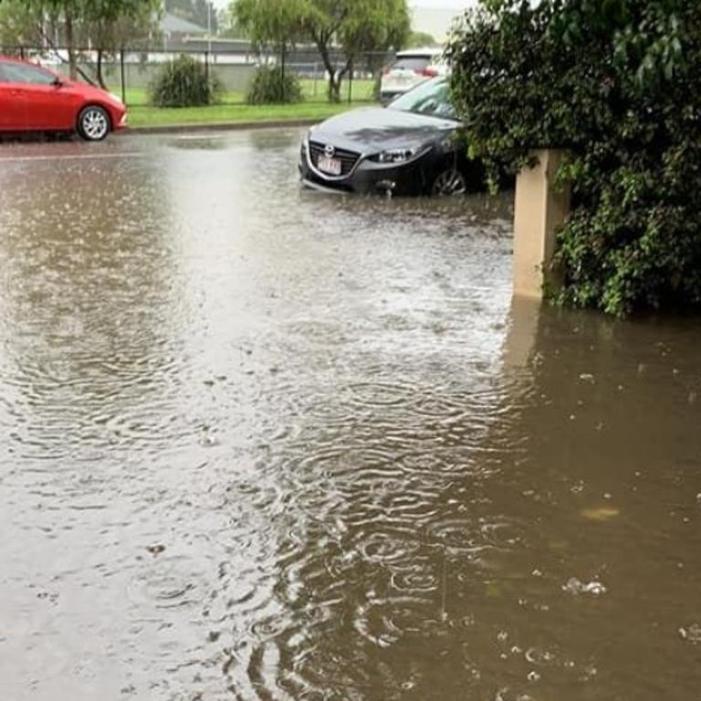
Brisbane Lord Mayor Adrian Schrinner has warned Brisbane residents that flooding could impact low-lying areas over the coming days, with flash flooding reported on Hale Street near Coronation Drive in Milton about 2pm on Monday.
Both the Wivenhoe and Somerset dams are releasing water into Brisbane River.
Cr Schrinner provided updates over a series of posts on Twitter.
“With the ground still saturated from Brisbane’s biggest rainfall event, the rain forecast over the coming days could lead to flooding in low-lying areas of our city,” Cr Schrinner wrote.
For up to emergency weather alerts, sign up to our early warning alert service via https://t.co/mm4E17Lcg5
— Adrian Schrinner (@bne_lordmayor) March 27, 2022
Cr Schrinner also reiterated that free sandbags are available at Brisbane City Council depots in Darra, Lota, Morningside, Newmarket and Zillmere.
Greens MP Micheal Berkman urged people whose cars are parked on Lang Pde in Auchenflower, especially around Dunmore Park, to move them as the water on the road is now knee deep.
It is also advised that anyone parked in other flood-prone areas in Brisbane move their vehicles.
The Bureau of Meteorology at 1.30pm updated its severe weather warning for the southeast coast, as well as parts of the Darling Downs and Granite Belt.
BOM warns that a coastal trough is expected to lead to heavy rainfall over South East Queensland from late today.
“Six-hourly rainfall totals between 80 to 140mm are possible, reaching up to 180mm over coastal areas and ranges,” a statement from the bureau said on Monday afternoon.
“Locally intense totals in excess of 200mm may occur with any thunderstorms.”
The bureau advised that because many catchments were now saturated, there was an increased risk of dangerous and life threatening flash flooding and even landslides during this event.
Dalby residents were warned that rising flood waters could inundate the town and potentially split the town in two.
The Western Downs Regional Council issued a warning to residents that the Myall Creek was predicted by the weather bureau to reach heights of 3.5m by Monday afternoon.
Cr McVeigh said the Charles Drew Bridge, which is part of the Warrego Highway, had been reduced to one lane and was likely to be closed by 5pm.
He said if the bridge closed as expected it would split the town in two.
Cr McVeigh said the Dalby Showgrounds had been set up as an emergency evacuation hub.
“We will have homes with water above the floor boards,” Cr McVeigh said.
“We had to evacuate the caravan park which is near the Myall Creek, about 30-odd vans, maybe more have come across.
“It’s a large enough capacity, they get beds, sheets, linen, and towels. We are ready to go.”
Cr McVeigh said the Dalby South State School could also be turned into a second evacuation hub if required.
“We are expecting the creek to get to 3.65m, major levels,” he said.
“The rain has been torrential. 80-160mm in the catchments.
“Hopefully it doesn’t get any worse but we are prepared.”
Residents in low-lying areas have been advised to collect and secure belongings or move them to higher ground.
The council asked residents to defer any non-urgent travel and stay out of flood waters.
Swift water crews have carried out five rescue missions across the Darling Downs region since about 4am on Monday.
The SES has also received 15 calls for assistance due to the extensive flooding.
Two motorists had to be rescued from the roofs of their cars while a motorist had to be rescued from the roof of their car which was swept off a road at Greenmount about 5am on Monday.
Swift water rescue crews reached the male driver, who was sitting on the roof of his vehicle, about 7.30am.
Multiple rescue crews also managed to save another driver who was trapped on top of their vehicle that was stuck in floodwaters off Mann Silo Rd at Kincora about 5.40am.
Another driver was reached by crews in an inflatable boat after their vehicle became trapped in floodwaters on Old Wyreema Rd at Drayton about 4am.
Western Downs Regional Council issued an emergency flood alert at 5.10am with the Myall Creek at Dalby is expected to reach exceed major flood levels on Tuesday night.
Floodwaters have closed a number of roads in the town
A total of 162mm was recorded southeast of Dalby at Jandowae since 9am Sunday, while just west at Bowenville 106mm fell.
Properties in low lying areas should warn neighbours, secure property and belongings, and prepare to move to higher ground. For further information please visit disaster.wdrc.qld.gov.au or listen to local radio.
The flooding has forced the closure of at least 11 schools, most of which are located west and south of Toowoomba.
Across South East Queensland, the highest falls were recorded at Pomona on the Sunshine Coast, with 121mm, and just south at Black Mountain with 106mm.
Parts of Brisbane recorded just over 30mm, with the heaviest falls coming just after midnight.
Residents in the southeast are bracing for the possibility of more dangerous flooding as a trough to move over Queensland is expected to dump huge totals on already-saturated areas.
The Bureau of Meteorology at 4.30am Monday issued a severe weather warning from Noosa to the Gold Coast and out to parts of the Darling Downs with the possibility of isolated falls of up to 200mm, leading to life-threatening flash flooding.
Meteorologist Helen Reid said that Brisbane could expect persistent rain over the next two days, with the highest falls expected today.
“Today, it’s looking probably to be the most wet shall we say in Brisbane,” Ms Reid said.
“I think by the time we get to tomorrow, I think most of the focus will have shifted further south.
“Not to say tomorrow’s going to be dry, but it won’t be quite as wet as what we’re expecting today to be.”
A hazardous surf warning has also been issued for parts of Queensland.
A developing low in the southern Coral Sea may lead to a significant easterly swell as high as 3.1 metres from Tuesday afternoon.
Coasts south of Cape Moreton are likely to be affected, while the Sunshine Coast isn’t expected to be impacted.
The Bureau warned that rock fishing, boating and swimming in Gold Coast waters is likely to be hazardous.
The rough conditions are expected to ease by Wednesday morning.

On Sunday, meteorologist Shane Kennedy said the focus of intense rain on Monday and Tuesday would depend on whether a coastal trough, currently over the ocean, will move over land and its location.
His primary concern was the impact of large totals falling on already-saturated ground and full dams, with the weather event expected to kick off on Monday morning.
“We could see some scattered rainfall in that 50mm to 100mm range but there is the potential for falls more in that 100mm to 200mm also,” Mr Kennedy said.
“So certainly flash flooding is a risk but we could also see some riverine rises as well …
“If we get that rainfall over a wide area that’s where we could really see those riverine rises.”
Mr Kennedy said there was still a possibility the trough could remain offshore, sparing the southeast from the worst of intense rainfall.
Coastal areas are expected to cop the heaviest rain.
The wet weather event is resulting from an upper trough moving over and enhancing the surface trough near the coast.
Mr Kennedy said the rain was expected to ramp up from Monday morning before the coastal trough moves away from the coast about Wednesday.
A separate set of storms created by thick humidity travelled through parts of the state’s southeast on Sunday night.
At 11pm a “near-stationary” line of heavy showers east of Dalby continued tracking southward through Pittsworth right down to west Warwick.
Oakey Pittsworth Rd and Mt Tyson Rd were closed between Toowoomba Cecil Plains Rd and Mount Tyson Rd due to heavy flooding created by the shower line as it travelled southwest from Mount Mowbullan to Warwick over several hours.
Multiple severe storm warnings were issued to people in parts of Southern Downs, Western Downs, Toowoomba, Lockyer Valley, Sunshine Coast and Noosa Council areas throughout Sunday night, with heavy rainfall subsiding in the northern Sunshine Coast about 9pm.
Initial severe storms affected parts of inland Queensland, with 79mm of rain falling between 4.30pm and 7.45pm at Jondaryan Lagoon and reports of 4cm hailstones in areas north of Alpha.
Meanwhile, 78mm of rainfall was recorded in two hours at Mount Mowbullan.
BOM senior meteorologist Grace Legge said Sunday’s storm activity had been created by a build-up of humid air mass over inland areas and the risk of localised flooding over the southeast would remain predominantly on Monday and Tuesday, should a separate upper trough deepen off the coast and make its way towards the coastal fringes.
“The current storms are starting to move further east, but we’re still expecting that constant rain and thunderstorms through Monday and Tuesday more than anything else,” Ms Legge said.
Ms Legge said the upper trough looming off the coast still had the potential to deepen over the next 48 hours but Sunday’s inland trough appeared to mostly impact areas across the state’s interior.
“The inland areas are getting between 50-80mm so far with these storms but it has definitely started to creep up in the last hour or so,” she said.
The BOM says a major flood peak of 3.65m is expected at Dalby on Monday night, with the ongoing rain causing rapid creek and river level rises along Myall Creek and Condamine River.
Issued just after 1pm, the Bureau said the major peak at Dalby overnight will be below the level recorded in 2011.
A minor flood warning remains current for the Bokhara River.
Catchments likely to be affected include, Sunshine Coast Rivers and Creeks, Pine and Caboolture Rivers, Upper and Lower Brisbane River, Logan and Albert Rivers, Gold Coast Rivers and Creeks, Condamine Rivers, Macintyre River, Weir River, Moonie River, Balonne River.
ROAD CLOSURES
More than 200 roads – mainly in the Toowoomba, Darling Downs and Warwick areas – have been affected by flash or long-term flooding, as a second flood emergency event unfolds in southern Queensland.
Some roads have remained closed from the first flood event, which rocked the southeast only a month ago.
The following roads have been closed to all traffic unless specified otherwise:
Brisbane Metropolitan and Ipswich:
Pitt Road, Wellington Point -entire road closed due to heavy rain
Hale Street, Petrie Terrace – left lane under Milton Rd, lanes reduced northbound towards Red Hill, delays expected
Lancing Street, Pullenvale -between Boyle Rd and Grandview Rd
Boscombe Road, Brookfield -between Brookfield Rd and Rafting Ground Rd
Gap Creek Road, Brookfield -at Gap Creek
Spring Street, Russell Island -entire road
Gold Coast, Logan and Scenic Rim:
Pacific Motorway, Elanora -in the vicinity of Exit 93 Off Ramp, all lanes affected
Northbound towards Tallebudgera, expect delays
Tallebudgera Creek Rd, Tallebudgera Valley -to end of road to Len Dickfos Rd
Hardys Road, Mudgeeraba -between Bonogin Road and Glenmore Drive
Mt Cougal Road, Tallebudgera Valley -between Tallebudgera Creek Road and end of road Kianga Court, Currumbin Valley -at intersection of Currumbin Creek Road
Currumbin Creek Road, Currumbin Valley -partial lane closures between Kianga Ct and end of Currumbin Creek Rd, with Kianga Crt also closed due to flooding
Old Coach Road, Reedy Creek / Tallebudgera Valley -between Kingsmore Blvd and Tallebudgera Creek Rd
Monarch Drive, Canungra -road closed due to heavy rain
Sunshine Coast, Moreton and Somerset:
Mount Oreilly Road, Samford Valley -road closed to all traffic both directions, long delays expected
Goat Track, Highvale -whole length of track due to flood damage
Kobble Creek Road, Kobble Creek -at Pringles Rd due to flood damage
Stringfellow Road, Caboolture -Morayfield Entrance to Rugby League Entrance
Riverview Street, Caboolture -at Bowls Club entrance to Centenary Lakes
Darling Downs, Toowoomba and Warwick:
Stanthorpe Inglewood Road,
Coolmunda, (Macintyre Brook Bridge), Macintyre Brook
Toowoomba Karara Road, Leyburn -approximately 1.5km south of Dalemere Rd, all lanes affected by heavy rain, proceed with caution
Gore Highway, Scrubby Mountain -in the vicinity of Heinemann Road, all lanes affected by heavy rain, proceed with caution
Oakey Cooyar Road, Highland Plains, In the vicinity of Griinkes Road
Bowenville Norwin Road, Wainui -approximately 3km for the Warrego Highway, all lanes affected by heavy rain, proceed with caution
Oakey Cooyar Road, Devon Park / Kelvinhaugh -road closed between Devon Park Boundary Road and Acland Sabine Road
Bowenville Norwin Road, Norwin, Intersection of Toowoomba Cecil Plains Road -reduced to local traffic only
Toowoomba Cecil Plains Road, Mount Irving,
Between Cockburn Road and Dalby Cecil Plains Road
Clifton Leyburn Road, Ellangowan -closed between Passmore Road and Toowoomba Karara Road
Toowoomba Cecil Plains Road, Norwin -closed between Peters Road and Bowenville Norwin Road
Toowoomba Cecil Plains Road, Nangwee / Norwin -closed between Brookstead Norwin Road and Nangwee Road
Brookstead Norwin Road, Norwin -in the vicinity of Toowoomba Cecil Plains
Leyburn Cunningham Road (Thanes Creek Bridge), Old Talgai -all lanes affected by heavy rain in the vicinity of Blink Bonne Road, proceed with caution
Macalister Bell Road, Jimbour East -closed between Dalby Jandowae Road and Jimbour Station Road
Ryeford Pratten Road (Kings Creek Bridge), Ryeford -between Clifton Leyburn Road and Harrigan Road
Bunya Highway, Bell, MacAlister -Bell Road Intersection
Leyburn Cunningham Road, Pratten -in the vicinity of Hazeldene Road
Leyburn Cunningham Road, Cunningham, -in the vicinity of Cunningham Road
Chinchilla Wondai Road, Jinghi / Pelican, -between Burra Burri Creek Road and Jandowae Connection Road
Oakey Cooyar Road, Highland Plains
Millmerran Cecil Plains Road, Kurrowah -at Crawlers Creek
Dalby Jandowae Road, Cooranga -at Hickeys Road Intersection
Jandowae Road, Dalby, Knight Street
Dalby Cecil Plains Road, Dalby / Saint Ruth -from Sandalwood Avenue East through to Duncans Road
Dalby Cooyar Road, Dalby -near Mount Pleasant Road
Jandowae Connection Road, Jandowae -just north of Winfields Road
Mt Tyson Road and Oakey Pittsworth Road, Motley / Mount Tyson -between Toowoomba Cecil Plains Road and Mount Tyson Road
Warrego Highway, Bowenville -water Over the Road between Jondaryan and Bowenville
Bunya Highway, Dalby -outside Dalby Hospital
New England Highway, Allora -in the vicinity of Reserve Road
Cunningham Road and Leyburn Cunningham Road, Cunningham / Montrose
Brymaroo Irvingdale Road, Brymaroo -water over road
Warrego Highway, Dalby -in the vicinity of Myall Creek
Darling Street, Drayton Wellcamp Road and Euston Road, Drayton / Glenvale / Wellcamp
Wellcamp Westbrook Road, Wellcamp / Westbrook, Cambooya Felton Road and Southbrook Road
Greenmount Etonvale Road, Greenmount
O’Mara Road, Wellcamp
Mary Street and Shannon Road, Clifton / Elphinstone
Stanley Street and Watts Siding Road, Cambooya / Greenmount, Watts Siding Road
Byers Road and Campbell Street, Oakey
Kelvinhaugh Yalangur Road, Kelvinhaugh
Kingsthorpe Silverleigh Road, Kelvinhaugh / Oakey
Bellview Road and Mount Molar Road, Mount Molar
Mann Silo Road, Brookstead
Clifton Pittsworth Road, Clifton Road and Volkers Road, Felton / Felton South / North Branch
Saint Helens Road, Saint Helens
Stoneleigh Road, Pittsworth / Stoneleigh
Knust Road and Main Street, Irongate / Mount Tyson
Jimna Springs Road, Southbrook
Yarramalong Road, Tummaville -due to river flooding
Oleary Road, Ellangowan / Old Talgai
Jondaryan Mount Tyson Road and Main Street, Mount Tyson
Leslie Bridge Road, North Branch / Tummaville
Bostock Road, Lemontree / Millmerran -due to river flooding
Tummaville Road, Kincora / Tummaville -due to river flooding
Grantham Winwill Road and State Route 80, Winwill -water over the road
Winwill Connection Road, Lower Tenthill / Winwill -water over the road
Gomoran Douglas Road, Douglas / Muniganeen, Traffic Hazard -water over the road
Peranga Narko Road, Narko, Traffic Hazard -water over the road
Jondaryan Mount Tyson Road, Jondaryan, Traffic Hazard-water over the road
Jondaryan Evanslea Road, Jondaryan, Traffic Hazard -water over the road
Kearney Road, Oakey, Traffic Hazard -water over the road
Blanchview Road, Blanchview / Silver Ridge -water over the road
Flagstone Creek Road, Silver Ridge / Upper Flagstone -water over the road
Emu Creek Hall Road, Pierces Creek Road, Pierces Road, Emu Creek / Pierces Creek, Traffic Hazard -water over the road
Cockburn Road, Jondaryan, Traffic Hazard -water over the road
Flagstone Creek Road, Flagstone Creek-water over the road
Turner Street, Helidon, Water Over Road – Road Closed
Gore Highway, Kincora -just east of the Brookstead Township
Pittsworth Felton Road, Felton -in the vicinity of Hodgson Creek
Drayton Street and Myall Street, Dalby -due to river flooding
Millmerran Leyburn Road, Tummaville -in the vicinity of Kirby’s Crossing over Canal Creek
Warrego Highway, Jondaryan, Eastern side of Doctors Creek, between Jondaryan Mount Tyson Road and McKenzie Road
Chubb Street and Myall Street, Dalby -due to river flooding
Patrick Street, Dalby -due to river flooding
Branch Creek Road, Dalby
Condamine Street, Coxen Street and Jimbour Street, Dalby -due to river flooding
Inverai Road, Tuckerang -closed due to water over the road
Bowenville Norwin Road, Wainui -in the vicinity of Oakey Creek
Myall Street, Dalby -water over the road
Dixon Street, Dalby, Clarke Road, Clarke Road and New England Highway, Spring Creek -burst water main
Talgai West Road, Talgai
Upper Spring Creek Road, Forest Springs
Merivale Street, Allora
Junabee Road, Junabee
Dawn Lane
Condamine River Road, Killarney / The Head
Glenolive Road, Condamine
Roche Creek Road and Windeyer Road, Wandoan
Grosmont Road, Grosmont
Booral Road, Grosmont
Yeovil Road, Grosmont
Paradise Road, Drillham South, due to flooding which is now higher than 1 metre
Harphams Road, Condamine, due to flooding which is now higher than four metres
Ehlma Boundary Road, Brigalow -closed due to water over road
Mount Sylvia Road and Mt Sylvia Road, Junction View / Woodbine
Barcaldine and Central West:
Eyre Developmental Road, Bedourie / Birdsville,
Bedourie – Birdsville via Cuttaburra Crossing
Diamantina River Road, Middleton, -from Old Cork Waterhole to Diamantina National Park (to Diamantina council boundary)
Wokingham Stock Route, Corfield -between Corfield Richmond Rd and Landsborough Hwy
Inside Track Road (Birdsville Inside Track), Birdsville -Birdsville to SA Border
Cacoory Stony Crossing Road, Birdsville -from Eyre Developmental Rd to junction with Birdsville Developmental Road
Betoota Mooraberree Road, Farrars Creek -Mooraberree Station to Diamantina Dev Road (Mooraberree Station to Diamantina council boundary)
Mount Playfair Road and Mt Playfair Road, Caldervale/ Carnarvon Park / Tambo -Tambo to Carnarvon Park
Langlo Road, Langlo /MacFarlane -Tambo to Langlo (Tambo to Murweh Council Boundary)
Ward Road, Tambo /Ward -Tambo to Ward (Tambo to Murweh Council boundary)
Originally published as Severe storms lash South East but worst is yet to come

CHO’s legacy at stake as new study explodes vaping myth
The progress made by former chief health officer Jeannette Young in cutting smoking rates in Queensland is at stake as a new study exposes an inconvenient truth about vaping. VOTE IN OUR POLL
Read more

Verdicts ‘unreasonable’: $90m Qld coke smugglers appeal convictions
The drug smugglers behind an international conspiracy to bring $90m worth of cocaine into Queensland claimed the jury got it wrong.
Read more

US nuclear submarine bobs up in Queensland
A nuclear-powered submarine has joined the USS Frank Cable in Brisbane. Find out why and see our exclusive first look inside the sub repair ship.
Read more

Queensland’s new ‘boot camps’ to tackle youth crime
Several new boot camp-style programs to target the youth crime crisis gripping Queensland will open up across the state, drawing comparisons to former premier Campbell Newman’s “expensive failure”.
Read more

‘Befriended rock stars, royalty and criminals’: Touching farewell for Beatty
A who’s who of Queensland television turned out to farewell their charismatic mate Michael Beatty at a celebration of life event on Sunday.
Read more

Major changes proposed to boost Queensland organ donation rates
Organ donation could become easier in Queensland under changes, including the consent process, proposed by the state government.
Read more