
North on cyclone watch as rain lashes south
Heavy rain is lashing parts of Queensland’s south after a cyclone watch was declared for the far north’s coast.
QLD News
Don't miss out on the headlines from QLD News. Followed categories will be added to My News.
The state’s far north remains on cyclone watch after a severe thunderstorm warning was cancelled for further south.
The Bureau of Meteorology cancelled the severe weather warning which was issued for southeast Queensland earlier this afternoon.
A severe thunderstorm was heading eastward from Southern Downs and towards Scenic Rim before the Bureau assessed it was no longer threatening.
Heavy rainfall is still expected, Warwick, for example, recorded 50mm in 40 minutes to 3:35pm.
The situation will continue to be monitored and further warnings will be issued if necessary.
Earlier today, a cyclone watch was declared for the Far North coast between Cape Flattery and Lucinda as a low pressure system off the coast continues to develop.
Meteorologists from the Bureau of Meteorology (BOM) said the system was about 270km east of Cairns about 10am Sunday and was expected to be upgraded to a cyclone Tuesday morning.
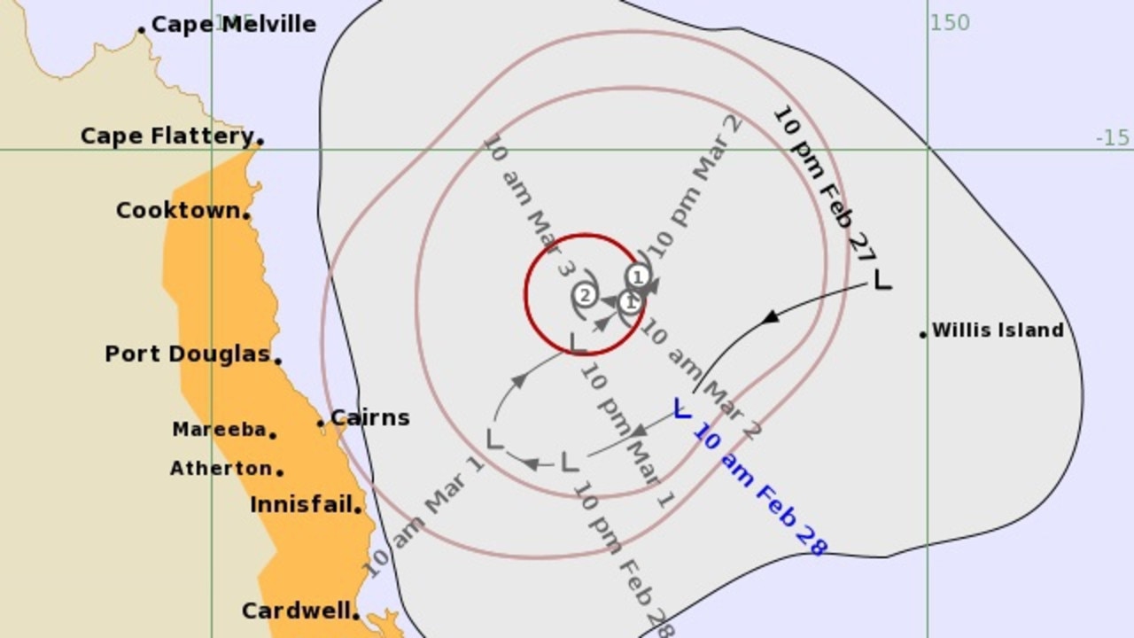
Forecast tracking predicts it could reach Category 2 by Wednesday.
“Although a direct coastal impact is not expected, gales are possible about exposed coastal and island areas as the system reaches cyclone strength. Heavy rainfall is also likely,” the forecast said.
“People between Cape Flattery and Lucinda, including Port Douglas, Cairns, and Innisfail, should consider what action they will need to take if the cyclone threat increases.”
Meteorologist Michael Gray said conditions were “favourable” for intensification of the Low into a tropical cyclone early next week.
“The next tropical cyclone to form in the Australia region will be called Niran,” he said.
“At this stage there is some uncertainty in the timing and position of development and subsequent movement of the system.
“Current guidance suggests that the system may linger off the northeast coast for a couple of days before moving to the southeast, remaining over water throughout the forecast period.”
Mr Gray said showers and thunderstorms were increasing over the tropical north and central coast over coming days due to the development of the monsoon trough and a reach of high pressure along the east coast.
“The focus for rainfall about the tropical north east will be highly dependent on the development and position of the tropical low or cyclone,” he said.
It was earlier predicted the risk of showers and thunderstorms will extend to inland parts of the southeast coast district on Monday and even greater on Tuesday.
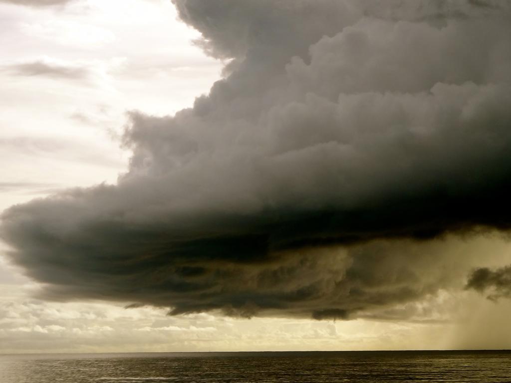
Heavy rainfall could develop on the coast and inland over the next few days and a flood watch is currently in place between Mission Beach and Townsville.
Gales of up to 100km/h could develop as the system intensifies.
Abnormally high tides are also predicted.
The system is currently moving southwest at 15km/h.
The cyclone update comes as severe thunderstorms are possible today in parts of the northeast coast and mid northern Queensland.
BOM issued a forecast for possible severe storms with heavy rainfall and damaging wind gusts from Julia Creek to Georgetown and Cooktown.
Severe storms are also forecast as possible on the coast between Townsville and Proserpine.
General storms are also possible about much of inland Queensland and parts of the Darling Downs and Granite Belt, however these storms are unlikely to be severe.
EARLIER
The Bureau of Meteorology is monitoring a developing low off the north tropical coast, which is likely to develop into a cyclone early to mid this week.
The low in the Coral Sea, just offshore of Cooktown, is expected to form into tropical cyclone Mirin late Tuesday afternoon.
BOM meteorologist Michael Gray said the low was causing significant rainfall over a large area between Mackay and Cairns, which is set to last until at least midweek.
“Since 9am yesterday, we’ve seen rainfall totals up around 100mm around the Proserpine River and over 50mm through large parts of an area from about Mackay up towards Cairns,” he said on Sunday.
“We’ll still see fairly significant rainfall from about Mackay to Cairns throughout today, that’ll continue for the next couple of days with that low in the area through at least to Tuesday, Wednesday, possibly through to later in the week as well.”
An update on the development of the low is expected later today.
Meanwhile in southeast Queensland, average temperatures have returned after a brief but powerful heatwave made its way through parts of the state last week.
Mr Gray said partly cloudy conditions with a low chance of rainfall were forecast across much of the southeast today and tomorrow.
Brisbane is set to be partly cloudy with a top of 31C today and 32C tomorrow.
“A very slight chance of showers, so a 20-30 per cent chance over the next couple of days,” he said.
“We will see generally similar conditions through the next couple of days, so fairly cloudy, light winds generally … fairly unlikely to see any storms.”

Originally published as North on cyclone watch as rain lashes south

The Sunday Quiz: Who became South Africa’s president in 1994?
Who sculpted the statue of David? Earth is in which galaxy? What gives plants their green colour? Put your knowledge of trivia to the test with The Sunday Quiz.

Be fearless and enter the Sunday Mail Transurban Bridge to Brisbane
More than 50 people of all abilities will tackle The Sunday Mail Transurban Bridge to Brisbane for team FEARLSS Coaching. HOW TO REGISTER

I shouldn’t even be in the NRL. Now the fate of Qld is in my hands
Gehamat Shibasaki will make a shock debut for Queensland in the State of Origin decider on Wednesday night and the Maroons bolter has exclusively revealed his driving force.

Rugby desperately needs a shot in the arm, this is what could save it
Daniel Herbert believes rugby union can launch a spectacular bid to win over the floating sports fan, but it could also be the key to pulling the flailing code out of the red. THIS IS HIGH STEAKS.

‘We take on risk, saving owners stress’: House flipping with a difference
The shock of being made redundant while on maternity leave was brutal for Kate Mahoney – but rather than wallow in self-pity, she got busy with a hammer and paintbrush.

AFP investigate Qld links in massive 2.5 tonne cocaine seizure
The AFP have confirmed it is investigating Queensland links to a massive 2.5 tonnes of cocaine seizure off New Caledonia that would have been Australia’s largest ever seizure.