
Powercor helicopters to map Geelong, Surf Coast streets
The Avalon Airshow may have ended weeks ago but low flying aircraft will continue to buzz above Geelong skies.

News
Don't miss out on the headlines from News. Followed categories will be added to My News.
If you thought the skies above the Geelong region would quieten down following the Avalon Airshow, you’d better think again.
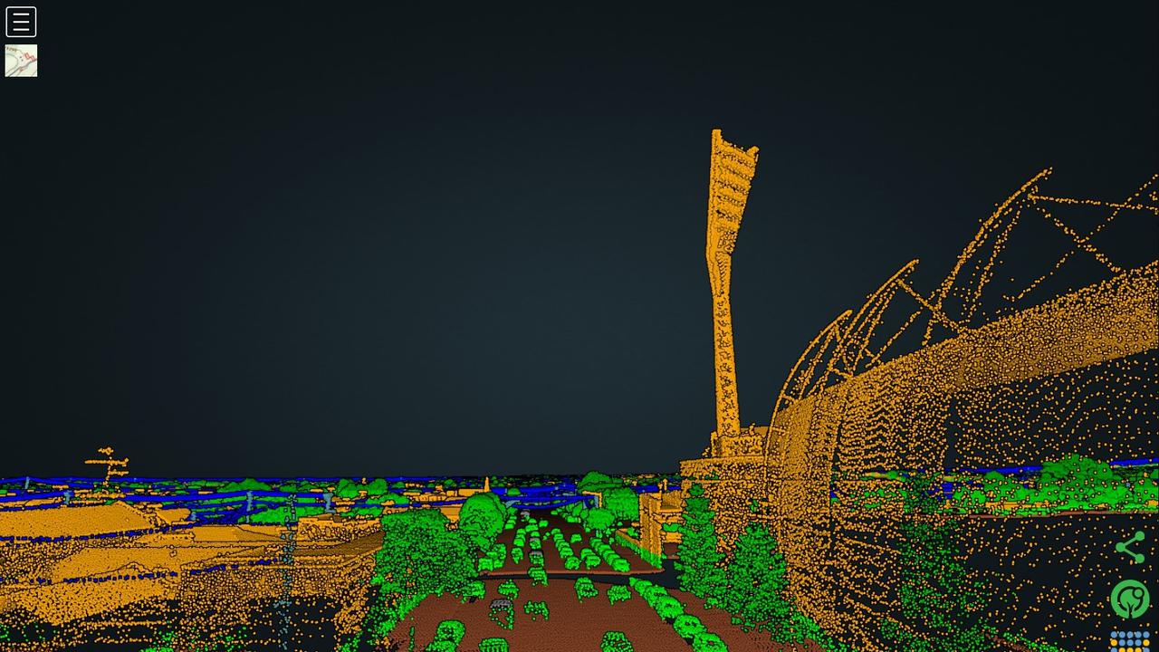
Low-flying laser-equipped helicopters will swoop over streets across Geelong, the Bellarine, and the Surf Coast as part of an aerial operation by a major electricity provider.
Powercor will use its fleet of choppers to carry out it’s vegetation management program, which will be conducted from mid-April until early May.
The purpose of the exercise is to identify trees along the powerline network that need to be trimmed before they can cause power outages or fires.

Flying as low as 300 metres at more than 125km/h, the aircraft will use scanning technology known as Light Detection and Ranging (LiDAR) to create 3D models of the environment.
Head of vegetation management Ayce Cordy said the mapping exercise was incredibly useful to the organisation.
“Inspecting and managing vegetation growing near powerlines is an essential part of how we keep power safe and reliable for our customers,” he said.
“By capturing data every year, we can track growth rates of vegetation across our network, helping us plan where to cut right now and when we may need to conduct cutting in the future.”
Between them, the helicopters will collect three terabytes of data a day.
Powercor has more than 85,000 kilometres of powerlines spanning the state — 77,000 of which lie in the western half — that delivers electricity to 1.75 million Victorians.
The businesses cutting teams need to meet clearance requirements regulated by Energy Safe Victoria.
Originally published as Powercor helicopters to map Geelong, Surf Coast streets

Charlemont ‘spooky house’ finally demolished
Following significant delays, a demolition crew has begun tearing down the Charlemont ‘spooky house’, in a welcome sign for neighbouring residents.

55+ pics: Geelong baseball heats up with incredible tie
There was a stunning eight-all draw in Geelong junior baseball on Saturday morning. See all the photos from a great match.

Roos robbed? How controversial umpiring calls unfolded in VFL thriller
A free kick and 50 metre penalty handed Geelong victory against North Melbourne after the siren. The player at the centre of both decisions sheds light on the contentious finish. Watch the video here.

Newman, Catman ignite finals turf war
Geelong legends Sam Newman and Catman go claw to claw over whether the Cats deserve a home final. Decide who won turf war.

Man critical after alleged Great Ocean Road hit-and-run
A man has been rushed to Geelong hospital in a critical condition after he was found unresponsive in a car that was allegedly involved in a hit-and-run.

Selwood’s emotional TV return after brother’s death
Geelong great Joel Selwood has thanked the public for the support as he spoke of his family’s heartache after the shock death of his brother Adam.