
Flood watch cleared in southern NT after Tropical Cyclone Ilsa devastates WA
A flood watch has been cleared in Central Australia as ex-Tropical Cyclone Ilsa tracks towards the Top End. See pictures of the devastation left in its wake.
Northern Territory
Don't miss out on the headlines from Northern Territory. Followed categories will be added to My News.
A flood watch has been cleared in Central Australia as ex-Tropical Cyclone Ilsa weakens and moves towards the Top End.
Bureau of Meteorology senior meteorologist Rebecca Patrick said Ilsa had weakened below tropical cyclone strength in Western Australia on Friday evening.
“It did move into the NT early on Saturday,” she said.
“We saw some heavy falls around that Western Australia border area.
“The low that was Ilsa travelled eastwards, it did weaken off to a trough around the middle of the day (on Saturday), and continued to weaken as it travelled east.”
Ms Patrick said the trough was now “rapidly rocketing northwards”.
“We’re now seeing blue skies across southern parts of the NT, with a southerly flow pushing through,” she said.
“The trough is moving through the Top End (Sunday), so we will see more showers and storms across the Top End.”
Ms Patrick said much cooler conditions would be experienced across the southern Northern Territory in the next few days, with temperatures about eight to 10 degrees below average on Sunday and Monday.
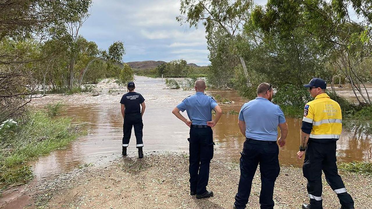
The Bureau of Meteorology at 9.52am Sunday said flooding was no longer expected for parts of the Inland Northern Territory.
It said no significant rainfall was forecast over the flood watch area for the next few days.
“Flooding in low lying areas and river and creek rises are expected to continue easing across the flood watch area,” the Bureau said.
“However, rainfall over the last few days and areas of flooding may adversely affect some of the unsealed roads.
“Check road conditions before travelling.”
It comes as wet and rainy conditions caused the cancellation of events in Alice Springs on Saturday night, with light festival Parrtjima closed on its second last night.
A flood warning was previously in place in Central Desert, Western Desert, MacDonnel Ranges, Finke River and Stephenson Creek, Simpson Desert, Georgina River and Eyre Creek.
Tropical Cyclone Isla to flood southern parts of Northern Territory
Central Australia is on alert for potential flooding as ex-Tropical Cyclone Ilsa travels across the northern Lasseter district.
The record-breaking system is bringing a “rain band with embedded thunderstorms” to southern parts of the NT.
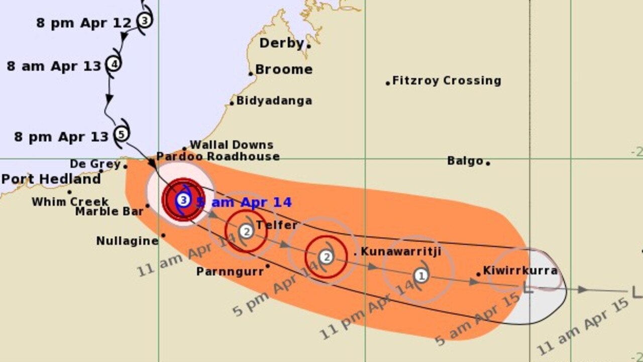
The Bureau of Meteorology at 11.34am Saturday said the ex-cyclone would continue east and would weaken throughout the day.
They said it would approach Alice Springs on Saturday afternoon.
“Rainfall totals of 10-40 mm is expected over the flood watch area, with possible heavier falls to 80mm during the remainder of Saturday,” the Bureau said.
Bureau forecaster Sally Cutter said the northern parts of the Lasseter and southern parts of the Tanami region was expected to see the most rainfall, as well as Alice Springs and northwest parts of the Simpson district.
“We could see falls up to 100mm or even a little bit higher,” she said.
“Most of them will be a little bit lower – in that 50mm-80mm mark.
“But those really intense rainfalls are going to fall over a space of a few hours.”
Aflood watch is current for a number of NT catchments: Central Desert, Western Desert, MacDonnell Ranges, Finke River, Stephenson Creek, Simpson Desert, Georgina River, and Eyre Creek.
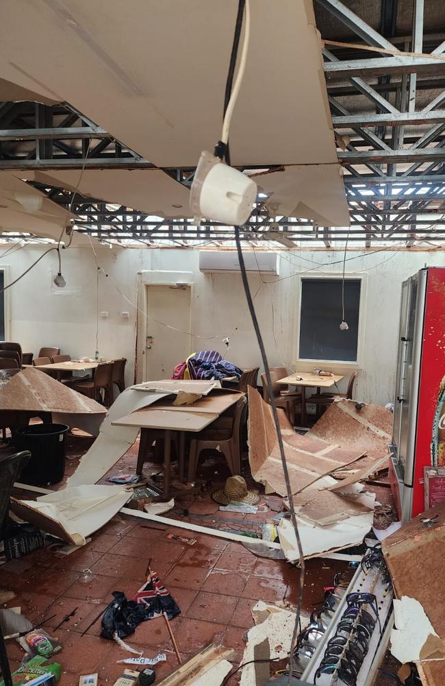
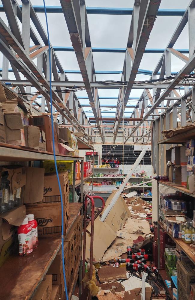
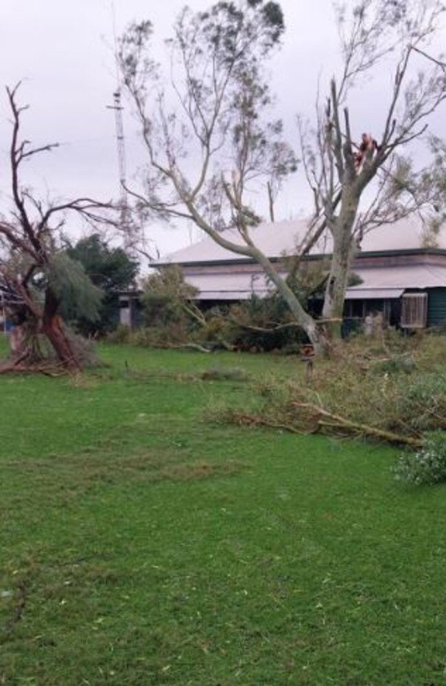
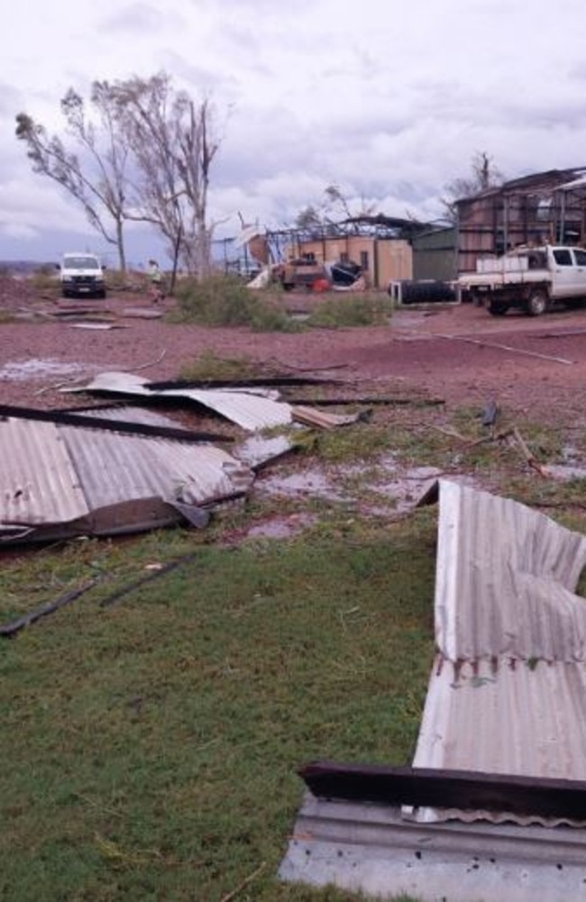
Ex-Tropical Cyclone Ilsa previously reached category five when it made landfall on Western Australia’s Pilbara coast on Thursday night.
Wind speeds reached as high as 288km/h on Thursday night and early Friday morning.
The Pardoo Roadhouse and Tavern, a combination service station and eatery on the Great Northern Hwy, experienced the full brunt of Ilsa’s arrival, and was at one stage in the eye of the storm.
Friday: Tropical Cyclone Ilsa: Flash floods, damaging winds to hit NT
The record-breaking Tropical Cyclone Isla is barrelling closer to the Territory.
The cyclone made landfall on WA’s Pilbara coast Thursday night as a category five system, which was downgraded to a category two by Friday afternoon.
The Bureau of Meteorology’s Sally Cutter said it was expected to cross as a tropical low into the southern parts of the Northern Territory in the early hours of Saturday.
“As it moves through the southern parts of the Territory we’re going to see heavy rainfall particularly near and just to the south of the path of the low, plus also the potential for damaging wind gusts and isolated falls,” she said on Friday afternoon.
Ms Cutter said the northern parts of the Lasseter and southern parts of the Tanami region was expected to see the most rainfall, as well as Alice Springs and northwest parts of the Simpson district.
“We could see falls up to 100mm or even a little bit higher,” she said.
“Most of them will be a little bit lower – in that 50mm-80mm mark.
“But those really intense rainfalls are going to fall over a space of a few hours.
“There could be some flash flooding through the through the area, particularly the northern parts of the Lasseter district into the northwest parts of the Simpson district.”
Ms Cutter said Alice Springs could expect most of its rain in the early afternoon of Saturday, before the system clears “very quickly” that evening with dry south-easterly winds.
Tropical Cyclone Ilsa was previously thought to have no impact on the Territory as it moved parallel to the Kimberley coast.
However Bureau of Meteorology senior forecaster Billy Lynch said the system was expected to U-turn to the NT, bringing rainfall to Central Australia.
FRIDAY 9.15AM
Mr Lynch said the cyclone – which set a new record for sustained wind speeds – would downgrade to a tropical low by the time it reached the NT border about 5am Saturday.
“That low will move across southern NT during Saturday,” he said.
Flood watches are currently in place for the regions expected to be hit hardest by the “destructive” system’s soggy path.
“The heaviest falls are expected across the Western Desert catchment during Friday evening and Saturday morning,” the Bureau said.
“Heavy falls are possible along the MacDonnell Ranges and the Central Desert during Saturday.”
Mr Lynch expected warnings for heavy rainfall and damaging wind gusts to be issued later on Friday.
#CycloneIlsa will weaken into a deep low on Saturday, moving through southern #NT and bringing strong winds, heavy rainfall and flooding, which may cause roads to become impassible. Keep up to date with the warnings at https://t.co/pVXOPQqlmd & @secureTerritory#AliceSpringspic.twitter.com/jIp8E6BZrK
— Bureau of Meteorology, Northern Territory (@BOM_NT) April 12, 2023
The Bureau predicted 30-60mm of widespread rainfall in the area for late Friday and Saturday.
“Totals of greater than 100mm possible near the path of the low,” they said.
“Rainfall may cause significant water level rises in rivers and creeks and prolonged overland flooding and pounding from late Friday and roads may become impassable.
“Some communities and homesteads may become isolated.”
The catchments likely to be affected include the Central Desert, Western Desert, MacDonnell Ranges, Finke River, Stephenson Creek, and Warburton District Rivers.
More Coverage


Originally published as Flood watch cleared in southern NT after Tropical Cyclone Ilsa devastates WA
Join the conversation

Bail on the cards for Darwin Show stabbing attack accused
An assessment is underway to determine whether the 15-year-old boy accused of stabbing another teenager at the Royal Darwin Show is suitable to go home.
Read more

90 year-old victim of alleged robbery by three teens
A 90 year-old Katherine man is the latest victim of an alleged robbery by teens.
Read more

Watchdog warns against youth crime crackdown, CLP ‘unapologetic’
NT Children's Commissioner warns rushed youth crime reforms could harm children and worsen community safety as government fast tracks plan to reintroduce spit hoods and tougher sentences.
Read more

Palestinian flag scored across jetty, memorials defaced in Nightcliff
The overnight act at Nightcliff and other areas of Darwin has been labelled as carried out in ‘poor taste’ and a ‘waste of taxpayers’ money’.
Read more

Man dies after truck and SUV collide on Stuart Hwy
A young man has died in a fatal head on collision between an SUV and a truck on the Stuart Highway. Read the details.
Read more

Matt Wright enters not guilty pleas ahead of chopper conspiracy trial
The trial of Territory reality television star Matt Wright is set to begin after the Outback Wrangler entered his not guilty pleas. Read what is expected during the four-week trial here.
Read more