
Darwin, Top End monsoon likely to result in flooding, with 24 catchments impacted by heavy rainfall
Flooding is likely to become more widespread over the Top End, with residents already cut off and communities at risk as rivers continue to rise. Read what’s in store for the next few days.
News
Don't miss out on the headlines from News. Followed categories will be added to My News.
Flooding is likely to become more widespread over the Top End, with residents already cut off and communities at risk as rivers continue to rise.
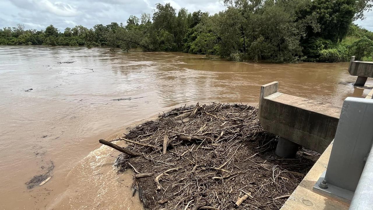
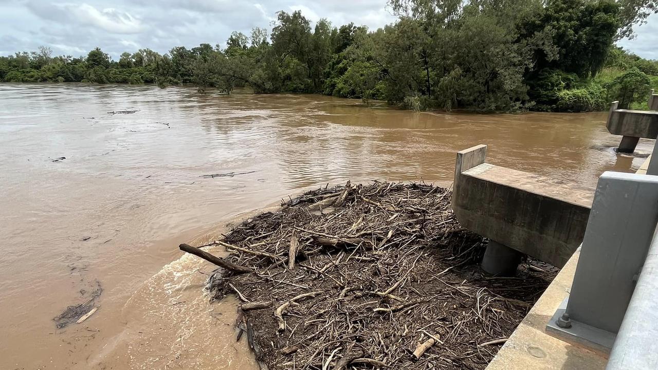
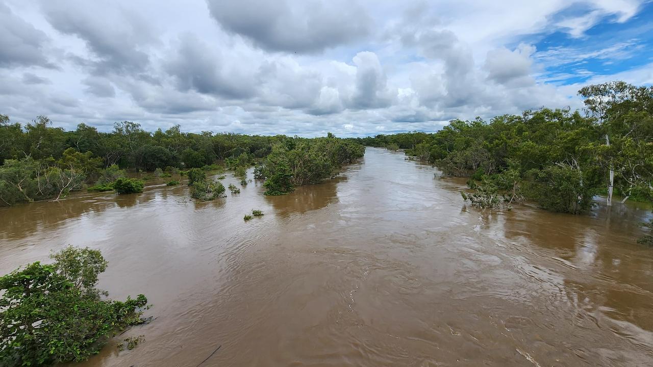
The Bureau of Meteorology has issued a flood watch for parts of the Top End and Bonaparte Rivers, with 24 river catchments impacted by rising waters.
The weather monitoring agency said an active monsoon trough was producing scattered heavy showers and thunderstorms across the Top End, causing rivers to swell.
“Rainfall may cause river levels to rise and trigger possible flooding in rivers and creeks,” the Bureau said.
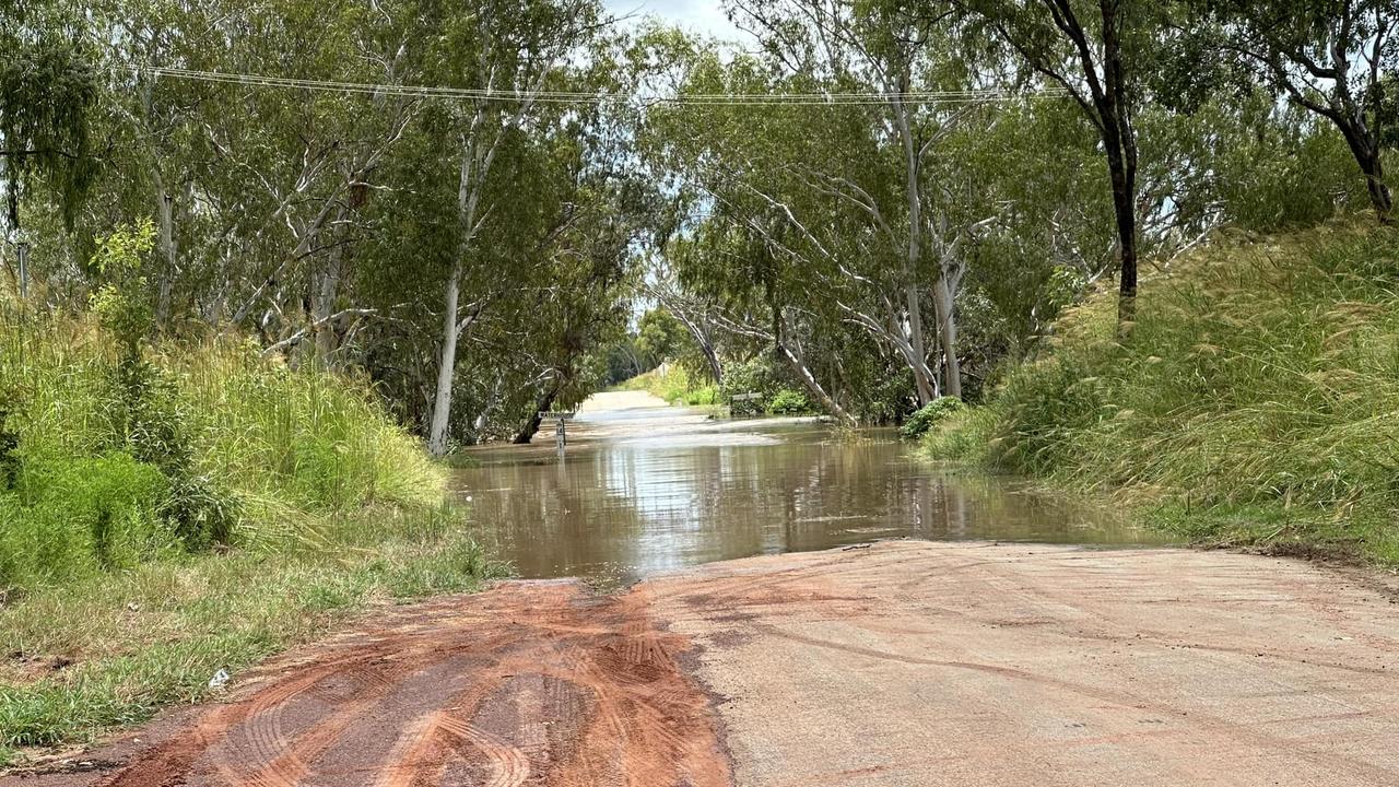
“This may also prolong or renew local flooding and ponding. Roads may become impassable.
Some communities and homesteads may become isolated.”
As of Sunday a moderate flood warning was active for the Daly River, while a minor flood warning is current for the Waterhouse River.
The Bureau said in the past 24-hours to Sunday, the monsoonal conditions had dumped up to 100mm of water across the north of the Territory, with isolated totals up to 130mm in the Daly and Victoria catchments.
And the rain is unlikely to cease, the Bureau said, with widespread totals of 40-70mm predicted over the next few days.
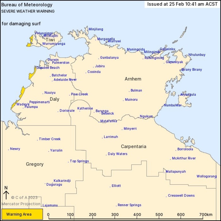
âš ï¸SEVERE WEATHER WARNING for DAMAGING WINDSâš ï¸
— Bureau of Meteorology, Northern Territory (@BOM_NT) February 25, 2023
The monsoon is strengthening. Damaging wind gusts to 100 km/h are possible with monsoonal showers from Sunday morning in the Daly District and Tiwi Islands #NT. See latest warnings at https://t.co/ZoWyLpbrr8pic.twitter.com/d65RW0OV8g
The Bureau said 24 river catchments were impacted by the heavy rainfall: Upper Victoria River, Victoria River below Kalkarindji, Fitzmaurice River, Mary River, Upper Adelaide River, Adelaide River below Adelaide River Town, Finniss River, Lower Daly River, Daly River above Douglas River, Katherine River, Moyle River, South Alligator River, Wildman River, Buckingham River, Goyder River, Blyth River, Liverpool River, Goomadeer River, East Alligator River, Koolatong River, Walker River, Waterhouse River, Roper River, and East Kimberley Rivers.
The Northern Territory Emergency Service has deployed volunteers to the Daly River community to assist with the ongoing flood response efforts on Sunday afternoon.
The Bureau warned that rising river levels could result in moderate flooding along the Daly River, with the police station most at threat over the next two days.
It said widespread rainfall totals up to 39mm were recorded across the Daly River catchment in the past 24 hours, with the days of consistent rain resulting in rivers and creeks rising.
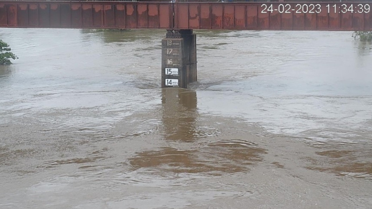
The height of the river has reached 11m at the Daly River Police Station, and was expected to exceed the minor flood level of 12.6m on Sunday.
“The river level may reach the moderate flood level — 13.1m — during Monday. Higher levels are possible with continued heavy rainfall over the next few days,” the Bureau said.
On Sunday afternoon the Bureau reported that the Daly River height had reached 19m at Dorisvale Crossing, and was still rising.
Water levels were also rising at Beeboom Crossing and Daly River Police Station, but were falling at Mount Nancar.
Minor flooding was also predicted along the Waterhouse River, as the river surges over Beswick Bridge cutting off hundreds of residents.
The Bureau said the river level exceeded the Beswick Bridge on Thursday morning and is expected to remain above the bridge level during Sunday and into Monday.
It said while the river has since fallen below minor flood levels of 7.7m, the risk of further river rises remains active.
“Higher levels and renewed minor flooding are possible overnight Sunday into Monday with further heavy rainfall,” it said.
Secure NT reported on Sunday that the Victoria Highway was impassable at Mathison Creek bridge due to flooding.
It comes as the flooding risk has eased along the Katherine River at Nitmiluk centre, but river levels remain high around the Katherine township.
Katherine residents are not currently at threat of minor flooding, the Bureau reported on Sunday afternoon, with water levels expected to remain below the 16m flood mark.
“Further small river level rises are possible over the next few days along the Katherine River at Katherine Bridge, but the river level is likely to remain below the minor flood level,” the Bureau said.
The Bureau said minor flooding was not expected at Katherine River Gorge Road, however water levels would be closely monitored under the ongoing Top End flood watch.
FINAL FLOOD WARNING for KATHERINE RIVER
— Bureau of Meteorology, Northern Territory (@BOM_NT) February 26, 2023
Flooding has eased along the Katherine River at Nitmiluk Centre. No further flooding is expected at Gorge Road. The Katherine Bridge is likely to remain below the minor flood level. For details see https://t.co/Whq1LyvDEE#NTfloodspic.twitter.com/mJRix4Udwc
“River levels remain elevated along the Katherine River and its tributaries but are generally easing,” it said.
“Showers and thunderstorms are forecast to continue over the next few days which is likely to keep river levels elevated.”
The Bureau has also issued a two-day marine wind warning for Beagle Bonaparte Coast, North Tiwi Coast and Arafura Coast, with strong winds also expected for Van Diemen Gulf by Monday.
The Northern Territory Emergency Service has reminded residents to take precautions during the flooding, to stay away from flooded drains, rivers, streams and waterways.
For emergency help in floods, storms and cyclones call 132 500.
Monsoonal rain, windy weather to persist in Darwin, Top End over weekend
SAT, FEB 25: Monsoonal rain, windy weather to persist in Darwin, Top End over weekend
Blustery showers and cool temperatures hitting Darwin are likely to build up over the rest of the weekend.
The Bureau of Meteorology’s Billy Lynch said monsoonal conditions were expected to increase over Saturday night and into Sunday
“Darwin this weekend can expect a cool, cloudy wet weekend due to strengthening monsoonal weather,” he said.
“It’s all being driven by a weak tropical low which is over the northeast Kimberley.

“We’re expecting that low to strengthen a little overnight and tomorrow, with conditions expected to get windier.”
Mr Lynch said the tropical low had a very low risk of developing into a cyclone.
“We’re also expecting some increased waves and swell across the coast,” he said.
“There’s a marine wind warning in place at the moment with strong wind developing tomorrow.”
A severe weather warning for damaging surf has also been issued, which could lead to localised damage and coastal erosion in the Daly and Tiwi districts from Sunday morning.
Some of the heaviest rainfalls across the Top End in the 24 hours to 9am Saturday include 96mm at Howard Springs and 93mm at Leanyer.
It comes as minor flooding occurs in the Katherine and Waterhouse catchments, while moderate flooding is forecast for the Daly River police station on Monday.
The Katherine River beside the town was at 12.5m on Saturday morning and falling.
Mr Lynch said a flood watch was current for the entire Top End.
“In terms of forecast rainfall we’re expecting 20-50mm with isolated falls up to 100mm across the Top End,” he said.
“The heaviest rainfall is probably going to be over the Daly district where we could see falls of 120mm.
“All the river systems are responding quite quickly.
“We’re urging everyone to be safe out there.
“Don’t drive into flooded streams and rivers, and check road conditions before you go out.”
Friday
A monsoonal flow sweeping over Darwin is expected to strengthen on Friday and into the weekend.
It comes as the Katherine River swells to 14m, threatening to spill over into the regional town, while flood watches remain for several parts of the Top End.
The Bureau of Meteorology’s Sally Cutter said the wet conditions could persist into next week.
“It’s going to stick around at least through the weekend,” she said on ABC Radio on Friday.
“There’s a little bit of variation between the models further out but it might hang around into next week.
“We’re going to have a low down in the south west corner of the Top End, or just over the border, and that’s going to keep this monsoonal flow (coming).”
Minor flooding was continuing at Nitmuluk Centre on Friday morning after the river reached a peak of 4.65m the day prior.
Katherine residents were being urged to prepare for flooding with less than 2.5m between the current level and the minor flood level.
However forecasts suggest the river is likely to remain below that flooding threshold over the weekend.
Ms Cutter said flood watches and warnings were also in place around the Daly River and Waterhouse River region.
“At this stage this we’re looking at minor flooding,” she said.
“Because the ground is so saturated any rain that does fall will run off.
“So even if rivers don’t break their banks the river will rise.”
Across the Top End some of the heaviest 24-hour rainfalls to 9am Friday included 114mm at Noonamah, 154mm at Port Keats and 124mm at Cave Creek Station.
Up to 50mm was expected in Darwin over Friday, with 60mm possible on Saturday.
The Katherine mayor Elisabeth Clark has recently called for the Territory government to fast-track its plans to build a second high-level bridge to mitigate the impacts of flooding.
The government has earmarked construction to take place in the next 10 to 15 years.
The current bridge, which is more than 20m high, is the only road access into Katherine from the north open year-round and to all vehicles.
More Coverage


Originally published as Darwin, Top End monsoon likely to result in flooding, with 24 catchments impacted by heavy rainfall
Join the conversation

‘Not an idle threat’: One in 5 NT childcare centres could shut under new laws
One in five Territory childcare centres not ‘up to scratch’ could be shut down under new laws passed by federal parliament. SEE THE FULL LIST.
Read more

From despair to racetrack glory: How jockey got back on the saddle
A journeyman jockey can complete one of racing’s biggest redemption stories as he continues to transform his life from party boy to a career driven jockey who has overcome alcohol addiction.
Read more

Voice leaders accused PM of using Garma as ‘performative opportunity’
Labor has been accused of using the nation’s biggest festival of Indigenous culture to spruik talking points, rather than address hardships facing Aboriginal people.
Read more

Positive meningococcal case recorded at Territory school
A student who tested positive for meningococcal at an Alice Springs school is recovering, with the NT Centre for Disease Control revealing the number of confirmed cases this year.
Read more

Legal body condemns Minister’s ‘bizarre’ attack on NT Coroner
Australia's peak judicial body has slammed NT Minister Robyn Cahill's ‘extraordinary’ attack on the Territory Coroner, warning it had no place in public debate.
Read more

Top cyclist: ‘I got shafted sideways with depression and anxiety’
What should have been the happiest day of his life - being selected in an Australian cycling team - saw this brave father-of-three suffer depression and anxiety. But now he’s preparing to don the green and gold.
Read more