
Tropical cyclone watch: Alerts issued for Gulf communities
Severe weather warnings and flood warnings for rivers are in place as ex-Tropical Cyclone Lincoln moves west, with the Bureau predicting the system could reform to cyclonic intensity.
Cairns
Don't miss out on the headlines from Cairns. Followed categories will be added to My News.
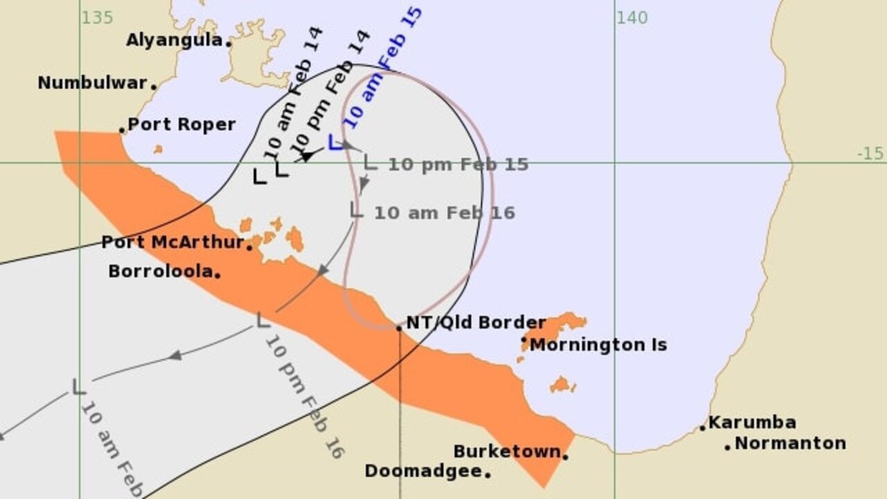
Ex-Tropical Cyclone Lincoln is moving west across the Northern Territory, with the Bureau of Meteorology predicting it could redevelop off the Kimberley coast mid-next week.
Ex-Tropical Cyclone Lincoln weakened below tropical cyclone intensity inland of the Northern Territory coast near Borroloola last night.
Ex- Cyclone Lincoln is expected to move west across the central NT throughout the weekend and then over the Kimberley in Western Australia early next week, bringing heavy rainfall to areas near its path.
It is forecast to reach waters west of the Kimberley and north of the Pilbara by the middle of next week, and there is a moderate risk it could redevelop into a tropical cyclone.
If it does redevelop far enough offshore there is potential to strengthen to a severe tropical cyclone, according to the Bureau.
Tropical #CycloneLincoln's exposed low-level circulation making landfall along the NT's Carpentaria coastline. pic.twitter.com/JymG1dwiY2
— Andrew Miskelly (@andrewmiskelly) February 16, 2024
Centre Island, just off the coast near Borroloola, received 202mm rainfall.
A severe weather warning is currently active for parts of Carpentaria, Barkly, Gregory, and Tanami districts.
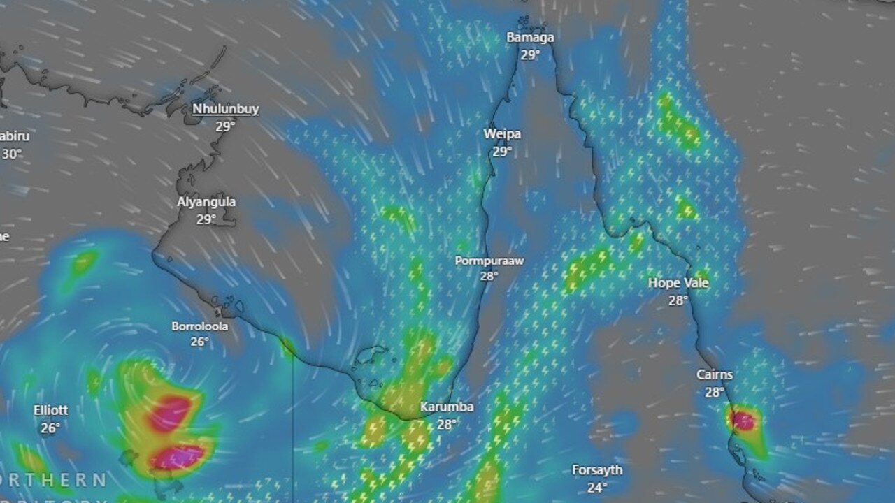
Wind gusts of 100km/h and heavy rain have swamped already sodden parts of the southern Gulf of Carpentaria Coast as Tropical Cyclone Lincoln made landfall with residents now on flood watch as rivers rise in the gulf country.
The low category system made landfall around 4.30pm on Friday afternoon as a category one system between Port Arthur and the Northern Territory-Queensland border.
While the cyclone did cross the coast in a sparsely populated area of the coast, more populated areas around Burketown are now on high alert as heavy rain falls across the catchment.
In the last 24 hours 134mm of rainfall was recorded at the Burketown Airport but heavier falls have been recorded across more isolated and remote parts of the catchment.
The Bureau have renewed a major flood warning for the Nicholson River with major flooding possible at the Burketown Airstrip from Saturday with predicted rainfall.
Along the Nicholson River, moderate flooding is likely to be occurring at Escott Station. Minor flooding is occurring along the Gregory River at Gregory Downs.
Burke Shire Mayor Ernie Camp said there were still fears for properties in the region as rain continues to fall up river.
“We have little bits of sunshine here now but there are still fears for property as we play the waiting game for how much water comes down the system,” Mayor Camp said.
“The cyclone crossed the coast in a lot of remote areas but we have seen isolated rain gauges with 48 hour rain totals of 678mm.”
“We expect a lot of rainfall down the lower parts of the Nicholson and Gregory River catchments.”
⛈ TC Lincoln has moved on, but the rain could linger a little longer 💦
— Qld Fire & Emergency (@QldFES) February 17, 2024
The cyclone we had our eyes on weakened to a tropical low overnight and is expected to move in a westward direction across the Northern Territory. However, continued heavy rainfall is likely to occur… pic.twitter.com/4GHuoA9R8F
Mr Camp called for a greater number of rain gauges so that communities can better plan for when river rises occur upstream.
“We need more river gauges especially on the Nicholson, we already had high levels in these systems and better monitoring will give us a clearer understanding about what was coming down river,” he said.
Mr camp said about 50 Burketown residents and those who lived on remote cattle stations had been evacuated to places like Mt Isa prior to the event.
“No we just play a bit of a waiting game and keep an eye on what is coming down the river.
EARLIER
Packing wind gusts of 100km/h Tropical Cyclone Lincoln formed in the southern Gulf of Carpentaria at midday on Friday.
Cyclone Lincoln is expected to cross the coast near the Queensland border with the Northern Territory late Friday afternoon as a category one system.
Bing Bong in the NT, to Burketown including Borroloola, Port McArthur and Mornington Island have all been identified as areas within the warning zone, as the slow moving system tracks south from The Gulf.

Cyclone Lincoln brought strong winds and heavy rainfall to the southern Gulf of Carpentaria coast within a largely unpopulated area of the remote coastline.
Cyclone Lincoln is forecast to move to the southwest and make landfall between the NT and Queensland border and Port McArthur, according to the Bureau of Meteorology.
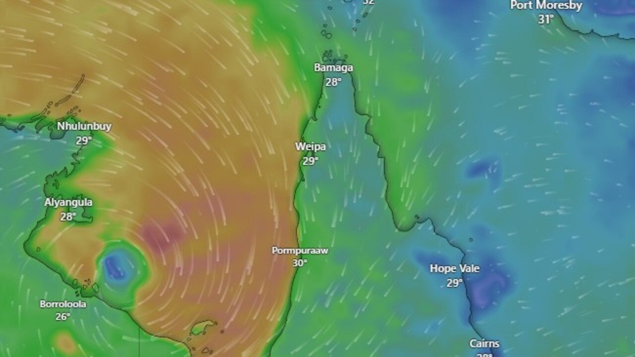
Darwin-based Bureau community information officer Patch Clapp said parts of The Gulf of Carpentaria coast are likely to experience gale force winds and heavy rainfall.
Severe Weather Update: Category 1 Tropical Cyclone Lincoln to cross the NT coast. Video current: 1pm ACST 16 February 2024. For the latest forecasts and warnings go to our website: https://t.co/4W35o8iFmhpic.twitter.com/DaeodInRHZ
— Bureau of Meteorology, Australia (@BOM_au) February 16, 2024
“The warning zone has now contracted to the west of Mornington Island,” he said.
“We expect to see pretty windy conditions and locally intense rainfall including Burketown and a little further afield as well.”
Meanwhile, Mr Clapp said a weather convergence is expected to dump heavy rain on the Cassowary Coast as far south as Ingham throughout the weekend.
While totals of 90mm were expected for the Cassowary Coast, around Cairns more moderate rainfall estimates predicted up to 50mm on Saturday with a high chance of showers continuing into Sunday.
Cairns locals have also been advised to prepare for king tides from Monday February 19 through to Monday February 26.
The tide event will peak at 3.09m on Thursday morning.
Cairns Regional Council advised moving cars from low-lying tidal areas in Portsmith and Cairns North.
“Motorists should drive carefully and slowly, not only for the safety of road users and pedestrians, but to lessen the impact of bow waves, which can push water into nearby properties,” a spokesman said.
Council may close roads which are inundated by tidal flooding to prevent damage to private property.
EARLIER
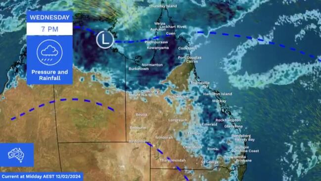
On Thursday a tropical cyclone ‘watch now’ alert was issued for communities in Queensland’s Gulf Country, the Bureau of Meteorology has warned with areas west of Burketown in the firing line.
The watch now was issued for the southern Gulf coast west of Burketown on Wednesday night.
Tropical Low 07U is currently sitting in the western Gulf and has a 40 per cent chance of developing into a Tropical Cyclone by Friday.
The watch zone extends from Port Roper in the Northern Territory across the southern gulf of Carpentaria coast to Burketown including Mornington Island.
As of 10am Thursday the tropical low had sustained winds near the centre of 55 kilometres per hour with gusts reaching 85 kilometres per hour and was slowly moving south and expected to cross the coast east of Port McArthur in the Northern Territory.
The Bureau’s Shenagh Gamble said the low was currently situated in The Gulf of Carpentaria, but that it would likely head back towards land in the coming days.
“The tropical low is located south of Groote Island and north east of Borroloola,” she said.
“At the moment it’s got around 55 km/h winds sustained with 85 km/h gusts and the system is in a fairly favourable environment.
“During today (Thursday) we expect it to be fairly slow moving, taking a bit of an easterly track before slowly heading south over Friday and Friday evening and southwest towards the Northern Territory border.
“[On] Wednesday, we issued a cyclone watch for communities between Port Roper and around to the Northern Territory/Queensland border. This morning, we’ve upgraded that now to a cyclone warning because we do expect the impacts of that system to be felt within the next 24 hours.”
Ms Gamble said the low being in The Gulf meant it had the potential to grow exponentially.
“In the past 24 hours we have seen this low potentially develop into a cyclone at a moderate level,” she said.
“We are still looking at a 40 to 45 per cent chance of this becoming a tropical cyclone, however we do take precautions when the system is in The Gulf of Carpentaria, because those conditions there are really favourable for system development.
“If this system does develop, it could develop quite quickly and it could develop into a stronger cyclone, even potentially develop into a category 2.”
Even if it doesn’t form, the Bureau of Meteorology has warned of major flood warnings with the risk of heavy rain and strong winds as the tropical low crosses.
“Localised falls could reach up to 200mm especially around the southern gulf coast from Normanton westwards, and these are areas that are already in flood,” Bureau of Meteorology senior meteorologist Felim Hanniffey said.
“Thunderstorm activity will see isolated falls much higher than the 100-150mm predicted across the south gulf coast and the western peninsular will also be experiencing some heavy falls and strong gusty winds,” Mr Hanniffey said.
With the overarching monsoonal trough controlling the weather for the rest of the week rainfall is expected across most of the Far North particularly across the cape and along the east coast.
“Monsoon trough above Cairns will bring showers along the coast with some localised moderate falls with the risk of heavier falls easing further into the weekend.”
Cairns could see rainfall totals as high as 30mm through Friday with temperatures remaining steady with tops of 31 degrees into the weekend.
Along the Coast Innisfail will see a slightly higher chance of heavier rain with totals of up 35mm predicted both Friday and Saturday, and the Cooktown will see similar falls with tops of 32 degrees.
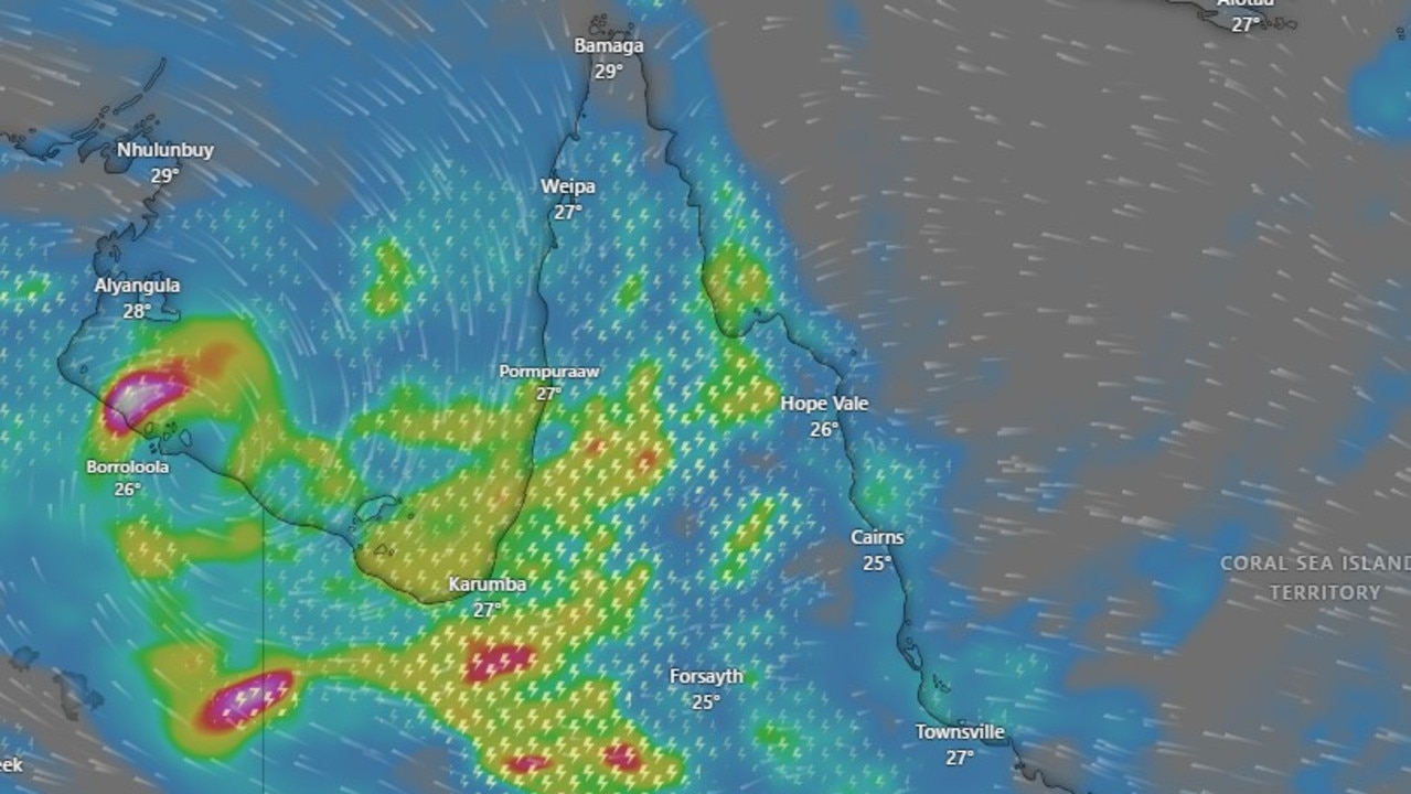
A major flood warning remains in place for the Flinders River with water easing slowly at Walkers Bend.
There is also a moderate flood warning for the Nicholson River and Minor flood warnings for the Norman and Gilbert Rivers.
Flooding in Gulf towns such as Normanton and Burketown may worsen over the coming days.
More Coverage


Originally published as Tropical cyclone watch: Alerts issued for Gulf communities
Join the conversation

Hwy reopened, three hospitalised following multi-vehicle crash
The Kennedy Highway has been reopened to traffic following multi-vehicle crash, which left three people hospitalised, on Thursday afternoon.
Read more

‘Hectic wildfire season’: Deliberately lit bushfires
A Far North Queensland-based firefighter has warned many homes are not prepared for fire-season as crews contain fires claimed to be deliberately lit.
Read more

FNQ’s collection of on-road oddities and troppo transport options
From a kid towing a boat behind an e-scooter to a go-kart on the main drag of a Tablelands town, the Far North has no shortage of on-road oddities when you just have to get there. See the hilarious list.
Read more

YOUR SAY: Qld’s election promises unpacked
Queenslanders have been promised a lot in recent months ahead of October’s state election – but what can we trust and what is simply a vote-grab? HAVE YOUR SAY
Read more

Police seize rifles and handguns in firearm blitz
A police crackdown on illegal firearms including raids on properties throughout Far North Queensland has resulted in the seizure of 18 unlicensed or unregistered weapons. Watch the video.
Read more

Masked gang’s violent home invasion in southern Cairns
Police are seeking witnesses after a masked gang broke into a home in Bentley Park, targeting residents and damaging property. Find out more here.
Read more