
Monsoon off Tully shifts severe weather warning south: BOM
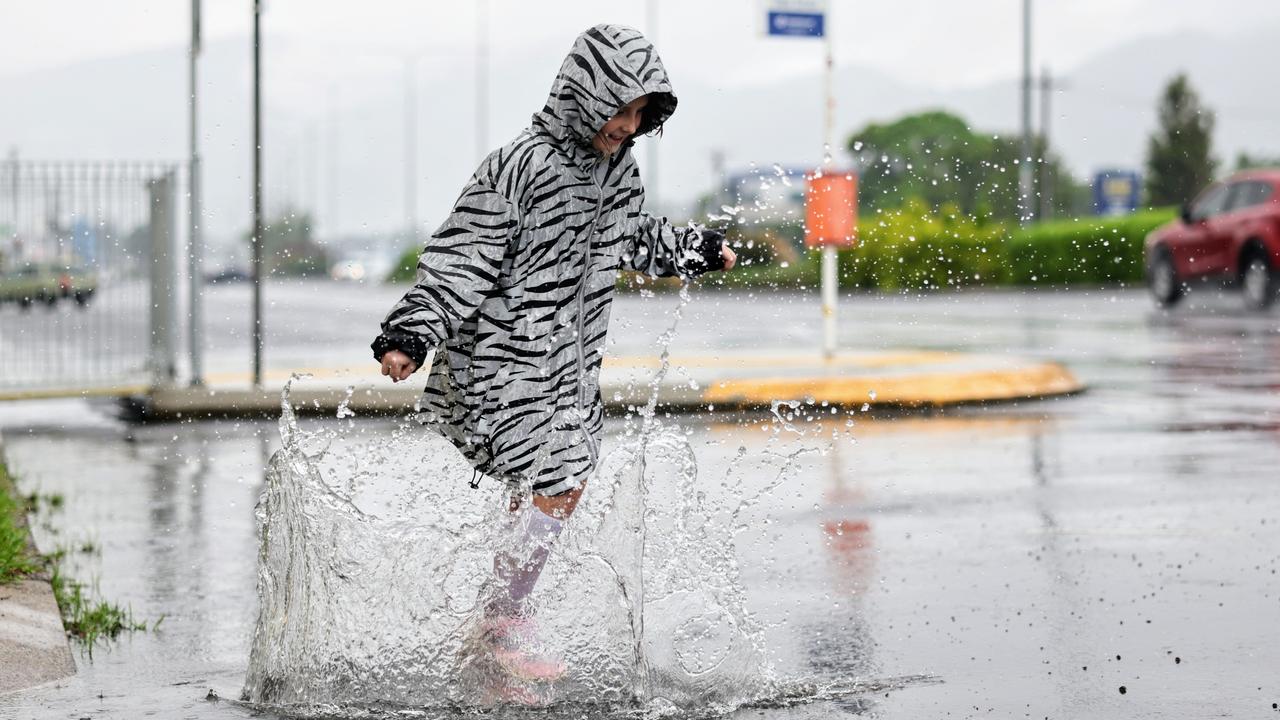
The Bureau has explained how the Far North avoided intense rainfall with patches of blue sky visible on Saturday, as parts of the Cassowary Coast experience moderate flooding.
Cairns
Don't miss out on the headlines from Cairns. Followed categories will be added to My News.
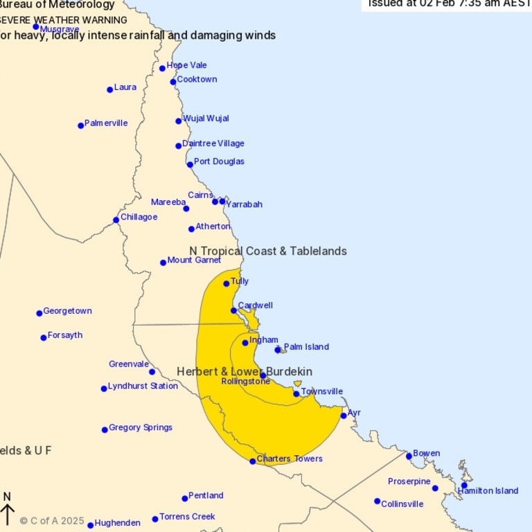
Parts of the Far North remain under severe weather alert, as the brunt of the rainfall impacts coastal areas between Cardwell and Ayr.
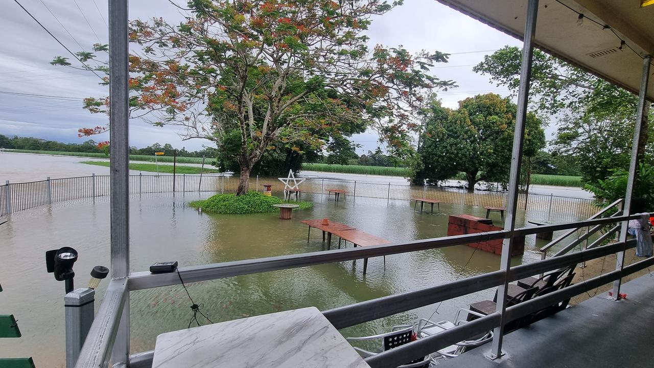
Communities up and down the length of the Bruce Highway have been isolated by floodwaters as of Sunday morning, while Townsville and Ingham have received hundreds of millimetres of rain.
Ingham is facing its most significant flooding event since 1967.
On Sunday morning, the Cassowary Coast Regional Council and Queensland Police Service issued an emergency alert for Cardwell, warning residents in low-lying areas to take immediate action, with flooding already occurring.
“Flooding is occurring in low lying areas and may spread,” the alert said.
“Residents in low lying areas should collect their evacuation kit and move to a safe place on higher ground. This situation may pose a threat to life and property.”
On Saturday, the CCRC had issued two emergency alerts urging residents at Mourilyan to prepare to act, while residents at South Johnstone were called to evacuate, if they were in low-lying areas within the river’s catchment zone.
The South Johnstone evacuation notice was lifted at 10.15am, however residents remain on flood watch.
No other Far North council area had issued any emergency alerts as of Sunday morning.
The Bureau of Meteorology’s Severe Weather Warning at 7.35am on Sunday had moved the warning area further south, covering localities between Tully and Ayr, south of Townsville.
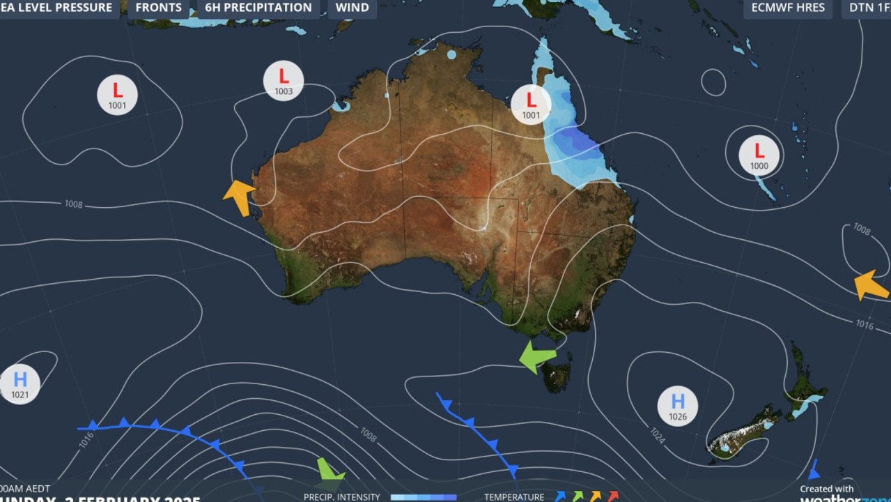
“An elongated low pressure system embedded within the monsoon trough is currently located across the southern Cape York Peninsula resulting in enhanced rainfall and winds about the north east coasts of Queensland. Very significant rainfall accumulations are expected due to the slow-moving nature of the low and trough in an airmass rich in tropical moisture,” the BoM warning read.
Bureau meteorologist Miriam Bradbury said the rainfall difference between Cairns and Townsville had to with the location of the low pressure system, driving the wet weather.
“For much of Friday and Saturday, the low pressure system has been sitting south-east of Cairns, north-east of Townsville (approx off the coast of Lucinda),” she said.
“Low pressure systems rotate clockwise. Typically, for a low sitting off the east coast of Australia, we see the strongest winds and heaviest rain wrapping around the southern flank of the low.
“The low has been largely unmoving, directing these particular wind directions through Cairns/Townsville respectively for some time now.”
While the most intense falls throughout Saturday were between Ingham and Townsville, with Paluma and Rollingstone recording 699mm and 639mm, minor flooding was also occurring in the southern Cassowary Coast towns of Tully and Cardwell.
“Significant rainfall totals have resulted in river level rises across the Tully and Murray River catchments,” BOM said at 7.20am on Sunday.
“Moderate flooding is occurring along the Tully River at Euramo.
“Further rainfall is forecast for the remainder of Sunday into Monday, which may cause renewed or further flooding depending on the location of the heaviest falls.”
The Tully River at Euramo was at 8.75m on Sunday morning, with the Bureau warning it could reach 8.9m by Sunday afternoon. The moderate flood level is 8m.
The Bureau said while there were no observations for the Murray River at Murray Flats, “based on upstream gauge” it was expected that river was above its minor flood level of 7m.
In the 24 hours to 9am, Saturday, February 1, the highest rainfall recorded in the Cairns region was at the Babinda Boulders which received 103mm.
Cairns Racecourse had recorded 36mm, the Kamerunga Bridge Alert was reporting 40mm, Gordonvale had 37mm and had 46mm.
While Cairns residents woke to patches of blue sky on the weekend, the Cassowary Coast had received a hammering overnight, with almost every catchment recording in excess of 100mm in 24 hours.
South Johnstone had received 185mm, while Mourilyan Mill Alert had recorded 212mm.
As a result, South Johnstone Rd at Vic Sivyer Bridge was closed due to flooding.
Near Tully, the Bulgun Creek Alert had recorded 309mm and South Mission Beach received 190mm, with the Tully-Mission Beach road closed due to flooding at Whitings Crossing.
Cassowary Coast Mayor Teresa Millwood at 11am on Saturday said while it seemed “like a normal wet season day” the Local Disaster Action Group was preparing for worst-case scenarios.
Ms Millwood said as of Saturday morning, she hadn’t been notified of any calls for help within the Cassowary Coast.
“The evacuation centres are ready to be activated, but not yet activated,” Ms Millwood said.
“Police have been doorknocking around South Johnstone and Mourilyan telling residents to prepare, especially with the high tide at 11am.
“At the moment it seems like a normal wet season day, and I spoke with Hinchinbrook Mayor Raymon Jayo who said it’s the same down there, but we want residents to know it can turn pretty quickly.”
Earlier: Major flood warnings have been issued ahead of a massive rainfall event expected to impact coastal areas between Cooktown and Cairns in the coming days.
Hinchinbrook Shire Council warned residents of a serious flood event expected to bring moderate to major flooding throughout the lower Herbert area.
At 12pm on Friday the Bureau of Meteorology issued a priority severe weather warning for heavy rain, as councils between Townsville and Mossman made sandbags available to residents.

North Tropical Coast and Tablelands and Herbert and Lower Burdekin districts are all on high alert as the Bureau predicts likely 24-hour rain totals of 200-300mm, with isolated falls of up to 500mm during the weekend.
Heavy rainfall and flash flooding is likely in some areas, with six-hour rainfall totals potentially reaching 180mm and hourly rainfall totals possibly reaching 80mm-90mm likely. Isolated thunderstorm activity is also predicted.
Senior meteorologist Miriam Bradbury said rainfall was expected to intensify between Cairns and Bowen late Friday, with the risk of “life-threatening flash flooding” and damaging winds in some areas.
“In the past 24-hours, showers and thunderstorms have brought widespread rainfall across the coast from Cooktown to Mackay,” she said.
“The system is pulling moisture in from the ocean, directing it towards the land.
“This dangerous weather is expected to continue into the weekend, with daily rainfall totals possibly reaching several hundred millimetres.”
Local disaster management group chair and Hinchinbrook Mayor Ramon Jayo urged residents to finalise their preparations as soon as possible.
The potential for heavy rainfall may continue into early next week and some rain accumulations models have predicted up to 2000mm of rain to some areas between Cairns and Townsville.
“Very significant rainfall accumulations are expected over the weekend due to the slow-moving nature of the system,” the Bureau stated in the latest warning.
The intense rain forecast follows 940mm that fell within the Russell and Mulgrave catchments between Monday and Thursday.
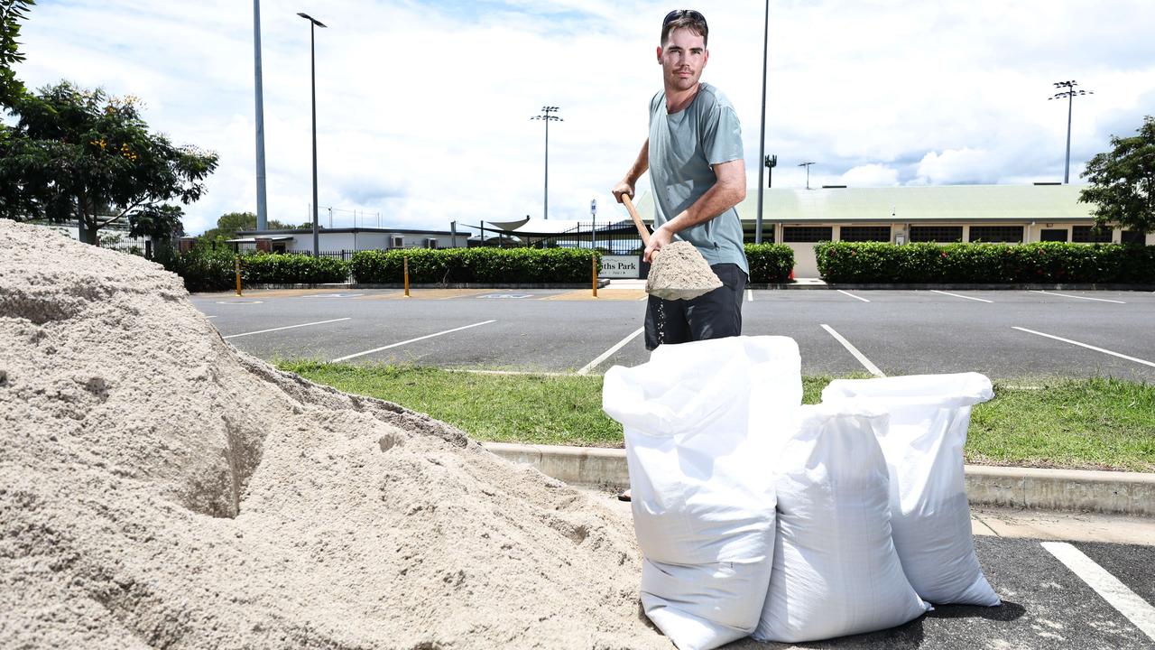
Manunda resident Ben Francoise White took advantage of a free sandbag service provided by Cairns Regional Council to make pre-deluge preparations.
“When we get a heap of rain, there’s nowhere for it to go and obviously the people in lower areas are going to be affected,” he said.
“I don’t think we’ve had enough time for (water) to dissipate properly.
“I think we’re definitely going to see a fair bit of flooding everywhere, especially south of Innisfail, that’s probably going to cop it.
“It is a major concern, for sure.”
âš ï¸Initial Moderate Flood Warning for the Johnstone River Catchment
— Bureau of Meteorology, Queensland (@BOM_Qld) January 31, 2025
MODERATE FLOODING POSSIBLE AT MCAVOY BRIDGE & INNISFAIL WHARF FROM OVERNIGHT FRIDAY INTO SATURDAY
MINOR FLOODING LIKELY AT MOURILYAN MILL FRIDAY EVENING
Heavy rainfall forecast
Details: https://t.co/L9ANKiTD1Fpic.twitter.com/jb0HnWEGkx
The tropical low sitting off the coast of Cairns is driving the wet weather.
Although the system is an unlikely chance of developing into a cyclone, strong to gale-force winds and intense rain are likely to develop south of the low as the system swings back toward the coast late Friday.
Locations potentially impacted by heavy rain include Townsville, Palm Island, Ingham, Innisfail, Ayr, Home Hill, Cardwell, Tully, Giru, Clare and Lucinda.
The risk of heavy rainfall which may lead to flash flooding will increase over the weekend, mostly likely between Innisfail and Ayr, although there is some uncertainty as to exactly where the heaviest rainfall will occur.
Moderate to major flooding is likely across parts of the floodwatch area defined as south of Cairns to Mackay.
Further minor flooding is likely of the Mulgrave River at Peets bridge and Gordonvale from Friday afternoon.
Elevated river levels and flooding is occurring along the Russell River, with further rises likely with forecast rainfall.
A second system over the Gulf is moving southwest and has a low chance of becoming a tropical cyclone by Saturday.

King tides
King tides are occurring in Cairns from Sunday, January 26, to Sunday, February 2, peaking on Thursday, January 30.
Cairns Regional Council has advised motorists to avoid parking in low-lying tidal areas and not to drive through floodwaters, as tidal flooding can damage cars.
Local Disaster Coordinator, Rhys Newton, said council, supported by BOM through their Severe Weather Warning and regular updates on river height levels, was monitoring local weather.
“Yearly king tides are predicted to impact the Cairns region this week, and council crews have been out deploying road signs to advise of salt water inundation,” he said.
Associated road inundation is not expected to be greatly exacerbated by current rain, but please avoid driving and parking in affected areas.
“The Barron, Mulgrave and Russell River heights are currently below minor flooding,” he said.
“We do expect that localised flooding will impact some low-lying roads and bridges, causing interruption to localised traffic.”
Mr Newton said this was a timely reminder for residents to ensure they are prepared for severe weather.
“This includes having household emergency plan and kit, and being familiar with the Cairns Disaster Dashboard,” he sad.
The local disaster co-ordinator said the dashboard was an important tool, as a single point of reference during a disaster.
Visit disaster.cairns.qld.gov.au to view the dashboard.

Late monsoon
Senior meteorologist, Jonathan How said a monsoon is typically declared when a monsoon trough forms at the surface, with winds coming from the west, across northern Australia, bringing heavy rain and cloud cover.
“It hasn’t been declared yet, but conditions are likely to develop on Friday, January 31, which would make this the latest onset in recorded history,” he said.
On Thursday morning, experts said conditions remains too early to determine the “category” of the cyclone, especially since the system developing in the Gulf is now the one to watch.
“Systems in the Gulf can be more unpredictable, given the shallow sea levels. More information will be available once the low develops further,” Mr How said.
The senior forecaster also said it is “quite uncommon” to have five tropical lows active at the same time.
“While it quite uncommon to have five tropical lows active at the same time, typically, there may be a couple, but having five is unusual for the Australian region.
“It’s certainly keeping forecasters busy, with a 24-7 operation closely monitoring changes.”
Mr How said the rainfall, combined with the potential for a cyclone, is part of what’s known as a “monsoon burst”.
“It’s pretty common whenever you get a monsoon burst to see a pick-up of tropical activity,” Mr How said.
Although the official monsoon season has not yet started, he noted for Northern Queensland, it is significant because the first monsoon burst could also bring the first tropical cyclone.
“It’s all sort of connected.”
“We’re keeping an eye on whether we can declare a monsoon and then whether or not a tropical cyclone forms,” Mr How said.
It comes as it’s officially confirmed the north is experiencing the latest monsoon onset on record.
Earlier in the week the Bureau reported the monsoon is still yet to officially arrive, surpassing the previous late-onset record from January 25, 1973.
“The monsoon has been delayed because the broadscale weather patterns associated with a monsoon have yet to develop over northern Australia,” the Bureau said.
Despite receiving over 100mm in 24 hours – a typical wet season day for Tully – nearby publican Tish Ottone of Euramo Hotel described the deluge as “not too bad.”
“The Murray (River) Upper is getting some heavy rain so that’ll be getting close, but for now it’s pretty normal, pretty steady for us,” she said.
“Some schools have started sending kids home, but the (banana and farm) workers are still out there.
“Hopefully we don’t get flooding but for us it depends on what comes from the top (the Tablelands), and that can take normally take a day.”
Ms Ottone joked customers would start to panic soon if the heavy rain continued and do a bulk beer buy.
“They don’t want to get flooded out and run out of beer.”
The Euramo Hotel received national attention late 2023 after a photo it posted went viral, where floodwaters had reached its front door, and patrons used boats to cruise into the pub.
More Coverage


Originally published as Monsoon off Tully shifts severe weather warning south: BOM
Join the conversation

Surprise result emerges in Leichhardt
A surprise result is brewing in the Far North in no small part thanks to preferences from minor parties.
Read more

‘Piggy in the middle’: Katter claims big win in Kennedy
Member for Kennedy Bob Katter is destined to retain his seat this federal election with the maverick MP pushing ahead of the LNP’s Annette Swaine in a crowded eight-candidate race.
Read more

Federal election 2025: Leichhardt live updates, results and latest news
Residents across the Far North will cast their votes to decide who will represent the seats of Leichhardt and Kennedy in the 2025 Federal election. LIVE RESULTS
Read more

Live results from Kennedy federal election
Residents across the Far North will cast their votes to decide who will represent the seats of Kennedy in the 2025 Federal election. Follow live results, here.
Read more

Live results: ‘Probable’ win declared for Leichhardt
Experts have declared who they think will be the next Federal Member of Leichhardt. LIVE RESULTS
Read more

‘Height of my intellectual powers’: How Bob Katter is feeling
The prospect of being an elder statesman in Australian politics may not sit well with maverick MP Bob Katter but the soon-to-be octogenarian has vowed not to act his age if re-elected.
Read more