Road map to saving our reef
How cutting-edge reef forecasting is helping scientists to understand and protect our natural wonder

-
-
While new technologies and big data are helping scientists better understand the health of our most precious natural resource, more importantly, they are helping to save the largest living thing on Earth.
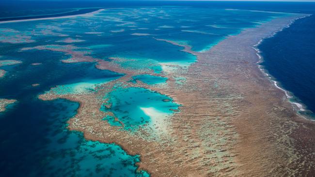
The Great Barrier Reef is one of the seven natural wonders of the world, but its irreplaceable ecosystem, rich coral beds and unique marine life are facing a growing number of threats.
Climate change and rising water temperatures, more severe cyclones, coral bleaching, poor water quality from sediment run-off and pollution, and crown-of-thorns starfish outbreaks, are just some of the threats creating a perfect storm for the reef and marine life that depends on it. But there’s hope.
The Great Barrier Reef Foundation, through its innovative eReefs research project, is providing a road map for the future of the reef. The $30m collaborative project is the world’s first and biggest reef modelling program and is delivering vital, near real-time information about the entire reef, particularly around improving water quality.
The Foundation and its partners have brought together the right people with the latest science and innovation. Working in partnership with the CSIRO, the Australian Institute of Marine Science, Bureau of Meteorology (BOM) and the Queensland government, eReefs is providing a picture of what is currently happening on the reef and what will likely happen in the future.
“The scale of our reef is hard to comprehend and even harder to imagine how you can keep watch over an area the size of New Zealand,” says Anna Marsden, managing director for the Great Barrier Reef Foundation.
“Yet with the growing combination of threats to the reef today, that’s absolutely what we have to do.
“By pioneering eReefs, we can now better understand the impact of poorer water quality from run-off and higher ocean temperatures from climate change.”
Theresa Fyffe, executive director of projects and partnerships for the Great Barrier Reef Foundation, says “eReefs has become a vital tool in improving the water quality”.

Given the scale of the reef, it is impractical to measure and report water quality using monitoring data alone. But, since 2015/16, eReefs has been used to produce the water quality results for the Reef Water Quality Report Card, which details progress towards the Reef 2050 Water Quality Improvement Plan targets.
“With the Australian and Queensland governments using eReefs to set the right reef-saving targets and measures, we can now see the reef in real time as a living, connected ecosystem, from paddock to reef, and from Cape York to South East Queensland,” Fyffe says.
“It highlights to reef managers, industry and the broader community exactly how their actions can impact this unique ecosystem and its marine life, not only in a negative but also a positive way.”
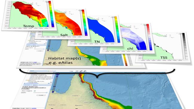
Using the latest technologies to collate data, and new and integrated modelling, eReefs produces powerful visualisation, communication and reporting tools on ocean temperatures, climate change, ocean currents and satellite images and measurements from land catchment activities, flood plumes coming from rivers and extreme weather.
Developed from more than a decade of research, the game changing nature of eReefs also includes the ability to assess the impact of changes in land management practices and weather patterns on critical habitats, such as seagrass and coral reefs.
The BOM, which has been involved in developing eReefs since its inception, has delivered timely access to essential flow and water quality status, and forecasts needed to maintain a vibrant and healthy reef ecosystem.
“Since 1998, up to 15 extreme weather events associated with cyclones, floods, droughts and coral bleaching have occurred leading to a large proportion of sediment and nutrients discharged from catchment to the reef,” the BOM’s Peter Stone explains.
“We’re now able to accurately predict in near real-time what the impact of major rainfall and weather events will be, across the entire reef. This creates a powerful picture of how the whole reef ecosystem responds.
“Before eReefs was developed, it wasn’t possible to measure the amount of water flowing from the land to the reef.
“Now, the data is used by everyone from reef managers, researchers and scientists, to natural resource management organisations who work with farmers to understand how the flow, sediment and nutrients from their regions affect the reef, so they can monitor and report on conditions of the reef in near real time.
“eReefs is leading the way and it’s a system that has the potential to be applied to benefit other locations and scenarios across Australia as well.”
The complex marine and water quality models are being combined with conventional and innovative monitoring technologies to generate predictions which, for the first time, “are reliable enough to allow managers to test a range of long-term options, interventions and prioritise investment”, the Foundation’s chief scientist, Professor Ove Hoegh-Guldberg, says.
“By creating and making publicly available environmental data in 3D for the entire reef lagoon, eReefs has allowed managers, stakeholders and scientists to understand the processes and patterns driving this ecosystem more comprehensively and in greater detail than ever before.”
For environmental scientist Charlie Morgan the information generated from the eReefs program is vital.
“Working with CSIRO scientists, the Healthy Rivers to Reef Partnership better understands the seasonal influences of nearby catchments, which enables us to target our efforts to improve the quality of water flowing out to the reef,” says Morgan, former executive officer of the Mackay-Whitsunday Isaac Healthy Rivers to Reef Partnership.
“eReefs has shown us that catchments as far away as the Fitzroy in Central Queensland have an impact on the water clarity on the Whitsundays. So we are lucky to have such incredible breakthrough technology available to us and supportive partners who can answer our research questions.”
But it’s the “long-term benefits to the Great Barrier Reef that will arise from the application of the eReefs approach”, that Professor Hoegh-Guldberg is most looking forward to. “For example, we are now looking at using the system for identifying the coral reefs that may benefit from adaptation intervention or could be considered as refuges to be protected in perpetuity.”
It is clear that without such breakthrough technology, the outlook is bleak. Saving the reef and its marine life for future generations is a huge task, but there is hope.
