Three Capes Track: Tasmania’s new wilderness trail
Gear up for Tasmania’s spectacular new hiking trail, the Three Capes Track.
We lie in our bunks listening to the wind scream through the marine wire on the balcony outside. Timbers creak and doors rattle, buffeted by gusts that seem to test the strength of our little cabin. Not far away, the Tasman Sea is a heaving blanket of peaks and troughs. Surely this is the kind of weather that brought sailors to their doom on Tasmania’s treacherous coastline.
Fortunately, we are not on some tall-ship voyage into hell and seasickness. We are snug in our room at Surveyors Hut, the first of three overnight stops on the Three Capes Track. Our accommodation is a glorious bastion of architect-designed sturdiness — a steel-framed sculpture of blackbutt, glass and corrugated iron — and it’s not going anywhere in the gale.
The Three Capes opened on the Tasman Peninsula, southeast of Hobart, in December and already more than 4400 walkers have trodden its 46km of paths.
This is a hike for those who don’t want to lug tents and the weighty paraphernalia needed on hardcore multi-day ventures. You must carry a sleeping bag and food, but our two kids, aged 11 and 12, are more than capable of sharing the load, and in fact, the age gap in our contingent of hikers extends from nine to 80. And at the end of each day you are welcomed into a cosy communal hut by a resident Tasmania Parks and Wildlife Service host.
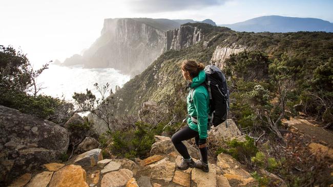
The track experience begins at the World Heritage site of Port Arthur with a one-hour Pennicott Wilderness Journeys boat tour. We keep our eyes peeled for humpback whales, seals, even orcas, but are rewarded instead with an albatross wheeling in the wind and the bobbing head of a baby wedge-tailed eagle nesting in a giant gum. Then the 750kW of four outboards take us for a joy ride in the blustery Tasman Sea, the swell creating a rollercoaster ride that thrills and frightens in equal measure. Afterwards, the crew delivers us to the sand of Denmans Cove — it’s shanks’s pony from here.
This first leg is an easy 90 minute dawdle up a gentle incline. We are immediately struck by the quality of the path. More than 17,000 helicopter flights were made to deposit the materials and muscle needed to build the Three Capes Track.
When you’re not walking on a smooth gravel surface you’re treading the boards of an elevated pine walkway. It means you can enjoy the scenery rather than watch your boots, though we are delighted at one point to look down and find an echidna snuffling in the undergrowth.
On the first night at Surveyors Hut our family of four is assigned a room. These are basic but spotless — two solid timber bunk beds (there are some larger rooms for groups), a bench seat and, notably, no electric lights or pillows. Torches are essential, and a down jacket stuffed into a sleeping bag case makes a perfectly acceptable pillow. Most importantly, the mattresses are comfortable. Nearby is an amenities block with eco-toilets and hand basins. If you want a shower you’ll have to wait till the next night’s hut, which has a clever outdoor bucket contraption for the brave or desperate.
A lot of thought has gone into the communal areas, which do triple duty as cooking and dining hubs, convivial meeting places, and a sanctuary from the elements. Inside are well-equipped stainless-steel kitchens, shelves stacked with books and board games. There are even yoga mats and foam rollers for those wanting to stretch tired muscles.
We set off the next morning in bright sunshine with only 11km to cover. First up is Arthur’s Peak, which isn’t too taxing — the track is designed for those of moderate, not marathon, fitness. At the top we start to see some of the breathtaking views we’ve been waiting for: dolerite columns plummeting to aquamarine depths. To the southwest, Cape Raoul dominates the horizon. If funding goes ahead for the final stage of the track, this will become another highlight on a five or six-day trek. For now, we view it from a distance.
The environment changes throughout the day, from eucalyptus forests to rocky cliff tops and on to the windswept Ellarwey Valley. This coastal heath could have been transplanted from the moors of Scotland. It gains its name from a couple of intrepid bushwalkers who explored this neck of the woods in the 1960s and 70s, and apparently became disoriented: “Where the ’ell are we?”
This is one of many anecdotes in an excellent guidebook issued to all walkers. Its cleverly designed chapters, correspond with creative rest points en route and provide a wealth of information about the area. “Who Was Here?” helps identify the local wildlife via the scat or poo they leave on the track, while “The Lightkeeper’s Daughter” delves into the remote life of those who tended the lighthouse on Tasman Island until the mid 70s.
After a steady five hours’ hiking we emerge from the forest into a clearing and there stands Munro Hut and its magnificent viewing platform perched 240m above sea level pointing to Cape Hauy. With perfect timing, it starts to rain. That night we fall asleep to a damp, percussive soundtrack, wondering what tomorrow’s 17km will bring.
The dawn is clear and promising, but by the time we are stowing our packs for the return trip to Cape Pillar, the weather looks miserable. No matter, though: we have wet-weather gear and soon discover the pleasure of trudging along to the swish-swish of our waterproof trousers.
This is a day full of visual drama. The boardwalk stretches towards the cape like a miniature Great Wall. At times the surrounding tea tree forest is so dark and impenetrable you half expect to see a fairytale prince appear, hacking at it with his sword. At the cliff’s edge in the midst of another squall the rain is forced upwards, bathing the scenery in a crazed, swirling mist. But as we reach the tip of the cape the clouds lift. There’s a nerve-racking, don’t-look-down moment and then we are standing on the Blade, a jagged dolerite ridge that looks out on the lonely lighthouse of Tasman Island.
It’s easy to linger, taking in the spectacular vistas from the Blade, but eventually we make the return trek back to Munro Hut, where we collect our packs and head to the final night’s accommodation, Retakunna. Set in a low eucalyptus scrub, this hut apparently attracts nocturnal visits from wombats, possums and spotted quolls, but if the critters come calling that night, we’re oblivious in our bunks.
Day four brings excellent hiking weather, and we shoulder our packs for the last leg — 14km to Cape Hauy, with Fortescue Bay our final goal. But first we must tackle Mount Fortescue. It’s only 482m high, and the guidebook assures us we “won’t feel a thing”, rather like a dentist tells a patient while firing up the drill. But any pain caused by the climb is soon forgotten on the descent into an enchanting world of moss-swathed logs, high-rise gums and enormous tree ferns. We are immersed in a remnant of the great rainforests that covered Australia millions of years ago. Vibrant fungi in red, blue, purple and orange sprout from the moist earth. It is a truly magical place.
The approach to Cape Hauy returns us to the coast and out to the Candlestick and Totem Pole, two terrifying vertical dolerite stacks that have long lured rock climbers. The drop to the crashing ocean below is dizzying and we’re grateful for the fence that prevents what would certainly be an unfortunate end to our adventure.
Instead, the trek ends without incident in the perfect crescent of white sand at Fortescue Bay, from where a bus transports hikers back to Port Arthur. Along with some fellow walkers we stage a mini-raid on the local kiosk for ice creams and chocolate bars, and experience that otherworldly feeling of returning to civilisation. We’re a little bereft that our Three Capes crusade has come to an end — but that hot shower is going to be good.
CHECKLIST
Bookings are essential for the Three Capes Track. A maximum of 48 people embark on the walk each day. Hikers set off at their own time and pace but inevitably make new friends along the way.
Tasmania’s weather is unpredictable, so layers, warm jackets and wet-weather gear are advisable. The Three Capes Track website has a suggested packing list.
Fresh rain water for drinking is at all overnight huts.
Beds are allocated by the host ranger. Couples and singles may have to share a cabin with others.
Communal huts have charging stations for mobile phones but coverage is limited.
Parking is available for walkers arriving by car. For bus services from Hobart to Port Arthur contact the Tasmanian Visitor Information Network on (03) 6251 2371; tvin@portarthur.org.au.
Walkers receive a two-year pass to the Port Arthur Historic Site.
Tasmanian Wilderness Experiences, which also offers walking tours and transport for bushwalkers in the state, is a good source for hiring hiking gear such as waterproofs. twe.travel
Luxury is in the details at the world’s only Hotel Clicquot
The Champagne maison’s immersive luxury hotel experience returns for a second year, bringing a chic, sun-loving lifestyle to Noosa.

Auckland is calling: Eat, drink, stay and play
Pop over for a luxury weekend escape in Tamaki Makaurau Auckland and unleash your senses – Auckland is calling.