Savannah Way from Cairns to Broome a great Australian drive
The 3700km Savannah Way is one of Australia’s most beautiful journeys.
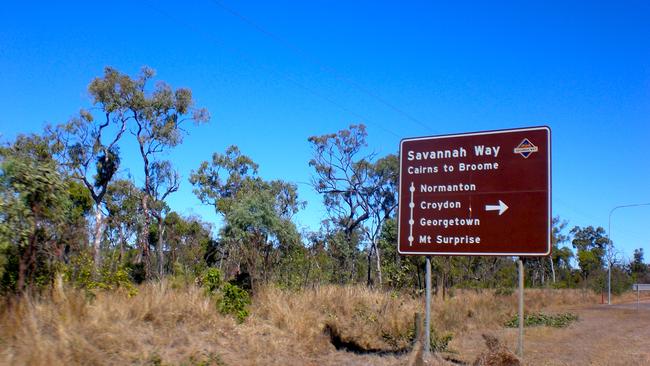
From sea to sea, the 3700km road trip across the top of Australia, known as the Savannah Way, is one of the nation’s most beautiful journeys.
Cairns to Undara
The journey begins at Cairns, from where you snake your way up through the rainforest to the Atherton Tablelands and the market town of Kuranda and on to Mareeba.
This is coffee country — 80 per cent of Australian coffee is grown in the Mareeba area and it’s your last chance for a decent cup for the next few weeks, so head to Skybury Coffee plantation (136 Ivicevic Road, Paddys Green) or Coffee Works in Mareeba (136 Mason Street).
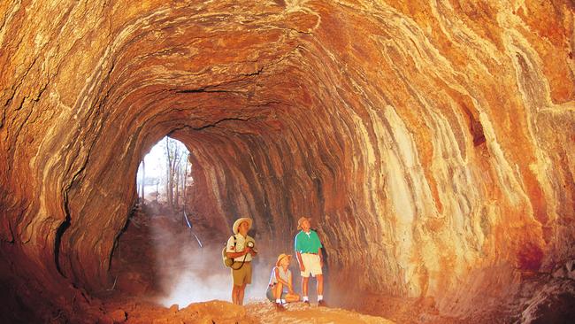
Continue west through Ravenshoe (Queensland’s highest town), stretch your legs at Millstream Falls (the widest in Australia) and spend a night or two at the Undara Experience, where you can explore some of the world’s largest lava tubes on a guided tour. These tunnels, which extend more than 160km, were formed about 190,000 years ago when a large volcano erupted violently, spewing molten lava over the surrounding landscape.
The lava, estimated at 233 cubic kilometres or enough to fill Sydney Harbour, flowed rapidly down a dry riverbed. The top outer layer cooled and formed a crust while the molten lava below drained outwards leaving behind a series of hollow tubes (undara.com.au).
Undara to Cape Crawford
You’ll spend the next few days travelling across the Gulf Savannah — golden, grass-covered plains, where great Brahman cattle roam the countryside in unfenced paddocks that stretch for kilometres. From here on, keep an eye out for road trains and be ready to move on to the dirt shoulder if you see one approaching; watch out for flying stones hitting your windscreen.
Take a break in the historic town of Croydon, so well preserved it feels frozen in time since the gold rush of the 1880s. At Karumba, one of the few towns actually on the Gulf waters, you could spend a day or two fishing and make a nightly pilgrimage to the Sunset Tavern on the point to watch the sun sink into the sea while tucking into fresh barramundi and chips.
Some 70km down the road, at Normanton, the bitumen peters out and it’s a well-made but unsealed road to Borroloola, 700km away. There are river crossings, but in the middle of the dry season these shouldn’t be too dramatic.
Stop at the last campsite of Burke and Wills (Camp 119) and spend a few days exploring the lush oasis of Boodjamulla (Lawn Hill) National Park. Here Lawn Hill Creek cuts through the sandstone countryside to form spectacular gorges, best explored by canoe, which you can hire in the park.
Take one of the several short bushwalks or explore nearby Riversleigh World Heritage Fossil Site, one of the world’s richest, although it does a take some imagination, peering at the fragments of bone embedded in the hillside, to picture the giant marsupials and other strange beasts of which they are the remains. Cross the Northern Territory border and take a 15-minute helicopter ride from the carpark of the Heartbreak Hotel at Cape Crawford over the Lost City, a large expanse of sandstone columns accessible only by air (capecrawfordtourism .com.au).
Cape Crawford to Kununurra
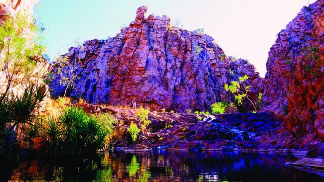
If you’ve had enough of the dust by now, you can hit the blacktop at Cape Crawford and take the Carpentaria Highway to Daly Waters on the Stuart Highway. From Daly Waters, head north on the Stuart Highway to Mataranka. Stop for a dip at Mataranka Hot Springs, before spending a night or two in Katherine. A highlight here is the sunset cruise through Katherine Gorge in Nitmiluk National Park.
From Katherine take the Victoria Highway west to Timber Creek and the West Australian border. From Timber Creek, head west to Kununurra. If the banded domes of Purnululu National Park, aka the Bungle Bungles, in the Kimberley are on your bucket list but you don’t fancy negotiating your way across the wickedly rough 4WD track to get there, you’re in luck: it’s a bit of a well-kept secret but there’s a national park on the Territory side of the West Australian border — Keep River National Park — that has the same geological landforms as the Bungles but with sealed road access.
The best way to see them is on the 7km Jarnem Loop walk that leaves from the Jarnem campground and skates around the rocky escarpment; highlights, aside from close-up views of the banded domes, include spectacular views from the top of the range and a rock-art gallery.
The Kimberley’s youngest town, Kununurra was built in the early 1960s to serve the Ord River Irrigation Project, which created Lake Argyle. The lake is a great place to watch the sun go down with a glass of wine on a sunset cruise (lakeargyle.com). It is also the heart of Durack country, the land of the pioneering cattle-droving family among the first Europeans to settle in this remote area.
Their history is immortalised in the Australian classic Kings in Grass Castles, by Mary Durack, and you can visit the Historic Durack Homestead Museum, the Durack family homestead originally on Argyle Downs Station that was moved to its present site when the lake was proposed.
Kununurra to Broome
Head west out of Kununurra along the Victoria Highway to the junction of the Great Northern Highway and turn south towards Halls Creek. Further south on the Great Northern Highway is Warmun (Turkey Creek), where you can visit the Warmun Art Centre, a studio and sales-exhibition space for local artists. Significant painters from this area include Rover Thomas and Queenie McKenzie, some of whose works now hang in the National Gallery in Canberra, and it’s a great spot to see (and buy) work of emerging artists (warmunart.com.au). Continue south to Halls Creek and west to Fitzroy Crossing.
At Geikie Gorge (near Fitzroy Crossing) take a one-hour cruise with national park rangers and learn about the ecology, geology and history of the gorge. Try to time your trip for sunset, when the walls of the gorge glow a deep, vibrant red.
From Fitzroy Crossing it’s an easy run into Derby and then on to Broome. The port of Derby is on vast King Island Sound; tides here are the largest in the Southern Hemisphere, up to 12m. Stroll along the horseshoe-shaped jetty to see the tidal variation; it’s also a popular place to fish for barramundi and a lovely spot to watch the sunset. Just outside town is the Prison Tree, a big boab with a 2m-high opening and a hollowed-out centre, which was once used to hold prisoners waiting to appear at the local courthouse.
Derby is a good base for scenic flights and cruises to the magnificent Buccaneer Archipelago (derbytourism.com.au). Resort town Broome is 224km to the west along the Great Northern Highway.
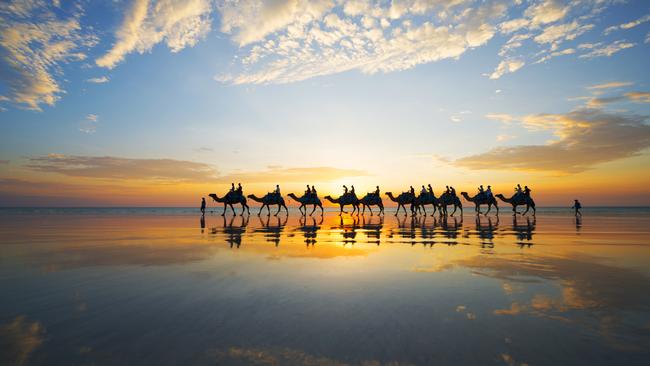
Take a sunset camel ride on beautiful Cable Beach, a 23km expanse of white sand washed by turquoise ocean, wander around historic Chinatown with its unique iron architecture, and check out the jewels this former pearling port is famous for.
In the know
You’ll need at least three weeks to drive the whole route comfortably, but you can break it up into shorter, one-week sections, such as from Katherine to Broome. Some sections are impassable between November and April, so this is a dry season-only drive. The best time to go is between May and October. It’s a long drive through a remote landscape. You’ll need to be willing to camp most nights, and carry your own supplies, including water, and spare tyres. The main route (apart from a 700km section between Normanton and Borroloola) is sealed, but often only for the width of one lane, so you need to move on to the dirt shoulder to pass oncoming traffic; the route is, however, suitable for caravans. There are some 4WD-only detours.
This is an edited extract of Ultimate Road Trips Australia by Lee Atkinson, published by Hardie Grant Travel, $39.99; hardiegrantbooks.com.