The best drives in New Zealand: Milford Sound and the Central Plateau
With Australians able to cross the ditch from April 12, it’s the perfect time to plan a spectacular drive.
New Zealand is renowned for its spectacular scenery, and much of it can be viewed from a car window. A new book, Ultimate Road Trips Aotearoa-New Zealand, by Brett Atkinson and published by Hardie Grant Explore, details some of the best road trips the country has to offer.
Here’s two of the best.
South Island Itinerary: Queenstown to Milford Sound
How long: Driving straight through from Queenstown to Milford Sound will take less than four hours. Plan a couple of nights in either Te Anau or at Milford Sound to make the most of this trip.
When: December to April is the optimum time to visit Milford Sound, with the highest chance of settled weather, and the best opportunity to see Mitre Peak without a shroud of fog. Note, the region’s exceedingly fickle weather means it can rain at any time of the year.
Need to know: Initially started as a workers’ relief project during the 1930s, but not completed until 1953, the Homer Tunnel is one of New Zealand’s most iconic pieces of transport infrastructure. During the peak of summer tourism, you may need to wait about 20 minutes to negotiate the one-way system, but there’s definitely worse places to pass time than surrounded by valleys and mountains. During winter, the road can be closed due to snowfall and occasional avalanches.
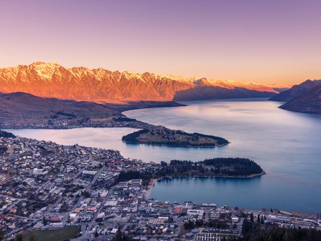
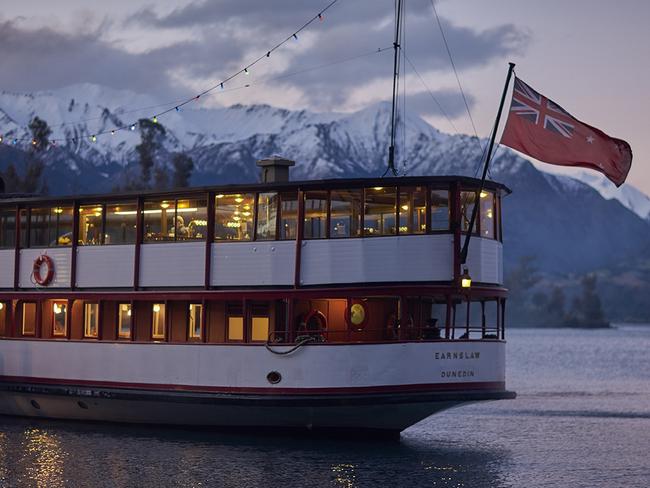
The first part of this journey negotiates the eastern shoreline of Lake Wakatipu, so before heading south from Queenstown to Kingston on SH6, take time to get to know the lake in a few other ways. Departing from Queenstown’s Steamer Wharf, the graceful TSS Earnslaw has been cruising Lake Wakatipu for over a century, and travels up the lake to Walter Peak Station where distractions include an excellent barbecue lunch and displays from quite possibly New Zealand’s smartest sheepdogs.
I focused mainly on craft beer and adventure sports when I was in Queenstown last year, but this relaxing journey was still a real highlight.
Feeling either relaxed or re-energised, depart Queenstown east along the lake’s Frankton Arm, and then turn right at Frankton Town Centre to continue on SH6 south across Kawarau River.
To your left, the jagged indigo profile of the Remarkables mountain range will feel remarkably close, while on the right, the lake’s shoreline is punctuated by high-end housing and the golf course of Jack’s Point. South from Jack’s Point, the road hits the lake’s shoreline at Drift Bay, and continues to wind carefully down the lake’s edge for 30km to Kingston.
The most spectacular lookout is at the Devil’s Staircase, 35km from Queenstown, and a good spot to stop and take in the lake’s cobalt waters framed by the Remarkables and Cecil Peak. Continuing from the Devil’s Staircase, it’s a further 15km to Kingston at the southern tip of the lake. Stop for coffee, cake or lunch at the Kingston Flyer Cafe, housed in the historic railway station, and the traditional departure point for rides on the Kingston Flyer, a 19th-century steam train that makes occasional runs on a 14km stretch of track to nearby Fairlight.
From Kingston, continue on SH6 through the farmland of the Mataura River valley to Lumsden, an archetypal New Zealand junction town with onward destinations including Invercargill to the south, Dunedin to the east, or Te Anau and Milford Sound to the west. Lumsden’s former railway station is now the local information centre, and the Route 6 cafe showcases slightly more modern transportation.
Trout fishing and deer hunting in Lumsden’s rugged hinterland attract return visitors, but for most travellers it’s a good place to recharge before continuing on SH94 for 78km west to Te Anau. This part of the journey largely follows the Oreti River, and after lush farmland plains segue to the elevated Red Tussock Conservation Area, the snow-capped mountains of Fiordland National Park should be coming into view. Stop to take in the conservation area’s blustery amber landscapes before continuing for 45km to Te Anau, and the final stop before negotiating the iconic Milford Highway. It’s a good place for day walks and to book cruises on Doubtful Sound or Dusky Sound.
From Te Anau to Milford Sound is just 120km, but it’s a journey with plenty of worthwhile stops, especially if you’re keen on getting active on excellent short walks. After 28km, stop at the Lake Mistletoe carpark, and amble though a glade of Southern beech trees to the compact alpine lake. Native New Zealand scaup (diving ducks) are usually seen, and the return walk takes 45 minutes. It’s then another 29km following the Eglinton River through the spectacular Eglinton Valley to Mirror Lakes. On a clear day, a five-minute stroll on a wooden boardwalk will reveal superb reflections of the Earl Mountains across the lakes.
At the 76km mark, 19km after Mirror Lakes, the 45-minute Lake Gunn Nature Walk loops through a forest of red beech, and is well-suited to families. Beyond Lake Gunn, there are formidable views of the peaks of nearby mountains at Pop’s View, before the road climbs to enter the Homer Tunnel. It’s strictly one-way, so you may need to wait at New Zealand’s most remote traffic lights before entering the 1.2km-long tunnel, dripping with water, and hewn from rock from 1935 to 1953.
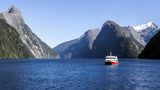
Banks of snow often build up around the entrance to the tunnel, and kea mooch around looking for food. It’s important not to feed them as it disrupts their natural diet. Exiting from the Homer Tunnel to views of the Cleddau Valley, you’re definitely allowed to let out an appropriate expletive. Quicksilver waterfalls cascade down the valley’s mountainous sides, and the thin band of tarmac continuing for 22km downhill instantaneously feels insignificant.
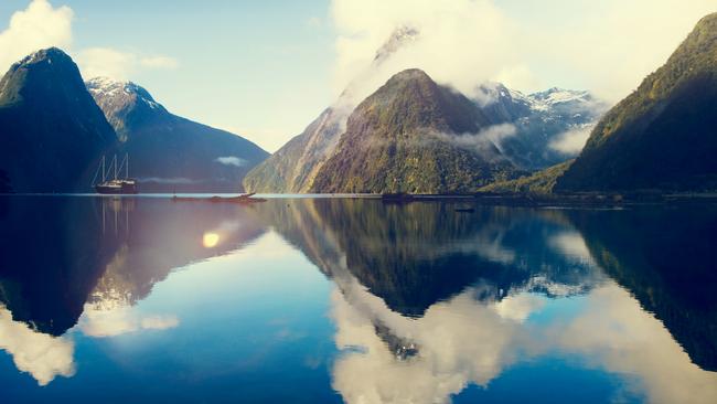
After a short drive along Deepwater Basin Road, the leviathan meeting of land and sea that is the Milford Sound, or Piopiotahi, is finally revealed at the completion of one of New Zealand’s most remarkable road trips.
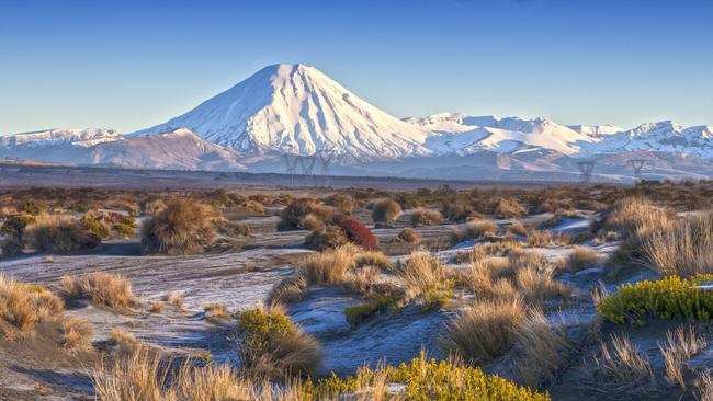
North Island Itinerary: Central Plateau
How long: Four to six days is good for this journey. Add an extra day if either the Tongariro Alpine Crossing or Old Coach Road cycle trail is on your agenda.
When: Spring and summer from November to April are the best times to visit and take advantage of the region’s outdoor activities. March to April can be particularly settled and, outside of Easter, avoids the higher accommodation prices of school holidays later in the year.
Need to know: Tongariro National Park is also popular during winter, with the snow sports season usually running from around July to September. The Whakapapa ski fields on the northern slopes of Mount Ruapehu are best reached from National Park Village and Whakapapa Village, while Ohakune is the most popular base for Turoa on the mountain’s southwestern slopes.
Zip down the Waikato Expressway from Hamilton to leafy Cambridge, and set yourself up for the day with a hearty breakfast. On a Saturday morning, the Cambridge Farmers’ Market offers plenty of gourmet distractions. I’m a big fan of the locally made Cornish pasties. The surrounding Waipa region is known as the Home of Champions, and horse-breeding studs and specialist training facilities for elite athletes feature in Cambridge’s rural hinterland. West of town, the Avantidrome is where New Zealand’s top cyclists train. Kindle Olympic dreams with a one-hour Have-a Go weekend session learning how to ride on the banked track of the velodrome.
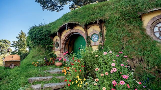
From sporting success to the make-believe of the Lord of the Rings movie franchise, it’s a 30-minute drive east to Hobbiton. Even if you don’t know your Gandalf from your Gollum, it’s great fun exploring the hillside movie set on a guided tour. Experiences conclude with a drink at Hobbiton’s Green Dragon Inn. Either make your own way to Hobbiton, or catch the convenient free bus leaving from the Middle Earth-themed Matamata i-SITE.
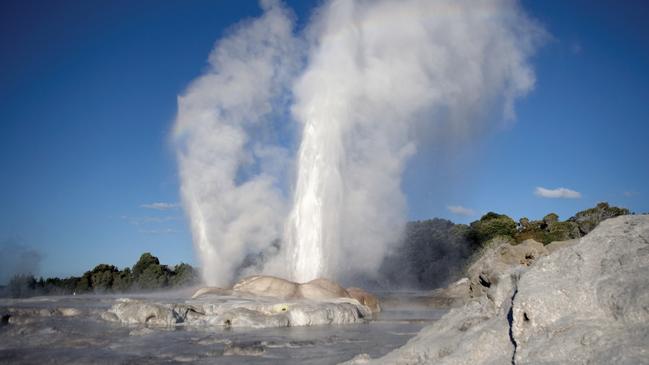
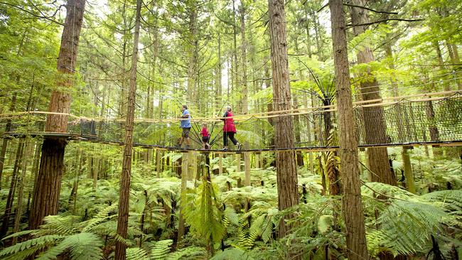
From Hobbiton southeast to Rotorua is 70km, the last part of the journey on SH5 through the forested Mamaku Plateau before emerging to great views of Lake Rotorua. The sulphur-rich aroma is courtesy of the region’s geothermal activity. I was born in Rotorua, so I like the smell; arriving there always reminds me of my childhood. At Te Puia, steaming and bubbling geothermal attractions such as the Pohutu (meaning big splash) geyser combine with the NZ Maori Arts and Crafts Institute and a Kiwi Conservation Centre. East of Te Puia is Rotorua’s sprawling Redwoods, the local name for Whakarewarewa Forest. Explore the Redwoods Treewalk on an elevated platform through the forest canopy. Visiting after dusk when the walkway is illuminated is especially impressive. Other adventurous activities around the region include ziplining in a 1000-year-old forest or twilight kayaking to lakeside hot springs.
Continuing south from Rotorua to Taupo on SH5, divert west on Tutukau Road to visit Orakei Korako. One of the region’s lesser-visited geothermal areas is also one of its most spectacular, and about two hours is needed to explore a dynamic and multi-coloured volcanic landscape. Raised boardwalks snake through Orakei Korako’s Hidden Valley, while exploration of the Ruatapu Cave reveals a jade-green reflective pool reputedly used by local Maori as a mirror in earlier times. Entry includes a scenic boat ride across Lake Ohakuri. Continue west to the junction with SH1 and drive south to Taupo. North of the lakeside city, shapeshifting clouds of steam drift across the road at Wairakei where the region’s geothermal activity is used to generate electricity. Continue via the quieter loop of Huka Falls Road where lookouts offer views of the Waikato River surging through the narrow chasm of the falls. Lake Taupo’s usually benign appearance belies its violent origins in one of history’s biggest eruptions.
On a clear day, lakefront views extend south to the peaks of Tongariro National Park, often snow-capped from June to October. Taupo’s also a worthy competitor to Queenstown as a Kiwi adventure hub, with whitewater rafting, skydiving, parasailing and bungy jumping on offer.

Skirting the eastern edge of the lake, the road dipping and diving around beaches and coves, SH1 continues south for 50km to Turangi. World-renowned trout fishing is the biggest game in town, with local fishing guides sharing secret spots in the area’s back-country rivers. By now, the three peaks of Tongariro National Park – Mt Ruapehu, Mt Tongariro and Mt Ngauruhoe – will be entering your sightline. You may recognise Mt Ngauruhoe from its Hollywood cameo as Mordor’s Mt Doom in Lord of the Rings.
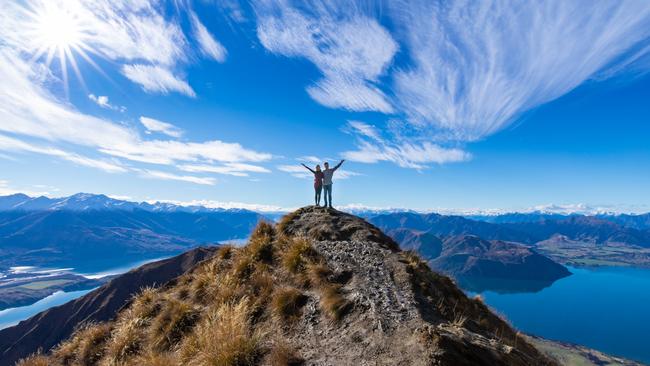
Follow SH47 around the park’s northwestern edge to National Park Village, the best base for tackling the Tongariro Alpine Crossing, regarded as one of the world’s great one-day hikes, best undertaken from November to May.
South of National Park Village, take SH49 to Ohakune, a bustling snow-sports centre in winter, and a popular spring and summer base for the half-day Old Coach Road cycle trail. From Ohakune, it’s also possible to arrange multi-day kayaking or canoeing experiences on the Whanganui River. It’s a 20-minute journey along SH49 to Waiouru and the junction with SH1. New Zealand’s main highway is known here as the Desert Road, and the surrounding area is barren, dotted with hardy tussock vegetation, and at an exposed altitude of 800m above sea level.
Housed in a leviathan concrete building, Waiouru’s National Army Museum is a poignant and interesting showcase of the history of New Zealand’s military operations. South from Waiouru, SH1 continues for 130km to Palmerston North, the provincial hub of Manawatu dairy farming country. Look forward to an energetic vibe, courtesy of students from the city’s Massey University, and the dual attractions of Te Manawa, one of the country’s best regional museums, and the adjacent New Zealand Rugby Museum.
The best of the best drives
Mountain scenery: Central Plateau – Hamilton to Palmerston North; Across the Southern Alps – Christchurch to Greymouth; Mackenzie Country – Timaru to Aoraki-Mount Cook National Park, Queenstown to Milford Sound.
Wildlife: Alpine Pacific Explorer – Christchurch to Kaikoura; Banks Peninsula; Otago Peninsula; The Catlins – Dunedin to Invercargill.
Adventure: Central Plateau – Hamilton to Palmerston North; Around the mountain – New Plymouth to New Plymouth; Tasman Bay – Nelson to Collingwood; Across the Southern
Alps – Christchurch to Greymouth.
Food: East of Auckland; Waiheke Island; Hawke’s Bay; The Crown Range – Queenstown to Wanaka.
Wine: Hawke’s Bay; Wairarapa – Wellington to Martinborough; Marlborough – Picton to
Nelson; Queenstown to Twizel.
Craft beer: Northland; East of Auckland; Haast to Wanaka; Dunedin to Oamaru.
This is an edited extract of Ultimate Road Trips Aotearoa-New Zealand by Brett Atkinson, Hardie Grant Explore, $45.
IN THE KNOW

Three months earlier than anticipated, and nigh on two years since borders closed, a minute before midnight on April 12 will mark lift-off for Australian travellers to return to NZ. Airlines flying the trans-Tasman routes are adding extra capacity to handle the anticipated demand. Qantas and Jetstar have announced up to 30 return services a week, including daily from Brisbane, Melbourne and Sydney to Auckland plus Sydney-Christchurch and a thrice-weekly Jetstar service between the Gold Coast and Auckland. Air NZ has added 90 flights over the Easter period. Virgin is not expected to resume flights until the last quarter of 2022.
In response to pressure from the tourism industry and in line with regional trends and health advisories, PM Jacinda Ardern brought forward the reopening date by three months and has scrapped quarantine procedures and self-isolation protocols. Visitors must be fully vaccinated with a pre-departure negative Covid test and take rapid antigen tests on arrival day and either day five or six in NZ. Face coverings are still recommended in public and an NZ government My Vaccine Pass must be downloaded as proof of health records. Local operators have been quick to release deals and discounts, including seasonal specials to tie in with Australian school holiday dates and snowsports season. Even the destination’s high-end lodges are offering relaunch incentives such as four nights for the price of three and space-available room upgrades at Otahuna Lodge, near Christchurch, for stays between April 13-September 30.
Susan Kurosawa
To join the conversation, please log in. Don't have an account? Register
Join the conversation, you are commenting as Logout