Inside the new luxury lodgings at the Northern Territory’s Larapinta Trail
The multi-day Larapinta Trail tackles rugged terrain, sometimes in extreme temperatures. Here’s how to make it a less arduous undertaking.

It’s midday and we’re minutes from landing at Alice Springs Airport. From my window seat the red centre looks uncharacteristically green. Recent heavy rain has boosted the native spinifex and put a rocket under the buffel grass, introduced in the 19th century but now classified in the Northern Territory as a weed.
I’ve come to do a six-day/five-night walk along the Larapinta Trail, which winds for 220km through the ancient sculpted landscape of the West MacDonnell Ranges. Walkers can tackle the whole trail or part of it, either independently or in a group. The track is generally well marked, but going alone can be a hard slog, requiring prearranged food drops and the ability to carry a heavy backpack over challenging terrain. Temperatures, even in late April, can push well into the 30s, and not carrying enough water can be (and quite often has been) fatal.

I’m here with the Tasmanian Walking Company, which also runs guided walks in its home state and on Kangaroo Island, plus along Victoria’s Great Ocean Road, and I’ll be carrying several litres of water, a camera and not much else. It’s the first walk of the year and there are seven of us in the group – aged between 14 and 64 – plus two guides, Caitlin and Charlie, who take it in turns to lead. Going early in the season means avoiding the sometimes freezing temperatures of a Central Australian winter, but it also means flies, and lots of them.
We meet early on day one for a pre-walk briefing and footwear inspection at a hotel in Alice Springs. Anyone expecting to walk these rugged ridges in running shoes, sand shoes, elasticised boots or similar risks being left behind. New boots must be worn in, even if only on a gym treadmill. Everyone has read the small print and we all pass muster.
A short drive later we disembark the minibus at Simpsons Gap, one of many dramatic V-shaped clefts in the West MacDonnells. Scarlet-beaked zebra finches flit around the parking area, along with an occasional yellow-collared ringneck parrot, but we’re both too late and too early to catch sight of the black-footed rock wallabies that inhabit the red cliffs beside the walking track; they’re most likely to be spotted at dawn or dusk.

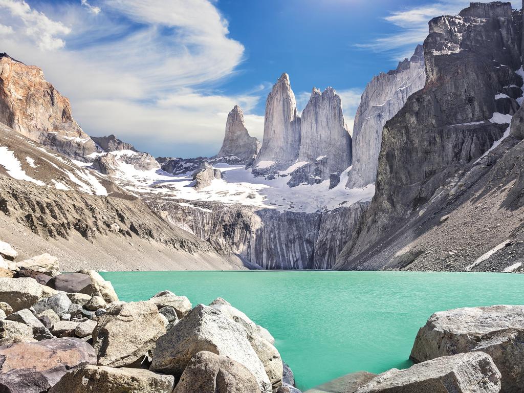
An easy walk from Simpsons Gap takes us on to Hat Hill Saddle and our first panoramic view of the Heavitree Range, one of the three mountain chains – along with the Chewings and Pacoota ranges – that make up the West MacDonnells. A jagged spine of hard red quartzite runs along the ridge above slopes spotted with mallee and spinifex. A billion years ago, these rocks were sediment beneath the sea. Shifting tectonic plates later generated tremendous pressure that warped the landscape of central Australia, bending the Heavitree Range and creating the characteristic lumpy bands in the slopes. Millions of years of weathering have ground away the softer rock, leaving the quartzite exposed.
The ridges burn red in the late afternoon sun as we make for camp, newly upgraded with hot showers and low water-usage flushing toilets in place of the old long-drop dunnies. Unlike previous guests, who slept on mattresses resting on doors from Bunnings, we’ll be snug in new double tents with ensemble beds. We’re warned to store our walking boots in wooden boxes inside the tents, lest they be gnawed by dingoes, which have been known to wander through the campsite at night.

Later in the season, walkers will be able to relax outside on sofas and spend the evenings around a firepit, but to escape the April flies, we head for the communal marquee, where we are plied with beer and wine while camp host Kate prepares a dinner of barramundi baked in tomato, fennel and ginger sauce, followed by pears poached in white wine and saffron. It is the first of many excellent meals she conjures for us out of fresh ingredients delivered to the camp from Alice Springs.
Day two has us heading out after breakfast to section 10 of the Larapinta Trail, which goes from Ormiston Gorge to the Finke River, one of the oldest rivers on Earth. Ripple patterns on the exposed rock suggest that the waterway was running as the mountain ranges were first forming.

Walking west from the gorge, we see in the distance the dramatic profile of Mount Sonder, our destination on day five. The slopes are studded with bloodwood trees sagging under the weight of bush coconuts, and the track is lined with colourful wildflowers – daisies, hibiscus and purple bush tomato – brought to life by the recent rains. Charlie calls a halt to show us a delicate pink flower; its Indigenous name translates as “beautiful but useless”. One member of our group can’t resist quipping: “Just like my husband.”

We cross dry creeks and make our way up to a ridge overlooking Glen Helen Gorge in the Pacoota Range before lunch in a sandy riverbed lined with river red gums. Detritus wrapped around the tree trunks shows how high the Finke River runs when it is in flood.
Finding our way down to the waterhole at Glen Helen Gorge proves tougher than expected. During the off-season, dense vegetation has overgrown the waterlogged track and before long we are plunging through head-high reeds like Cary Grant in North by Northwest. Caitlin, unflappable as always, prods and probes until she gets us back on dry ground.

The next day involves a 16km hike, the longest yet. We climb steeply through a steep mallee and burnt-out mulga forest to one of the parallel ridges of the Heavitree Range to the stunning lookout at Count’s Point. At more than 1100m, this is one of the highest points on the range, offering superb views along the ridge line to Mount Sonder and across the valley to Mount Zeil, the territory’s highest mountain and the tallest Australian peak west of the Great Dividing Range. In the distance, clearly visible through the purple haze, is the ragged rim of Gosses Bluff, the remains of a comet or asteroid strike 140 million years ago that scientists believe blasted a 20km-wide crater in the Earth’s crust.

Day four is shorter but just as exhilarating. We hike around the escarpment of Ormiston Pound, ending with a walk through the gorge of the same name, a chasm between soaring cliffs banded with red and purple quartzite. Curry wattle (it smells like a dusky korma), bush passionfruit and purple desert roses proliferate along the track and a whistling kite rides the thermals above. There is no designated trail through the creek bed and we spend a while scrambling over boulders before hitting a track leading to the Ghost Gum Lookout with its breathtaking view back through the gorge. We search the cliff-face in vain for the rock wallabies that Charlie tells us are there.

It’s a 3am rise for the climb from Redbank Gorge to the top of Mount Sonder. As we set out, an inquisitive dingo emerges from the scrub beside the road and scampers alongside us for several hundred metres. Surprisingly, it’s the only animal larger than a small lizard that we see all week. With head torches to light the way, we cross another dry creek bed and climb for an hour in the dark to wait for sunrise on a saddle a third of the way up the mountain. Slowly the sky lightens and the mountain range on the far side of the valley floor begins to glow. Charlie offers a less arduous alternative to the two-hour ascent to the peak but gets no takers and wanders back alone while we press on to the top with Caitlin.

Winter trekkers are warned about encountering gale-force winds, low cloud and fog, but in mid-April there is little chance of that, and we reach the top under a crystalline blue sky with only the flies to bother us. The trip is 16km up and back over sometimes loose and rocky ground but it’s worth every stumble for the views of rugged mountain peaks and undulating plains.
A walk to Serpentine Gorge on the final morning rounds off the week. The flora here is strikingly different from anything we’ve seen so far. Scattered among the rocks are cycads unique to the MacDonnell Ranges, modern descendants of the primeval cycads that died out with the dinosaurs. River red gums cast shimmering reflections on the water. Alice Springs is 100km and millions of years away.

In the know
Tasmanian Walking Company runs group walks on the Larapinta Trail from April to September. Flies are especially annoying in April, August and September and head nets are a must. Temperatures can drop to zero in winter, and the wind on the ridges can make it feel even colder, so a beanie, polar fleece, thick socks and thermals are recommended. Don’t count on much in the way of mobile reception, although phones sometimes ping at unexpected moments, such as halfway up Mount Sonder. And not even binoculars will help you spy a rock wallaby that doesn’t want to be seen.
Tom Gilling was a guest of Tasmanian Walking Company.
If you love to travel, sign up to our free weekly Travel + Luxury newsletter here.

To join the conversation, please log in. Don't have an account? Register
Join the conversation, you are commenting as Logout