Heatwave: Residents told to leave their homes as bushfire warnings peak
Fires in Tasmania at their most dangerous as stifling heatwave conditions continue to grip the nation.
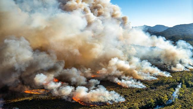
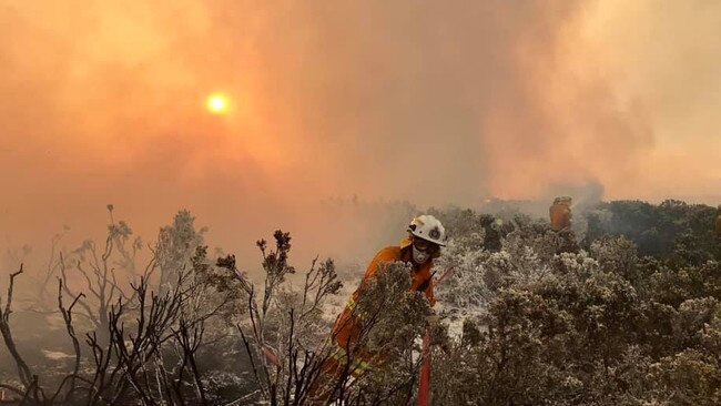
Tasmanians are braced for a day of severe fire risk, with residents in south and central parts of the state being told to leave their homes as heatwave conditions continue to grip much of Australia.
The hazard was set to peak from 5am today, with temperatures in the high 30s and wind gusts of up to 90km/h likely to fan dozens of fires already burning across the state.
Eight new fires started in Tasmania yesterday, adding to 50 others across the state, with two-thirds considered uncontained. Some 64,000 hectares of land has been burned.
Adding to the challenge for fire crews today, forecast winds mean water-bombing aircraft will be grounded.
Hottest day since Black Saturday
The bushfires come as the nation braces for more stifling heat.
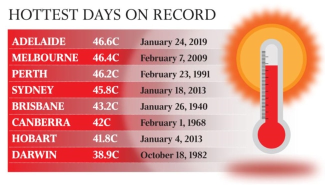
The Bureau of Meteorology has revised its Melbourne forecast to 44C for Friday — the hottest maximum temperature since it hit 46.4C on Black Saturday in 2009.
In Melbourne, it was 30.7C at midnight and 33.6C at 6am.
Thousands of Victorians had spent the hottest night in a year without power, as the temperature struggled to dip below 30C, with about 5800 properties affected by outages on Thursday night.
In Victoria, Melbourne temperatures will peak at 44C by 3pm today after reaching tops of 40.8C at 5.30pm yesterday.
The furnace-like conditions saw play temporarily halted at the Australian Open tennis tournament’s as its player stress heat policy was enacted.
Today’s temperatures are the highest recorded in Melbourne sine Black Friday hit in February 2009.
In Victoria’s northwest, Mildura is expected to reach 47C and Swan Hill 46C.
Adelaide’s recordbreaking heat
The heatwave gripping South Australia yesterday saw Adelaide swelter through its hottest day in 130 years of records, with the mercury hitting 46.2C in the city.
The temperature beat the city’s 80-year-old previous record of 46.1C set on January 12, 1939.
A total of 20 heat records were broken across South Australia, causing blackouts in 20,000 homes and forcing electricity operators to tap into their emergency powers.
.
Spot power prices hit a maximum of $14,500 a megawatt hour compared with average prices of $100/MWh.
Among the records was Port Augusta, 310km north of Adelaide, which recorded the state’s highest temperature of 49.5C.
SA Health expects the number of emergency department presentations for heat-related illness to exceed the 44 that occurred on Wednesday when temperatures hovered around 40C in Adelaide.
Record breaking heat for #Adelaide (46.6°C), the coolest Jan day in 30 years at the airport at #Albany (17.8°C) and Tropical #CycloneRiley moving parallel to the northern #WA coast. #JustAnotherDayInTheBureau 😄 Latest on #CycloneRiley here; https://t.co/i5vKkgfgNu @BOM_SA pic.twitter.com/GTE8YuI5NY
— Bureau of Meteorology, Western Australia (@BOM_WA) January 24, 2019
However, the sweltering conditions will cool off for the weekend dropping to the high-20s.
Sweating on cool change
A cool change is expected to sweep into Melbourne about 3pm, with a temperature drop of 15C in just 20 minutes forecast for the city.
The sharp change will bring gusts of up to 80km/h, thunderstorms and increased fire risk.
The cool change will also bring relief in Adelaide, with more comfortable conditions for the Australia Day long weekend, with a high of 29C expected on Saturday and 28C on Sunday, before rising to 31C in Adelaide on Monday.
Meanwhile the BOM has issued a severe weather warning for Queensland after monsoon conditions spread to Cairns, Mareeba and Atherton. In the capital, Brisbane will hit tops of 32 degrees.
Tropical Cyclone Riley has also strengthened to Category two in Western Australia as it continues moving west away from the Kimberly coast.
In NSW, parts of Western Sydney will hit the high 30s with the highest temperature of 38 degrees expected for Penrith. Australia Day won’t provide any relief with maximum 44C temperatures forecasted.
Canberra will also face scorching conditions and reach 39C by the afternoon. The “severe level” heat will continue over the long weekend.
We've just issued a Tropical Cyclone 🌀 Watch for areas between Mornington Island and Mapoon, including #Weipa. If a tropical cyclone forms, it will be called #CycloneSavannah. A Severe Weather Warning âš ï¸ is current for other areas of #FNQ. All warnings: https://t.co/EOgA1rt1qq pic.twitter.com/kSzst44VSH
— Bureau of Meteorology, Queensland (@BOM_Qld) January 24, 2019
— With AAP
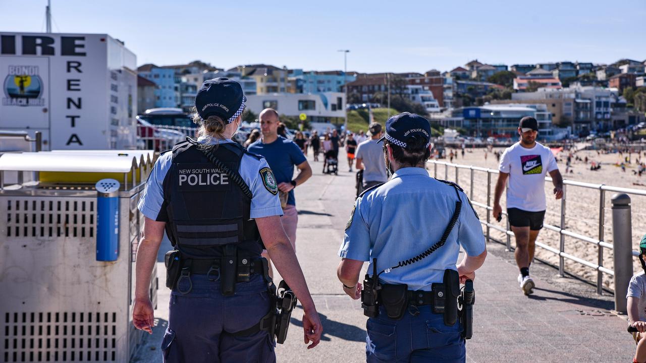
Women egged in anti-Semitic attack at Bondi Beach
Three men allegedly set upon a number of women on Saturday night in Sydney's east, throwing eggs at them, with police believing they were targeted because of the clothes they were wearing.

Nation ‘must not go down road’ of faith-based parties: PM
Parties founded on religion would undermine social cohesion, according to Anthony Albanese, as he reminded rogue senator Fatima Payman that she owed her election to Labor pre-selection.