Cyclone Oma bears down on Queensland, bringing damaging winds and heavy rainfall
Cyclone Oma bears down on the southeast Queensland coast bringing damaging winds and heavy rainfall, after battering the Pacific Islands.
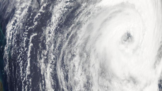
Cyclone Oma has weakened to a category two storm as it continues to move towards the southeast Queensland coast, bringing damaging winds and heavy rainfall. The storm was about 1110km northeast of Brisbane at midday on Wednesday, and was moving slowly towards Queensland.
Latest track map for #CycloneOma, currently a Category 2 system approaching the #Queensland coast. Abnormally high tides, dangerous surf and strengthening winds are expected for coastal areas with heavy rainfall possible from Saturday: https://t.co/KwhEdzKd8H pic.twitter.com/Flyk8Zb9IM
— Bureau of Meteorology, Queensland (@BOM_Qld) February 20, 2019
It briefly intensified to a category three system on Tuesday night but weakened again to a category two storm on Wednesday morning.
In the early hours of Wednesday Oma produced winds of up to 185 kilometres per hour, roughly equivalent to a category one hurricane.
Oma passed through New Caledonia, where high winds cut electricity, destroyed crops, downed trees and shuttered schools and businesses.
New Caledonia’s Civil Security agency reported on Tuesday that around 3,000 people were without power and dozens of telecoms towers were affected.
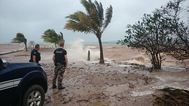
The storm also produced torrential rain in Vanuatu, where clean up operations are under way.
Bureau of Meteorology forecaster Adam Blazak said there was still some disagreement about which path the storm will take, but that there was a possibility it could make landfall on the weekend.
“A crossing is not certain yet, and there are scenarios where it may linger off the coast,” he told AAP.
Mr Blazak said the weather system was already bringing hazardous surf conditions and abnormally high tides.
Tropical #CycloneOma 🌀 is currently southwest of New Calendonia and expected to approach the southern #Queensland coast over the weekend. A coastal crossing cannot be ruled out and the first Cyclone Watch may be issued later today: https://t.co/kL5As5Ml5e pic.twitter.com/rF2ChAqtXa
— Bureau of Meteorology, Queensland (@BOM_Qld) February 19, 2019
Some coastal areas could receive daily rainfall totals of up to 300mm if the cyclone continues its current path.
Mr Blazak said it could also potentially bring much-needed rain to drought- affected inland areas of the southeast corner.
“You don’t really want a crossing,” he said.
“But that would be maybe a better scenario than if it lingers off the coast. “It would end up decaying and dropping rainfall in those dry areas.” A severe weather warning remains in place from the Fraser Coast to the NSW border.
The BoM is expected to issue a cyclone watch on Wednesday afternoon.
AAP/AFP
Women egged in anti-Semitic attack at Bondi Beach
Three men allegedly set upon a number of women on Saturday night in Sydney's east, throwing eggs at them, with police believing they were targeted because of the clothes they were wearing.

Nation ‘must not go down road’ of faith-based parties: PM
Parties founded on religion would undermine social cohesion, according to Anthony Albanese, as he reminded rogue senator Fatima Payman that she owed her election to Labor pre-selection.