Australia braces for cold snap
Australia is bracing for a cold snap with weather warnings issued for Victoria, Tasmania and the Northern Territory.
Australia is bracing for a cold snap with Victorians being urged to batten down the hatches as wild weather lashes the state and Tasmanians warned to prepare for possible flooding.
A severe weather warning was issued today for most of Victoria as a southern cold front is expected to intensify, the Bureau of Meteorology said. Damaging winds of up to 60-70 km/h with possible peak gusts of 90-100 km/h are forecast, as well as rainfall totals of 50-100mm.
The Gippsland Ranges, in the state’s east, could see up to 150mm by Saturday. “There is a risk of flash flooding with that rain. We could see, depending on just how much rainfall, some minor riverine flooding develop,” bureau severe weather manager Steven McGibbony told reporters on Thursday. “With the rainfall and these strong winds, it’s going to feel very wintry and very cold.” “It’s now time to prepare your home, to make sure that the heavy rainfall doesn’t end up inside your home,” SES boss Tim Wiebusch said. He suggested cleaning gutters, securing loose items and moving cars under cover or away from trees.
It only takes 15cm of water for a car to float and people should not attempt to drive through floodwaters, Mr Wiebusch added.
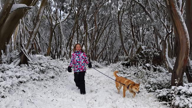
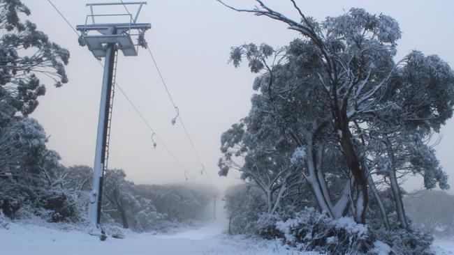
The cold front first hit Victoria on Wednesday night, with temperatures plunging around the state and snow falling to 800m.
Falls Creek, Mount Hotham, Mount Buller and Mount Baw Baw all received considerable amounts of snow on overnight on Wednesday, the Bureau of Meteorology said.
“We’re seeing snow falling to 800m so it’s definitely snowing on the Grampians,” senior forecaster Michael Efron said.

The cold front hit Melbourne just after 10.30pm on Wednesday, with temperatures plunging around the state and now struggling to rise.
“Across the state, we are struggling to see temperatures crack the double digits,” Mr Efron said.
“The mildest temperatures are probably on the bay and in Melbourne. Most of the state hasn’t reached 10C.”
Farmers are being warned to shelter their sheep and lambs, which could die if exposed to the cold conditions.
Tasmanians have been warned to brace for possible flooding and wild weather as a cold front sweeps across southern Australia.
Heavy rain is forecast in southern and eastern parts of the state on Thursday and Friday, the Bureau of Meteorology says.
Two-day localised falls of up to 150mm are possible.
SES crews are on stand-by across the state, with a flood watch warning in place for the eastern half of the island.
“Flooding in streams and rivers is likely during the next few days,” SES assistant director Leon Smith said.
“Some low lying properties may become isolated by flood waters. “People should prepare themselves by moving livestock and equipment to higher ground if possible.” Gale force winds are also expected late on Thursday and into Friday.
Tasmania’s cold front will roll into NSW and the ACT causing the mercury to drop and temperatures to cool significantly.
NSW Fire and Rescue have warned against the risk of household fires with the cooler months seeing a 10 per cent increase due to increased use of heaters and electric blankets.
FRNSW Community Safety and Research Chief Superintendent Mick Morris urged people to stay safe and remember to keep heaters at least a metre from household items.
“Don’t put yourself or your family at risk.” he said. “We want to remind people to be careful when using heaters and to keep everything in the house ‘a metre from the heater’.”
South Australians temperatures will remain steady as a low pressure system develops over the Bass Strait. The state’s sheep graziers are warned that cold temperatures, showers and strong southwesterly winds are expected today and Friday. Areas likely to be affected include the Mount Lofty Ranges, Yorke Peninsula, Kangaroo Island, Mid North, Riverland, Murraylands, Upper South East, Lower South East and North East Pastoral forecast districts and parts of the Flinders forecast district.
A chill will descend over Western Australia with easterly winds blowing through the northern half of the state.
The BOM has issued a marine weather warning for the Northern Territory with wild winds set to hit the Beagle Bonaparte and Roper Groote coasts.
Brisbane temperatures will drop by seven degrees Celsius this weekend as a cold front affecting the southern states extends north.
The city is set for minimum temperatures of 9C on Saturday and Sunday, the lowest for this time of year since 2015, compared to the mid-teen lows felt earlier in the week.
“By the time the cold front gets to us, it’s a dry, westerly wind. So it will be slightly cooler than average conditions,” Bureau of Meteorology forecaster Lachlan Stoney told AAP.
AAP

Women egged in anti-Semitic attack at Bondi Beach
Three men allegedly set upon a number of women on Saturday night in Sydney's east, throwing eggs at them, with police believing they were targeted because of the clothes they were wearing.

Nation ‘must not go down road’ of faith-based parties: PM
Parties founded on religion would undermine social cohesion, according to Anthony Albanese, as he reminded rogue senator Fatima Payman that she owed her election to Labor pre-selection.