Sydney smashes grim climate record and thousands without power as ‘ferocious’ heatwaves sweep east coast
One Aussie city has cracked a grim milestone last set four years ago during a season of catastrophic bushfires.
Sydney has cracked a grim climate milestone last set during the devastating Black Summer bushfires four years ago, as extreme heatwave conditions plague the country’s east coast.
Western Sydney residents are on alert amid warnings of the mercury spiking to 38C on Friday as the inner city swelters through 30C temperatures.
Schools have already been shut across NSW due to the fire danger.
But the real danger lies ahead on Saturday, with parts of the west bracing for temperatures of up to 44C.
The last time such temperatures were realised was during the devastating Black Summer bushfires in 2019/20 that killed 34 people and destroyed thousands of homes, as catastrophic blazes consumed the state.
Just published: 2023 is the warmest year in recorded history.
— Copernicus ECMWF (@CopernicusECMWF) December 6, 2023
2023 has now had six record breaking months and two record breaking seasons - summer and autumn.
What's next? How will the world manage climate risks from #COP28UAE onwards?
Details here: https://t.co/hTINdzl8WKpic.twitter.com/TmlLRiSB95
As well as the heatwave in NSW, temperatures in the 30s are being reported in Western Australia, the Northern Territory, Queensland, South Australia and the ACT.
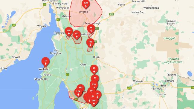
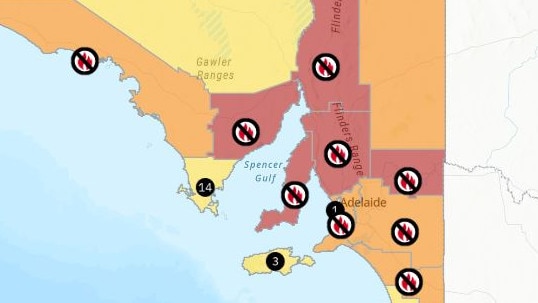
SA in particular is feeling the brunt with firefighters scrambling to contain more than a dozen fires sparked after 30,000 lightning strikes hit the state within a 24 hours period.
Amid the dangerous bushfire conditions, it’s knocked out power to more than 13,000 properties across the Festival State.
At the time of writing, more than 6600 SA Power Networks customers remain without power, with services not expected to be restored until early Saturday morning.
The Eastern Eyre Peninsula, Flinders, Mid North, Yorke Peninsula, and Riverland areas are under catastrophic fire danger warnings for Saturday, while the North East Pastoral, West Coast, Mount Lofty Ranges, Murraylands, and Upper South East areas are at extreme fire danger.
Widespread total fire bans are also in effect throughout.
The concerning spike comes as 2023 is declared the hottest year on global record, according to the European Union’s Climate Change Service.
The last time the record was broken was in 2016.
Climate Council director of research Simon Bradshaw said the record declaration was not a surprise and consistent with what scientists warned would happen as climate change accelerated.
“This ferocious heat and the confirmation that this year is the hottest on record is consistent with what science has warned us to expect,” he said.
He strongly urged Australians to take the advice of local health authorities to avoid the worst of the heat this weekend and reduce their risk of developing heat stroke.
“Heatwaves are silent killers. The human body can only cope with so much and it’s critical that today and over the weekend, Australians heed the advice of their local health authorities, stay vigilant and look after each other,” Dr Bradshaw said.
NSW
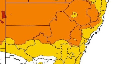
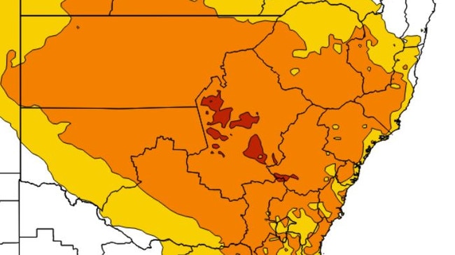
Heatwave conditions have gripped the state for three days.
Severe heatwave conditions have covered most of the north of the state, with a thin band of lower level heatwave reaching from the north to the southern border along the coastline.
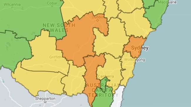
By Friday, spots of extreme heatwave conditions will develop over the Central West Slopes and Plains region, as severe heat pushes towards the coast.
The state government has closed 19 schools due to extreme bushfire risk on Friday, as the danger level rises to extreme levels in parts of southwest NSW, including Griffith, Murrumbidgee and Wentworth.
NSW schools closed due to bushfire risk:
- Barellan Central School
- Binya Public School
- Clare Public School
- Coleambally Central School
- Darlington Point Public School
- Goolgowi Public School
- Hillston Central School
- Lake Wyangan Public School
- Narrandera East Infants School
- Narrandera High School
- Palinyewah Public School
- Pooncarie Public School
- Rankins Springs Public School
- Tharbogang Public School
- Wamoon Public School
- Whitton-Murrami Public School
- Yanco Public School
- Yenda Public School
- Yoogali Public School
South Australia
A severe heatwave has sent temperatures soaring in recent days but is expected to ease on Friday, with southern parts of the state likely to reach a high of 33C as a band of thunderstorms are ushered in.
The small town of Marree, in the north of the state, was the hottest place on Earth on Wednesday, with a high of 46C recorded.
However, heatwave conditions should dissolve by Saturday when a new weather system settles over the south of the country, bringing a potentially dangerous cocktail of weather.
Heavy rain, severe thunderstorms and damaging winds are all possible in the next 48 hours, as a strong cold front sweeps across the south of the country.
The wild weather is forecast to coincide with catastrophic fire danger warnings in place on Friday over the Eyre Peninsula, Flinders Ranges, Yorke Peninsula, Riverland and regions just north of Adelaide.
Welcome relief from the hot weather will arrive on Saturday, with up to 25mm of rain forecast to fall and a possible 40mm by the end of the weekend.
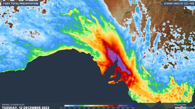
Weatherzone modelling shows between 100mm and 200mm of rain could fall over the seven-day period to Tuesday.
Queensland
From the northern tip of the state and reaching from the east to west border in the south, a severe heatwave warning is in place until Saturday.
Locations likely to be impacted include Aurukun, Birdsville, Cunnamulla, Goondiwindi, Mapoon, Quilpie, St George, Thursday Island, Thargomindah and Weipa.
There is a high fire danger across most of the state on Friday.
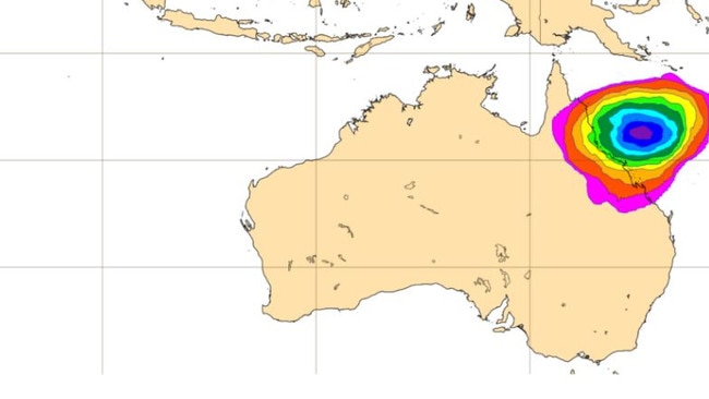
Severe Tropical Cyclone Jasper has strengthened to category 4 intensity on Friday morning and is moving southward through the northeast of the Coral Sea.
Over the weekend, the cyclone is likely to weaken while turning westward towards the Queensland coast.
“While the timing of a coastal impact remains highly uncertain, the highest risk of a cyclone impact lies between Cooktown and Mackay, including Cairns and Townsville,” the Bureau of Meteorology said in their morning cyclone update.
“As Jasper approaches the coast there is a risk of re-intensification and the potential for severe impacts.”

European powers meet Iran in Geneva as war with Israel rages
European powers meet Iran in Geneva as war with Israel rages

Armenia PM to meet Erdogan on ‘historic’ Turkey visit
Armenia PM to meet Erdogan on 'historic' Turkey visit