Two mega-rain events merge causing further flooding: BOM
Thunderstorms and a deluge of rain are predicted to lash NSW and southeast Queensland on Tuesday as a second rain band bears down on the east coast, sparking fears of further flooding.

Thunderstorms and another deluge are predicted to lash NSW and southeast Queensland on Tuesday as a second rain band bears down on the east coast, sparking fears of further flooding, with conditions not expected to clear until Wednesday.
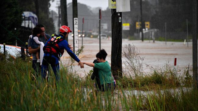
The Bureau of Meteorology warned Tuesday would be another “critical day” as already flooded rivers overflow and volatile storm pockets threaten to bring torrential rain. Heavy rain of 100-200mm, which caused widespread flooding across Sydney’s west, the Hunter and mid-north coast on the weekend, has moved into Queensland.
North Tamborine, near the Gold Coast, recorded 263mm and Brisbane 125mm on Sunday, with about 37mm recorded between 9am on Monday and Monday night in Logan City near Brisbane.
Meanwhile, Kurrajong in the Blue Mountains recorded 174mm, North Richmond 95mm and Penrith 88mm on Sunday, as numerous evacuation orders and major flood warnings were issued on the weekend and Monday.
The mid-north coast was also pummelled by rain, and houses and livestock completely submerged, with Red Oak near Port Macquarie recording the highest total, 889mm falling between Thursday night and Monday.
Tuesday was predicted to be another wet day across the map with 30-40mm forecast for Brisbane, 45-80mm in Sydney and 40-70mm in Port Macquarie.
The rain band was also predicted to move south into eastern Victoria and Tasmania, with Mallacoota predicted to receive between 40-70mm on Tuesday and 10-35mm on Wednesday.
BOM duty forecaster Jonathan How said the second wet weather event was predicted to arrive on the east coast from the Northern Territory by Tuesday, bringing “another critical day” as it merges with the existing rain band. “Into (Monday night) we’ll see these rain masses combine and they’ll merge,” he said.
“We’re really concerned about the rainfall from early Tuesday morning into southern Queensland and Brisbane right down the NSW coast and the ACT and central tablelands into Gippsland.
“There are concerns for heavy rain and the heaviest storms, which could bring thunderstorms.”
Water levels across NSW have risen significantly with at least 16 flood evacuation orders and 14 evacuation warnings active on Monday across the state.
The Hawkesbury River in Sydney’s west is a major concern, peaking at about 13m on Monday, and the Colo River in the northwest was predicted to peak at 14m at Putty Road on Monday night.
Emergency services in Queensland were bracing for flash flooding, with SES Queensland state co-ordinator Brian Cox urging residents in the southeast to avoid unnecessary travel.

Federal jitters as voters tear a brick out of Labor’s ‘red wall’
Labor MPs are warning Anthony Albanese that Victoria’s Jacinta Allan isn’t the only one who should be listening to ‘abandoned’ heartland voters.

Rudd dismisses ‘lies’ over USAID funding for think tank
Australian ambassador to the US, former prime minister Kevin Rudd, has categorically dismissed any claim that he or a think tank he formerly led had received funding from the US foreign aid agency.