Hazardous air quality as brown rain as coats Sydney
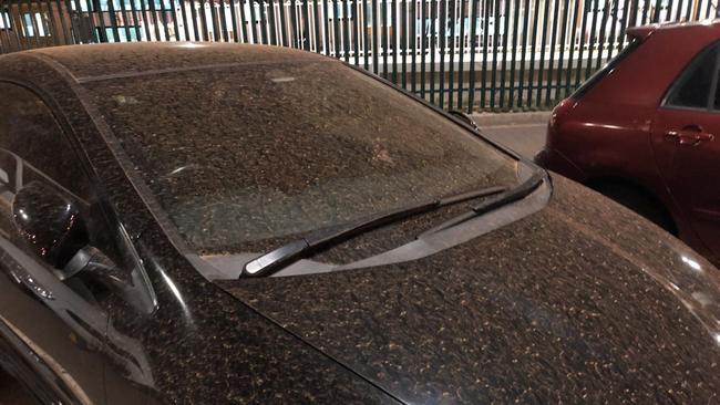
A thick layer of dust covering cars mixed with rain have resulted in turning the city a sepia colour.

Sydney residents who woke to a severe thunderstorm warning have found the city coated with a brown rain, after Melbourne experienced similar conditions on Thursday.
Brown rain occurs when a mix of dust and smoke particles combine with precipitation in the lower atmosphere.
A thick layer of dust covering cars mixed with rain have resulted in turning the city a sepia colour.
“Hazardous” air quality conditions are expected to continue in Sydney city, the northwest slopes and the Southern Tablelands. “Poor” conditions are predicted in the Hunter Region, according to the Department of Planning, Industry and Environment index.
Severe #Thunderstorm warning has been cancelled after bringing hail & rain to parts of city's west & north. Storms are expected to continue most of today for #GreaterSydney which will bring showers and unsettled conditions. Smoke will also hang around from the surrounding fires. pic.twitter.com/VisivvvGLi
— Bureau of Meteorology, New South Wales (@BOM_NSW) January 23, 2020
Sydney residents who sweated through a scorching night, with temperatures still at 30.2C at 12.30am, are now bracing for a severe thunderstorm that will bring damaging winds, large hailstones and heavy rain.
After developing over the Blue Mountains, the “very dangerous” thunderstorm moved east and is expected to hit Sydney during the commuter peak at 9am.
Bureau of Meteorology forecaster Abrar Shabren said after bushfire smoke and dust blew over Sydney, temperatures would remain in the mid 20s in the Sydney and Greater Sydney area today.
âš¡âš¡ A very Dangerous Thunderstorm is moving towards parts of the #BlueMountains #Hawkesbury #Gosford #Wyong & #Sydney. Severe #Thunderstorm Warning for GIANT HAILSTONES, HEAVY RAINFALL & DAMAGING WINDS. For latest warnings visit: https://t.co/bKgH3U9x5k #NSWSES #NSWRFS pic.twitter.com/J7dosXmGzv
— Bureau of Meteorology, New South Wales (@BOM_NSW) January 23, 2020
Mr Shabren said westerly and north westerly winds drove smoke over the city, which will hang around the city for most of the day.
“A combination of dust and smoke is reducing the air visibility and air quality in Sydney,” he said.
Mr Shabren said smoke is coming from the mid north coast Hunter area and Green Wattle Fire.
Fire danger ratings have eased today, with widespread low-moderate and high fire danger following a southerly change that brought light rain and cooler conditions to fire grounds across the south coast. This change has also seen smoke haze return to Sydney and surrounds. #nswrfs pic.twitter.com/jyzTZywBLn
— NSW RFS (@NSWRFS) January 23, 2020
Smoke haze and dust particles drove air quality ratings in Sydney to hazardous levels in the east, northwest and southwest.
At 6.30am, the air quality index that measures the level of harmful particles in the air was 349 in Sydney’s east. Any rating above 100 is considered “poor” air quality.
Sydney’s west had the highest rating in the state, with 564.
The NSW Department of Planning, Industry and Environment advised on its website that people should avoid strenuous outdoor activity.
Took off from Sydney in 42C heat. Flew through red dust clouds and smoke haze, swathes of burnt land beneath. The Chinese are really going the extra mile on this global warming hoax. pic.twitter.com/wiqQRA4MKy
— Chad Loeven (@cloeven) January 23, 2020
Most centres around the Sydney metro area recorded maximum temperatures of about 41C yesterday.
Mr Shabren said humidity levels were also around the 50 to 60 percentage mark, making it feel quite muggy last night.
Observatory Hill hit 28C at 3.30am today — already reaching the expected maximum temperature for Sydney today.
Took off from Sydney in 42C heat. Flew through red dust clouds and smoke haze, swathes of burnt land beneath. The Chinese are really going the extra mile on this global warming hoax. pic.twitter.com/wiqQRA4MKy
— Chad Loeven (@cloeven) January 23, 2020
Weather conditions in the bushfire affected areas in the south coast will ease today.
Bega, Batemans Bay and around the Snowy Mountains will see mild weather today with temperatures in the mid-20s.
Showers and isolated thunderstorm clouds could produce rain on the south coast.
Mr Shabren said it was too early determine if cooler weather and showers would help ease bushfire conditions in and around the south coast.

Weak government response means anti-Semites are winning
The Albanese government must now assume Australia’s Jewish community is under active terrorist attack and set up an Operation Sovereign Borders-type multi-agency campaign to combat the deadly rise of anti-Semitism.
Rise of local terror demands better from our leaders
The scourge of anti-Semitism in Australia has become a runaway train that now demands a radically escalated counter-terror mindset from federal and state governments, police and spy agencies.