The mercury hits 45C as northerly heatwave swallows up east coast ahead of week-long showers
Tropical rains are expected across Queensland, NT and NSW for much of next week, while total fire bans hold across South Australia and Victoria


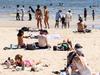
The east coast and parts of central Australia sweltered under a weekend heatwave, sending thousands to beaches and pools, as northerly winds pushed temperatures far beyond national averages, before a southerly cool change was forecast to blow in overnight in some states.
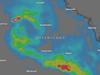
Another round of El Nino temperatures combined with the torrential rains left by ex-Tropical Cyclone Kirrily, leaving much of the Northern Territory’s east, and western Queensland under flood warnings.
Melbourne’s maximum sat at 38C, while Hopetoun airport in the Mallee reached 41.5C.
Central Sydney peaked at 32C, while Wilcannia airport in the state’s northwest recorded 44.5C just before 2pm.
Brisbane’s metropolitan high was also 32C, and the state’s maximum was recorded at Thargomindah in Channel Country, where the mercury hit 41.9C at 1.25pm.
Adelaide’s maximum was 36C, but temperatures soared as high as 44.4C at Wudinna on the Eyre Highway at 2:23pm. Warburton in the North Territory peaked at 45.3C just after midday.
“Heatwaves can be dangerous for everyone’s health, but some people are more vulnerable including people over 65 years old, babies and young children, people with certain medical conditions, people who work outside, pregnant women, people who live alone or are socially isolated and people who are homeless,” NSW Health said.
“If you live in an area where a bushfire is possible, check and follow any emergency warnings associated with threats from bushfires. Prepare now for your health and the health of those around you this bushfire season.”
The Mallee and Wimmera districts in Victoria were placed under total fire ban for the entirety of Sunday, while South Australia placed fire bans in the Eastern Eyre Peninsula, the Mid North, the Yorke Peninsula, the Murraylands, Mt Lofty Ranges and the Upper South East.
The southerly change was expected to break the heat in Adelaide and Melbourne, where temperatures will drop as much as 16C by Monday.
In Sydney, the heat will maintain through Monday as storms and showers set in, a by-product of the tropical storm clouds scattered by Cyclone Kirrily. The rain will maintain through the week as temperatures drop to the mid-20s.
In Brisbane and Darwin showers are unlikely until Wednesday, with no cool change forecast.
More Coverage


Add your comment to this story

KPMG advises Labor to play it smart with AI
One of Australia’s largest accounting firms has warned the Albanese government to tread carefully on artificial intelligence regulation.

Food for thought as Chalmers mulls going with the cashflow
There’s food for thought as Jim Chalmers mulls over the pros and cons of a cashflow tax recommendation from the Productivity Commission.
To join the conversation, please log in. Don't have an account? Register
Join the conversation, you are commenting as Logout