SES leaps into action as wild storms lash two states, with more torrential rains to come
Powerful storms and heavy rainfall is sweeping through Queensland and NSW as both states brace for more wild weather slated for the rest of the week.
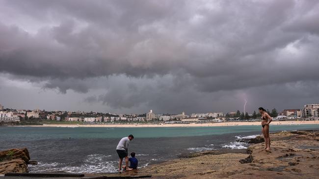
Powerful storms dumping torrential rainfall have swept through Queensland and NSW, as both states brace for more wild weather slated for the rest of the week.
Calls to emergency services flooded the hotlines in both states on Monday, with unpredictable storms sweeping north through NSW as Queensland battled its first cyclone of the season.
Residents in Sydney were hit by a severe thunderstorm that smashed the city at 4.30pm, sparking more than 150 calls to emergency services reporting flooding, fallen trees and leaking roofs.
The rainfall was so heavy in some parts of the city that residents needed sandbags to protect their properties, according to NSW SES spokesman Andrew McCullough.
“We’ve had 150 callouts in Sydney today and 314 across the state,” Mr McCullough said.
“The team is working hard to get those jobs done.”
The storm swept up from the south, where Picton and Shanes Park recorded 20-35mm of rain in just half an hour. Wind gusts of up to 75km/h were recorded in Camden, as well as heavy rainfall in Penrith and Parramatta.
After quickly moving through Sydney, the storm tracked up through parts of the Hunter Valley, triggering the Bureau of Meteorology to issue a severe weather warning for the region.
“The storms have moved through the Hunter, where there’s been heavy rainfall, and there could be some hail there,” BOM meteorologist Gabrielle Woodhouse said. “The thunderstorm going up to Walgett is the most concerning part where we’re looking at heavy rain.”
The NSW mid-north coast was badly drenched on Monday, with reports of flash flooding. NSW SES teams rescued one person who was stuck in their car in Gloucester. Another person was rescued by helicopter after a creek became so high they were trapped in their house.
Queensland also grappled with the fallout from Australia’s first cyclone of the season, which brought heavy rain and cut power to more than 1300 people.
Cyclone Imogen first made landfall at Karumba on Sunday night, causing strong winds, fallen trees and flooding across local road networks. Burketown, Normanton and Mornington Island in the Gulf of Carpentaria were also badly affected.
Emergency crews worked with electricity company Ergon from the early hours of Monday morning to restore power to homes in the area, but had to wait for the gusty winds to drop before they could fly in rescue helicopters.
The heavy rainfall closed all the roads in the area, except for one main road between Cloncurry and Normanton.
Northern Queensland SES assistant commissioner Steve Barber said while the region was used to tropical storms at this time of year, the extensive rainfall left the area prone to dangerous flooding.
“Given that since Boxing Day we’ve experienced quite a bit of rain, the soil is already saturated. It doesn’t take much extra to cause flooding,” he said.
“We are deploying extra swift-water rescue capabilities from Townsville through to Tully just south of Cairns.
“It’s still school holidays and there’s plenty of traffic on the road,” Mr Barber said. “It’s a very popular area for freshwater swimming holes. The rivers are starting to run a bit faster now, so we have to ensure that we are prepared.”

Doctors plot path to halving gap fees
The GP College is pushing for a major lift in the Medicare rebate for long consultations to halve out-of-pocket costs.

‘Dodgy policy’: Queensland government locks in 50c fares
Queenslanders have had 50c public transport fares locked in for the next four years, but not all economists are sold on the $1.5bn commitment.