Revenge of the ex-cyclone: flood risk continues
The flood threat for southeast Queensland and northern NSW from ex-Tropical Cyclone Alfred is not over, as torrential rain continues to bombard the sodden region.
The flood threat for southeast Queensland and northern NSW from ex-Tropical Cyclone Alfred is not over, as torrential rain continues to bombard the sodden region.
There was widespread flooding in Brisbane and the Gold Coast – and a flood emergency in the Wide Bay coastal community of Hervey Bay – on Sunday, and more than 240,000 homes and businesses had no electricity.
Tropical Cyclone Alfred finally crossed the coast on Saturday evening as a tropical low, after spending hours sitting over Bribie Island earlier in the day. Brisbane’s suburbs were lashed with intense winds and heavy rain, as the ex-tropical storm cruised westward, blasting Toowoomba – west of Brisbane – with wind gusts of 98km/h.
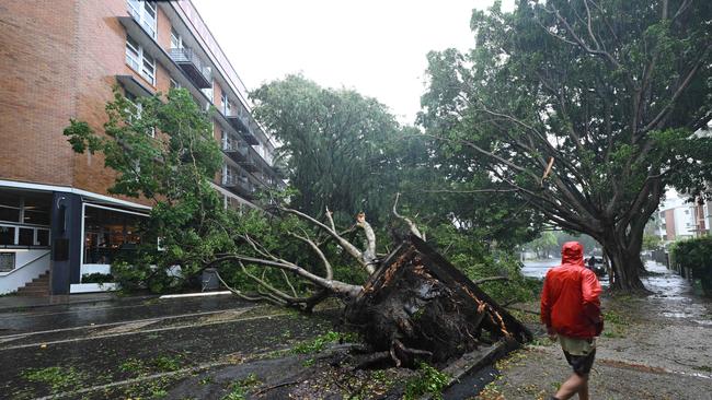
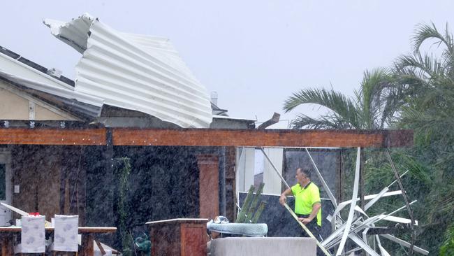
In Brisbane, the roofs of homes were ripped off, trees crashed into homes and businesses, and motorists had to be rescued from cars as the water rose rapidly.
Parts of southeast Queensland recorded large rainfall totals in 24 hours, including Upper Springbrook (276mm), Mount Tamborine (249mm), Mount Nebo (222mm), and Bulimba (165mm).
In the Queensland capital overnight on Sunday, authorities were worried about swollen creeks breaking their banks and causing flash flooding, particularly on Monday’s high tide, and there was a concern that if rain continued, homes would be inundated in low-lying areas.
Flooding continued on the Gold Coast on Sunday night, and residents in Currumbin, Elanora and Tallebudgera were told to go inside and go up high.
Bureau of Meteorology meteorologist Sue Oates said Sunday should be the worst day of rain for Brisbane, and northern NSW would get another day of heavy rain on Monday. But she warned “this event is still not over”.
“The heavy rainfall will continue and flash flooding is a high risk,” Ms Oates said.
The Insurance Council of Australia (ICA) declared an Insurance Catastrophe on Sunday for the southeast Queensland and northern New South Wales regions, which prioritises claims from the storm.
Insurers have received almost 3000 claims in the region hit by Cyclone Alfred and the ensuing tropical low but are expecting more over the coming weeks.
Claims for “storm damage” including from winds and water, coming from above or through homes are part of standard coverage, but only those with flood coverage in their insurance will be able to claim from flooding.
The ICA has estimated that just 23 per cent of properties in known flood-prone catchments across Australia have flood coverage.
There are no plans to release water from Brisbane’s main drinking water reservoirs – Wivenhoe and Somerset dams – despite ex-Tropical Cyclone Alfred drenching the city with rain.
Late on Sunday, 11 of southeast Queensland’s 22 ungated dams were overflowing into the rivers and creeks they were built on, as the region received widespread heavy falls.
But flood water was only being released from one of the water grid’s three dams – North Pine, near Joyner, north of Brisbane – after 170mm of rain fell on the North Pine catchment in 24 hours.
SEQ Water chief executive officer Emma Thomas said that by Sunday afternoon there had still only been relatively small flows of water into the Wivenhoe and Somerset catchments, 31mm and 41mm in the previous 24 hours.
“We are no plans to open the Wivenhoe and Somerset gates at the moment with the rainfall that we can see on the ground at the moment,” Ms Thomas said.
But she said the authority was maintaining “an active watch” on the weather.
“We respond to the water on the ground because weather systems can be really uncertain, and it’s really important that we don’t inadvertently put water into much higher storm surges and water coming in from other areas that may create other impacts,” she said.
More Coverage

Add your comment to this story

WA Libs vote to scrap welcome-to-country, net-zero targets
The moves pile further pressure on Opposition Leader Sussan Ley as she faces a growing Coalition uprising among the party’s dominant conservative faction.

Australia’s PBS must ‘absolutely’ be protected, says Kennedy medical adviser
The chief medical adviser to Make America Healthy Again campaign has defended Australia’s PBS, as the Trump administration comes under pressure to drag the pharmaceuticals program into tariff negotiations.
To join the conversation, please log in. Don't have an account? Register
Join the conversation, you are commenting as Logout