Man dies in Victorian floods; evacuation orders as waters rise in Traralgon
A man is dead and hundreds of residents were told to flee their homes as flash flooding and destructive winds belted Victoria from east to west.
A man is dead and hundreds of residents were told to flee their homes for safety after flash flooding and destructive winds across Victoria belted the state from east to west.
The man in his 60s was found in a car “almost submerged” in floodwaters on Starling Lane, Woodside in the state’s far east about 2pm on Thursday.
“A rescue team has recovered the deceased man and the circumstances surrounding his death are being investigated,” Victoria police said in a statement.
Evacuations
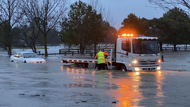
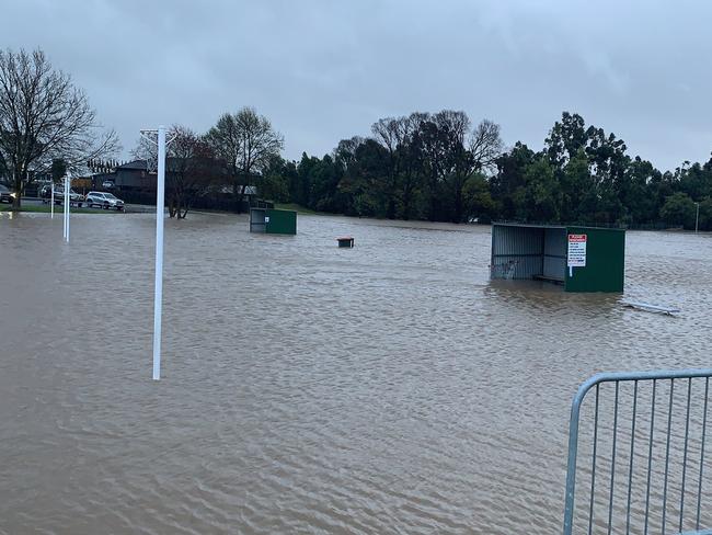
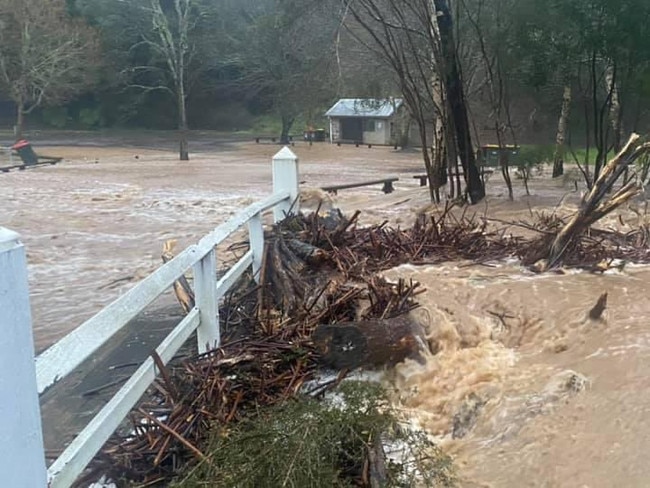
Earlier, Victorians living beside a creek in the state’s southeast were urged to evacuate immediately as floodwaters rise rapidly.
Emergency Management Victoria issued the alert about 10.30am on Thursday for anybody living, working and holidaying in the Traralgon Creek area in Gippsland.
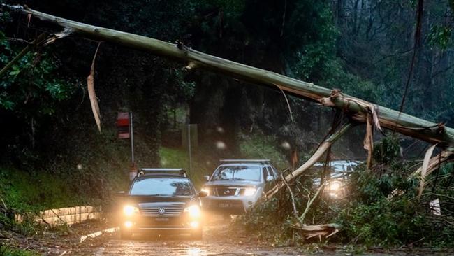
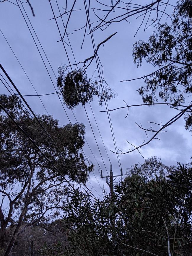
By midday about 250,000 homes across Victoria had lost power due to destructive winds and heavy rainfall overnight.
Victoria’s emergency management commissioner Andrew Crisp said the wild weather hit nearly the entire state.
“What we have seen is significant impact in relation to damaging winds and heavy rainfall from in the east of the state, right through to the western (part),” he said.
“We know that the distribution businesses are working really hard to get power back on as quickly as they can.
Victoria SES operations chief Tim Wiebusch said by midday they had received more than 5000 calls for help.
“Over 3000 of those have been in the metropolitan area of the eastern suburbs and also the southern suburbs,” he said.
“We’ve also seen flash flooding, and other building damage as well.”
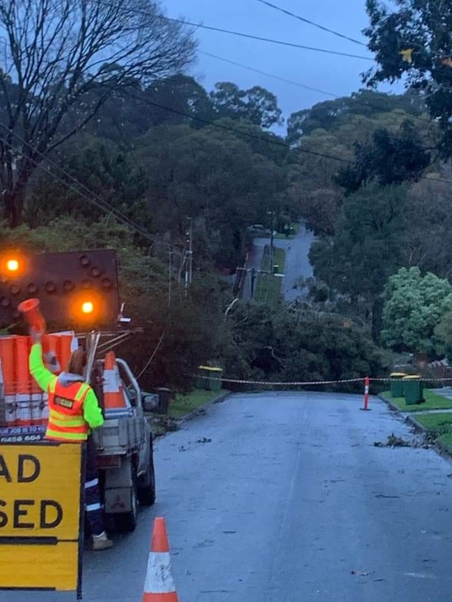
Most of those calls for help - 3,500 - related to fallen trees.
Earlier a Victoria police spokeswoman Sergeant Julie-Anne Newman told 3AW radio roads to Trentham - a town in Melbourne’s northwest - were completely blocked off.
“Trentham is totally isolated with no roads in or out,” she said.
Flooding in the Traralgon Creek is expected to impact the following routes:
- Milton Court, Tennyson Street, Moonabeal Court, Booth Court, Whittakers Road between Shakespeare Street and Princes Street, Davidson Street from the Traralgon Creek to Peterkin Street, Willow Court, George Street, Berry Street, Peterkin Street, Munro Street between George Street and Peterkin Street, Couchs Lane now.
If you are located in these areas it is being urged you evacuate now.
The warning was current to 12:40pm on Thursday.
It’s expected properties may be isolated or inundated and it may be too late to leave, if anybody did not leave before 12.40pm.
Flood - EVACUATE NOW for Traralgon. For more info: https://t.co/k98Tv3Rv96#vicfloodspic.twitter.com/E4n59BSKUM
— VicEmergency (@vicemergency) June 10, 2021
Wild winds wreak havoc in Victoria
Victoria Police pulled off a dramatic rescue in the state’s east after wild wind and rain caused widespread chaos in Metropolitan and regional areas overnight.
🚨BELGRAVE OFFICERS RESCUE MOTHER AND SON
— Victoria Police (@VictoriaPolice) June 9, 2021
Well done to our officers from Belgrave after they walked about one and a half kilometres through the Dandenong Ranges to rescue a mother and son after a tree fell on their home overnight. 🔗https://t.co/mMKRX7HwY2
Officers had to walk more than one kilometre to help an injured mother and her son after a tree crashed through their house in Olinda.
The woman and her son - who were separated by the tree - were trapped and called for help about 11pm on Wednesday. Police had to walk to the pair after their own car got stuck due to fallen trees.
It came after a day of gale force winds - of up to 115 km/H at Wilsons Promontory in the state’s far southeast - and a deluge of rain fell over the state on Wednesday.
As a result of the wild weather, AusNet reported at least 162,000 homes were without power and the worst affected areas were in the eastern suburbs in the Dandenongs, in Gippsland in the state’s far east, the northern suburbs and central Victoria.
“A quarter of the network is out,” AusNet’s Steve Brown told 3AW radio.
“It is the biggest impact anyone can remember,” he said.
He said it was a “safe bet” more than 200,000 properties would be affected and some are likely to suffer power outages in the days ahead.
The SES have reported almost 4,500 calls for help in the past 24 hours with 87 rescues completed.
Nearly 3,500 trees have fallen due to the weather in the state.
The Bureau of Meteorology issued severe weather warnings for large swaths of Victoria in the Central, North Central and parts of South West, Northern Country and West and South Gippsland but said conditions would ease in the morning.
After a wild night of strong, sustained southerly winds, we'll see conditions easing from mid/late morning.
— Bureau of Meteorology, Victoria (@BOM_Vic) June 9, 2021
Damaging gusts still a risk in the warning area over the next few hours💨💨#MelbWeather#VicWeather
Warning: https://t.co/UvueYOHQiipic.twitter.com/lRh7p7wwPu
The highest rainfall totals on Wednesday were recorded in Mount Tassie with 134mm, Thomson-Yarra Divide with 129mm and Balook with 116mm. All areas are about 200km east of Melbourne.
Veteran’s affairs Minister Darren Chester said 100,000 homes in Gippsland were without power and heavy rain is still falling.
“Crews are working to clear tree damage and other impacts from the wild weather,” he said.
The BoM issued flood warnings for the area and expected widespread rain totals of up to 100mm to fall on the region.
“An East Coast Low will bring heavy rainfall to Gippsland and the North East and central ranges during Wednesday and Thursday,” the warning read.
“Catchments in the flood watch area are relatively wet.”
Pictures posted to social media also show serious flooding in Walhalla, a small town 200km east of Melbourne.
Polar air delivers icy temperatures
A blast of polar air has delivered icy temperatures across Queensland and NSW while wild winds and heavy rainfall battered Victoria overnight.
Queensland has shivered through its coldest morning of the year, but snow has so far evaded the state.
Ice pellets did fall on the top of the Granite Belt on Wednesday afternoon, and while it was cold enough for snow near the NSW border, forecasters said it was too dry.
“But if something did come out of the clouds, it would be snow,” weather bureau forecaster Livio Regano told NCA NewsWire on Thursday morning.
Snow chasers are holding out hopes they could still see snowfall later in the morning.
Inland temperatures have been 10C to 12C colder than average on Thursday morning, while coastal parts of the state have shivered through a morning 5C to 7C below average.
âš ï¸Severe Weather Update: Wild weather continues across SE Australia. Video current 1:30pm AEST, 9 June 2021
— Bureau of Meteorology, Australia (@BOM_au) June 9, 2021
â„ï¸ðŸŒ§ï¸Wild weather continues with heavy #rain & the potential for flash #flooding, damaging #winds, & #snow.
Latest Warnings: https://t.co/BA1BJHABF2pic.twitter.com/1BkoOKvfM3
Mr Regano said no records had been broken.
“This is definitely the coldest morning of the year so far and it could possibly be the coldest morning this winter,” he said.
“You only get one or two cold outbreaks like this a winter … this could be the one.”
Wellcamp, near Toowoomba, was the coldest place in the state on Thursday, recording a temperature of -2.7C, but the apparent temperature was much colder.
Cold mornings are expected to continue into next week, but Mr Regano said day time temperatures would warm up over the weekend.
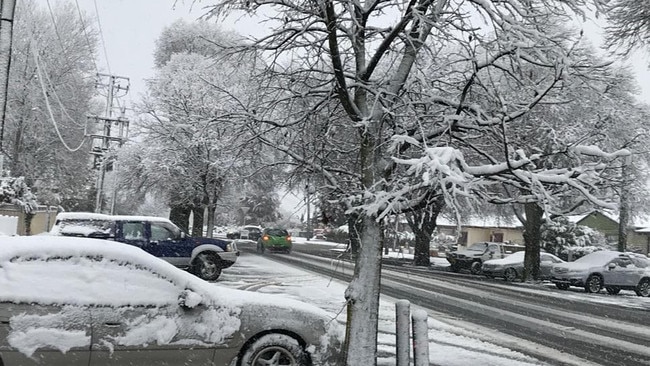
Coldest day in Sydney in 25 years
NSW also shivered through Thursday morning, with Armidale and Glen Innes airports recording respective temperatures of 1.7C and 1.3C at 7.30am, but the apparent temperature was -6.8C.
Sky News meteorologist Rob Sharpe on Wednesday forecast that parts of western Sydney could stay in the single digits all day for the first time in 10 years, while many parts of central NSW could have their coldest day in decades on Thursday.
“The Penrith weather station is likely to have its coldest day in its 25 years history if it stays below 11.2C,” Mr Sharpe said.
“Sydney itself is likely to be colder than last Thursday, but is merely a chance to be colder than the June day five years ago that topped out at 11.7C.”
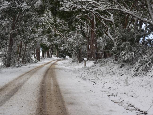
Mr Sharpe said Armidale could see 10 to 20cm of snow on Thursday, and its coldest day in five years.
#NSWweather: Winter is still here! Cold air over southeast Australia bringing more rain today and snow along the ranges. â„ï¸Perisher Valley has received around half a metre of snow. âš ï¸Beware of changing road conditions @LiveTrafficNSW Forecast details https://t.co/yY5JbqBEcOpic.twitter.com/lKMLT96pWo
— Bureau of Meteorology, New South Wales (@BOM_NSW) June 9, 2021
Queensland temperatures at 7.10am on Thursday
Brisbane: 10.9, feels like 7.2
Brisbane Airport: 7.9, feels like 4.5
Coolangatta: 7.4, feels like 3.9
Sunshine Coast Airport: 4.6, feels like 0.4
Kingaroy: -0.8, feels like -2.9
Wellcamp Airport: -0.3, feels like -2.8
Applethorpe: 1.6, feels like -2.9
Stanthorpe: 1.6, feels like -2.9
Roma: 3.3, feels like -0.9
Birdsville: 4.2, feels like -0.7
Julia Creek: 1.8, feels like -2.8
Blackall: -0.8, feels like -3.4
New South Wales temperatures at 7.30am on Thursday
Glen Innes Airport: 1.3, felt like -6.8
Armidale Airport: 1.7, felt like -6.8
Orange Airport: -0.1, felt like -5.7
Mount Boyce: 0, felt like -3.8
Goulburn Airport: 0.5, felt like -3.5
Mount Ginini: -3.9, felt like -9.2
Thredbo Top Station: -3.8, felt like -8
Camden: 0.3, felt like -1.7
Campbelltown: 1.9, felt like -0.9
Add your comment to this story

WA Libs vote to scrap welcome-to-country, net-zero targets
The moves pile further pressure on Opposition Leader Sussan Ley as she faces a growing Coalition uprising among the party’s dominant conservative faction.

Australia’s PBS must ‘absolutely’ be protected, says Kennedy medical adviser
The chief medical adviser to Make America Healthy Again campaign has defended Australia’s PBS, as the Trump administration comes under pressure to drag the pharmaceuticals program into tariff negotiations.
To join the conversation, please log in. Don't have an account? Register
Join the conversation, you are commenting as Logout