NSW weather live updates: NSW Premier declares once-in-a-hundred-year disaster, evacuation warnings for Picton, Richmond
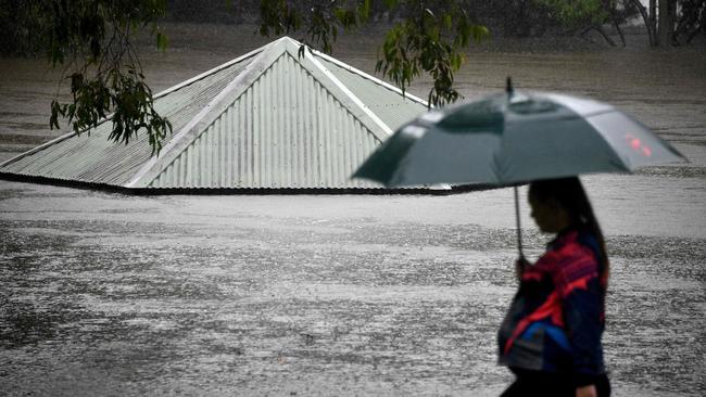
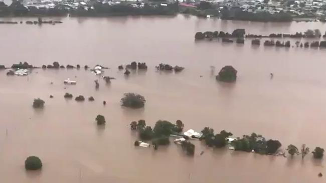
The city of Penrith, west of Sydney, has been inundated as the NSW Premier declares a disaster and warns thousands more will need to leave their homes.
- NSW close to ‘inevitable fatality’
- Floods a one in 100 year event: NSW Premier
- Worst floods expected since 1961: BoM
- Natural disaster declared in parts of NSW
- SES issues evacuation orders, flood warnings
- Queensland Premier sends help
- Weather to delay vaccine roll-out
- Second weather event could bring ‘rain explosion’
- 100mm falls over Sydney and suburbs
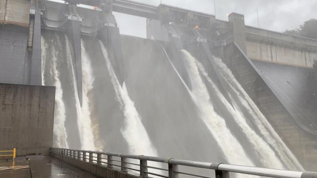
- Warragamba Dam overflows for the first time in years
- Evacuation warnings for south and north west
Welcome to The Weekend Australian’s live rolling coverage of the unfolding weather emergency in NSW.
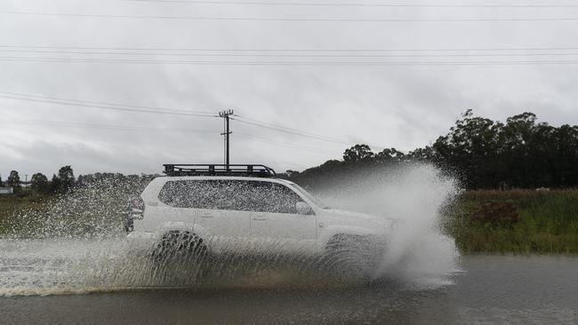
NSW Premier Gladys Berejiklian has described flooding on the NSW Mid North Coast as a one in 100 year event and western Sydney as a one in 50 year weather event, warning that further evacuations are imminent. Authorities are closely watching the Hawkesbury River as it threatens western Sydney communities including Penrith. The weather bureau predicts the weekend’s flooding event in NSW will be the state’s worst since 1961, as a natural disaster is declared in parts of the state.
Stephen Rice10.45pm:Late release of dam water sparks brawl
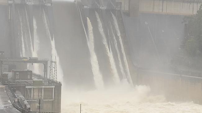
Flood control specialists say water should have been released earlier from the Warragamba Dam, as driving rain led to the dam spilling on Sunday for the second time in two days, threatening thousands of homes in low-lying areas downstream.
The failure to reduce water levels in the dam in recent months despite predictions of destructive weather has sparked a brawl within the NSW government.
Modelling by WaterNSW shows that on current rainfall estimates about 1500 gigalitres of water will flow into the dam in just seven days — 75 per cent of the dam’s total capacity of 2000GL.
Jess Malcolm 10.05pm: Fresh evacuation alerts for Sydney
NSW SES is preparing to issue a fresh alert for residents in the Hawkesbury and Nepean Rivers area to be ready for possible evacuation.
People could be asked to leave their homes as early as Sunday night, as the rain continues to fall causing the river system to become dangerous.
A spokesperson from NSW SES said authorities are monitoring low-lying towns on the river such as Windsor, Richmond and Pitt Town.
“It’s a dynamic river system and we are monitoring it very closely.”
“Residents need to be ready for anything, there could be a very real possibility of people evacuating through the night.”
Rain has eased slightly for residents of the badly-affected mid-north coast, but the area is still of a concern, with rain slated to pick back up on Monday.
Jess Malcolm 9.35pm:Dam released ‘volume of Sydney Harbour’
WaterNSW says Warragamba Dam discharged the volume of Sydney Harbour on Sunday, and is doing “exactly what it is designed to do”.
Approximately 500 gigalitres of water poured out of the dam,.
Water NSW modelling indicates that approximately 1500 gigalitres of water will flow into the dam in the seven days since the extreme weather event commenced, which is 75 per cent of its total capacity.
Flow data up to Sunday morning indicated that half of the floodwaters in the Hawkesbury-Nepean river system downstream of the dam were from tributary flow, not the dam.
The dam — which is Sydney’s main water source — began spilling over at 4pm on Saturday in what experts believe could be the biggest spillover since 1990.
Jade Gailberger9pm:Bushwalkers rescued as flood calls surge
Two bushwalkers in the Blue Mountains have been rescued after they became stranded while hiking in heavy rainfall.
Emergency services remain on high-alert across the state as record-breaking rains and raging floodwaters threaten homes and lives in low-lying areas along the NSW coast.
A severe weather warning, including heavy rainfall and damaging winds, has been issued for people in the Mid North Coast, metropolitan Sydney and parts of Northern Rivers, Hunter, Illawarra, Central Tablelands, Southern Tablelands, southwest slopes, the Snowy Mountains, ACT and Northern Tablelands.
Another 750 calls to emergency services were made on Saturday, including from two bushwalkers returning from a camping trip around 2.30pm on Saturday.
Jess Malcolm8.45pm:Record flood along Hawkesbury River
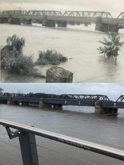
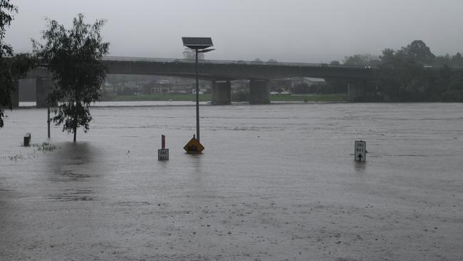
Major flooding is occurring along the Hawkesbury River at North Richmond, in Sydney northwest, with the Bureau of Meteorology warning it is likely to be higher than any floods experienced in the area since November 1961.
Heavy rainfall from upstream in Penrith is causing the river to rise sharply, with major flooding expected at Penrith, Windsor, Sackville, Lower Portland and Wisemans Ferry from late on Sunday.
MAJOR FLOODING HIGHER THAN THE 1961 EVENT EXPECTED ALONG THE HAWKESBURY RIVER
— NSW SES (@NSWSES) March 21, 2021
Major flooding is occurring along the Hawkesbury River at North Richmond where the river level is rising. Flooding is likely to be higher than any floods since Nov 1961. https://t.co/k27HxGqmMG
The river is expected to reach more than 16m at North Richmond on Monday morning, with further rises possible.
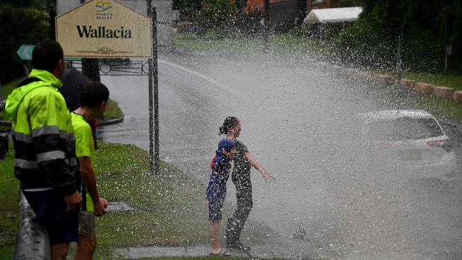
The BOM said moderate flooding is also possible along the Nepean River at Menangle and Wallacia.
Moderate flooding continues along the Colo River, with major flooding possible from Sunday evening.
Further heavy rainfall has been recorded across the Hawkesbury Nepean Valley during Sunday, with more heavy rain forecast for Monday and Tuesday.
Rhiannon Down8.15pm:Flood warnings in northern NSW
A major flood warning has been issued for the Camden Haven River at Logans Crossing and Laurieton south of Port Macquarie, with water levels peaking on Sunday at 9.3m.
“Major flooding is occurring at Laurieton exceeding the 1978 record flood level, where a peak of 2.47 metres was observed around 8:00 am,” SES NSW said.
âš #MAJOR#FLOODING POSSIBLE FOR CAMDEN HAVEN RIVER AT LOGANS CROSSING AND LAURIETONâš
— NSW SES (@NSWSES) March 21, 2021
Major flooding is occurring along the Camden Haven River at Logans Crossing, where a peak of 9.3 metres was observed around 2.00 am Saturday. More: https://t.co/mPN4Wl71ig
Images from social media show houses and businesses submerged under water after the water level rose significantly on Sunday.
New flood warnings have also been issued for the Hastings River in Port Macquarie.
“The Hastings River at Kindee Bridge and Wauchope are expected to exceed major flood levels in the next few hours, with the Hastings River at Settlement Point likely to exceed the moderate flood level in the next few hours,” NSW SES said.
“With further rainfall on Sunday afternoon, flood levels may reach levels similar to the peaks seen on Friday and Saturday.”
Moderate flooding continues along the Colo River on the Central Tablelands, with the possibility of becoming major on Sunday night.
Minor flooding also continues along the Paterson and Williams Rivers in the Hunter Valley catchments, with water levels rising again.
“Further rainfall may occur during Sunday and into Monday, and this may cause further river level rises,” NSW SES said.
#NSWfloods (a) looking across Camden Haven River from Laurieton side towards Dunbogan and (b) Larieton Club - was the evacuation centre before part of it had to be evacuated - car park, wharf and boat ramp gone under pic.twitter.com/0mikiwWge0
— Stan (@StanH2443) March 21, 2021
Alister McMillan6.45pm:Flooded runway closes Newcastle Airport
Newcastle Airport has been closed until Wednesday after the airfield north of Sydney flooded.
“All people booked or looking to fly to and from Newcastle Airport between Sunday evening and Midday Wednesday should contact their airline directly for more details,” a statement said on Sunday night.
âš ï¸ ALERT: Newcastle Airport runway closed due to flooding. âš ï¸
— Newcastle Airport (@NTLairport) March 21, 2021
As of 6.10pm Sunday, 21 March, flights in and out of Newcastle Airport have been suspended, until Wednesday, 24 March. Passengers should contact their airline directly for more details. pic.twitter.com/ijbY8SXnFz
Alister McMillan6.10pm: School closures near 100
The number of NSW schools closed because of flooding has grown to 94, according the state Education Department.
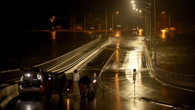
Rhiannon Down5.45pm:Evacuation orders widen in Sydney’s west
Residents in Penrith in Sydney’s west have been issued evacuation orders.
“NSW SES is directing people within the western parts of Penrith to evacuate the high danger area using the Memorial Avenue on to the Great Western Highway on to Victoria Bridge towards Emu Plains,” the SES said.
â€¼ï¸ FLOOD EVACUATION ORDER - WESTERN PARTS OF PENRITH. Evacuate by 4:30pm 21 March 2021, using the Memorial Avenue onto the Great western highway onto Victoria Bridge towards Emu Plains.
— NSW SES (@NSWSES) March 21, 2021
Full details and streets included in order at: https://t.co/mHXVLW6KHJ
“Water is already entering the rear of properties along Ladbury Avenue.
“The evacuation is for all properties within the area bounded by the Nepean River, south of the Great Western Highway and west of Peach Tree Creek. Includes: Captains Road; Fitch Avenue; Ladbury Avenue; Memorial Avenue; Nepean Avenue; and Recreation Avenue.”
Evacuation orders are also expected to be issued for areas surrounding the upper and lower Mooney Dam near Gosford on the Central Coast, with the reservoir expected to spill imminently.
“Heavy rain over the last 24 hours has caused the Lower Moony Dam to start to spill,” NSW SES said.
“NSW SES is advising residents downstream of the Lower Mooney Dam to prepare to evacuate.
“Residents should monitor the situation and be prepared to evacuate when instructed to do so.”
Rhiannon Down4.50pm:West Penrith residents ordered to evacuate
NSW SES has issued an evacuation order for Jamisontown in western Sydney, after the Nepean River overflowed threatening to cut off roads.
Residents in the western end of the suburb have been urged to leave their homes by 9pm Sunday to avoid rising flood water wreaking havoc.
â€¼ï¸ FLOOD EVACUATION ORDER - WESTERN PARTS OF PENRITH. Evacuate by 4:30pm 21 March 2021, using the Memorial Avenue onto the Great western highway onto Victoria Bridge towards Emu Plains.
— NSW SES (@NSWSES) March 21, 2021
Full details and streets included in order at: https://t.co/mHXVLW6KHJ
“The evacuation order is for all properties within the area bounded by Jamison road, Surveyors Creek, Blaikie Road, Rear of Penrith Homemaker Centre, Western Motorway and Nepean River,” NSW SES said in the alert.
The SES said rising water levels threatened to engulf the main highway out of the area, potentially leaving residents stranded and without power and supplies.
‼ FLOOD EVACUATION ORDER WESTERN PART OF JAMISONTOWN. Evacuate by 9pm Sunday 21 March 2021 using the Great Western Highway Evacuation Route.
— NSW SES (@NSWSES) March 21, 2021
Full details: https://t.co/2hoftIASds
“Once flood water reaches 10.66m the Great Western Highway evacuation route will be cut,” it said.
“If you remain in the area after 9pm Sunday 21 March 2021 you may be trapped without power, water and other essential services and it may be too dangerous to rescue you.”
An evacuation centre has been established at Castle Hill RSL at 77 Castle St, Castle Hill.
Rhiannon Down4.21pm:16 LGAs to receive federal funding
The federal government has unveiled new emergency funding to assist communities that have been impacted by the devastating floods in NSW.
The Commonwealth-State Disaster Recovery Funding Arrangements support package will assist affected residents who have lost their homes or belongings as well as local councils with the clean up.
It will also offer support to small businesses and primary producers through concessional interest rate loans as well as offering freight subsidies for producers and grants.
Emergency Management Minister David Littleproud said 16 local government areas would be able to access the funding, after a natural disaster was declared in large parts of NSW.

“This is a serious event with heavy rainfall, severe winds and widespread flooding,
resulting in a high number of flood rescues, damage to roads and properties and a large-
scale, multi-agency response led by the NSW SES,” Mr Littleproud said.
The full list of LGAs eligible for assistance include: Armidale, Bellingen, Central Coast, Cessnock City, Clarence Valley, Coffs Harbour City, Dungog, Kempsey, Lake Macquarie.
Rhiannon Down3.36pm:Heroic livestock rescue
A NSW SES crew has staged a heroic rescue, bringing two goats to safety after they became trapped by rising flood water.
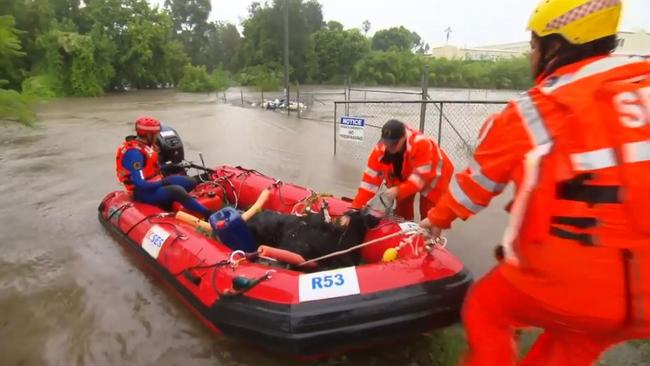
Footage of the rescue shows responders ferrying the bedraggled goats across raging floodwaters at South Creek in Windsor, in Sydney’s west, in a boat and carrying them to safety.
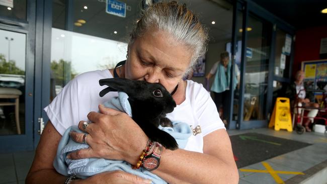
The torrential rain has endangered pets and livestock with more than 2000 residents banding together in a Facebook group to locate lost animals.
Some residents heartfelt pleas asking if anyone had seen their missing animals, as pets and livestock get spooked by rising flood waters and run away or were forced to be left behind by their owners.
Others offered help and a safe place for those on lower ground to leave their animals.
Cliona O’Dowd 3.20pm:Insurers brace for rush of flood claims
Insurers are bracing for payouts in the hundreds of millions of dollars as NSW is devastated by once-in-a-lifetime floods.
As torrential rain lashes NSW, the flooding, deemed to be the state’s worst since 1961, has swallowed roads, destroyed homes and triggered evacuations, with further damage expected in the coming days.
For general insurers IAG and Suncorp, there is suddenly a question mark over the prospect of remaining under their natural hazard allowances for the six months through June as they contend with the one-in-100-year weather event.
Claims have already started to pour in but will ramp up in the coming days and weeks and will run into hundreds of millions of dollars, if not more.
Senior banking and insurance analyst at Velocity Trade, Brett Le Mesurier, said the fallout from the wild weather event would be big enough to force insurers to tap their reinsurance cover.

Reinsurance sees insurers transfer portions of their risk portfolios to other companies, to protect against having to pay out large sums from insurance claims.
“It seems to me this will be a significant event that will call on the reinsurers,” he told The Australian.
“The (general insurers) will be using the various reinsurance covers they’ve got to partially pay for this.”
Mr Le Mesurier declined to give an estimate of the potential cost to insurers, saying it was too early to tell.
Floods rank as among the most costly events for insurers, given extensive damage to businesses and households that are impacted by rising waters. At the same time the number of traffic accidents also increases.
Rhiannon Down3.00pm:Evacuation order issued for Sydney’s North Richmond
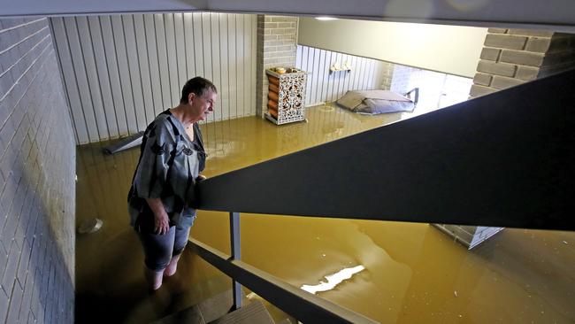
North Richmond has been inundated by flood water, as persistent rainfall pushes the Hawkesbury River to the point of overflowing.
The NSW SES has issued an evacuation order for low lying properties in North Richmond, in Sydney’s northwest, due to rising flood water.
“Major flooding is occurring along the Hawkesbury River at North Richmond where the river level is rising,” NSW SES said.
“Flooding is likely to be higher than experienced in the February 2020 flood event and may reach similar levels to the April 1988 flood event along the Hawkesbury River.”
âš MAJOR FLOODING occurring along the Hawkesbury River at North Richmond. River level is rising. Flooding is likely to be higher than experienced in the February 2020 flood, may reach similar levels to the April 1988 flood event. More: https://t.co/yJFKTiBlC7
— NSW SES (@NSWSES) March 21, 2021
Images shared by residents on social media showed water levels creeping up onto roads, causing major closures, while parks were turned into small lakes.
North Richmond bridge is under water town is isolated from Sydney now river still rising #hawkesbury#WarragambaDam#sydneyflood#richmondbridgepic.twitter.com/M9iyw2v8JH
— Broady Graham (@BroadyGraham3) March 20, 2021
“Further heavy rainfall is forecast for Sunday and early next week,” NSW SES said in its alert.
“This rainfall may cause further rises. The Hawkesbury River at North Richmond (WPS) may reach around 14.40 metres by 6pm Sunday with major flooding.”
The levels were predicted to rival the April 1988 flood event along the Hawkesbury River, amid warnings Penrith was facing a one in 50 year event.
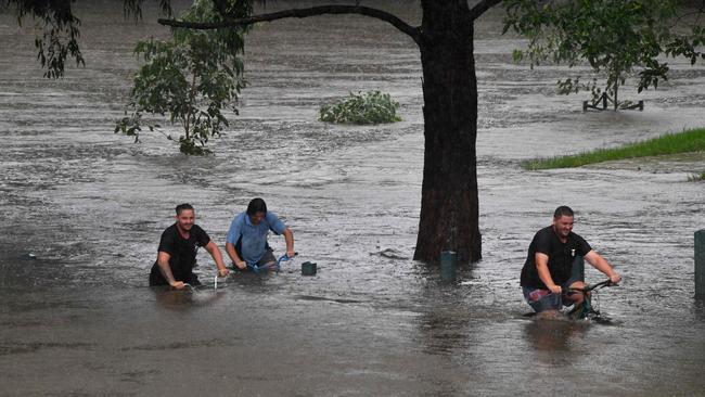
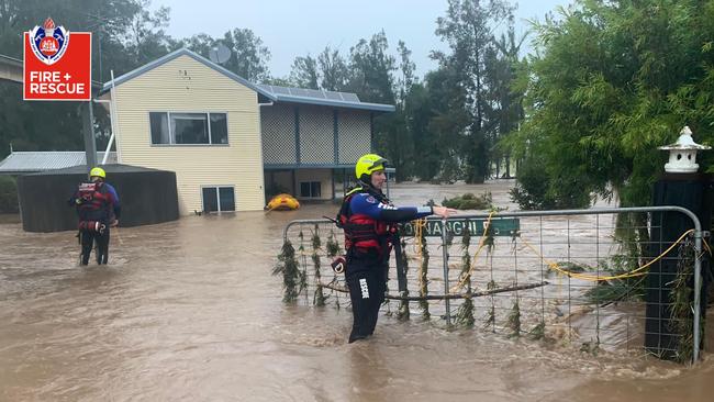
Rhiannon Down2.43pm:Emergency services undertake more than 600 rescues
Emergency services have conducted more than 670 rescues over the course of the NSW flood event, and received more than 6000 calls for assistance.
“NSW Rural Fire Service crews are assisting SES in a number of ways from clearing blocked drains to removing fallen trees and even flood rescue operations,” NSW Rural Fire Service said online.
#NSWRFS crews are assisting #NSWSES in a number of ways from clearing blocked drains to removing fallen trees and even flood rescue operations, as was undertaken yesterday in the Taree area. Stay safe and up to date by following @BOM_NSW and @NSWSES. (Video: Kathryn Elizabeth). pic.twitter.com/EFo3aokDXA
— NSW RFS (@NSWRFS) March 21, 2021
NSW SES commissioner Carlene York urged at-risk communities to prepare for the event of an evacuation, as parts of western Sydney faces imminent flooding.
“If they do get an evacuation (alert) we ask them to get ready,” she said.
“Get possessions up to a high level of the houses or sheds, pack an emergency kit with your valuables, your identity documents and things that you need to take just in case you are away for a number of days, and we will be letting them know where they can safely evacuate.”
“For information on the roads with accessibility and evacuation routes the Live Traffic (website) is always updating the information,” she said.
“And it does go down to the council roads, and gives more information for those more remote areas as well. So people can know what road is safe to travel.”
Our firefighters continue to work with @NSWSES and other emergency services during the extreme weather event in NSW. 300+ rescues performed by hundreds of firefighters in the past 48 hours including mass evacuations, water removal and retrieval of stranded people and pets. pic.twitter.com/GFnAP7zQnL
— Paul Baxter (@PaulBaxterFRNSW) March 21, 2021
Christine Kellett2.28pm:Landslides, floodwaters threaten infrastructure
Infrastructure is under major stress on the Mid North Coast as landslides pose a rising threat along with floodwaters.
Robert Scott, the director of infrastructure and engineering at the Mid North Coast Council, says the ground in some parts of the region is so saturated, it is now the consistency of yoghurt, posing a real threat of landslips and falling trees as the wind picks up.
He said the sewerage system in some parts was also inundated amd appealed to residents to exercise caution and only use what they needed.
“The drinking water is getting contaminated by the dirty water going down the river system, (so) the less water that we take the easier it is,” Mr Scott told the ABC
“Our sewer system is at a significant strain, the less will be put into them the better it is.
“We have had some fairly significant landslides in the upper rural areas, we also expect to see quite a few washouts, we have had a lot of homes and businesses inundated.
“The worst scenario would be if we see some predicted heavy winds coming to the area. We have absolutely water saturated ground, some areas are more like the consistency of yoghurts, so it is really dangerous conditions if people are out and about.”
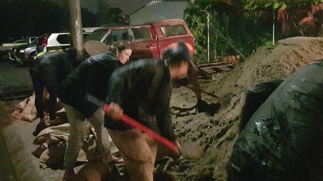
Rhiannon Down2.03pm:Communities band together
Communities smashed by floods and rain on the NSW Mid North Coast have banded together to sandbag shops and houses and provide support to those displaced by rising water.
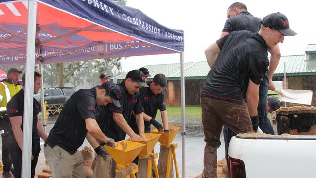
The Port Macquarie SES branch said locals who had arrived to collect sandbags on Saturday had picked up shovels and begun filling sandbags for the rest of the community.
“Pay it forward...Look at these legends,” a post on the unit’s social media said.
“Came to pick-up their own sandbags and started filling for others. Thank you so much for your support!”
Meanwhile, concerned community members raced to secure feed and rugs for evacuated livestock, with many turing to social media in an effort to secure supplies.
One social media user posted a plea for help from the Wauchope Showground, where more than 50 horses had been evacuated.
“If anyone in Wauchope has any kind of buckets or tubs that they could lend us at the showground it would so appreciated,” the poster said.
“We’ve got sooooooo many horses here that have been evacuated. We’ve run out of our … supply.”
Rhiannon Down1.39pm:Warragamba Dam water release wouldn’t have helped: Gladys
Gladys Berejiklian said the flooding situation in western Sydney may not have been helped by water releases from the Warragamba Dam.
The NSW Premier said some water had been released in the past month, but preparing for this level of rainfall would not have been possible.
“I’ve received advice some water has been released in the last month,
“But given the rainfall that we are experiencing in the next few days, you would have had to reduce the capacity of the dam to around 20 to 25 per cent, it just would not have been feasible,” Ms Berejiklian said.
“It is a one in a half century event. It is not just the dam, it is the rivers which are overflowing, it is sustained rainfall.
“[And] you have to look beyond the dam, it’s all the rivers that are overflowing, it’s the sustained rainfall, in very short periods of time it’s been bucketing down, and again it’s a front that’s not moving and locked in for a few days which we haven’t seen for half a a century.”
Rhiannon Down1.29pm:‘A fatality is getting more and more likely’: Emergency Minister
NSW Emergency Services Minister David Elliott has warned a fatality could be imminent as the situation worsens, while urging motorists not to put themselves at risk.
“This is the wrong time of the year to be taking any risks,” Mr Elliott said.
“I am horrified to think that there were unnecessary flood rescues going on.
“Of course there will be the inevitable, there are a number of houses that will just be surrounded by floodwaters and that will be necessary, the unnecessary risks that are being taken by these motorists is beginning to wear thin on the authorities.
“It is an offence, and I think people need to be reminded that inevitably, with the damage that has been done across the road network in this state, a fatality is getting more and more likely.”
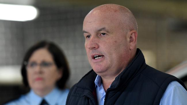
Mr Elliott said the declaration of a natural disaster across 16 local government areas meant impacted communities would be able to receive federal assistance.
“That includes low interest if not zero interest loans, people can get assistance to recover damages made to their homes,” he said.
“There are subsidies for the movement of freight in the event that livestock and agriculture needed to be moved around the stage.”
Rhiannon Down1.14pm:Floods a one in 100 year event: Premier
Gladys Berejiklian has described flooding on the NSW Mid North Coast as a one in 100 year event and western Sydney as a one in 50 year weather event.
The NSW Premier said authorities were closely watching the Hawkesbury River that was threatening western Sydney communities, including Penrith, with further evacuations imminent.
“The main focus today is of course the Richmond community, the Hawkesbury Valley community and parts of western Sydney. We weren’t envisaging a one in 50 year event yesterday - we were hoping it would only be a one in 20 year event. Now it looks like a one in 50 year event, and that means potentially another 4000 people may be asked to evacuate in and around that Hawkesbury region and parts of western Sydney
“We will know in the next few hours whether that is the case, and we will ask everybody do please keep watch on information and finally advise if you are to evacuate.”
“Regrettably, parts of the mid North Coast are experiencing a one in 100 year event, and while we don’t think things will worsen on the mid North Coast, definitely conditions will continue,” the Premier said.
Ms Berejiklian said 13 evacuation centres had been set up across the state including on the Mid North Coast, the Hunter Valley, and parts of the Richmond and Hawkesbury community.

Rhiannon Down12.50pm:Worst floods since 1961 expected: BOM
This weekend’s flooding event in NSW is expected to be the state’s worst since 1961, according to the Bureau of Meteorology.
BOM flood expert Justin Robinson said authorities were extremely concerned about flooding in the Nepean Valley, with water levels in Penrith rivalling the 1961 flood.
“It is bigger than the 1990 flood, and it is bigger than the 1964 flood. It is one of the biggest floods we are likely to see for a very long time,” he said.
“I know floodwater at Penrith is expected to then move downstream and impact those communities, at North Richmond, Windsor, Sackville, and further downstream.
“It is really important that community members listen very closely to the instructions from New South Wales about potential evacuations, they keep current with the bureaus flood warnings, our flood warning team is fully concentrated and updating those predictions for the Hawkesbury Nepean Valley today, providing updates every three hours, or more frequently as the situation changes.”
Climatologist Agata Imielska said the bureau was predicting conditions would worsen on Monday as new rainfall is set to cause rising water levels.
“Tomorrow we are expecting it to really intensify for that particular region,” she said.
“So be very mindful for the communities out there, you have already experienced very dangerous conditions, and they are going to be treacherous yet again, so keep a close eye on warnings, and again, expect those river rises and flood risk to continue.”
Nicholas Jensen12.37pm:Hundreds Stranded along the Pacific Highway
The Pacific Highway continues to be belted by torrential rain, with reports of more than 500 people stranded in cars and trucks unable to move south.
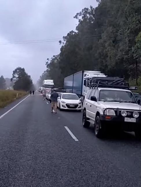
Dangerous flood waters emanating from the Manning River have caused road closures and major delays between Port Macquarie and Taree, with travelers now attempting to turn back to Port Macquarie.
NSW Police have informed travelers that the highway could be closed for up to four days until flooding subsidies and debris is removed.
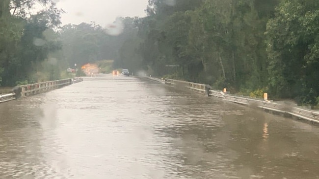
The Bureau of Meteorology (BOM) reports it will be closed until at least Tuesday, as conditions across the region remain volatile, with heavy rainfall still being recorded across Port Macquarie and the Taree regions.
Kylie Ann Diemar, who was travelling to Newcastle yesterday, was stranded along the highway overnight near the town of Moorland.
“We were stuck near Moorland with hundreds of cars and trucks banked up. We had no food, there’s no toilets. There is a small servo along the road, but nothing with food.”
“The rain is coming down in sheets… You didn’t dare sleep because of the heavy rain and the potential for trees to fall,” she said.
Ms Diemar returned to Port Macquarie this afternoon, but said she was concerned about others trying to make it through, as conditions continue to worsen.
Staff writers12.20pm:NSW Premier to give an update at 1pm
NSW Premier Gladys Berejiklian will be giving an update on the NSW floods along with NSW Police and Emergency Services Minister David Elliott and NSW State Emergency Service Commissioner Carlene York.
The Premier is due to speak at 1pm.

Rhiannon Down12.03pm:Flood fall out to extend past Easter: SES deputy commissioner
The State Emergency Service says authorities will be dealing with the fall out from the floods until past Easter, as a natural disaster is declared in parts of NSW.
NSW SES deputy commissioner Daniel Austin said the service had received thousands of calls for help, with the number rising rapidly.
“Overnight we saw just over another 750 calls come through,” he told ABC News Channel.
“It takes us well over the 4,500 mark since Thursday and with the expected continued rain, there’s certainly no sign of that letting up any time soon.”
Mr Austin said more than 1500 SES volunteers had been working in trying conditions to assist communities hardest hit by the floods, which includes western Sydney and the Mid North Coast, and were bracing for conditions to worsen.
“So we’re planning out from the perspective given that there’s also an inland trough coming, that will bring significant widespread rain across the inland parts of the state,” he said.
“We’re planning well beyond Easter for our own operations because, of course, just because the rain may stop on Thursday, the rivers naturally don’t go back to their normal state and then there’s going to be an extended recovery period post this given how widespread it has been.”
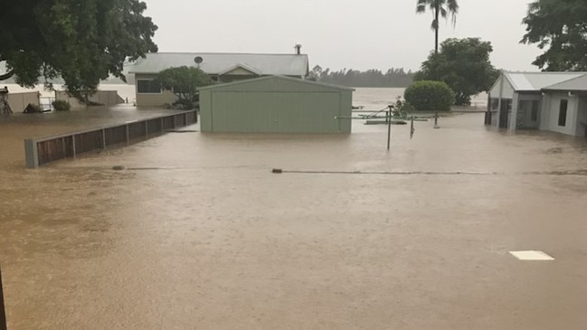
Nicholas Jensen11.43am:Mid North coast communities ‘cut-off, isolated’
Failing internet and communication problems continue to affect residents across the mid North Coast, as evacuation centres near the Manning River say they are “cut-off and isolated”.
Mayor of the MidCoast Council, David West said “it’s very difficult to get any information… we don’t have any internet and we’ve been told it’ll be off the map until Wednesday.”
“We have the largest flood plains in NSW... The impact is unbelievable and so widespread.”
President of the Wingham golf club, Peter Tate, who is managing the evacuation centre, said disruptions are affecting the flow of information and the centre’s ability to get quick updates.
“The system is not fit for purpose. And it just seems ridiculous in a country like Australia that we can’t communications right here.”
“They should’ve been fixed after the fires, but now it’s happening again.”
The Wingham evacuation centre was sheltering more than 100 residents yesterday afternoon, Mr Tate said, but locals have “rallied together and helped out”. The centre is now holding close to 50 residents.
Some of the images our 7NEWS cameraman shot as the Manning River flooded the Taree region today. https://t.co/zAoYmj1Ove#NSWfloods#7NEWSpic.twitter.com/fiCbuhAa0J
— 7NEWS Sydney (@7NewsSydney) March 20, 2021
While some of the worst conditions are subsiding, Mr Tate said there is still hazardous roads and dangerous flooding. “People still need to be vigilant… some roads have been swept away and there’s still threatening conditions out there.”
“The extent of the damage is not clear… most people still haven’t left evacuation centres because they can’t get back to their homes,” said Mr Tate.
Rhiannon Down11.35am:BOM warns conditions to worsen
Bureau of Meteorology senior meteorologist Jonathan How says authorities are bracing for conditions to worsen on NSW’s Mid North Coast, with more rain forecast for today.
“For the rest of Sunday, our concern is really going to be across the Mid North Coast where rain is really going to ramp up again this afternoon.,” he told ABC News Channel.
“And then we are also going to see heavy falls through Western Sydney and the Blue Mountains and down through the Illawarra as well.
“We are expecting generally 50-100mm, but some places could get as much as 200mm, and the weather warning has been extended, so it does reach all the way from Wollongong up to the Queensland border for heavy rainfall.”
Mr How said flooding on the Hawkesbury River has placed a number of communities at risk, including Richmond in Sydney’s North West.
“We are really going to see conditions dangerous across western parts of Sydney,” he said.
“We’ve seen the Hawkesbury River at Richmond tick over the major flood level and there is possible major flooding downstream.”
âš ï¸ Severe Weather Warning âš ï¸ for HEAVY RAINFALL and DAMAGING WINDS has been updated. Keep up to date with the latest forecasts and warnings over the coming days: https://t.co/HaDgXSP0Jbpic.twitter.com/3GzH223j85
— Bureau of Meteorology, New South Wales (@BOM_NSW) March 20, 2021
Rhiannon Down11.25am:Rescue in Port Macquarie
First responders braved a treacherous journey through flood water to rescue residents of a residential facility in Port Macquarie.
Rescuers waded three kilometres to evacuate residents, ferrying them in a boat borrowed from a local resident to safety.
“Strike Team Zulu waded and paddled 1.5km each way to ensure residents of a residential village in Port Macquarie could evacuate safely,” Fire and Rescue NSW said on social media.
Strike Team Zulu waded and paddled 1.5km each way to ensure residents of a residential village in Port Macquarie could evacuate safely. They were helped by a local who had access to a flat bottom boat, meaning we could transfer up to 12 people at a time. pic.twitter.com/KlqLAiBKn2
— Fire and Rescue NSW (@FRNSW) March 20, 2021
A flood warning was issued for low lying areas of Port Macquarie on Friday with heavy rain causing widespread flooding on Saturday.
Images showing streets and houses underwater have emerged from the coastal city, after high rainfall caused the Hastings River to burst its banks.
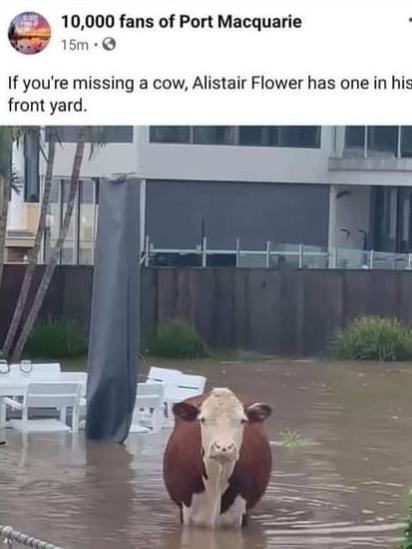
Me to Mum & Dad: oh wow, I’ve heard about the dreadful storms and flooding in the mid north of NSW. How’s the river next to your house?
— Jason Groves (@jasongroves) March 20, 2021
M&D: not too bad. A few things floated past and washed up on our lawn.
Me: what, like a few logs and trees?
M&D: Um.. #PortMacquarie#cowpic.twitter.com/TXRoXc6zH4
Staff writers11.00am:Natural disaster declared in parts of NSW
The state and federal government have declared a natural disaster amid widespread flooding on the Central, mid and north coast of NSW.
The natural disaster zone extends from the Coffs Harbour and Grafton area in northern NSW into the west to Cessnock and Dungog and up to the Central Coast.
Natural Disaster Declaration:
— Rotary Port Mac West (@RotaryPMQWest) March 20, 2021
Disaster Welfare Assistance Line 1800 018 444.
Concessional loan-NSW Rural Assistance Authority -1800 678 593 or https://t.co/isRHjm0LrT.
Australian Government’s Disaster Assist https://t.co/20hniUuNvBhttps://t.co/n6oD0uhca5#MidNorthCoastpic.twitter.com/Hoz7PRLqg0
Rhiannon Down10.45am:Wet week ahead for NSW
Rain soaked NSW has little respite on the horizon, with rain forecast almost every day for the coming week.
A second wet weather event was expected to arrive early next week following a once-in-100-year event over the weekend, according to the Bureau of Meteorology.
Sydney was predicted to receive between 25 to 50mm on Monday and 35 to 50mm on Tuesday, with showers predicted to make a return on Thursday and Friday.
Meanwhile, Port Macquarie on the Mid North Coast,which has been hit hardest by the floods this weekend, has more than a 90 per cent chance of rain on Monday and Tuesday and up to 50mm predicted.
Senior forecaster Neale Fraser said the outlooked remained wet and gloomy for much of the state over the coming days.
“Another rain band will come in from central parts of the country on Monday and Tuesday so we’re expecting further rain inland not just coastal areas early next week,” he said.
He said a weather system was acting like a “conveyor belt” moving moisture bringing a drenching to much of inland Australia, including the NT, over the coming days.
“Satellite photos show there is lots of weather activity north west of WA and cloud bands across the country,” he said.
Rhiannon Down10.15amSES continues to issue evacuation orders
NSW authorities continue to issue evacuation orders and flood warnings, as the state continues to be battered by a wet weather event.
The SES has urged residents in low lying areas on the Hawkesbury River, North Richmond and Pitt Town North to evacuate their homes this morning, as water levels rise dangerously high.
On Saturday, it issued similar warnings for Central Wingham, Taree Estate, Dumaresq Island and Cundletown, low lying areas of Laurieton and North Haven and Dunbogan and low lying properties of Bulahdelah, among many other locations.
It’s not looking good here at Hinton, this entire street near the Paterson river is underwater. Rain still coming down hard in the Hunter. #NSWFloodspic.twitter.com/NuZvo9fYT3
— Bindi Bryce (@BindiBryce) March 20, 2021
Flood warnings have also been issued for Bowraville, Macksville, the Camden Haven River at Logans Crossing and the Myall River, all on the mid north coast.
It follows dozens of flood warnings and flood watch alerts being issued over the last 24 hours, including major warnings for the Gloucester, Manning, Nepean and Colo Rivers.
Staff writers10.10am:QLD Premier sends help to NSW
Queensland Premier Annastacia Palaszczuk has sent out a tweet to confirm her state would be sending support to NSW to assist with the severe weather event.
Queensland’s resources being sent down includes 10 SES flood boats and 40 crews, as well as specialist operators and management teams.
We’re sending help to New South Wales, including 10 SES flood boats and 40 crew.
— Annastacia Palaszczuk (@AnnastaciaMP) March 20, 2021
We’re also sending swift water rescue resources and crews, drones and operators to do rapid damage assessments, and incident management teams.
Rhiannon Down9.55am:Police stretched: Missing bodyboarder, Woollahra homes evacuated
Police and emergency services were inundated with requests for assistance, as NSW was battered by catastrophic rain on Sunday.
Two bushwalkers became stranded in the Blue Mountains while hiking the Six-Foot Track at Katoomba after rising water levels cut them off, and had to be rescued by Blue Mountains Police Rescue.
Four houses on Wallaroy Crescent in Woollahra in Sydney’s East were evacuated after a 40m natural rock wall began to collapse, threatening nearby homes.
A concerned resident alerted emergency services after the wall began to shift in the downpour, at about 8.30pm.
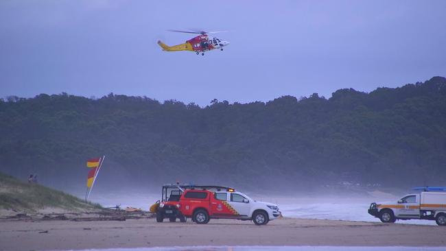
Meanwhile, emergency services have resumed their search this morning for a missing bodyboarder in Coffs Harbour.
The alarm was sounded after the male bodyboarder failed to resurface at North Wall Beach at about 2.25pm on Saturday, but rescuers were unable to locate him.
Nicholas Jensen9.30am:Wild weather to affect vaccine roll-out
The federal government says NSW’s unfolding weather emergency will delay Monday’s planned rollout of the coronavirus vaccine.
The Department of Health has warned flash flooding would delay the distribution of vaccines across the state, with regional NSW particularly affected.
A spokeswoman for the government said: “Vaccines are being delivered across the country and will be in place in most locations by the end of the weekend.”
However, due to the extreme weather conditions and flooding in many parts of the state, “vaccine delivery is being affected in Sydney and across multiple regional NSW locations.”
“The Department of Health is working directly with GPs on these issues and we ask for the public’s patience with these unforeseen supply delays.”
Phase 1b of the vaccine rollout is set to begin on Monday, with the first locally produced shipment of AstraZeneca expected to be delivered across the country at the beginning of next week.
Health officials have said they will provide an update tomorrow concerning which areas will be particularly affected.
Christine Kellett9.05am:Sydney’s outskirts in ‘uncharted territory’
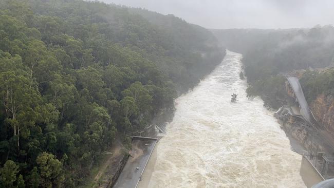
Parts of urban NSW are in “uncharted territory” following the spillover of Sydney’s Warragamba Dam for the first time in five years.
The Dam began to overflow about 4pm yesterday, an event not seen since 2016.
Ian Wright, a water scientist at the University of Western Sydney, said development of the urban landscape made many more population centres prone to flooding in weather events such as the one currently unfolding.
“The whole landscape is changing. The northwest part of Sydney is expanding quickly. There’s a lot of urban development, commercial development, and the southwest and north west, enhanced with the new aerotropolis, the new airport,” Mr Wright said.
“We have seen a lot new people coming into western Sydney, it’s a major economy, both for jobs and residents. There’s a lot of people also living that don’t have any memory of flood.
“We have had an enormous transformation in the Hawkesbury Valley from essentially semirural landscape to an urban landscape and that has brought a lot more people basically into flood-prone land, and at the same time all the hard surfaces and pipes and plumbing, that changes the way that water has flowed and that has created much more potential for flash flooding and contributing to regional flooding. So we’re in a landscape now, this is uncharted territory, we got a lot more people living in a highly flood-prone area.”
Christine Kellett8.25am:SES responds to thousands of calls
The NSW State Emergency Service continues to be inundated with calls for help, responding to 750 jobs overnight.
SES Deputy Commissioner Daniel Austin said the agency had been kept busy responding to downed trees, car crashes and rescues, clearing debris and sandbagging.
“We saw a mini-tornado through parts of the Sydney metro area yesterday and obviously a very significant amount of flood-related calls right up and down that coastal strip,” Mr Austin said.
“One of the concerns for us is that whilst a couple of areas have seen some receding flood waters overnight into this morning, that heavy rainfall returning to those locations today will likely lead to additional peaks on those river systems and then potentially we may even see that again tomorrow and the day after. So we’re planning out from our perspective given that there’s also an inland trough coming, that will bring significant widespread rain across the inland parts of the state. We’re planning well beyond Easter for our own operations because, of course, just because the rain may stop on Thursday, the rivers naturally don’t go back to their normal state and then there’s going to be an extended recovery period post this given how widespread it has been.”
He said the SES had responded to 4,500 calls for help since rain began falling on Thursday.
#Taree and the #ManningValley is a massive disaster zone, people are trapped in their homes, they’re calling for assistance & no help arrives so they’re asking for help on social media. @NSWSES appears to be under resourced & under prepared .../1 #midnorthcoastfloods#NSWFloodspic.twitter.com/YY5txw3d6q
— Val Schaefer (@schaefer_val) March 20, 2021
Christine Kellett7.55am:‘Another big weather event coming’
A tropical storm system affecting the Northern Territory today will push south into NSW by early next week, extending the weather emergency battering the state.
The low pressure system could bring heavy weather to parts of inland NSW by Monday night.
“For the next 48 hours at least, we are expecting the steady rainfall with pockets of heavy falls as well for the Mid North Coast and through the Blue Mountains, but there is another big event coming from the tropical north,“ BoM senior forecaster Jonathan Low has told the ABC.
The craziness of Sydney’s weather #rain#sydneyweatherpic.twitter.com/j6HkWqePEg
— Daniel Nguyen (@_dn96_) March 20, 2021
“We are already seeing some warnings across southern parts of the Northern Territory this morning and we’re going to see some light rain moving to north western parts of
New South Wales, out towards about Bourke this afternoon, and really ramping up into tomorrow. Because there’s some pretty good thunderstorms across northern inland parts. Places like Nyngan and up towards the Queensland border. And that will combine and we could see an explosion of rain and thunderstorms across eastern New South Wales again, late into Monday and more likely into Tuesday.”
“And it will even spread into eastern parts of Victoria as well through Tuesday. So we aren’t going to see any easing until probably Wednesday, and rivers could flow quite high into that next week as well. So more dangerous weather to come.”
Christine Kellett7.30am:100mm falls over Sydney’s CBD
BoM says 100mm of rain has fallen over Sydney’s CBD overnight, with suburbs on the western outskirts also copping it.
Picton and Oakdale received about 160mm, while 100mm also fell over Homebush and Marrickville, BoM’s Jonathan How has told the ABC.
About 120mm also fell over the Warragamba Dam — Sydney’s main water catchment — which began spilling over yesterday for the first time in five years.
“It does reach all the way from Wollongong up to the Queensland border for heavy rainfall,” Mr How said.
Rozelle rapids! #sydneyweatherpic.twitter.com/2pt2rbDTaY
— Becca Leaver (@becca_leaver) March 20, 2021
“We are really going to see conditions dangerous across western parts of Sydney. We’ve seen the Hawkesbury River at Richmond tick over the major flood level and there is possible major flooding downstream. We have major flooding across the Gloucester and Manning River. Catchments are so saturated and any other rainfall that falls basically becomes and goes straight into the river systems.”
Not everyone unhappy with the rain! #sydneyweather#northcurlcurl#grommetspic.twitter.com/AurfEfAmMU
— katiewebb (@katiewebb) March 20, 2021
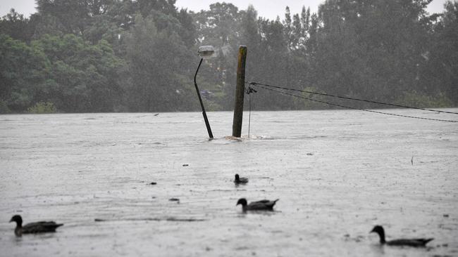
Christine Kellett7am:Evacuation warning for Sydney’s south west
The state SES has issued an evacuation warning for Picton, 80 kilometres south west of Sydney ahead of flooding.
The suburb recorded 160mm of rain overnight, according to the Bureau of Meteorolgy.
“The NSW SES is advising people in Picton CBD to prepare to evacuate,” the SES states.
“As a result of rising flood waters people within the Picton CBD should prepare to evacuate.
Residents should monitor the situation and be prepared to evacuate when instructed to do so.”
🔴Multiple #Evacuation Orders have been issued in Western #Sydney area, take action now and read all Evacuation Orders @NSWSEShttps://t.co/t578A4Mkg8
— NSW SES (@NSWSES) March 20, 2021
🟢For emergency help in floods and storms, call the NSW SES on 132 500. In life threatening situations call triple zero (000). pic.twitter.com/GUfkgP2o6O
It follows evacuation warnings for the Richmond area, north west of Sydney about 2.30am, where rising waters from the Hawkesbury-Nepean rivers are expected to impact residents.
Nicholas Jensen6.45am:Warragamba Dam spills over
Sydney’s main water source, the Warragamba Dam, is overflowing as heavy rainfall continues to lash Sydney and the outer west.
Bureau of Meteorology’s (BOM) Flood Operations Manager Justin Robinson said “the exact timing of the flooding depends on which areas of the catchment receive the heaviest rainfall and the time in which they receive that rainfall,” he said.
According to the BOM, the dam had already reached 99.2 per cent capacity by Saturday afternoon.
More video of #WarragambaDam spilling. pic.twitter.com/YYBlrmTnV4
— Benjamin Ansell (@averagejourno) March 20, 2021
Spill from the dam is expected to combine with river flows from the Upper Nepean and the Grose River, as well as other local tributaries, including South Creek.
NSW Premier Gladys Berejiklian said emergency services were preparing for either “a one-in-five, one-in-10 or one-in-20 year event”.
She has urged residents in the catchment area to be on high alert in case they were required to evacuate.
Christine Kellett6.30am:Severe weather, flooding danger for Sydney and regions
People in several low-lying areas along the NSW coast have been urged to evacuate as record-breaking rains and raging floodwaters threaten homes and lives.
A severe weather warning remains in place on Sunday from Lismore to the Illawarra, the Hunter Valley, Snowy Mountains, the ACT and even as far south as Wagga Wagga.
BoM is also warning of hazardous surf and the potential for major flooding from the Mid North coast to Sydney and the south coast, with authorities are urging all residents in high flood zones to prepare for the possibility of evacuation.
The State Emergency Services expects flooding in the Sydney region’s of Penrith and Richmond.
âš ï¸ #Flood Warning updated for the #Hawkesbury#Nepean and #Colo Rivers. #Major flooding occurring at #NorthRichmond. See https://t.co/PhlmnxmE6v for details and updates; follow advice from @NSWSES. #NSWFloodspic.twitter.com/AIVpubi41v
— Bureau of Meteorology, New South Wales (@BOM_NSW) March 20, 2021
NSW Premier Gladys Berejiklian on Saturday said “it will not be an easy week” for the state, with the onslaught of wet weather expected for the most part of the week to come.
“I hate to say this again to all our citizens of the state but it’s not going to be an easy week for us, but I know no matter what comes our way we will be able to deal with it,” Ms Berejiklian said
“Unfortunately this will be a deep-seated, extreme weather event.
“The rain may not stop till Thursday or Friday.”
🌧ï¸#Rain continues to affect eastern #NSW. Highest totals 9am Sat to 4am Sun include:
— Bureau of Meteorology, New South Wales (@BOM_NSW) March 20, 2021
- Stone Quarry Ck Picton 159mm
- Oakdale 139mm
- Warragamba 120mm
- Erina Heights 119mm
Stay up to date with the latest info & warnings at https://t.co/IVplABUDsD and follow advice from @NSWSESpic.twitter.com/dRwLMpxnCd
Dan Mills6am:Bride-to-be tells of watching house wash away
A shocked bride-to-be has recounted the moment she and her fiancee were forced to call off their wedding on Saturday when she saw their house crumbling into the Manning River at Mondrook, near Taree.
Sarah Soars, 24, and Joshua Edge, 26, were dealt the cruellest of blows when floodwaters savaged their Mondrook rental, and washed it away downstream.
A shattered Sarah Soars told The Mid-North Coast News that she couldn’t believe her eyes when from a lookout — high above the Manning River — she spotted the house and all their possessions capsizing into the water about 9.30am.
I was up at the lookout at Taree West near where my younger sister lives for maybe 15 minutes before it started to move … I thought, ‘Oh no, this can’t be happening’.”
“Next minute, the house was gone.”
Incredible, but devastating footage of a house floating down the Manning River at Taree.🎥Tanya Cross #NSWfloodspic.twitter.com/KTggPpvlWO
— Claudia Jambor (@claudiajambor) March 20, 2021
It was the start of the end of her massive plans. Ms Soars was to marry her fiance Joshua Edge in front of 60 family and friends at Mondrook Hall.
She said more than $100,000 worth of prized possessions are now gone, either floating somewhere along the Manning River, out at sea or sitting in floodwaters at home.
“Someone has found my partner’s big wooden chest, though, which washed up somewhere with a bunch of valuables in it,” she said.
“But we’ll have to start again with everything, even our clothes.”
Mr Edge described the moment when his wife-to-be - who was separated from him by the flood waters - called him in horror to tell him their house had been taken by the floods.
“Watching our house just go past us, it is not our house, our home go past, it was devastating,” he said.
“Yeah. We lost everything. Our little dog was in the house. Like, there was no warning. There was a warning but no-one expected it to be this bad.”
A GoFundMe page has been set up to support the couple, who lived in the home.
More than $33,000 has been donated so far. To contribute click here.
Additional reporting Rhiannon Down
Add your comment to this story

‘Archaic’: US welcomes end to beef restrictions, blasts biosecurity rules
US meat exporters say Australia’s decision to end limits on American beef is ‘long overdue’, arguing local biosecurity rules don’t appear to be consistent with the principles of free trade.

Top British officials touching down to touch base
AUKUS will be the focus of talks between UK and Australian ministers including British Foreign Secretary David Lammy and Defence Secretary John Healey, in Sydney on Friday.
To join the conversation, please log in. Don't have an account? Register
Join the conversation, you are commenting as Logout