NSW, Queensland floods crisis live updates: Evacuation warning issued for Sydney suburbs along Hawkesbury River
Fears of new flooding on the NSW mid-north coast have prompted the SES to urge residents to leave; Warnings issued from Qld to Victoria and parts of Tasmania.
- 18,000 displaced, helicopter supply drops planned
- Evacuation warning for Sydney suburbs
- ‘Life-threatening’ rain hits Queensland
- Colo River residents evacuated
Welcome to live updates in Australia’s floods crisis.
More than 18,0000 people have been displaced, and there are fresh evacuation warnings and helicopter supply drops are planned amid major flooding from Queensland to Victoria.
Residents along the Hawkesbury River have been told to prepare to evacuate, while ‘life-threatening’ rain hits Queensland. Meanwhile Colo River residents are being taken from their homes by helicopter or boat, as defence force aircraft head to the NSW south coast.
Stephen Rice10.45pm: Dangers remain as wild weather begins to ebb
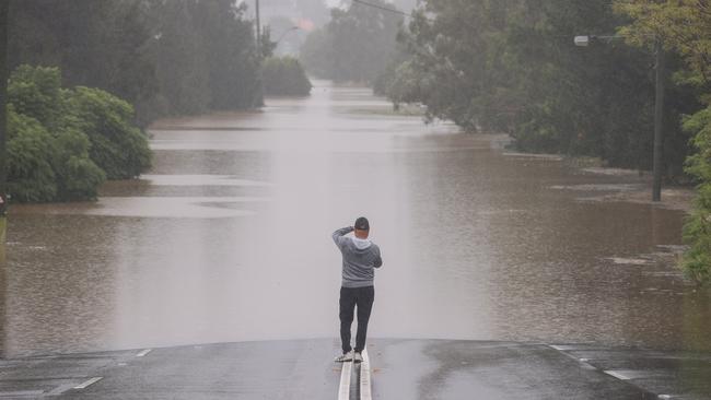
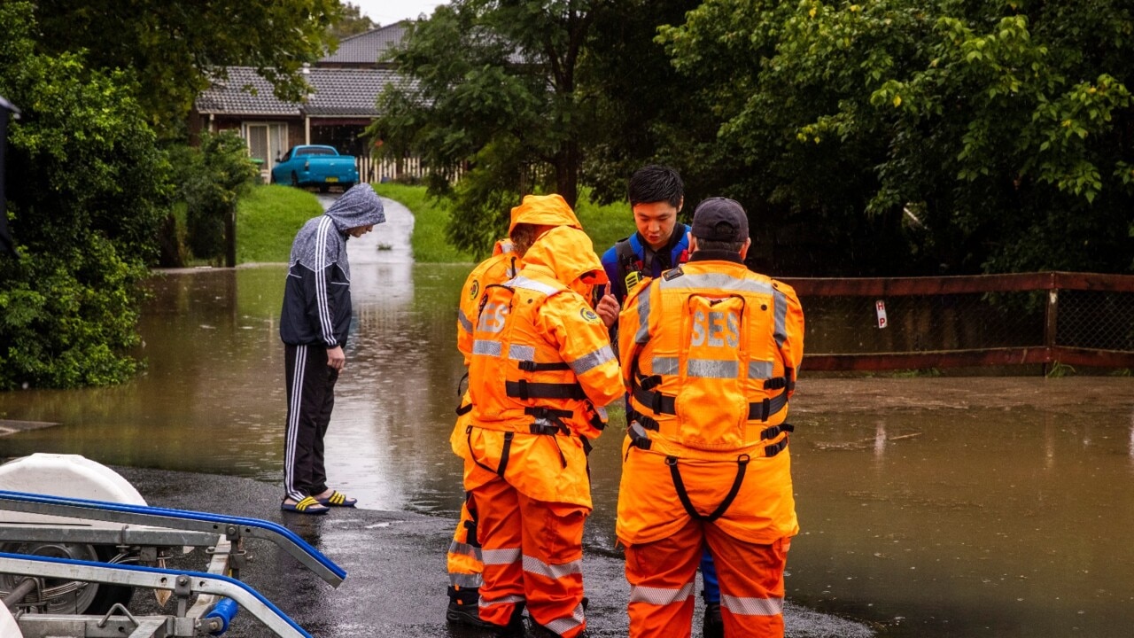
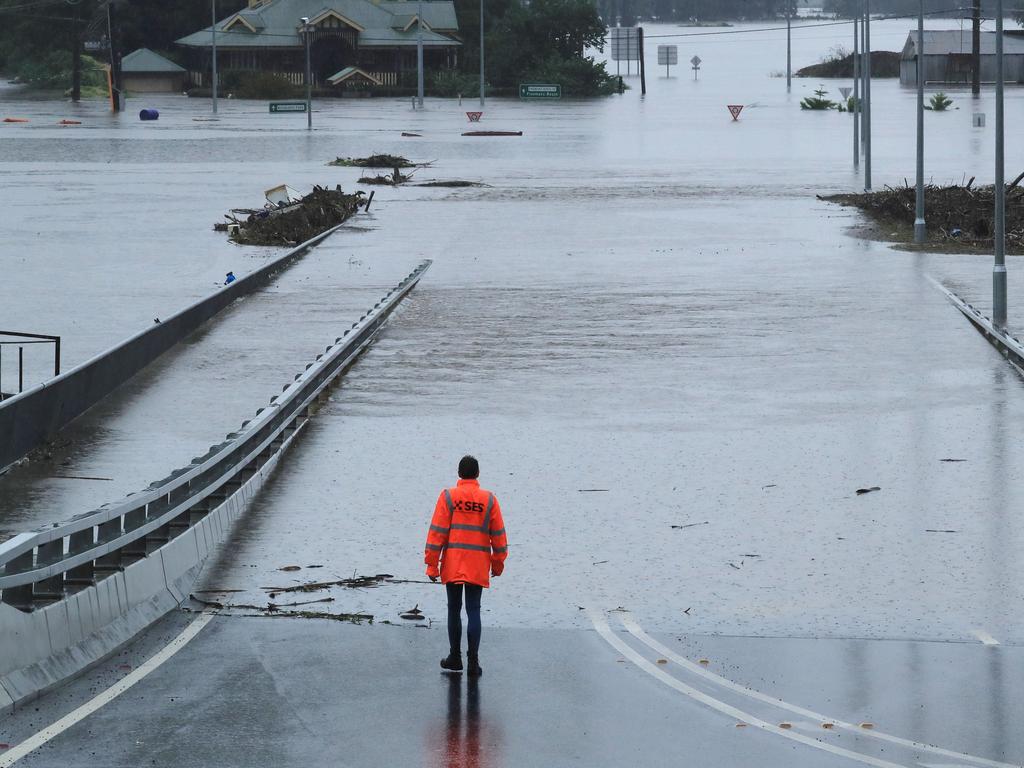
Exhausted emergency workers performed up to 1000 rescues and 15,000 evacuations on Tuesday as torrential rain inundated large parts of the east coast.
However, relief may be in sight with the wild weather system that wreaked havoc across the NSW mid-north coast and western Sydney beginning to ebb as it moved south to Victoria.
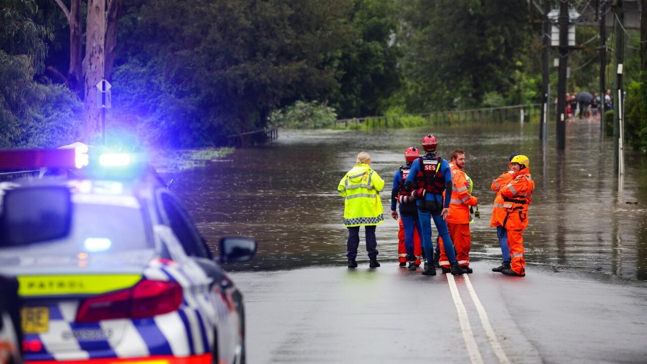
State Emergency Service volunteers and Marine Rescue NSW were forced to save a family of four twice on Tuesday when they were plucked from floodwaters at Upper Colo on the Hawkesbury River. The original evacuation craft capsized in rough water as they were being taken from their flood-bound home, forcing a second rescue.
Stephen Rice 10pm:Cabinet eyed proposal to reduce dam level
The NSW government last month considered lowering the amount of water in Warragamba Dam in a bid to save up to 1800 homes in the event of an overflow, confidential cabinet documents show.
The secret cabinet submission raises questions about the government’s claims the dam’s operating rules prevented it from being used for flood mitigation.
The submission, prepared for Water Minister Melinda Pavey and Western Sydney Minister Stuart Ayres and dated February 12, favours lowering the dam water level to 5m below full.
Joseph Lam9.15pm:School closures reach 280
At least 280 NSW schools have closed amid the flood crisis, including 212 public schools and 68 non-government schools
“Repairs and clean-up will begin where possible to ensure that schools can be returned to normal operations as soon as possible,” a NSW Department of Education spokesman told news.com.au.
“Local flooding and road closures are limiting access to some areas so it may take some days to fully assess any damage to some schools.
“We are continuing to work closely with emergency services to ensure our school communities remain safe and fully informed about any disruption to schooling this week.
“Before leaving home, parents and carers should consider their local situation including any existing road closures, transport disruptions and forecast weather conditions.”

Rhiannon Down 9pm:Flood risk remains as BOM predicts clear skies ahead
A rainband that has wreaked havoc across NSW over four day in a once in 50 years flooding event is predicted to clear on Wednesday and move south to Victoria, although the flood risk will remain for several days.
The Bureau of Meteorology has warned that despite the predictions for clear skies, high water levels in swollen rivers means flooding was likely to continue for the rest of the week across the Sydney basin and mid-north coast.
NSW was battered by another day of relentless rainfall on Tuesday after two weather events merged over the state, bringing weekly rainfall totals close to 1m in many locations on the mid-north coast, about two-thirds of the average annual rainfall.
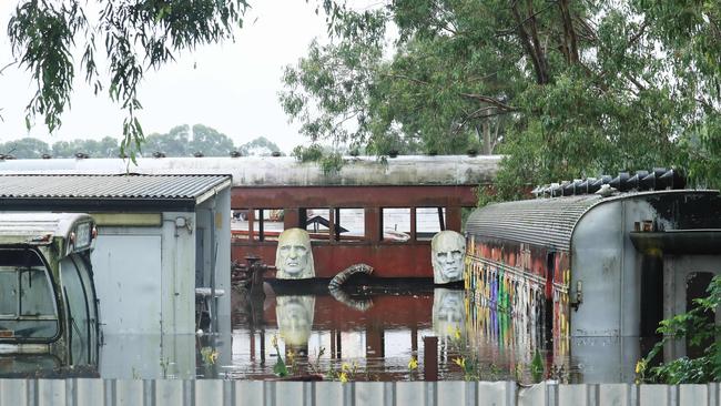
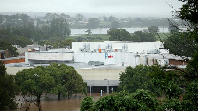
Kieran Gair8.40pm:Collectors’ haven swallowed by the river
It was a collector’s haven, a perennial curiosity for passing tourists, and a magnet for “pickers” from around the country — before it was swallowed by the Hawkesbury River.
The Junk Yard in Sydney’s flood-hit northwest, owned by self-described “bargain hunter” Gary Evans, has for decades attracted eccentric visitors hoping to find a diamond in the rough.
“There’s a lot of history in that place, you’ve got no idea,” the 73-year-old said, as he steered a small boat around a submerged steam train built in 1900. “I worked in demolition in Sydney for 40 years. I collected history, but this damage is unbelievable. I’ve probably lost about $200,000.”
Joseph Lam8.10pm: Pain set to ease for hard-hit areas
Some of NSW’s hardest-hit communities will be given respite after days of suffering, says the Bureau of Meteorology.
“After days of heavy rain we’re finally seeing it start to ease,” BOM said.
“While it’s some good news for hard hit communities, it’s not the end of the story.”
“Many areas are still facing significant flood risk, and in some communities waters are yet to peak.”
The news arrives shortly after BOM cleared its severe thunderstorms warnings in NSW and the ACT.
After days of heavy #rain we're finally seeing it start to ease. While it's some good news for hard hit communities, it's not the end of the story. Many areas are still facing significant #flood risk, and in some communities waters are yet to peak https://t.co/3h6w40u6RH@NSWSESpic.twitter.com/Bt4WZIrRN0
— Bureau of Meteorology, New South Wales (@BOM_NSW) March 23, 2021
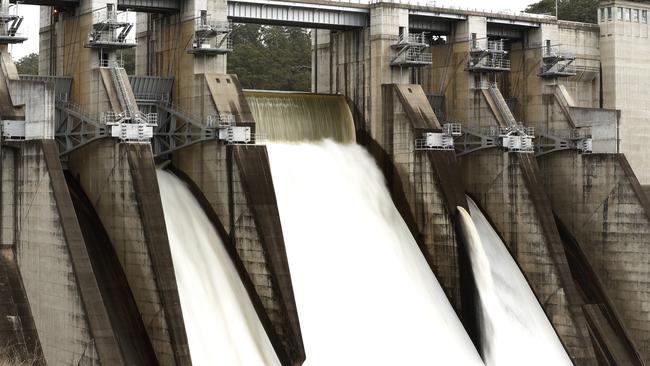
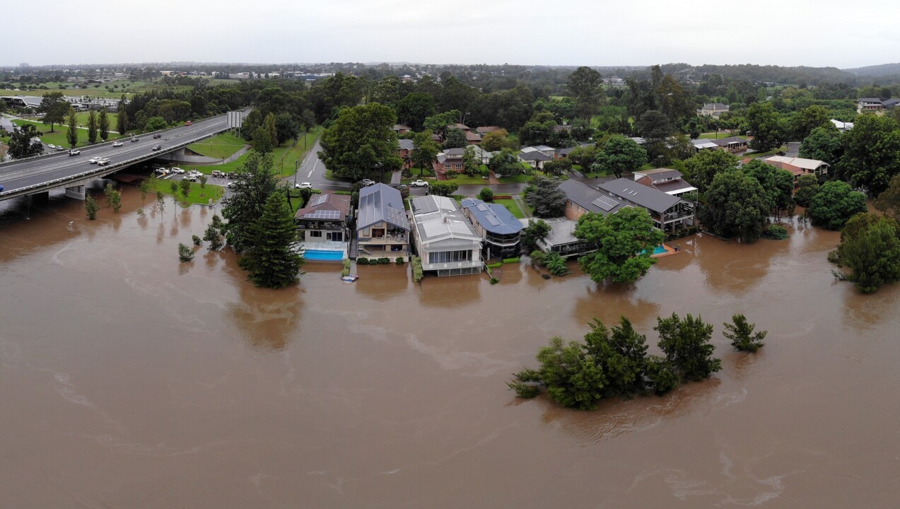
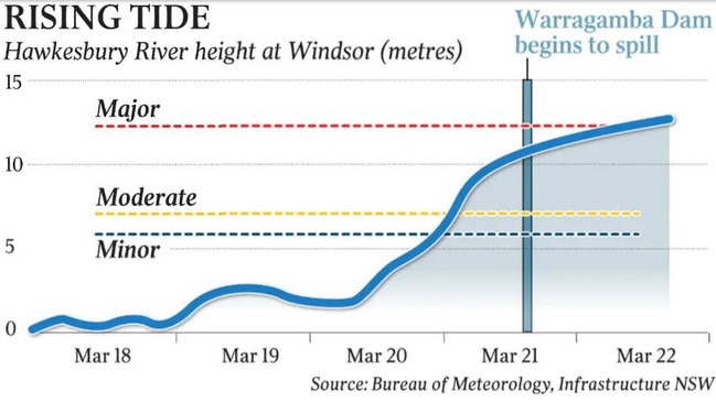
David Tanner 8pm:Dam not to blame for this latest inundation
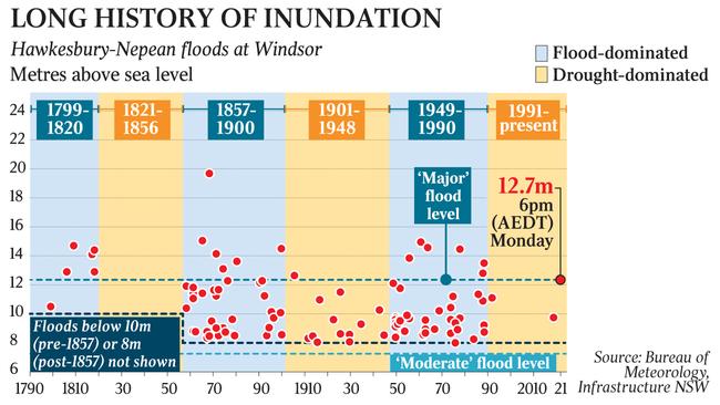
Warragamba Dam did not cause the flood engulfing communities in the Hawkesbury-Nepean Valley west of Sydney. An east coast low pressure system that dumped more than half a year’s worth of rain in six days did.
The Hawkesbury River at Windsor had already reached a height of 11m, about 1m below “major flood” level, before Warragamba started spilling on Sunday. The river has since risen to about 12.5m, where it has stabilised for the past 36 hours.
The largest recorded flood at Windsor — in 1867, almost 100 years before the Warragamba Dam was completed — exceeded 19m. So widespread was the flooding that parts of Blacktown were underwater.
Records show that the Hawkesbury River flooded just as regularly before the dam was built as since its opening in 1960.
Joseph Lam7.40pm: Northern NSW residents urged to leave
Emergency services have urged residents of Southgate, near Grafton in northern NSW, to leave now or face being cut off from rising flood waters and unable to be rescued.
State Emergency Services issued the direction to residents of low-lying areas in Southgate about about 6pm on Tuesday.
“Once floodwater passes 5.4 metres on the Grafton gauge roads in and around Southgate will begin to close and properties may become inundated,” SES said.
“If you remain in the area you will be trapped and it may be too dangerous for SES to rescue you.”
Staff Reporters7pm:New flood warnings issued for Hawkesbury River
âš FLOOD EVACUATION WARNING LOW LYING AREAS DOWNSTREAM OF SINGLETON âš The Hunter River at Singleton is likely to reach the moderate flood level of 11.50 metres overnight Tuesday into Wednesday. MORE:https://t.co/BCnxAe6tsR
— NSW SES (@NSWSES) March 23, 2021
âš MAJOR #FLOOD WARNING FOR HAWKESBURY RIVER AT WINDSOR AND SACKVILLE AREASâš Major flooding is occurring along the Hawkesbury River with major flooding expected at Wisemans Ferry in the next few hours.MORE:https://t.co/BCnxAe6tsR
— NSW SES (@NSWSES) March 23, 2021
Staff Reporters6.15pm:Residents in NSW town told: Get out
Residents of low-lying areas in Southgate, near Grafton, have been ordered to evacuate by 8pm tonight.
Major flooding is expected along the Clarence River.
“Once floodwater passes 5.4 metres on the Grafton gauge roads in and around Southgate will begin to close and properties may become inundated,” NSW SES says.
“Once floodwater begins inundating the area, road access, water, sewerage, power, phones and internet may be lost. If you remain in the area you will be trapped and it may be too dangerous for SES to rescue you.”
People are urged to stay with family and friends if possible. An evacuation centre is open at South Grafton High School on Tyson Street.
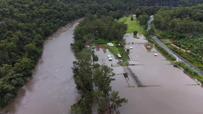
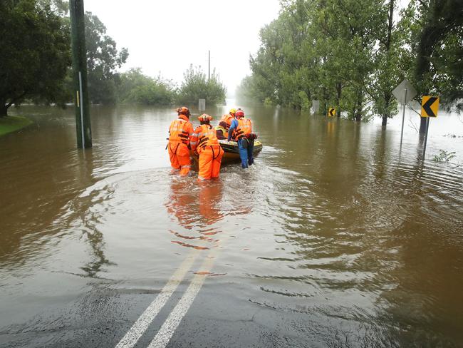
Joseph Lam 5.35pm:Relief: boats, chopper evacuations called off at Colo
Helicopters and boat evacuations on the Colo River have ceased after the State Emergency Service relieved the river of its evacuation orders.
An evacuation order was issued at 7.05am on Tuesday for the Colo River and Upper Colo in the Hawkesbury, on Sydney’s outskirts.
That order has since been downgraded and SES said the threat level to the community has now reduced.
“The Colo River at Upper Colo is currently peaking at 14.62 metres and not currently expected to rise any further. Due to this reduced threat to community, NSW SES has suspended helicopter and boat evacuations,” SES said.
SES reminded residents to remain vigilant and be prepared to evacuate in case conditions change.
Joseph Lam 4.45pm:Moree braces for major flooding, evacuation warning
Residents of Moree in northern NSW are braced for heavy flooding on Wednesday, with those living in low-lying areas warned of possible evacuations after the Bureau of Meteorology predicted major flooding.
The NSW State Emergency Service says the town is likely to be hit with major flooding after heavy rainfall over the past 36 hours raised water levels in the Horton river, within the Murray-Darling basin.
A major flood is likely to occur on Wednesday, with other locations along the Gwydir River at Gravesend and Yetman also likely to experience major flooding, SES said.
Moderate level flooding is expected at Pallamallawa.
State Emergency Services said major flooding is also possible at the Mehi River. also west of Coffs Harbour.
âš MAJOR #FLOOD FOR GWYDIR & MEHI RIVERSâš
— NSW SES (@NSWSES) March 23, 2021
Major flooding is likely Moree. MORE:https://t.co/BCnxAe6tsR
Cliona O’Dowd 4.25pm:Insurers hit with 12,000 flood claims
The nation’s insurers have received close to 12,000 claims following the record-breaking rains and devastating floods in NSW, with many more to follow.
The nation’s insurers have received close to 12,000 claims following the record-breaking rains and devastating floods in NSW, with “a large number more” expected in the coming days.
Most of the claims received to date are from the NSW mid-north coast towns of Port Macquarie, Kempsey, Laurieton, and Taree, and west of Sydney around Penrith and in the Hawkesbury-Nepean valley, the Insurance Council of Australia said on Tuesday.
“This remains an active natural disaster and it will take some time to gain a clearer picture of the damage,” Insurance Council chief executive Andrew Hall said.
“Insurers expect a large number of claims will be lodged in coming days as property owners begin returning to homes and businesses.”
While too early to estimate the cost of the damage, the ICA gave the February 2020 east coast storms and flooding event as a point of comparison. Insurers paid out close to $1bn in relation to that event.
Analysts have already warned that claims from the latest NSW and Queensland floods could eclipse last year’s $2bn bushfire payouts.
READ the full story here.
Joseph Lam3.45pm:Victorians dig in to help with NSW floods
At least 40 emergency personnel from Victoria have deployed to NSW as the state battles one of its worst floods in several decades.
The Victorian Country Fire Association sent 14 personnel to Sydney overnight alongside members of the Victorian State Emergency Services. Other members travelled to the state over the weekend.
VICSES has sent a total of 24 members to NSW, many of whom flew into the state over the weekend and to work out of the NSW SES Headquarters in Wollongong.
CFA state duty officer Peter Baker said his association was happy to help and expected more requests to come from NSW.
“The situation in New South Wales has been declared a natural disaster, and when we receive a call for assistance, we do what we can to help out,” said Mr Baker.
“I acknowledge the work done by every agency at every level to help co-ordinate this deployment. CFA is proud to be part of Victoria’s emergency services working as one.”

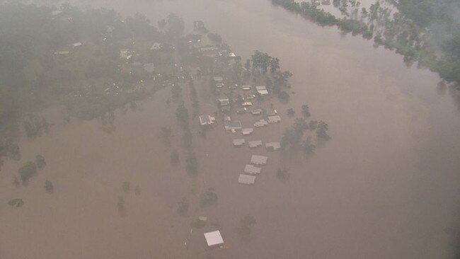
Debbie Schipp3.15pm:More than 18,000 displaced, supply drops planned
More than 18,0000 people have been displaced by flooding from Queensland to Victoria, Minister for agriculture, drought and emergency management David Littleproud has told parliamentary Question Time.
Residents along the Hawkesbury River at Windsor are stranded, Picton has been told to be ready to evacuate and helicopter drops are planned as flood levels across NSW worsen.
Mr Little proud said there have been over 850 rescues and 9500 calls for help as the heavy rains continue.
He announced that supermarket giant Coles is preparing to airlift goods as early as this afternoon into the North Richmond store in eastern Sydney to ease supply shortages.
“I’ve initiated national co-ordination mechanism as a result of feedback from senator Payne and the member for Macquarie around shortages in supermarkets in western Sydney and I can advise the house, I have only just been advised by Coles, that they intend to helicopter goods into North Richmond’s store this afternoon, as soon as arrangements can be made we will continue to make sure that mechanism is worked through in every community where there are shortages, where we are unable to get trucks or boats across to support these communities in their hour of need,” he said.
“We are also working with NBN and Telstra to make sure they are ready to pivot into these communities where telecommunications have been brought down so we can restore them as quickly as we can.”
The NSW SES has issued a flurry of updated alerts in the past hour.
An evacuation warnings have also been issued for the Picton CBD, with the SES advising people to prepare for a potential evacuation order.
That warning comes on top of earlier warnings for residents along the Hawkesbury from Wiseman’s Ferry, as well as for caravan parks along the Hawkesbury from Windsor.
Major flood warnings have been issued at Coutts Crossing on Orara River near Coffs Harbour, on the Hawkesbury at Windsor and Sackville, for Clarence River at Grafton, Maclean and Ulmarra, for the Upper Macintyre River at Ashford, the Severn River at Ashford and at the Gwydir and Mehi Rivers.
âš Flood Evacuation Warning - Picton CBD âš
— NSW SES (@NSWSES) March 23, 2021
The NSW SES is advising residents in: Picton CBD to prepare to evacuate.MORE:https://t.co/BCnxAe6tsR
Ellie Dudley1.40pm:Fresh warnings from Qld to Vic amid continuing disaster
The Bureau of Meteorology have issued flood warnings in areas from the Queensland border to the east coast of Victoria, in the hopes people will respond quickly to the developing disaster situation.
“My colleagues here in Sydney, who have been in flood forecasting for 20 years, have never seen anything like it,” BOM Flood Services Manager Victoria Dodds said.
Ms Dodds explained a growing flood risk in the Clarence Valley in northeast NSW, but the mid-north coast will not experience the extreme floods seen over the past few days.
“We currently have a major flood warning for the Clarence, so expect major flooding at Grafton overnight,” she said.
“Further down the coast, to the mid-north coast, where we saw devastating floods of the weekend, the catchment saturated, it is responding to further rainfall, but we’re certainly not expecting to see anything of the magnitude that we saw over the course of the weekend.”
She also identified major flood warnings across the Hunter Valley, three hours north of Sydney.
“We have … major flooding right across the Hunter Valley, through today and into tomorrow,” she said.
The rain band will intensify at the NSW south coast later today, before it clears the state entirely, Ms Dodds confirmed.
It comes as Transport and Main Roads Queensland posted a grim warning on Twitter with footage of a car being swept away in floodwaters.
Captioned ‘You need to see this, and believe it”, the video shows a vehicle stalled on a causeway after the driver attempted to negotiate fast-flowing floodwaters.
The driver has managed to escape before the car is swallowed up and swept away.
In a matter of seconds, the vehicle topples off the causeway and into the fast-flowing current, and is borne rapidly downstream
“Just back it up,” is the stark advice.
You need to see this. And believe it. pic.twitter.com/nvdTq0HfFQ
— Transport and Main Roads Queensland (@TMRQld) March 22, 2021
Ellie Dudley1.18pm:Clear skies on way but ‘we’re not out of woods’
BOM NSW senior meteorologist Agata Imielska has warned NSW “we are not out of the woods yet” as heavy rainfall continues to smash the state.
While the most considerable damage has occurred in coast regions of NSW, Ms Imielska said inland regions have also been hit with extreme weather conditions.
“We’ve seen heavy rainfall and flooding occurring at the same time,” she told a press conference. “This makes it a particularly unusual and a very dangerous situation.”
“The northwest slopes and plains, some heavy rainfall there, around 200mm for some locations. That is four times the monthly average falling in just 24 hours.”
Ms Imielska also reported a “couple of locations” on the mid-north coast which had experienced over one metre of rainfall.
“Putting that into context, that is two-thirds of annual rainfall falling in the space of just one week,” she said.
A low pressure system will hit NSW’s south coast this afternoon, bringing more heavy rainfall to the region.
However, behind the moving system comes clear skies, Ms Imielska said.
“The system is moving quickly, and we are seeing a clearing trend behind that,” she said.
“We can already see that on the satellite and on our radar. It is almost impossible to believe, but we will see blue skies and Sunshine just later this afternoon in western Sydney and on the mid-north coast.”
While the weather is expected to fine up, Ms Imielska has warned against complacency, reminding residents to “keep alert”.
“We also have warnings for damaging winds,” she said.
“With everything so saturated, it really won’t take much to bring down trees which can block roads, take down power lines.”
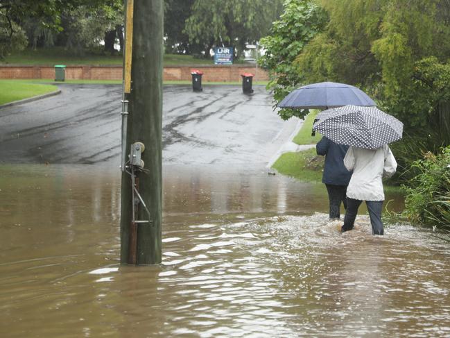
Ellie Dudley12.47pm:Evacuation warning along Hawkesbury River
An evacuation warning has been issued to people in the lower reaches of the Hawkesbury River from Wisemans Ferry to Brooklyn.
The northwestern Sydney residents have been instructed to gather their essential items, warm clothes and insurance documents in preparation to potentially evacuate.
The Hawkesbury River at Wisemans Ferry was expected to reach the major flood level (4.20m) around 10.00am Tuesday morning.
Further river level rises are possible with forecast rain on Tuesday.
Emergency services have urged evacuated people to stay with family or friends where possible, otherwise evacuation centres have been established at:
• Castle Hill RSL, 77 Castle St, Castle Hill
• Richmond Club, East Market St, Richmond
• North Richmond Community Centre, William St, North Richmond
Mackenzie Scott12.40pm:‘Life-threatening’ rain hits Queensland
Residents near ten southeast Queensland waterways are on alert for minor to major flooding as “life-threatening” heavy rain continues to beat the already sodden region and reignites fears of flash flooding and landslips
A major flood warning was in place for the Logan River at Beaudesert on Tuesday morning. Forecasters at the Bureau of Meteorology expect the river, which runs through southwest Brisbane and the Gold Coast Hinterland to the NSW border, to rise by more than a metre over the course of the morning to surpass 8.3m.
Non-stop rain overnight delivered 50mm to 150mm in areas of the southeast. The hardest hit locations over the 24 hours to since 9am Monday included Mt Tambourine (220mm) and Upper Springbrook (191mm) on the Gold Coast, while North Stradbroke Island reported 202mm.
Current warnings areas include Warwick, the Gold Coast, Toowoomba, Brisbane, Ipswich, Coolangatta, Stanthorpe, Cleveland, Gatton and Jimboomba.
Conditions are set to worsen in the region over the course of Tuesday, with the heavy rain band set to take the pressure off the eastern Darling Downs region and concentrate on the east coast. Afternoon and evening thunderstorms are expected to heighten rainfall and create heavy winds across southern and southeast Queensland
A warning issued by the BOM at 10:30am on Tuesday said flash flooding risks continue to be a concern.
“Heavy rainfall which may lead to flash flooding continues about the southern parts of the Darling Downs and Southeast Coast districts,” the BOM said.
“The situation continues to pose a serious risk to areas affected by heavy rainfall, including the risk of landslips in steep terrain in these areas the situation may become life-threatening. Six-hourly rainfall totals of 100-150 mm are likely, and locally heavier falls are possible with thunderstorms.”
Queensland State Emergency Crews have received 840 calls for help this week since Sunday morning. Up to 120 homes are being inspected for damage, and four houses on the Gold Coast have been evacuated due to the risk of landslides. At least 20 schools were closed.
Previous severe weather warnings have been cancelled for the Central West, Wide Bay and Burnett and Maranoa and Warrego districts.
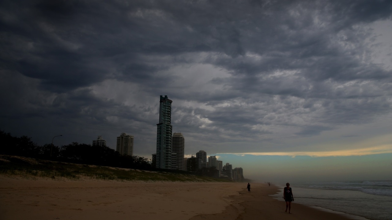
Remy Varga12.29pm:Further warnings issued in Victoria
Minor flooding could occur in parts of Gippsland and along the Otway coast this afternoon with up to 200mm of rain expected to fall, the Bureau of Meteorology has warned.
The BOM issued a flood watch warning on Tuesday as a deepening low pressure system over western NSW moves towards eastern Victoria.
Catchments likely to be affected include:
• Bemm, Cann and Genoa Rivers
• Snowy River
• Thomson River
• Latrobe River
• Traralgon Creek
• South Gippsland Rivers
• Otway Coast
âš ï¸ Marine #Wind Warning issued for storm force winds with wind gusts possible in excess of 90km/h or 48 knots at #EastGippsland Coast, for today and Wednesday.
— Bureau of Meteorology, Victoria (@BOM_Vic) March 23, 2021
Check https://t.co/sbyDLK9TR8 for details and warnings for other coastal waters. @vicemergency@MaritimeTSVpic.twitter.com/Z57Q2WRjcW
BOM is forecasting up to 120mm of rain in far east Gippsland, up to 150mm rain in the Otway Ranges and between 150 to 200mm of rain in the Strzelecki Ranges.
A marine wind warning has also been issued for the East Gippsland coast, with gusts exceeding 90km/h possible.
Ellie Dudley12.02pm:Queensland SES respond to hundreds of calls for help
As rain continues to pelt the south of the state, Queensland emergency services are responding to hundreds of calls for help.
SES crews have received 840 requests for assistance this week, while up to 120 homes are inspected for damage.
âš ï¸ Severe weather warning updateâš ï¸ Rainband bringing heavy rainfall to southern and southeast Queensland today and tonight. Flood Watch and warnings are current #IfItsFloodedForgetIt. Latest warning details and updates: https://t.co/jc45yRSZifpic.twitter.com/NfslS8sCGx
— Bureau of Meteorology, Queensland (@BOM_Qld) March 22, 2021
Four houses on the Gold Coast have been evacuated due to the risk of a landslide.
Areas between Brisbane and the Gold Coast have had up to 30mm of rain in the past three hours.
Some parts of the state are expecting 50-100mm over the next six hours.
Remy Varga11.47am:Flood warning issued for Snowy River in Victoria
A minor flood warning has been issued for the Snowy River in Victoria, with up to 130mm rain expected to cause river overflows at Bombala and McKillops Bridge.
VicEmergency said the Snowy River at McKillops Bridge in East Gippsland would reach minor flood level by Tuesday afternoon, with catchment currently at 2.25 metres.
Areas in Gippsland that were affected by fire last year are more susceptible to the impact of heavy rainfall forecast for today, & face a greater risk to the dangers of floods and landslides.
— VICSES News (@vicsesnews) March 22, 2021
Stay up-to-date with the latest weather warnings via @BOM_Vic: https://t.co/U2WKNwpsM4pic.twitter.com/ZzoOi9seWo
“The Snowy River at McKillops Bridge is currently at 2.25 metres and rising,” the warning said.
“(It) is likely to reach the minor flood level (2.50m) Tuesday afternoon.”
The river is expected to remain at minor flood level until Tuesday afternoon.
On Twitter, Victoria State Emergency Service said regions burnt in the 2019/20 bushfire season face a greater risk of floods and landslides.
Ellie Dudley11.41am:Flood warning for NSW south coast
The State Emergency Services (SES) have issued a flood warning for areas of the NSW south coast following heavy rainfall in the area today.
The areas affected are:
• Illawarra Coast;
• Shoalhaven River (minor flooding);
• Clyde River;
• Tuross River;
• Bega River (minor to moderate flooding);
• Towamba River;
• Queanbeyan and Molonglo Rivers (minor flooding)
The SES are urging residents to prepare their homes by raising movable items as high as possible onto benches or tables, keeping a close eye on pets and checking on friends and family.
Cliona O’Dowd11.39am:Flooding prompts reinsurance, share price analysis
As insurers grapple with rising claims from the NSW and Queensland floods, analysts are looking ahead, gauging the impact on reinsurance and share prices.
Morgan Stanley expects the record-breaking rains around Sydney and other parts of Australia will lead to a CAT event and add to reinsurance pricing pressure.
“Feedback from all reinsurers is (that) aggregate covers are proving costly, and we think this event adds to pressure for July renewals,” the broker told clients in a note.
February 2020 saw a similar event, but with stronger winds, the analysts noted.
For that flood event, the industry saw around $900m gross claims. However, IAG was capped at $135m by reinsurance and Suncorp at $155m.
Reinsurance sees insurers transfer portions of their risk portfolios to other companies, to protect against having to pay out large sums from insurance claims.
Ellie Dudley11.28am:Payne confirms defence involvement in NSW today
Acting Defence Minister Marise Payne has confirmed defence force helicopters will be deployed today to assist in search and rescue activities amid NSW’s flood emergency.
Australian Defence Force (ADF) personnel and equipment will also be used later this week to assist with the “clearance and recovery operation”.

“Defence is working with the NSW State Emergency Operations Centre to determine how it can further support and assist state emergency services with tasks such as assessing damage to properties, clearing roads and helping restore electricity and water,” Ms Payne said in a joint statement with Emergency Management Minister David Littleproud.
“Defence is well-equipped to provide further assistance if required, which was demonstrated last year when the ADF provided support during the Black Summer bushfires, throughout COVID-19 and the recent bushfires in Western Australia.”
Mr Littleproud added the hard work of removing flood affected property contents will be both demanding and dangerous.
Mr Littleproud said the ADF would provide “comfort” to those in flood affected communities.
“The amount of flood and storm debris to be removed will be enormous and could be overwhelming for those trying to put their lives back together,” he said.
“They will be given comfort when the men and women in uniform turn up, stand shoulder to shoulder with them and get the job done.”
MORE: Follow the latest from Canberra in our live blog, PoliticsNow
Eli Greenblat11.18am:NSW floods hit coal miner
Whitehaven Coal has lowered its production and sales guidance for fiscal 2021 as devastating floods in New South Wales threaten to block key roads and disrupt its workforce.
To add to its problems, equipment issues have forced the Port of Newcastle to suspend coal shiploading, which will slow its coal sales.
Further, wild weather has forced a backlog of ships outside the Port of Newcastle, with 40 vessels lined up.
The $1.8 billion coal group said it was now projecting managed coal sales from its operations to be 18.5 million tonnes to 19m tonnes, down from the initial guidance of 19m to 20m tonnes for the period.
It said managed run of mine (ROM) coal production was now forecast to be 21.4m tonnes to 22m tonnes, down from an initial forecast of 21m to 22.5m tonnes.
Ellie Dudley11.09am:Bureau of Meteorology to provide update this afternoon
The Bureau of Meteorology will provide a flood update in a press conference at 1pm.
BOM NSW Manager Jane Golding and Water Manager Victoria Dodds will address the crisis ravaging NSW and parts of Queensland and Victoria.
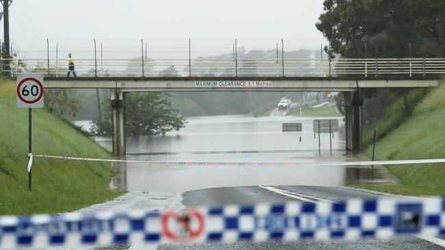
Ellie Dudley10.47am:Evacuation order for Hawkesbury residents
A flood evacuation warning has been issued by the SES to all residents in caravan parks along the Hawkesbury River from Windsor to Wisemans Ferry.
Residents must prepare to evacuate should river levels continue to rise following further rainfall expected on Tuesday.
The Hawkesbury River at Windsor peaked at 12.75 metres around 6.00pm on Monday, with major flooding.
The Hawkesbury River at Sackville is currently nearing a peak of 9.5 metres with moderate flooding.
The Hawkesbury River at Wisemans Ferry is expected to have reached the major flood level (4.2m) at around 10.00am Tuesday morning.
The SES has instructed residents to monitor the situation and be prepared to evacuate when instructed to do so.
An evacuation order will be issued by the NSW SES if evacuation is required.
Ellie Dudley10.27am:Rain to clear in Sydney late this afternoon: BOM
The Bureau of Meteorology says the rain in Sydney will clear from as early as mid-to-late afternoon today.
While parts of the city have experienced up to 70mm of rainfall in the 24 hours to 9am, the BOM expects the downpour to ease this afternoon before a sunny day tomorrow.
#Sydney rain expected to begin clearing from mid to late afternoon. #flood2021#ColoRiver#HawkesburyRiver#NepeanRiver latest info at https://t.co/3jYZ7110Jjpic.twitter.com/yQTgEZndqo
— Bureau of Meteorology, New South Wales (@BOM_NSW) March 22, 2021
NSW again saw large amounts of rainfall in the 24 hours to 9am, including 150mm at Moree.
Areas on the far north coast of the state including Chillingham and Couchy Creek experienced up to 120mm.
Greg Brown9.50am:If it’s flooded, forget it: Morrison
Scott Morrison has urged Australians under threat from floods to “remain calm” as he warns the weather patterns in NSW and parts of Queensland remains “dynamic and extremely complex”.
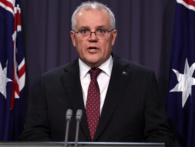
“This is a complex weather event and (it’s) becoming more complex,” the Prime Minister said.
“Severe weather, high winds, damaging surf and heavy rain is forecast for the east coast today and the system is causing heavy rain.
“As difficult as this issue is, people are remaining calm. We need to see them continuing to follow the instructions that are out there. If it is flooded, forget it. Do not go out for a surf.
“I say that to people including in my own electorate when I had reports of people going out there yesterday. Do not do it. You are putting not only yourself at risk but those who would come to have to help you also.”
He said people should feel confident that state agencies were “world class” and able to deal with the crisis.
Ellie Dudley9.45am:Updated list of evacuation centres in NSW
The State Emergency Services (SES) have updated the list of evacuation centres across New South Wales.
While evacuated residents are being urged to stay with family and friends as to not overburden the emergency services, the following centres remain open:
• Bulahdelah – Bulahdelah Golf Club – Recovery Road, Bulahdelah;
• Port Macquarie – Port Panthers – 1 Bay Street, Port Macquarie;
• Port Macquarie – Port Macquarie Golf Club – 698 Ocean Drive, Port Macquarie;
• Laurieton – The Laurieton United Services Club – 2 Seymour St, Laurieton;
• Kempsey – Kempsey Showground – 19 Sea St, West Kempsey;
• South West Rocks – South West Rocks Country Club – 2 Sportsmans Way, South West Rocks;
• Taree – Club Taree – 121 Wingham Rd, Taree;
• Wingham – Wingham Golf Club – 30/32 Country Club Drive, Wingham;
• Cundletown – Manning Valley Anglican College – 94 Princes St, Cundletown;
• Old Bar – Club Old Bar – 1 Belford St, Old Bar;
• Tuncurry – Tuncurry Bowling Club – 21 Parkes St, Tuncurry;
• Harrington – Harrington Function Centre – 1-7 Caledonia St Harrington;
• Manning Point – Manning Point Bowling Club – 22 Manning St Manning Point;
• Richmond – Richmond Club – 6 East Market Street, Richmond;
• North Richmond – North Richmond Community Centre – 33 William Street, North Richmond;
• Castle Hill – Castle Hill RSL – 77 Castle Street, Castle Hill;
• The Entrance – Diggers at The Entrance – 315 The Entrance Road, Long Jetty
Remy Varga9.33am:Flash flooding warning issued in Victoria
A flash flood warning has been issued for the east and west Gippsland regions in Victoria as the weather system causing chaos in NSW moves south.
A SEVERE Weather Warning has been issued for today, Tuesday 23 March, for DAMAGING WINDS & HEAVY RAIN across parts of East & West Gippsland. The tail of the weather system currently impacting NSW will see rainfall with possible FLASH FLOODING. More info: https://t.co/CvgmAt2eHdpic.twitter.com/SdoIxOaFeR
— VICSES News (@vicsesnews) March 22, 2021
The Victoria State Emergency Service said on Tuesday the “tail” of the weather system in NSW would see damaging wind and heavy rains in parts of Gippsland.
Ellie Dudley9.02am:Decision yet to be made on Warragamba: Barilaro
Deputy Premier John Barilaro has said the NSW government is yet to make a decision on how to prevent the Warragamba Dam from flooding in the future.
The Warragamba Dam, Sydney’s primary water supply, reached full capacity on Saturday and has been spilling hundreds of gigalitres of water since then, threatening communities along the Nepean River.
The disaster has brought up an ongoing debate surrounding the government’s commitment to raise the dam wall to prevent overflow onto the flood plains.
Mr Barilaro said that might not be the solution due to “opposition” against the decision.
“There’s a lot of debate around the heritage area,” he told Sky News. “There’s a lot of opposition.
“We will have to make a decision for Warragamba. What is the solution that stops future spilling?”
He added that the government would take a more considered look at the dam once the floods end.
“We are in the middle of a disaster now,” he said.
Mr Barilaro defended the state government against criticism from federal Emergency Management Minister David Littleproud that they allowed development of houses on flood plains.
“David Littleproud wants to talk politics at a time when people are feeling unsafe. Now is not the time for a debate,” he said.
He also took a swipe at Mr Littleproud’s handling of the Murray-Darling Basin in 2019, saying: “We haven’t got water for irrigators, we haven’t got water for the environment.”
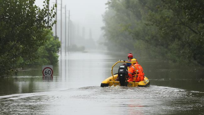
Ellie Dudley8.55am:‘High danger zone’: Colo River residents evacuated
Residents on the Colo River are currently being evacuated from their homes by boat or helicopter, as the area is declared a “high danger zone”.
Following earlier warnings, an evacuation order has been issued by the State Emergency Services (SES) for all properties along and adjacent to the Colo River.
Roads out of the valley have already been cut by flood water.
“From 8am this morning you should be ready to be evacuated from your home via helicopter or boat,” the order reads.
“You can only take essential items with you such as essential items, warm clothes, medicines, insurance documents and valuables.”
Ellie Dudley8.38am:ADF to begin assistance on NSW south coast
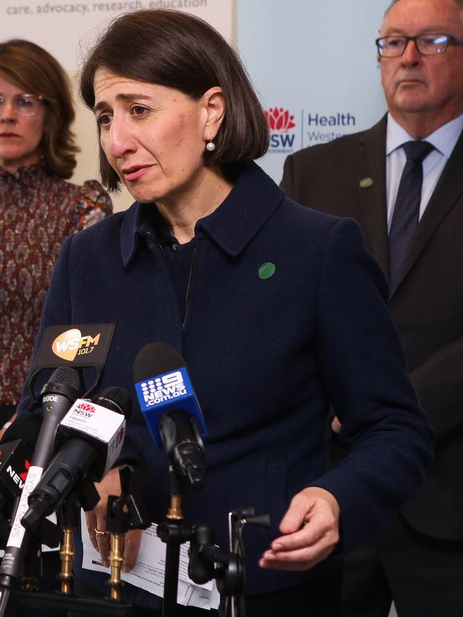
NSW Premier Gladys Berejiklian has confirmed two defence force aircraft will be assisting on the south coast today, as the state government puts in a request to their federal counterparts for ADF assistance with the clean up on the mid-north coast.
“We have asked for assistance to start some of the clean up where we can in the Northern Rivers and the mid-north coast,” she said.
“I am very certain that will be forthcoming.”
Ms Berejiklian said the “vast majority of people” are still in crisis management, but the NSW government are looking ahead to the clean up and recovery phases of the disaster.
Meanwhile, two ADF aircraft will be “at the disposal” of the NSW government to assist with extreme weather on the south coast today.
She also gave a message of hope to anyone who is stranded by flood waters currently that help is on its way.
“The weather conditions are drastic. For those reasons, we are limited in some regions in our way to help people,” Ms Berejiklian said.
“No matter where you live, no matter how isolated you feel, help will get to you.
“In the meantime please stay somewhere safe.”
Ellie Dudley8.19am:Premier’s warning as new front moves through NSW
Gladys Berejiklian has warned of an additional weather front moving through inland New South Wales in areas which are yet to be hit by the deluge.
“Concerningly (there is) an additional weather front coming through which will impact inland NSW,” Ms Berejiklian said.
Carlene York, Commissioner of the SES said areas in inland NSW, including the central lakes and Macquarie region should expect extreme weather as the front moves down from Queensland.
“It’s raining heavily in the western part of NSW and we expect some significant outcomes from that rain,” she said.
The existing weather front on the eastern coast and Sydney area, Commissioner York said is still “expected to be significant today”.
Ms Berejiklian confirmed an additional 15,000 people may need to be evacuated today, on top of the 18,000 who have been relocated so far.
“The government has set up a number of evacuation centres, but the number of people in those centres is relatively low which suggests that most people have been able to take our advice and stay with family and friends,” she said.
A total of 16 evacuation orders and 16 evacuation warnings have been issued to parts of NSW with more to come today.
While the sun is expected to come out tomorrow, Ms Berejiklian has said “it does not mean the danger has passed”.
“Quite the contrary,” she said. “Many river systems are still taking major flows and many rivers continue to rise so they could be flooding in communities we have not anticipated.”
Adrian McMurray7.50am:NSW Premier to provide flood update shortly
NSW Premier Gladys Berejiklian will speak shortly. Ms Berejiklian will be joined by Police and Emergency Services Minister David Elliott and NSW State Emergency Service Commissioner Carlene York. You can watch the press conference live at the top of this blog from 8am AEDT.
Ellie Dudley7.20am:Residents to evacuate as Colo River rises
Residents on the Colo River, northwest of Sydney, are being urged by emergency services to prepare for evacuation as the flood levels in the area continue to rise.
The State Emergency Services (SES) issued an evacuation warning for the area overnight, but Deputy Commissions Daniel Austin said it is likely people in the area will be forced to relocate this morning.
“We will likely see an evacuation order go out this morning,” he told Sky News.
âš ï¸ #Flood Warning issued for #Hawkesbury#Nepean and #Colo rivers. major flooding at #NorthRichmond and downstream. Significant major flood peak forecast for #UpperColo. See https://t.co/4lgk9cYtI4 for details and updates; follow advice from @NSWSES. #NSWFloodspic.twitter.com/G8k13s0feQ
— Bureau of Meteorology, New South Wales (@BOM_NSW) March 22, 2021
Anyone in an area affected by flood waters must remain “hyper vigilant”, he added.
Overnight, the SES conducted 24 flood rescues, which Mr Austin said was a “pleasing number” for this stage in the disaster.
“People are doing the right thing, but just getting caught in rapidly moving waters,” he said.
A total of 16 evacuation orders and 16 evacuation warnings have been issued to parts of NSW with more to come today, Mr Austin said.
Ellie Dudley7am:Southern Queensland braced for extreme weather
Southern Queensland was soaked with pelting rain overnight as the state braces for more extreme weather today.
Parts of Brisbane and the Gold Coast received between 100mm and 200mm on Monday, which only worsened the already swollen waterways that had received similar rainfall levels throughout the region on Sunday.
The Gold Coast hinterland was the worst hit, with the suburb of Tambourine drenched with more than 250mm of rain.

More than 660 calls for assistance have been made across the state since Sunday morning.
Flood warnings are in place for the following areas:
■ Maroochy and Mooloolah Rivers;
■ Logan and Albert Rivers;
■ Nerang and Coomera Rivers;
■ Balonne River;
■ Weir River;
■ Moonie River;
■ Lower Warrego River (Qld);
■ Lower Paroo River (Qld); and
■ Barcoo and upper Thomson Rivers.
The Gold Coast and Brisbane areas will see around 150-200mm of rain today.
Ellie Dudley6.30am:NSW declares 38 disaster zones as deluge continues
Another massive deluge is expected to hit NSW today, as heavy rainfall is dumped across the state and spreads further south.
More than 18,000 people were forced to evacuate from their homes yesterday — 15,000 on the north coast of NSW and around 3000 in the Richmond Valley region, Premier Gladys Berejiklian said.
A total of 38 disaster zones have been identified in regional NSW and western Sydney. People in those communities are eligible for government assistance of up to $1000 for adults and $400 for children.
Emergency services received more than 8,000 calls for help since the rain began on Thursday, 1485 of which were in the 24 hours to Monday evening.
Around 125 rescues were conducted, 70 of which in the Sydney area.
Flood warnings remain in place for the following areas:
■ Snowy River;
■ Weir River;
■ Macquarie River to Bathurst;
■ Myall River;
■ Richmond River;
■ Camden Haven River;
■ Nambucca River;
■ Paterson and Williams Rivers;
■ Wallis Lake;
■ Paroo River;
■ Castlereagh River;
■ Gwyndir River;
■ Orara River;
■ Tuggerah Lake;
■ Deua River;
■ Hawkesbury, Nepean and Colo Rivers;
■ Wollombi Brook;
■ Lower Hunter River;
■ Manning and Gloucester Rivers;
■ Hastings River;
■ Macleay River;
■ Bellinger River;
■ Clarence River; and
■ Wilsons River.
A flood watch has also been issued for parts of the Northern Rivers, mid-north coast, Sydney, south coast, south west, central west and north west.
The rain is spreading to the south of the state, with the south coast expecting 200-300mm of rain on Tuesday.
Kieran Gair6.10am:Windsor neighbours help mates, refuse to evacuate
In assembly-line style, residents on Church Street at Windsor in Sydney’s flood-hit northwest worked hand-in-hand against the raging Hawkesbury river.
“We are all family here,” said Nanette Cooper, as she guided Darren Cini’s sandbag-laden ute through the rapidly rising floodwaters.
As the swollen river surged beyond its banks, engulfing large swathes of Windsor on Monday, the focus on Church Street turned to saving number 176.
The property’s owner, Jason Adams, was red-eyed and emotional as neighbours delayed evacuating the flood-ravaged area in order to help out an old mate.
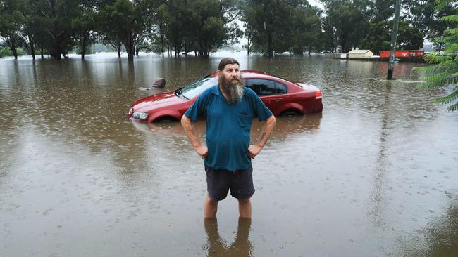
“We are in the firing line,” Mr Adams said, as he fought back the tears. “This is our home of 30 years, and we are about to lose it all. We couldn’t sleep a wink last night.”
In Windsor, flooding is a fact of life. The Hawkesbury river rose to 13m in 1990, while in the floods of 1961 it climbed to a then record 15m. This time around, the river could peak at 16m on Tuesday.
And while the estimated 700 residents who live on Church Street have weathered the devastation wrought by floods before, they concede this one is different.
Read the full story here.
Rhiannon Down5.10am:‘Critical day’ as mega-rain events merge
Thunderstorms and another deluge are predicted to lash NSW and southeast Queensland on Tuesday as a second rain band bears down on the east coast, sparking fears of further flooding, with conditions not expected to clear until Wednesday.
The Bureau of Meteorology warned Tuesday would be another “critical day” as already flooded rivers overflow and volatile storm pockets threaten to bring torrential rain. Heavy rain of 100-200mm, which caused widespread flooding across Sydney’s west, the Hunter and mid-north coast on the weekend, has moved into Queensland.
Tuesday was predicted to be another wet day across the map with 30-40mm forecast for Brisbane, 45-80mm in Sydney and 40-70mm in Port Macquarie.
The rain band was also predicted to move south into eastern Victoria and Tasmania, with Mallacoota predicted to receive between 40-70mm on Tuesday and 10-35mm on Wednesday.
BOM duty forecaster Jonathan How said the second wet weather event was predicted to arrive on the east coast from the Northern Territory today, bringing “another critical day” as it merges with the existing rain band.
“We’re really concerned about the rainfall from early Tuesday morning into southern Queensland and Brisbane right down the NSW coast and the ACT and central tablelands into Gippsland,” Mr How said.
“There are concerns for heavy rain and the heaviest storms, which could bring thunderstorms.”
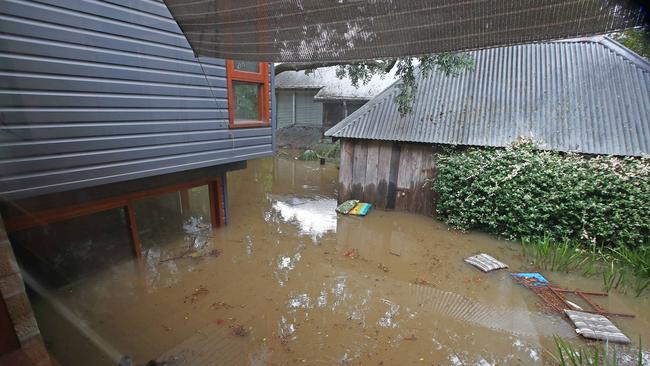
Stephen Rice5am:Floods crisis deepens as bill hits $2 billion
Torrential rain on Tuesday is expected to worsen the flood crisis gripping the NSW mid-north coast and western Sydney, adding to a damages bill that already exceeds $2bn and forcing thousands more evacuations.
As Scott Morrison placed the Defence Force on alert to assist flood-bound communities and sent two search and rescue helicopters, Emergency Management Minister David Littleproud criticised the NSW government for allowing residential development on flood plains, particularly the Hawkesbury-Nepean Valley.
Mr Littleproud said he expected state governments, which had authority over local governments, to tighten planning regimes to take into account natural disaster risks.
“The Australian taxpayer can’t keep coming back and owning this. We can’t be the insurer of last resort,’’ Mr Littleproud said.
Read the full story here.
Nicholas Jensen4.45am:More shelters needed as levels tipped to rise
Evacuation centres across the mid-north coast remain inundated with hundreds of residents and stranded visitors, as local officials scramble to resolve acute shortages in emergency accommodation before conditions deteriorate.
On Monday morning State Emergency Services confirmed 15,000 residents had been evacuated along the mid-north coast, and more evacuations were likely.
Robert Dwyer, who manages the Laurieton evacuation centre, in one of the hardest-hit regions, said “while we are bracing for another stint of wild rain, there are urgent plans happening about how we are going to expand some of the emergency accommodation over the next couple of weeks”.
Read the full story here.
More Coverage

Add your comment to this story

Deeming peace offer to Libs, Pesutto collapses
Moira Deeming offered John Pesutto a dramatic peace deal — but it came with strings attached.

Premier refusing to quit as potential replacements line up
Jeremy Rockliff persuaded colleagues not to have a requested meeting of the Parliamentary Liberal Party on Wednesday, amid mounting calls for him to quit.
To join the conversation, please log in. Don't have an account? Register
Join the conversation, you are commenting as Logout