More rain, floods forecast for NSW in ‘evolving’ disaster
Rain will continue to batter much of the eastern seaboard as another wet front moves from inland.

Rain will continue to batter much of the eastern seaboard as another weather front arrives from the inland offering no respite toareas of NSW that were hammered by heavy flooding at the weekend.
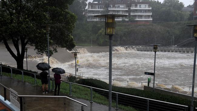
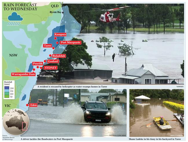
The Bureau of Meteorology warned conditions would remain “treacherous” for much of NSW until Wednesday after hundreds ofmillimetres fell on hard-hit regions, sparking evacuations and major flood warnings in Sydney’s west and on the mid-north coast as rising water levels destroyed houses and livestock.
BOM climatologist Agata Imielska said the outlook for the Greater Sydney area, the Hunter and mid-north coast remained grim, with more rain expected to compound rising water levels.
Sydney has a near 100 per cent chance of rain on Monday, while Tuesday has a 90 per cent chance, with between 30mm to 70mm predicted each day, meaning an additional 140mm could be on its way.
Port Macquarie, which received the brunt of the storm on the weekend, can also expect no relief with 50mm to 80mm forecast on Monday and 40mm to 70mm on Tuesday.
“(On Monday) we are expecting it to really intensify for that particular region, so be very mindful for the communities out there,” Ms Imielska said.
“They have already experienced very dangerous conditions, and they are going to be treacherous yet again. So keep a close eye on warnings, and again, expect those river rises and flood risk to continue.”
Ms Imielska said the bureau was bracing for a second deluge that would move from the Northern Territory and drench northern inland NSW on Monday before merging with the existing front and then moving towards the south coast on Tuesday.
“We are seeing a rain band which will move across the state from the west, bringing significant falls to the northern inland, including areas such as the northwest slopes and plains,” she said.
“For those regions, we could see totals up to four times the March monthly average in just two days.
“We are also likely to see a low-pressure system develop on the south coast, bringing heavy rainfall to this region. It is likely to combine moisture from both this rain band as well as moisture off the coast, which will act as a conveyor belt bringing in those heavy falls on a Tuesday, specifically for the south coast area.”
BOM flooding expert Justin Robinson urged residents near Penrith in Sydney’s west to monitor flood warnings closely after the area was predicted to have broken a 60-year flood record.
“We are expecting the situation to evolve,” he said.
“At Penrith, the river levels are still rising. Over the next couple of days flood water level will move down stream and start impacting North Richmond, Windsor, and Penrith.”
NSW SES deputy commissioner Dean Storey said emergency services were preparing to issue more evacuation orders and flood warning over the coming days. “The community needs to follow advice and heed those directions immediately,” he said.
“If where you live or what you are currently located is subject to a flood of warning, prepare accordingly; understand what that means for your local area.”
Ms Imielska said there would be little relief for the state until Wednesday when showers should ease significantly.
“There will still be a shower or two, a bit of activity, but significantly lighter rainfall. Wednesday will be the first day when we could see a bit of reprieve across the state,” she said.
Senior meteorologist Dr Adam Morgan said the meeting of the two weather fronts would give a “kick” to the rain.
“It’ll move into southwest parts of Queensland on Monday and Tuesday it’ll stretch across the east in towards the Darling Downs and Gold Coast and you could see similar sorts of rainfall totals 40mm-80mm on Tuesday though southern Queensland,” he said.
“When it clears off the south coast on Wednesday the far east of Victoria may click a bit of rain, but not the kinds of totals that we were seeing in NSW. “We might see 10mm to 25mm on Wednesday through far East Gippsland on Wednesday, also the north east of Tasmania could see around 40mm to 60mm by Thursday.”
Add your comment to this story

‘Nine concealed evidence:’ BRS’s bombshell mistress claim in High Court appeal
Ben Roberts-Smith is seeking a new trial that allows his former mistress to give evidence about her explosive secretly recorded conversation with Nine reporter Nick McKenzie.

How accused Bali shooters tried to escape
Three Australians have been arrested over the slaying of Melbourne man Zivan Radmanovic — with details of how they allegedly tried to evade capture released.
To join the conversation, please log in. Don't have an account? Register
Join the conversation, you are commenting as Logout