Up to 1000 properties could be evacuated as heavy rain hits east coast
Intense rainfall on the east coast has prompted authorities to issue warnings for Murwillumbah and the Tweed areas.
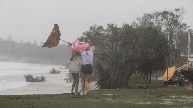
Bit by bit they’re watching the hope of a bumper Christmas wash away in the foaming swells breaking on Main Beach, Byron Bay, and all the way north to Queensland’s Gold Coast.
The beaches should be humming on the eve of high season, packed with holiday-makers enjoying the sun and the sand, the restaurants and pumping bars.
Nowhere more than Byron Bay — playground of the rich and famous on the NSW north coast, more popular than ever as a getaway for Sydneysiders this year after travel interstate or overseas was nixed by COVID-19.
Instead it was battened down under a cold, grey curtain of rain for the third day running as a brooding complex trough and low-pressure system offshore maintained its grip on 650km of coastline between Coffs Harbour, NSW, and World Heritage-listed Fraser Island north of Brisbane.

All points between were being pounded by destructive seas.
Byron Bay’s Main Beach was hit by king tides and 100km/h winds that pushed the churning surf on to sandbag barriers, the last line of defence. On the Gold Coast, 10m breakers crashed ashore, too dangerous for even the hardiest board rider.
Who knew what damage was being done to drawcard beaches?
“At this stage we haven’t got a full grasp of what the longer-term damage has been for our coast,” Byron Shire mayor Simon Richardson said, admitting the community was holding its breath.
“We know there’s still going to be another king tide and big weather over the next 24 hours … so at this stage we’re just waiting to see what the next salvo is.
“Then hopefully we can have the opportunity to see what sort of damage and what sort of price tag we’ve got.”
SES answers hundreds of calls for help
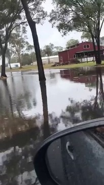
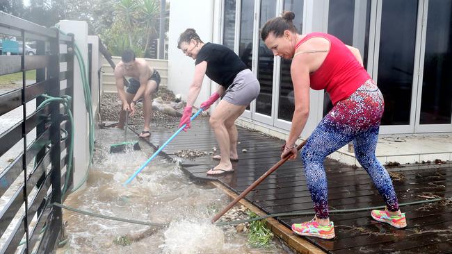
The NSW state emergency service received nearly 1200 calls since midnight on Thursday, and about 90 last night.
There have been nine flood rescues – for people stuck in their cars in flood water – with three reported overnight.
NSW SES Deputy Commissioner Daniel Austin said “intense” rainfall across the north east coast prompted authorities to issue evacuation warnings for Murwillumbah and the Tweed areas.
“We believe across the isolated communities and those that are subject to those warnings, potentially up to 1000 properties could well be involved,” Mr Austin told the Nine network’s The Today show.
“It has been really heartening to see the number of calls that we’ve received for self-help – so people looking to arrange sandbags and be proactive in the approach and we really thank the community for having stepped into that space,” he said.
SES crews in Queensland have received about 1400 calls for help over the weekend, Queensland and to Fire and Emergency Services deputy commissioner Mark Roche said.
“Even though now we’re expecting that some of those winds and some of that heavy rainfall may be easing the reality is we’re asking people to be vigilant – to ensure that they stay out of the floodwaters and that they drive with caution,” Mr Roche said.
High tides are expected to reach 1.8m near Tweed Heads, and a king tide was expected to hit Ballina, near Byron Bay about 9:30am.
NSW Premier Gladys Berejiklian said the NSW SES had been preparing for months to cope with the surge in storm activity.
“All the weather experts have been telling us we’re likely to see very extreme weather conditions with the La Nina effect impacting the East Coast of Australia, in particular NSW,” Ms Berejiklian told The Today show.
“We have seen that in the Tweed and Murwillumbah communities and surrounding townships ... we need to expect the unexpected, that is what 2020 has taught us,” she said.
Warnings issued for NSW
Queensland SES commissioner, Nicole Hogan said evacuation warnings had been issued to residents in Tumbulgen and Tweed Valley Way, on the NSW side of the Queensland border.
“The worst hit areas that we’ve experienced are in Tweed Heads,” Ms Hogan told the ABC.
“There was significant rainfall within the Tweed area last night and we also had significant weather in Coffs Harbour and Lismore,” she said.
“We have over 300 resources from across the state supporting our northern New South Wales teams, as well as resources from Fire & Rescue, New South Wales RFS and NSW Police in support of this particular operation.”
Strong wind warnings have been issued for the Byron Coast, Coffs Coast, Macquarie Coast and Hunter Coast after they copped combined rainfall totals of more than 100 millilitres of rain since midnight.
Torrential rain is also expected to continue due to a surface trough along the northeast NSW, extending into southeast Queensland.
It's been a wild weekend for #SEQLD & nthn #NSW with torrential rain, damaging winds & flash flooding with heaviest falls at Upper Springbrook with 738 mm (72 hours to 9am this morning AEST).
— Bureau of Meteorology, Australia (@BOM_au) December 14, 2020
Latest forecasts - https://t.co/ZHKvBUIPxD
🎥 Reece Russell, Ballina, NSW pic.twitter.com/3pGOzOSy1L
Conditions are not forecast to let up until later Tuesday or early Wednesday as the trough weakens.
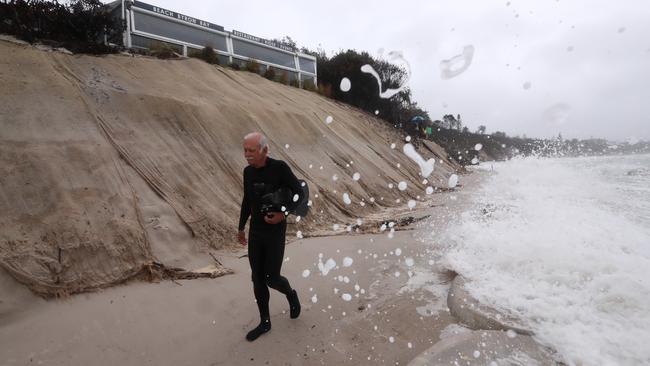
After Byron Bay’s iconic Main Beach vanished on Monday, the Bureau of Meteorology warned damaging surf and swells in excess of 5m could wash away more beaches at Port Macquarie on Tuesday.
Moderate to Major flooding is expected along the Tweed River today and minor flooding expected on the Bellinger river in northern NSW after it peaked 6.05 metres, above the 3.07 metre minor flood level.
In Queensland, Springbrook copped 230mm of rain and about 900 since the start of the wild weather on the weekend.
Motorists put on notice
The good news is that this opening blast of Australia’s La Nina summer appears to have topped out, with the Bureau of Meteorology predicting the cyclonic conditions are set to ease.
Not before time. Gold Coast mayor Tom Tate warned that authorities might have to block low-lying roads with “hard closures” — an unwanted reminder of the COVID barriers at the border that have only just come down — to save reckless drivers from themselves.
“I keep saying when it’s flooded forget it,” Mr Tate said, pointing to several near misses with motorists who had driven into floodwaters.
“If it’s an emergency, take the long route … I’ve been getting reports people are still driving through, so I want to get the message out there we’ll do hard closures.”
In Cleveland on Brisbane’s bayside, the storm surge poured across the esplanade and into garages, littering roads with debris. An estimated 6000 homes and premises were without power across the city, with another 1500 blacked out in the Gold Coast hinterland.
North of the capital, the king tide appeared to break through a sandbank near popular Golden Beach on the tip of Bribie Island. The sea poured through a gaping 2m hole in the bar, prompting the Queensland Parks and Wildlife Service to issue an alert for people to steer clear of the breach.
Local volunteer coast guard commander Roger Pearce said another swollen 2.02m tide due at 8.30am Tuesday could cause more problems. “There is undoubtedly more water coming,” he told The Courier-Mail.
The fear in Byron Bay and the Gold Coast is that the beaches made unsightly or even unusable by erosion could ruin the party just as tourism ramped up for the sorely needed Christmas peak.
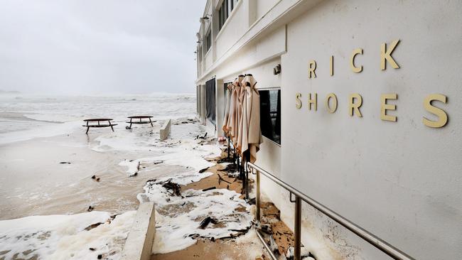
At the Beach Byron Bay venue, managing director Ben Kirkwood was grateful that sandbagging on Main Beach had protected the popular restaurant and function centre.
Back in June, an east coast low stripped away 6m of sand dune frontage and every king tide since had taken more, he said. The 300m sand wall had been completed only last month, barely in time to save the day.
“Thank goodness they did because this building would have been gone,” Mr Kirkwood said.
The mayor said the storm had capped a “horrendous couple of years” for the community. “We had floods in 2018, we’ve had coastal erosion issues, we’ve had drought and bushfires and COVID,” Mr Richardson said.
“So our patience as a community has been tested, and the mettle of our community has been tested. But we’re still standing and we know from a tourism point of view that we’ll bounce back very quickly.”
BOM forecaster Rosa Hoff said the powerful weather system would weaken from Tuesday, moderating the torrential downpours and gale-force winds lashing the seaboard.
Additional reporting: Angelica Snowden
Add your comment to this story

Update after car ploughs into shopping centre
Chaos broke out as an allegedly stolen SUV smashed through a major shopping centre in Melbourne’s north.

Australian universities drop in global rankings | LIST
Despite 70 per cent of our universities slipping in the latest global rankings, Australia is still considered the fifth-best higher education system in the world.
To join the conversation, please log in. Don't have an account? Register
Join the conversation, you are commenting as Logout