Anger on wrong side of Echuca levee as hope drains with peaking floodwater
Anger among residents on the wrong side of Echuca’s dirt levee is reaching a crescendo, as some lose all hope of remaining dry ahead of a high water mark expected to be reached overnight.
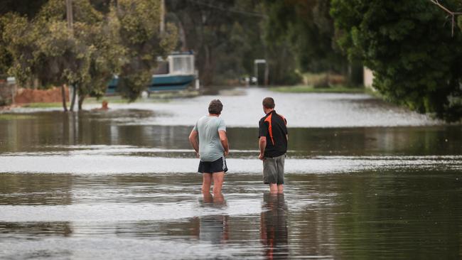
More than 10 days after the deluge that has inundated thousands of homes across Victoria, floodwaters are finally peaking in the Murray River town of Echuca.
Anger among residents on the wrong side of the northern Victorian town’s 2.5km-long, 2m-high dirt levee is also reaching a crescendo, as some lose all hope of remaining dry ahead of a high water mark expected to be reached overnight on Sunday into Monday.
Early last week, residents exposed to the Campaspe River experienced the town’s first flood peak, and since then those on the northern and eastern side of town have grown increasingly nervous as a wall of water slowly made its way down the Goulburn and into the Murray.
While the levee was still keeping the majority of the town dry late on Sunday afternoon, it had forced water into and around houses on Pakenham St, Moama St and Goulburn Rd.
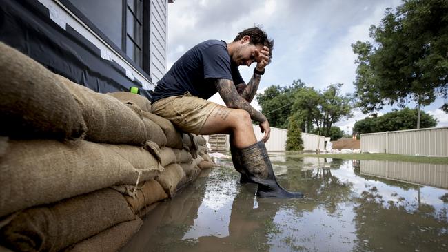
Emotions were running high as a group of six locals including Jade Walsh drove through metre- deep floodwater on Goulburn Rd to urgently lay sandbags along houses on the wrong side of the levee.
“I’m past that (being angry). I’m broken,” Mr Walsh said from a tinnie packed with sand bags.
“We’ll just keep going. No one else will save us.”
Louise, Erin and John McCann sat on their front porch with their dog Haydie and friend Ben Abel and looked at their front yard that was at knee-level height with water. “We are proper angry,” Louise said.
“We started building this front levee two weeks ago,” Erin said.
“If the shire had done the same thing with that levee (and put it out the back), we wouldn’t be in water right now.”
They intend to stay in their home until water laps at the front door.
It would take more than another 30cm of water to destroy their home of 40 years.
Bobby Lang – also on the wrong side of the levee on Goulburn Rd – stood in his front yard of eight years after it had been swamped with water on Sunday afternoon.
He monitored the level of the water, which had not yet breached the 1m-high sandbag wall around his white weatherboard home, and said he and his partner would sleep in their swag until the floodwater receded.
“It’s frustrating,” he said. “There was no transparency and no one really told us or gave us a bit of time before they put it up.
“A lot of people panicked. And when we started sandbagging no one knew how to do it properly.
“It was too late for houses down there.”
Northwest Victoria will be struck by more storms in the next two days, with 15mm-30mm expected on Monday before rain moves south, clearing by midweek.
In Echuca, the Murray is expected to peak at 94.9m above sea level on Sunday and into Monday. River levels at the Echuca wharf have already exceeded the October 1993 flood level of 94.77.
The water level has risen by about 5m since early September.
An evacuation message for the town is still active, with residents urged to leave their homes amid the threat of isolation.
“At Echuca, the Murray River is one of the most challenging hydrological areas to model,” Victorian SES chief officer Tim Wiebusch said on Sunday.
Downstream from Echuca, flooding will occur from Torrumbarry to Barham on Wednesday and Thursday, potentially to higher levels than in 1993 and 2016 events, Mr Wiebusch warned.
Meanwhile, Kerang residents have cause for optimism after the Loddon River peaked at 77.97m, although it is expected to remain steady for several days. For now, Kerang remains “generally not accessible”.
Flood levels in Rochester have receded to minor levels but could rise again, albeit not to the extent seen last weekend, if the town is hit by high-end rainfall.
The prognosis is similar for Shepparton and Mooroopna, where flood levels have also ebbed to minor levels in some parts.
Renewed rainfall over the next two days could force another river surge to around 11m, but that would be a “significantly different” outcome to the 12.05m peak recently seen in the region, Mr Wiebusch said.
Flooding is forecast for Swan Hill but not until next week, according to the Bureau of Meteorology.
Swan Hill’s major flood level mark is 4.7m, with the peak a chance to surpass that figure once the Murray’s surge moves further downstream.
More Coverage

Add your comment to this story

Australia won’t join France in recognising Palestine as state: PM
Anthony Albanese has backed away from France’s movement to recognise a Palestinian state by September, but has slammed the ‘completely indefensible’ civilian death toll in Gaza.

WA Libs vote to scrap welcome-to-country, net-zero targets
The moves pile further pressure on Opposition Leader Sussan Ley as she faces a growing Coalition uprising among the party’s dominant conservative faction.
To join the conversation, please log in. Don't have an account? Register
Join the conversation, you are commenting as Logout